Indiana’s lakes are vital natural resources that provide drinking water, recreational opportunities, critical wildlife habitat, and economic benefits to communities across the state. Whether you live along a lake, enjoy boating and fishing, or simply appreciate the beauty of these waters, how all of us interact with and care for Indiana’s lakes has a lasting impact. This page provides information about lakes and guidance for property owners, residents, and visitors on responsible lakefront living. By working together, we can preserve the natural beauty and ecological health of Indiana’s lakes for years to come.
The Indiana Department of Natural Resources (DNR) supports lakes throughout Indiana in a variety of ways. The Division of Fish, Wildlife & Nature Preserves stocks fish in public waters and manages fishing and boating licenses and property and public access on DNR property on public freshwater lakes. Conservation officers enforce laws and regulations related to boating, fishing, safety, and other recreational opportunities. The Division of Water has multiple roles related to public freshwater lakes, including regulating development, compliance with permits, tracking water availability and use, floodplain mapping, and providing technical assistance. A different agency, the Indiana Department of Environmental Management (IDEM), is responsible for the management of water quality of Indiana Lakes.
Understanding Indiana’s Lakes
Understanding the different types of lakes and key lake concepts is important for effective management, conservation, and appreciation of these ecosystems. Knowing how lakes function and how the actions of humans affect them is key to protecting and improving a lake’s health for future generations. Whether you live on a lake, recreate on one, or simply value the role lakes play in Indiana’s environment, this introduction provides the foundation for making thoughtful, science based decisions that benefit both people and nature.
Indiana is home to a wide variety of lakes. Whether you enjoy boating, fishing, wildlife watching, or simply relaxing by the water, it helps to understand the types of lakes that you may find throughout the state. Indiana lakes fall into three main categories: natural glacial lakes, man-made reservoirs, and oxbow lakes.
Natural Glacial Lakes

Northern Indiana is dotted with natural lakes formed thousands of years ago during the last Ice Age. Around 14,000 years ago, the Wisconsin glacier’s movement across the landscape carved out the lakes that we still enjoy today. Kettle lakes form when ice from a glacier gets buried in sediment and slowly melts over time leaving behind a depression. That pit will then fill with water, forming a lake. Examples of natural lakes in Indiana include Lake Wawasee, the largest natural lake in Indiana at 3,000 acres, and Tippecanoe Lake, the deepest natural lake in Indiana at 123 feet.
Reservoirs
 Reservoirs are artificial lakes created by damming rivers or streams to store water. In Indiana, many reservoirs were developed for flood control, water supply, and recreation. These lakes tend to be larger and deeper than natural lakes. They are often elongated, following the shape of the flooded river valley. Some reservoirs in Indiana have control structures that will change the water level multiple times a year depending on the needs of the reservoir. Examples of reservoirs include Monroe and Patoka lakes.
Oxbow Lakes
Oxbow lakes are typically crescent-shaped lakes that form when a bend in the river is cut off from the main channel. These lakes are more commonly found in the southern part of Indiana, where the Ohio and Wabash rivers have shifted their paths over time. Oxbow lakes are typically shallow and rich in nutrients. Hovey Lake Fish & Wildlife Area in Posey County includes a 1,400 acre oxbow lake.
Public Freshwater Lakes
Public freshwater lakes are managed by the State for the benefit of all Hoosiers. The public has the right to use these lakes for boating, fishing, swimming, and other recreational activities, though rules may vary by location. DNR manages and regulates certain activities on public freshwater lakes to ensure environmental protection, safety, and fair use. Examples of ways that DNR may be involved with public lakes include fish stocking, boating permits, vegetation management, and construction.
A public freshwater lake must be at least 5 acres in size, including bays and coves. It also must have existed before March 12, 1947, when the original lake preservation laws were enacted. A list of public freshwater lakes was developed for the public to easily identify which lakes in Indiana are registered as public freshwater lakes with DNR.
Private Lakes
Private lakes are owned and managed by individuals, utilities, associations, conservancy districts, or private organizations. Typically, these lakes are not open to the general public or access to them is limited. While private lakes are not subject to the same public access rules, they must still comply with state laws related to water management, dam safety, and environmental protection. If a lake is not on the public freshwater lake list, then it is considered private.
 Recreation
Lakes provide year-round opportunities for recreation, including swimming, fishing, boating, paddling and wildlife observation. These activities are more than just leisure – they stimulate local economies through tourism and support healthy lifestyles and also strengthen community connections. The clarity, safety, and ecological health of a lake directly influence its recreational value.
Wildlife
Lakes serve as complex and dynamic habitats that support aquatic plants, invertebrates, fish, amphibians, birds, and mammals. Shallow areas with vegetation offer spawning grounds and shelter, and they become an oxygen rich refuge for certain fish species in summer. Seasonal temperature shifts, nutrient availability, and dissolved oxygen levels influence which species thrive. By protecting these habitats, we preserve biodiversity and maintain key ecological functions, such as nutrient cycling and food web stability.
Drinking Water
Freshwater lakes are critical water sources for many municipalities. Water drawn from lakes typically undergoes treatment to remove sediment, pathogens, and chemical contaminants; however, the quality of untreated lake water depends on factors such as land use in the watershed, nutrient and sediment inputs, and the presence of harmful algal blooms. Protecting shoreline vegetation, managing stormwater runoff, and reducing pollutant sources help safeguard the purity of drinking water supplies. IDEM has developed a Source Water Protection Program to help protect sources of drinking water.
Industry
Industries can rely on lakes for processing, cooling, product manufacturing, and occasionally transportation. Withdrawals and discharges can influence water levels, temperature, and chemical composition, potentially impacting aquatic life. Best management practices such as using closed-loop water systems or advanced treatment for discharge water allow industries to meet operational needs while maintaining water quality. Balancing economic use with ecological stewardship ensures that lakes remain a viable resource for both business and community needs. To help combat the amount of pollution entering Indiana’s lakes, IDEM permits the direct discharge of pollutants to waters through the National Pollutant Discharge Elimination System Permit Program.
Lake levels fluctuate every day from many influences like precipitation, evaporation, groundwater exchange, and water withdrawals. These changes can occur over different time scales, from short-term shifts caused by weather to long-term trends influenced by extended drought periods and human activity. Many lakes follow an annual cycle, with levels peaking in the spring or early summer due to snowmelt and increased runoff. Levels then typically fall through late summer and fall.
How Groundwater Affects Lake Levels
Lakes and groundwater are often connected, exchanging water through the surrounding sediments, depending on elevation, geology, and seasonal conditions. Water levels like to be in equilibrium with water flowing from the higher level to the lower one through the surrounding soil. When the groundwater table is higher, it adds water to the lake. When the lake is higher, it sends water back into the groundwater. In groundwater-fed lakes, seepage can help stabilize water levels during dry periods. These “gaining lakes” can also recharge groundwater aquifers when the lake water level is higher than the surrounding water table. Periods of drought can lower groundwater tables leading to lower lake levels. If your lake is abnormally low, you can check the Indiana Drought Information website to see if your area is in a drought. Human activities such as high-volume well pumping or land development can interrupt groundwater flow patterns, leading to lower lake levels or changes in seasonal fluctuations. Understanding this connection helps communities protect lake health and manage water resources wisely.
Isolated Lakes

Isolated lakes are self-contained systems that do not have an inlet or an outlet. They are fed solely by precipitation and groundwater. They can have unique ecosystems and be sensitive to fluctuations in rainfall and groundwater. These types of lakes are usually easier to manage. Pleasant Lake, which is south of Angola in Steuben County, is an example of one of these lakes.
Connected Lakes

Connected lakes are part of a river network and have inlets or outlets that connect them to the waterways. They are fed by precipitation, groundwater, and surface water flow. These lakes tend to have higher biodiversity but can also bring in higher nutrients and invasive species. The health of the lake is factored more by outside influences, making it more difficult to manage. The lakes of Chain O’Lakes State Park in Noble County are an example of connected lakes.
Legal Lake Levels
A legal lake level in Indiana refers to the average normal water level set by the county court system for a public freshwater lake through IC 14-26-4. The average normal water level is an elevation set between the high water level that occurs as a result of excessive precipitation and low water level that occurs during prolonged dry periods. Lakes should ideally be maintained at their established levels; however, natural fluctuations can occur due to weather. DNR is not responsible for maintaining legal lake levels, but there is a list of existing legal lake levels that is available to the public.
Lakes are divided into zones that differ in sunlight penetration, temperature, and biological activity. The size of the zones can vary between lakes and is usually dependent on water clarity and composition like suspended sediment and phytoplankton. The physical and chemical conditions in each zone shape the types of life it supports, and together they form an interconnected aquatic ecosystem.

Littoral Zone – Near shore, sunlit waters where aquatic and semi-aquatic plants grow, providing shelter and feeding grounds for fish, amphibians, and invertebrates. It is typically shallow and has high amounts of nutrients from runoff and inbound water sources.
Limnetic Zone – Open-water surface area where photosynthetic algae (algae that needs sunlight to grow) and plankton thrive, forming the base of the food web. It is the part of the lake that is the warmest and receives the most sunlight. The zone ends when sunlight can no longer penetrate the water. The higher amounts of sunlight and oxygen allow for fish to thrive in this zone.
Euphotic Zone – The top layer of water with sunlight. Photosynthesis can be supported in this zone. It is a highly productive area since algae and aquatic plants can thrive in it. The depth of the euphotic zone depends on the lake’s water clarity. The clearer the lake, the deeper the zone.
Profundal Zone – Deep, dark water below the reach of sunlight. Oxygen here can become depleted in summer, influencing which organisms can survive. Water temperature can be significantly colder due to the lack of sunlight.
Benthic Zone- The area along the floor of a lake including the sediment that builds up at the bottom of a lake. This is where bacteria decompose and break down organic matter. Older lakes can have larger benthic zones.
Many of Indiana’s lakes, especially deeper ones formed by glaciers, go through predictable seasonal changes known as stratification and turnover. Most lakes deeper than 20 feet will undergo turnover twice a year in the spring and fall. These natural patterns affect oxygen levels, water temperature, and nutrient movement throughout the year.
 Source: National Geographic Society
In spring, melting ice and warming temperatures create isothermal conditions, causing the water to be nearly the same temperature from top to bottom. Strong spring winds help mix the water in the lake. Oxygen from the surface mixes with the bottom, and nutrients trapped at the bottom mix through the water column.
As summer sets in, the sun warms the surface faster than heat can reach the bottom. The warmer, less dense water stays at the top of the lake while cold, denser water stays at the bottom of the lake. This creates three distinct layers:
- Epilimnion - The warm, upper layer that receives sunlight and supports most aquatic life and algae growth.
- Thermocline – The middle layer where the warm epilimnion and the cold hypolimnion mix contain the thermocline. The thermocline has the greatest temperature and density difference and separates the other two layers from each other.
- Hypolimnion - The cold, dense bottom layer that holds less oxygen because it is cut off from surface mixing. This layer has the potential to become anoxic (no dissolved oxygen), which can result in few organisms being able to live in this layer. Decomposition of organic matter can accelerate oxygen loss, sometimes causing fish kills during hot, calm weather.
In fall, cooler air temperatures and wind break down the thermal barrier, and the water mixes from top to bottom. The surface water cools and sinks, and fall winds help mix the water. This turnover replenishes oxygen throughout the lake and stirs up nutrients from the bottom. The process can temporarily make the water appear cloudy, but it is essential for ecosystem balance.
In winter, ice forms on top, insulating the water below. The coldest water stays just under the ice, while the slightly warmer water settles at the bottom. Some shallow lakes may still mix under the ice, but deeper lakes remain layered until spring.
Lakes are often classified based on their “trophic state,” a measurement of their biological productivity that includes algal growth. Free-floating algae, or phytoplankton, are responsible for the majority of primary production in a lake. The trophic state of a lake can determine what recreational activities will be desirable on it. Many people prefer to swim and recreate on lakes with clear water, resulting from low primary production levels. Nutrient supply, climate, and the lake shape can impact a lake’s trophic state. Phosphorus and nitrogen are two nutrients that are necessary for algae and other phytoplankton. Phosphorus is typically the limiting nutrient in lake ecosystems, and as phosphorus levels increase, the amount of algae increases. Excess nutrients have been a significant source of pollution to lakes worldwide over the past century. When lakes move toward a more eutrophic state, there are many undesirable consequences, such as harmful algal blooms, taste and odor issues, increased cost of water treatment, fish kills, and altered aesthetics.
Carlson’s Trophic State Index is the most commonly used equation to calculate the trophic state of a lake. It uses water clarity (Secchi depth), nutrients (phosphorus) and overall algal biomass (chlorophyll-a) measurements when calculating the trophic state. The Indiana Trophic State Index is a modified version of the BonHomme Index that was specifically designed for lakes in Indiana. It uses a wider variety of physical, chemical, and biological parameters to calculate the trophic state of a lake.
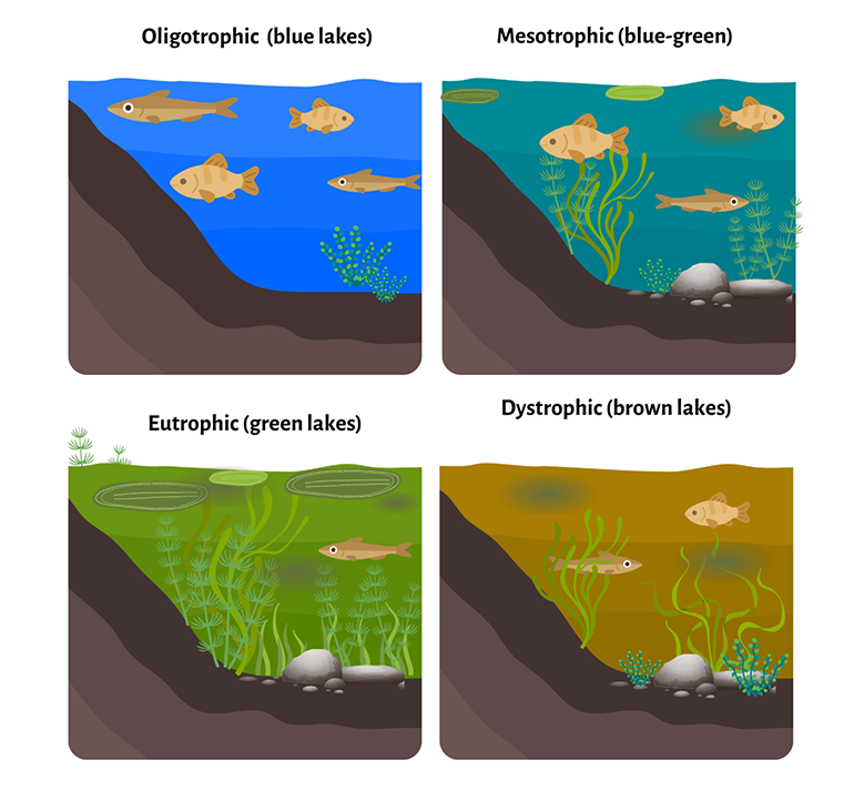
Oligotrophic
Oligotrophic lakes have low amounts of nutrients and algae and high water clarity. Oligotrophic can have low amounts of aquatic vegetation due to the low amounts of nutrients. The whole water column is typically well oxygenated, which can allow them to support cold-water fish such as trout or cisco. These lakes are usually preferred for recreation usage.
Mesotrophic
Mesotrophic lakes have moderate nutrient levels, which results in higher amounts of productivity, algae, and aquatic vegetation compared to oligotrophic lakes. The water is typically not as clear as oligotrophic lakes. They have a decent amount of dissolved oxygen but can have decreased oxygen concentrations in deeper waters. Mesotrophic lakes can support abundant aquatic life and are good for fishing warm-water species.
Eutrophic
Eutrophic lakes are nutrient rich, resulting in high productivity but excessive algal growth. Poor water clarity and low levels of dissolved oxygen at the bottom of the lake make it hard for most fish species to thrive or survive there. Eutrophic lakes can result in impacted aquatic ecosystems, water quality deterioration, biodiversity loss, and human health problems caused by toxins produced by harmful algal blooms. These lakes typically only have warm-water fish, predominately bass.
Hypereutrophic
Hypereutrophic lakes have even higher nutrient concentrations compared to eutrophic lakes and are characterized by frequent and severe nuisance algal blooms, and their transparency is typically less than 1.5 feet. They are considered to be highly productive lakes, which results in being dominated by algae scum on the surface of the lake and can have extremely low dissolved oxygen even toward the surface of the lake, which can result in summer fish kills.
Dystrophic
Dystrophic lakes are typically acidic and have high organic matter but low nutrients, algal, and zooplankton. The water can have a brown or dark tint and have low transparency. In Indiana, these lakes are usually caused when the surrounding vegetation has high amounts of peat. The high acidity can negatively impact wildlife and recreational use.
All trophic states can occur naturally, but human activities can increase the amount of nutrients that enter a lake, which can shift its trophic state to eutrophic or hypereutrophic lakes. Lawn fertilizers, septic systems, wastewater treatment plants, runoff from agricultural fields, and erosion from development can add nutrients to a lake. When a lake shifts to a different trophic state, it is important to understand if it is naturally occurring or is occurring due to human impacts that may result in negative consequences.
Indiana's Lake Preservation Act (IC 14-26-2) safeguards the natural resources and scenic beauty of public freshwater lakes as a public right. Shoreline additions like seawalls and underwater beaches can compromise this natural beauty, defined as the natural condition of the environment without constructed additions or alterations.
To balance preservation and development, shorelines are categorized based on existing lawful alterations and the presence of emergent wetland vegetation. These classifications, evaluated during permit reviews, dictate the approved materials for seawalls and the permissible size of underwater beaches.
The four shoreline classifications, from most to least protected, are:
- Significant Wetland
- Natural Shoreline
- Area of Special Concern
- Developed Area
To ensure accurate assessments, the Division of Water's Technical Services Section conducts on-site lake inspections beginning in spring when emergent vegetation becomes visible. These inspections are crucial in reviewing permit applications for seawalls and underwater beaches.
Significant Wetland

A significant wetland can be (1) a transitional area between terrestrial and deep-water habitats containing at least 2,500 square feet of contiguous, emergent vegetation or rooted vegetation with floating leaves landward or lakeward of the shoreline/water line OR (2) an adjacent wetland areas designated by a federal or state agency under the National Wetlands Inventory USACE Wetlands Delineation Manual (1987) or National Food Security Act Manual (1994), OR (3) has an endangered, threatened, or rare species.
Natural Shoreline

A natural shoreline is a continuous section of unaltered shoreline or water line where the distance between lawful permanent structures is at least 250 feet.
Area of Special Concern

An area of special concern is an altered shoreline that has vegetation of at least 625 square feet in area and less than 2,500 square feet in area.
Developed Area

This shoreline includes the upland side or sides of a man-made channel or an area that does not contain any of the other shoreline classifications. The upland side of a man-made channel is sections of a shoreline along a man-made channel where there is less than 625 square feet of contiguous emergent vegetation or rooted vegetation with floating leaves.
Common Problems
Understanding common problems in lakes is essential for effective lake management. It allows identification of the root causes of declining lake health and helps identify what lake management techniques would be best at addressing the problem. By understanding common problems, individuals can gain the insight needed to prioritize actions, allocate resources efficiently, and implement interventions that support long term lake health rather than temporary fixes. The information below gives a brief summary of some of the common problems that can affect lakes in Indiana. It is not a complete list.
Sedimentation occurs when soil from eroding farmland, construction sites, or bare shorelines flows into lakes. This process fills the lake basin over time, making it shallower and altering its habitat. As sediment builds, sunlight can reach the bottom more easily, promoting excess plant growth and warming the water. Fine sediment can smother fish eggs and clog gills of aquatic organisms. When a lake gets shallower, it can increase flood risk and decrease recreational and property value.
What you can do: Keep shorelines vegetated and stabilized, minimize bare soil on your property (plant native grasses and trees to stabilize soil), reduce agricultural runoff, and redirect stormwater to slow water movement and increase infiltration before it enters the lake.
Nutrients like phosphorus and nitrogen are essential for aquatic plants, but too much causes problems. Runoff from fertilizers, lawn care, livestock manure, and failing septic systems introduces excess nutrients in the lakes.
Too many nutrients, especially phosphorus, fuel algal blooms, which can include harmful cyanobacteria (blue-green algae). These blooms block sunlight, which can result in a loss of aquatic plants, reduce oxygen when the algae die off, and can release toxins that irritate skin or harm pets and wildlife. When algae die and decompose, the process uses up oxygen in the water, which can result in fish kills. Nutrient enrichment (overly excessive amounts of nutrients in lakes cause eutrophication) also speeds up the natural aging of lakes, leading to murky water and poor habitat conditions.
What you can do: Use phosphorus free lawn fertilizer, avoid using fertilizer or fertilizing before heavy rain, maintain vegetated buffers around shorelines, pick up pet waste, and maintain your septic system regularly. Lakes can be treated for phosphorus removal, but it is an expensive treatment, so it is recommended to prevent phosphorus from entering the lake.
Invasive plants and animals can quickly change lake ecosystems by disrupting the natural balance that natives rely on. Invasive plants often grow faster, reproduce more quickly, or have no natural predators, which allows them to out-compete native species. This can shift the food web, which results in fish and other wildlife losing key food sources needed to maintain healthy populations.
Once established, invasive species are difficult and expensive to remove that often requires long-term management. Nuisance species that result in thick plant growth or sharp mussel shells can limit swimming, boating, fishing, and overall enjoyment of a lake. Invasive plants like Eurasian watermilfoil, curly leaf pondweed, and starry stonewort form dense mats that block sunlight and crowd out native plants. Invasive fish and invertebrates like zebra mussels attach to boating equipment and spread rapidly due to improper cleaning in between transfer to different bodies of water, they filter water excessively, and they negatively alter the food web.
What you can do: Clean, drain, and dry your watercraft and gear before moving between lakes and never release aquarium fish, plants, or bait into lakes or streams. Avoid transporting bait between bodies of water. Choose native plants on your property and monitor your lake to detect invasive species early.
E. coli and other pathogens enter lakes through runoff contaminated by animal waste, broken sewer lines, or failing septic systems. Swimming in contaminated water can lead to stomach illness, skin infections, and ear or eye irritation. High concentrations can lead to swimming advisories or closures, as they signal the possible presence of disease-causing organisms. While not all strains of E. coli cause illness, their presence is used as an indicator that other harmful pathogens could also be in the water. Warm, shallow waters and heavy rain events may increase the likelihood of contamination.
What you can do: Inspect and maintain septic systems regularly, keep livestock and pets away from waterways and ditches, and dispose of pet waste properly.
Resources for Responsible Lakefront Living
Responsible lakefront living in Indiana is vital for preserving the state’s aquatic ecosystems. As a landowner, your management choices directly impact the health of the lake that you live on. By maintaining your properties with best management practices and practicing responsible boating, residents can help protect the biodiversity of native species and ensure that Indiana’s lakes remain vibrant recreational hubs for future generations.
Lakeshores play a vital role in supporting wildlife, protecting water quality, and enhancing the beauty of Indiana’s lakes. The Lakescaping for Wildlife and Water Quality – Indiana Addendum provides guidance on creating and maintaining natural shorelines using native vegetation. By reducing erosion, filtering pollutants, and providing habitat for birds, fish, and pollinators, lakescaping helps sustain healthy aquatic ecosystems. Property owners can implement these practices to improve their local lake to have a thriving native plant species and protect the shoreline.
Healthy ponds and lakes look at the physical, chemical, and biological features of the body of water. The DNR’s Private Pond and Lake Management page provides resources for managing private bodies of water. Examples of resources on this page provide information about aquatic vegetation, how to test your water, maintenance, wildlife structures, and more.
Lakes in Indiana may have water control structures associated with them like dams, levees, outlets, and spillways. These structures help control the direction or rate of flow, maintain a desired water surface elevation, or measure water. Indiana has 1,388 jurisdictional dams in the state. Under Indiana Code section 14-27-7.5-7, the owner of a structure shall maintain and keep the structure in operating condition. The DNR Dam Safety Program regulates the construction, operation, and maintenance of Indiana’s dams to protect life and property from damages due to the failure of dams. The program also assists with emergency preparedness activities. You can learn more about water control structures and management of them at this website.
Proper maintenance of septic systems is crucial for preventing pollution in lakes, ponds, and groundwater. Failing septic systems can release excess nutrients and E. coli that can lead to harmful algal blooms and water contamination, resulting in humans or animals getting sick or dying. It is estimated that there are more than 200,000 inadequate or failing septic systems throughout Indiana that introduce approximately 15.3 billion gallons of raw sewage into the environment annually. Homeowners should generally have their system inspected every three years by a licensed professional, and have their tank pumped when necessary, typically every three to five years. You can learn more tips on how to be septic smart at this website or at IDEM’s septage management webpage.
Eutrophication, sedimentation, acidification, and toxic contamination are common problems caused by pollution in runoff that can affect lakes. There are steps landowners can take to prevent or lower their impact on local lakes. You can minimize the amount of turf, pesticides, herbicides, and fertilizer that is applied to your lawn and make sure it is phosphorus free. If you do apply any chemicals or treatments to your lawn, make sure to thoroughly read the directions to apply it correctly and at the right time to minimize effects on the surrounding environment. You can make sure to clean up or compost leaves and grass clippings so they don’t wind up in the lake and decompose, using up oxygen that fish and plants need to survive. Leaves from autumn can become a stored nutrient in the lake, which can create a problem when the weather warms. Algae and aquatic invasive species will use the stored nutrients in the spring to quickly flourish. Last, make sure any waste from pets is picked up and properly disposed of. Pet waste that ends up in bodies of water or in the storm drain can contain harmful bacteria, which can make people and animals sick. The nutrients from pet waste may increase weed and algae growth, which can further damage the health of the lake and the surrounding area.
Aquatic invasive species (AIS) are plants, animals, and other organisms that are not native to Indiana waters and have the potential to cause harm. These species are concerning because they outcompete native species, threaten human health, change and degrade the ecosystem, and/or require intense maintenance and monitoring. The damage to sport fisheries and commercial resources from AIS can be serious. Some common AIS species in Indiana include Eurasian watermilfoil, curly leaf pondweed, starry stonewort, silver carp, and zebra mussels.
AIS can be expensive or impossible to control. For instance, Indiana spends an estimated $1 million per year in public waters to chemically control Eurasian watermilfoil. DNR has developed an AIS plan for the state and has dedicated webpages where you can find more information about specific AIS. Make sure to see if you need an Aquatic Vegetation Control Permit Application before removing any vegetation or use a certified consultant. The best way to control AIS is by preventing them from entering other lakes. It is important to properly clean your boat and equipment and take the pledge to be an Indiana Clean Boater.
Sometimes wildlife can become a nuisance for people recreating on lakes. Typically, such nuisance wildlife is causing damage or threatening to cause damage to a property or poses as a health or safety threat to a person or domestic animal. Some wildlife require a Nuisance Wild Animal Control Permit before it can be removed. DNR’s website describes which wildlife may be removed without a permit and which ones require a permit for removal. DNR also has specific guidance for how to manage mute swans and Canada geese and their nests. DNR does not provide removal or capture services for nuisance wildlife; however, DNR has a wildlife control operator list and a waterfowl control operator list for the public to use.
Lakes are home to a vast variety of species and many more species that depend on lakes for at least one part of their life cycle. Nearly 160 species of greatest conservation need depend on Indiana lakes. Lakes serve as breeding or feeding grounds for many species and house important ecosystems for aquatics species to thrive. It is important to keep these habitats healthy or restore them with natural and best management practices. Michigan has resources for shoreline best management practices that landowners can implement on their land. DNR has programs that landowners can use for habitat restoration, including the Lake and River Enhancement Program, Reservoir Habitat Enhancement Program, and other DNR Fish, Wildlife & Nature Preserves habitat assistance programs. DNR also has the Lakescaping for Wildlife and Water Quality – Indiana Addendum that goes over some best management practices.
Boater safety is essential in Indiana, where lakes draw thousands of residents and visitors each year for fishing, water skiing, swimming, and relaxing on the water. While boating is a favorite way to enjoy Hoosier lakes, it also comes with responsibilities. DNR emphasizes education and awareness to protect both seasoned boaters and newcomers. The Indiana Boat Safety Handbook can help you complete your boaters safety education. DNR has lake depth and vegetation maps for various lakes throughout the state that can be used for boating. The DNR Where to Fish map includes locations of boat ramps throughout the state.
DNR Fish, Wildlife & Nature Preserves has an extensive webpage on fishing in the state, including information on where to fish, best practices, licenses, and information on fish species. There is also the Where to Fish interactive map that has information on public access sites, fish consumption advisories, and low-head dam locations. Fishing licenses are required for anglers 18 or older. Be aware when ice fishing about the depth of the ice and local conditions, and be sure to drill test with holes that have a 4 inch thickness of clear ice before going out on the lake. Check fish consumption advisories before eating your catch of the day. Last, make sure to read up on the Indiana and Lake Michigan fishing reports. DNR also has lake depth and vegetation maps for various lakes throughout the state.
Regulations in Indiana Administrative Code 312 IAC 5-6-1 allow for the establishment of special boating zones on public freshwater lakes to govern the operation of watercraft. Ecozones can protect or address unusual conditions or hazards, fish, wildlife, botanical resource management, or the protection of users. Several ecozones have been established to protect natural shorelines and shallow water areas in multiple lakes, including Wawasee, Syracuse, Tippecanoe, James (Kosciusko), Olin, Simonton, and Manitou.
Lake associations, conservancy districts, or other groups interested in exploring the establishment of an ecozone should call the DNR’s Division of Fish, Wildlife & Nature Preserves at 260-244-6805. Its staff will work with other divisions, including the Division of Law Enforcement, to consult with the local organization and help determine if there is adequate public support for an ecozone.
Permits and Regulations
Permits and regulations are essential in Indiana to safeguard public freshwater lakes as shared resources and to protect their ecological health. They help ensure that the public will be able to use and enjoy lakes while maintaining long-term preservation.
The DNR Division of Water is charged with overseeing several water-related state statutes, including construction activities that occur on and by lakes. Despite the Division of Water operating under multiple statutes, only one permit application form, State Form 42946 Permit Application for Construction, is needed when applying for a permit. The Division of Water has developed a permit program webpage that houses information about the permitting process. The Indiana Waterways website houses DNR and IDEM waterway permitting information, including the Waterways Inquiry Request form, which can be used to help landowners determine which permits are needed for a potential project.
While most projects under the purview of the Division of Water require a formal permit from our office, some projects may not require a permit. Specific exemptions and general licenses exist for certain projects, and if a project meets the requirements of the general license or exemption, then a formal permit is not required. Many general licenses and exemptions can proceed without coordination with the Division of Water or written documentation; however, some specify that written notice or other coordination is needed. Details on these exemptions can be found below under the relevant statute.
Below is a list of the statutes that the Division of Water works with. An individual should also consult with IDEM and USACE on any permits needed that involve construction or placing fill in a lake.
Lake Preservation Act
The Lake Preservation Act (IC 14-26-2) requires the prior approval of the DNR Division of Water for any construction or project that is proposed below the legal or normal water level and located over, along, or lakeward of the shoreline or within 10 feet landward of the shoreline for construction of a wall with a lowest point that is below the shoreline elevation of a public freshwater lake. Example project types might include but are not limited to new and refaced seawalls, underwater beaches, dredging, boat ramps, and boat well construction and fill. A list of the state’s public freshwater lakes can be found here.
Certain construction activities on lakes that meet the specifications can qualify for a general license. These activities include aerators, boat lifts, dry hydrants, glacial stone reface, and temporary piers.
Certain lakes are exempt from the Lake Preservation Act for some or all construction activities. Wolf Lake and Lake George are fully exempt, while Lake Shafer and Lake Freeman have partial exemptions. There are some exemptions for other types of lakes listed on our website.
Lowering of the Ten Acre Lake Act
The Lowering of the 10-Acre Lake Act (IC 14-26-5) requires prior approval of the DNR Division of Water for the construction, reconstruction, repair, or recleaning of any ditch or drain that is within a half-mile of a freshwater lake of 10 acres or more and where the project will have a bottom depth lower than the normal water level of such lake; however, a permit is not required for construction on a ditch or drain that empties into a lake if the ditch or drain continues to empty into the lake at the same location after the construction activities are completed and if best management practices for soil and erosion control are implemented. Example project types might include but are not limited to ditch construction and/or reconstruction, dredging, and tile drain installation and/or repair.
Navigable Waterway Act
The Navigable Waterways Act (IC 14-29-1) requires the prior written approval of the DNR Division of Water for placing, filling, or erecting a permanent structure in a navigable waterway or Lake Michigan. A second permit is not required if the project is being permitted under the Flood Control Act, Sand and Gravel Permits Act, or Construction of Channels Act. A listing of the state’s navigable waterways is located on our website.
Sand and Gravel Permits Act
The Sand and Gravel Permits Act (IC 14-29-3) requires the prior approval of the DNR Division of Water for removal of sand, gravel, stone, or other mineral or substance from or under the bed of a navigable waterway. A listing of the state’s navigable waterways is on our website.
Construction of Channels Act
The Construction of Channels Act (IC 14-29-4) requires the prior approval of the DNR Division of Water for construction of a channel connecting to any river, stream, or lake for the purpose of providing access by boat.
Flood Control Act
The Flood Control Act (IC 14-28-1) requires the prior approval of the DNR Division of Water for any proposal to construct an obstruction, fill, excavate, or construct a building in the floodway area of a stream or other flowing body of water that has a drainage area greater than 1 square mile. Example project types might include but are not limited to bank stabilization; construction of a new stream crossing or maintenance of an existing stream crossing; residential, commercial, or industrial development or improvements; fill; and channel realignment. There are numerous general licenses and exemptions for the Construction in a Floodway permit under the Flood Control Act.
Regulation of Dams (IC 14-27-7.5) requires the prior approval of the DNR Division of Water for the construction of or repair of a high hazard dam that meets any one of the following criteria:
- The drainage area above the dam is greater than 1 square mile or;
- The height of the dam is more than 20 feet as measured from the lowest point in the natural streambed under the centerline of the dam to the crest of the dam or;
- The maximum volume of water impounded by the dam to the crest (high pool level during the design storm event) is more than 100 acre-feet or;
- Upon receiving a petition from a downstream property owner or resident, the DNR Division of Water deems the dam a high hazard dam.
For significant or low hazard dams, prior approval of the DNR Division of Water is needed for construction activities to a dam that meets more than one of the three size criteria listed above.
Additional information on erosion control, proper maintenance, regulation of dams, etc., is located on the Division of Water Dams & Levees page.
The DNR Division of Fish, Wildlife & Nature Preserves is required under authorities IC 14-22-9-10 and 312 IAC 9-10-3 to assure that any chemical, mechanical, physical or biological control of aquatic vegetation does not have significant adverse ecological impacts on fish and wildlife, threaten human health, or unreasonably restrict public access to public waters. Aquatic vegetation control permits are required on any body of water owned or controlled by a public entity such as the federal government, state, city, county and conservancy districts. Permits are also required on any DNR recognized navigable rivers and public freshwater lakes, primarily northern Indiana glacial lakes. Permits are not required on private ponds, subdivision retention ponds, lakes in private ownership, and streams determined to be legal drains. There is an aquatic vegetation control permit exemption if certain criteria are met.
The DNR Division of Fish, Wildlife & Nature Preserves handles fish stocking permits, wildlife nuisance permits, and other permits related to wildlife. A list of these licenses and permits, along with associated regulations and additional information can be found here. Species-specific management information, including mute swans and Canada geese, can be found here.
There are several nonrule policies in Indiana related to lakes. These documents are to provide guidance on how a specific agency may interpret, supplement, or implement a statute.
- Bioengineered Materials and Techniques (#71): This document discusses common systems for the use of bioengineered materials to provide shoreline or stream bank protection.
- Dredging of Public Freshwater Lakes (#60): This document provides information related to dredging of lakes including regulatory authority, permit review guidance, and permit condition explanations.
- Riparian Zones Within Public Freshwater Lakes and Navigable Waters (#56): This document provides guidance for determining the boundaries of riparian zones within public freshwater lakes. The guidance helps define the relationships between neighboring riparian owners, between easement holders and the fee ownership, and between riparian owners and public use of the waters.
- Small Lakes (Exemptions from Speed Limits) (#67): This document is intended to assist with implementing responsibilities of DNR pertaining to exemptions from a general prohibition on the operation of motorboats on a small lake.
- Temporary Boating Restrictions and Closures on Lakes (#51): This document offers guidance for when to modify or close boating activities on lakes that are public waters, where unusual conditions or hazards exist.
- Waterfowl Resting Area (#49): A Waterfowl Resting Area provides a place for waterfowl to congregate in an area where disturbance is held to a minimum. This document goes over the issuance of licenses designed to accommodate various reasons why members of the public may want to enter an area designated or posted as a Waterfowl Resting Area.
Public freshwater lakes are held in trust for the public's use. When on these bodies of water, the public can access and paddle the water within the shoreline of a public freshwater lake. Please ensure you are accessing these waters from a public location or with approval from a riparian owner. Do not trespass on private property. DNR does not oversee trespass or access issues. Riparian rights disputes are now resolved in county court. You can learn more about water rights here and here.
Indiana Code 14-25-5 protects lake owners from impacts of high capacity pumping if it substantially lowers the level of the lake. If you think your lake is being impacted by water pumping, DNR can complete an investigation to see if it is resulting in significant environmental harm. You can learn more about the process here.
Funding and Community Involvement
Sustainable lake management relies on both funding and community involvement due to lakes being dynamic systems that require ongoing management.
DNR Lake & River Enhancement (LARE)
The goal of Lake and River Enhancement Program is to protect and enhance aquatic habitat for fish and wildlife, and to ensure the continued viability of Indiana’s publicly accessible lakes and streams for multiples uses, including recreation. These goals are supported by technical and financial assistance by the LARE program to qualifying projects. Applications for this competitive grant program are due Jan. 15 each year.
LARE Contractor List
DNR keeps an updated contractor list split into categories for lake-type projects. No actual or implied endorsement of any company, product, or service is made by the DNR or the State of Indiana. It is recommended that sponsors check references before using any potential contractor. The list can be found on the LARE Program Manual webpage under Contact Information.
IDEM Funding Matrix
Have a project that you would like to find funding for? To help watershed efforts in Indiana find funding for their work, IDEM has compiled a list of private and public grants and other funding mechanisms that can be used to fund watershed programs.
Indiana Lakes Management Society
The Indiana Lakes Management Society is the official Indiana chapter of the North American Lake Management Society. It was created in 1991 by a group of individuals with a common interest in protecting and saving Indiana Lakes for future generations. The organization produces quarterly newsletters, hosts an annual conference, completes webinars and educational events, provides a technical assistance network, and encourages collaboration between local lake association leaders and managers to share ideas and techniques.
Indiana Clean Lakes Program
The Indiana Clean Lakes Program through Indiana University conducts annual water quality assessments on 70-80 publicly accessible lakes every year. These include natural and man-made lakes distributed randomly throughout the state. They develop lake data reports and also run a volunteer lake monitoring program that anyone can join.
Lake Associations
Lake associations are typically volunteer or nonprofit organizations with members who own land on or near a lake. They can be involved in various levels of lake management activities and can vary from well-run lake management groups to social clubs. Usually their purpose is to maintain, protect, and improve the quality of a lake and its watershed. DNR has compiled a list of lake associations throughout the state that have websites.
Conservancy Districts
A conservancy district is a special-purpose unit of local government that manages water resources within a defined geographic area at the parcel level. These districts are created to address specific water-related issues such as flood prevention and control, drainage improvement, irrigation, water supply, sewage services, recreation, erosion control, augmentation of streams, and operation and maintenance of structures related to water management. Many conservancy districts are formed for lake management. A map of existing conservancy districts and additional information can be found on the Division of Water webpage.
Lake Data
Data on lakes is essential for managing and protecting these ecosystems. Data can provide crucial insights for drinking water, wildlife management, water availability, recreation, and identifying potential hazards like pollution or invasive species.
Lake depth and vegetation maps for selected Indiana lakes that have been completed by Indiana Division of Fish, Wildlife & Nature Preserves staff. A lake may have several maps from different years.
The Indiana Drought Information and Water Availability webpages contain information on the weekly moisture report, soil moisture, streamflow, groundwater, and lake levels. The weekly moisture report that the Division of Water sends out weekly includes information on precipitation, drought conditions, reservoir levels, groundwater levels, streamflow conditions, and a weather forecast. This report can help you determine if you should be concerned with your lake level or not.
The Environmental Protection Agency’s (EPA) How’s My Waterway tool was designed to provide the general public with information about the condition of their local waters. Agencies like IDEM and USGS provide data to EPA to inform the public with an easily accessible and understandable picture of water quality at a community, state, or national scale.
The IDEM Surface Water Monitoring website has information on the different monitoring programs that IDEM executes throughout the state. Surface water monitoring involves collecting water and biological samples from rivers, streams, and lakes and analyzing those samples to assess the status of water quality across the state.
The Indiana Floodplain Information Portal is a mapping application developed by the Division of Water that provides floodplain information for public use. The portal displays floodplain information from both FEMA and DNR sources, including mapped floodplains and flood elevation points along waterways. Users can generate a Floodplain Analysis and Regulatory Assessment (FARA) by using the FARA Report Generator. A FARA is required for local floodplain permitting and FEMA Letter of Map Amendment applications in A zones.
The DoWORC mapping service provides an interactive map to locate and view data from records associated with programs administered by the Division of Water. The service also offers maps for viewing flood hazards, Hoggatt Drainage Areas, watershed areas, aerial images by year, stream gauge data, permits, local floodplain administrator contact information and DNR Law Enforcement districts. The app also provides tools for viewing features, getting coordinates, drawing graphics, creating a buffer, exporting records to a CSV file, and exporting the map to a PDF or image file.
The water well record database is maintained by the Division of Water and has more than 400,000 water well records that have been drilled in Indiana. This online database is provided to help Indiana citizens, drillers, consultants, and others access these public records quickly and easily. A person can search specific well records or large blocks of records.
IndianaMap is a centralized hub for geospatial data in Indiana, providing free and authoritative datasets for state agencies, consultants, planners, researchers, and the public. Built using ArcGIS Hub, the website integrates accessible ArcGIS Online content. It has a variety of environmental GIS data including NHD Lakes, Ponds, Marshes, etc. This dataset is a view of all waterbody features, including lakes, from the national hydrologic dataset for Indiana.