The Department of Natural Resources, Division of Water is charged with overseeing several water-related state statutes including the Flood Control Act (IC 14-28-1), the Lake Preservation Act (IC 14-26-2), the Navigable Waterways Act (IC 14-29-1), and others (see the statutes and rules page for a complete list). While most projects under the purview of the Division require a formal permit from our office, there are some projects that may not require a permit. Specific exemptions and general licenses exist for certain projects, and if a project meets the requirements of the general license or exemption, then a formal permit is not required. Many general licenses and exemptions can proceed without coordination with the Division or written documentation; however, some specify that written notice or other coordination is needed. Please see the information below for details.
Many general license and exemption criteria have been misunderstood in the past. If challenged, it will be the responsibility of the person claiming the exemption or using the general license to prove that the criteria have been met and that the project is compliant. It is strongly recommended that property owners and/or contractors maintain documentation and records to show how the project meets the criteria for the exemption or general license. Even if a project qualifies for an exemption or general license from the Division of Water, you may still be required to obtain a permit from other local, state, and/or federal entities. Some agencies to contact include the Indiana Department of Environmental Management, the U.S. Army Corps of Engineers, and your local floodplain administrator and/or planning office.
Projects that do not meet the exemption or general license criteria will need to receive a permit from the Division prior to the start of construction. More information about the permitting process and a link to the application form can be found on the Permit Programs page.
Contact our office at water_inquiry@dnr.IN.gov or 317-232-4160, option 1, if you have questions about whether a project requires a permit from our office.
Public Freshwater Lakes
The Lake Preservation Act (IC 14-26-2) states that the natural resources and natural scenic beauty of Indiana's public freshwater lakes are a public right. As such, any activity that occurs at or lakeward of a public freshwater lake's legal or average normal shoreline requires the written authorization of the Department prior to project initiation. However, there are certain exemptions and general licenses that may apply. Read below for details. A list of public freshwater lakes can be found by clicking the Public Freshwater Lake List. If you are unsure whether the lake your project will take place on is under the Department's jurisdiction, please contact our office at 317-232-4160 or water_inquiry@dnr.IN.gov.
NOTE: Some PDFs from the Indiana General Assembly website may not download because of web browser security settings. To view them, you will need to configure your browser to display in a tab instead of downloading the files. Another solution is to install the Adobe Acrobat Reader extension/plugin for your browser.
General Licenses
An aerator is defined as a mechanical device placed within a public freshwater lake and is used to accomplish any of the following:
- Increase the amount of dissolved oxygen in the water.
- Increase the decomposition of organic materials.
- Alter water flow or circulation.
- Reduce icing.
- Enhance audio or visual enjoyment by bubbling or spraying water.
To qualify for the general licenses, a person must satisfy each of the following requirements:
- Limit operation of the aerator to March through October.
- During the month of March, post and maintain a sign at the site of the aerator that does each of the following:
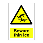
- States “Beware thin ice” in black lettering that is clearly visible to an approaching person.
- Includes a standard illustration in black for thin ice upon a reflective yellow background.
- Conforms to the following illustration:
- Limit the effects of the aerator to a distance that does not:
- Exceed 150 feet from the shoreline.
or - Extend beyond the boundaries of the property owner’s riparian zone.
- Exceed 150 feet from the shoreline.
- Operate the aerator to accomplish the following:
- Minimize the disturbance of bottom sediments.
And - Not diminish water clarity.
- Minimize the disturbance of bottom sediments.
- Operate the aerator so that it does not infringe on the recreational usage of the landowners or the public.
- Operate the aerator so that it does not remove more than 625 feet of lake vegetation.
- Additionally, the aerator should be:
- Readily inoperable or removable.
And - Secure from movement caused by water or wind.
- Readily inoperable or removable.
312 IAC 11-3-1.2 General licenses for aerators
Article 11. Public Freshwater Lakes
Authority: IC 14-10-2-4; IC 14-15-7-3; IC 14-26-2-23
Affected: IC 14-15; IC 14-26-2
Boat lifts, hoists, and shelters are considered temporary structures under the Lake Preservation Act. A temporary structure is defined as a structure that can be installed and removed from the waters of a public freshwater lake without using a crane, bulldozer, backhoe, or similar heavy or large machinery.
Boat lifts, hoists, and shelters must include the following:
- Have a canvas top and sides.
- Be supported by auger poles or other poles that do not exceed 3½ inches in diameter.
- Must not be mounted in or comprised of concrete or cement.
- Is designed to float or rest upon the bed of the lake under its own weight.
- Must not be wider than ten feet nor longer than 20 feet.
312 IAC 11-2-25 “Temporary Structure” defined
Article 11. Public Freshwater Lakes
Authority: IC 14-10-2-4; IC 14-15-7-3; IC 14-26-2-23
Affected: IC 14-15; IC 14-26-2
A Dry Hydrant is defined as a structure that does both of the following:
- Extends lakeward of the legally established or average normal waterline or shoreline.
- Provides a means of suction water supply without direct drafting for fire protection.
To qualify for the general license, the structure must satisfy each of the following requirements:
- Be sponsored or owned by a volunteer or full-time fire department recognized by the public safety training institute.
- Be readily accessible from an all-weather road, public access site, or similar area.
- Have a diameter of at least six inches.
- Be constructed of PVC pipe or a similar nontoxic material.
- Extend no more than 150 feet from the waterline or shoreline.
- Have all portions of the hydrant and its in-lake accessories be at least five feet below the legally established or average normal water level.
- Be marked with a danger buoy, which conforms to 312 IAC 5-4-6(a)(1), at the lakeward end of the hydrant.
- Be equipped with a screen or straining device on the lakeward end.
- Glacial stone or riprap only may be placed in or on the lakebed for either of the following:
- Bedding the intake pipe.
- Straining the intake water.
10. Be approved by the riparian landowner.
312 IAC 11-3-1 General licenses for dry hydrants
Authority: IC 14-10-2-4; IC 14-15-7-3; IC 14-26-2-23
Affected: IC 14-15; IC 14-26-2
The Lake Preservation Act defines glacial stone as rounded stone that satisfies each of the following:
- Produced by glacial activity.
- No individual stone weighs more than 120 pounds.
- At least 90% of the material passes through a 12-inch sieve.
- Not more than 10% of the material passes through a six-inch sieve.
IAC 11-2-11 "Glacial stone" defined
A reface is defined as the reinforcement of an existing seawall along the lakeward face.
312 IAC 11-2-22 “Seawall reface” defined Article 11. Public Freshwater Lakes
To qualify for the General License for a glacial stone reface each of the following must be satisfied:
- The seawall reface must be comprised exclusively of glacial stone.
- The reface must not extend more than four feet lakeward of the shoreline or water line at the base of a lawful seawall.
- A walk or structural tie must not be constructed on the existing seawall in combination with the glacial stone reface.
- An impermeable material must not be placed behind or beneath the glacial stone reface.
- Filter cloth placed behind or beneath the glacial stone reface must be properly anchored to prevent displacement or flotation.
- Erosion from disturbed areas landward of the shoreline or water line must be controlled to prevent its transport into the lake.
IAC 11-3-1.2 General licenses for glacial stone reface
Article 11. Public Freshwater Lakes
Authority: IC 14-10-2-4; IC 14-15-7-3; IC 14-26-2-23
Affected: IC 14-15; IC 14-26-2
The Lake Preservation Act states that the natural resources and natural scenic beauty of Indiana's public freshwater lakes are a public right and any activity that occurs at or lakeward of a public freshwater lake's legal or average normal shoreline requires the written authorization of the department prior to project initiation. However, a general license exists to exempt specific activities from licensing if they meet specific conditions that will not infringe on public rights. A temporary pier may qualify for a general license if the project meets the criteria for a temporary structure. If the criteria below are met, you are not required to submit a permit application or contact the DNR Division of Water before starting the project or after completing the project.
In order for a temporary structure to qualify, the structure must satisfy each of the following:
- Be easily removable.
- Not infringe on the access of an adjacent landowner to the public freshwater lake.
- Not unduly restrict navigation.
- Not be unusually wide or long relative to similar structures within the vicinity of the same public freshwater lake.
- Not extend more than 150 feet from the shoreline or water line. See diagrams below for additional details.
- Not be a marina.
- Not be a group pier.
- Be placed by a riparian owner or with the written approval of a riparian owner.
Illustrations of maximum lengths for a pier or similar structure that may qualify are as follows:
- Where the water depth is six feet or less from the shoreline to 150 feet from the shoreline, the maximum pier length is 150 feet.

- Where the maximum water depth is continuously more than six feet beyond 75 feet from the shoreline, the maximum pier length is 75 feet.

- Where the maximum water depth is not continuously over six feet from the shoreline, the maximum pier length is 150 feet.
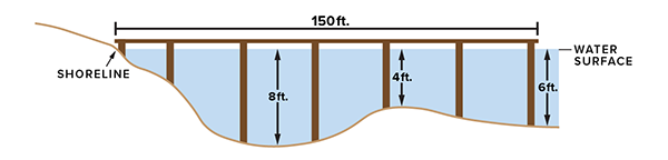
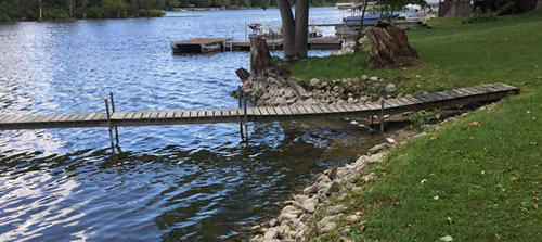
See below for photo examples of qualifying temporary piers.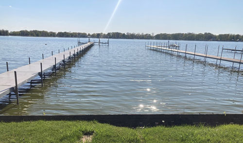
312 IAC 11-3-1 General license for temporary piers
Article 11. Public Freshwater Lakes
Authority: IC 14-10-2-4; IC 14-15-7-3; IC 14-26-2-23
Affected: IC 14-15; IC 14-26-2.
NOTE: Indiana’s boating rules (312 IAC 5) allow for temporary piers placed under the general license to extend up to 250 feet for Clear Lake in Steuben County, and up to 300 feet for Bass Lake in Starke County and certain areas of Lake of the Woods in Marshall County if the pier does not extend over water that is continuously more than 3 feet deep and otherwise follows the criteria listed. For more information on the extended pier length allowed on certain lakes, refer to Boating on Public Waters rules (312 IAC 5) or 312 Indiana Administrative Code.
Exemptions
The following lakes are exempt from the permitting requirements of the Lake Preservation Act (IC 14-26-2). Contact the DNR Division of Water if you are unsure whether a permit is required for work at any of these or other lakes.
Lake Shafer and Lake Freeman:
- Pursuant to IC 14-26-2-15; the Department may not regulate or interfere with alterations to the shoreline of or construction on impoundments of the Tippecanoe River that are formed by a dam or control structure owned and operated by a public utility for the generation of hydroelectric power. However, if the proposed project is within a floodway, a permit from our office may be required. You can view floodway locations on our website on the Indiana Floodplain Information Portal webpage. In addition, if the proposed project is located within 150 feet of a dam, please contact the DNR for coordination because it may require approval from our office.
Wolf Lake and Lake George:
- Pursuant to IC 14-26-2-3 and 312 IAC 11-2-17, the term freshwater lake does not include a lake lying wholly or in part within the corporate boundaries of any of the 3 cities having the largest population of more than four hundred thousand (400,000) but less than seven hundred thousand (700,000). Therefore, approval under the Lakes Preservation Act is not required for projects on Wolf Lake and Lake George in Hammond.
Other Exemptions:
- A lake used for, or created by, surface coal mining
- An off-stream, privately owned pond, lake, reservoir, or other body of water constructed for the reduction or control of pollutants or cooling before discharge into public waters
- A lake lying wholly or in part within the corporate boundaries of any of the three cities having the largest population of more than 400,000 but less than 700,000
- Dredging projects and shoreline restoration and/or stabilization projects within the 100-year flood level of a water supply reservoir
An exemption granted under the Lake Preservation Act does not circumvent any other State, federal, or local permitting requirement. Work within 150 feet of a dam requires coordination and possible approval from our office. The responsibility to obtain all other permits rests solely with the applicant.
312 IAC 11-2-17 "Public freshwater lake" defined
Article 11. Public Freshwater Lakes
Authority: IC 14-10-2-4; IC 14-15-7-3; IC 14-26-2-23
Affected: IC 14-15; IC 14-26-2
Construction in a Floodway
The Flood Control Act regulates various development activities (e.g. structures, obstructions, deposits, and/or excavations) within the floodway of any stream with a drainage area of one square mile or greater by requiring DNR approval prior to the beginning of the project. However, there are certain exemptions and general licenses that may apply. Read below for details.
Projects that take place on navigable waterways have different rules compared to projects that take place on non-navigable waterways. A roster of waterways that have been declared navigable or non-navigable can be viewed on the Navigable Waterways Roster webpage within the Natural Resources Commission website.
To view floodway boundaries, please visit the Indiana Floodplain Information Portal (INFIP). If you are unsure whether your project is within the Department's jurisdiction, please contact our office at 317-232-4160 or water_inquiry@dnr.IN.gov.
General Licenses
Gold prospectors are required to follow the rules under the general license to legally pan for gold. Specifically, the Gold Prospecting Rules brochure outlines what can be done without a permit. We recommend you comply with the general license outlined in the brochure. If you comply with the general license, you do not need a Construction in a Floodway permit – the general license acts as your permit. It’s important to note that the general license does not give you the right to trespass. You must get permission to access the area in addition to following the general license. Properties such as state forests, national forests, and state wildlife properties may require an additional permit, so contact them prior to prospecting on state lands. You will notice that the rules are slightly different on Navigable Waters; you can check the Navigable Waterways roster here.
If you plan to do anything outside of what's allowed under the general license (as explained in the brochure), you can apply for a Construction in a Floodway permit for gold panning. However, this process will require you to submit an application form, fee, and associated plans. Note that a permit application would need to be submitted for each location where you plan to pan for gold and that the processing time to review the application is typically several months. If needed, more information about our permitting process can be found on the Permit Programs webpage.
More information about gold prospecting can be found on our Recreational Gold Prospecting webpage.
An outfall structure is a closed conduit used to transport surface run-off into a waterway. There are thousands of these structures in the state and more are constructed every year.
DNR Water has created the following general license to allow these structures to be completed without a full permit as long as the following conditions are met:
- Tree removal and brush clearing shall be contained and minimized within the outfall project area. No more than one acre of trees shall be removed within the floodway.
- Construction activities within the waterway from April 1 through June 30 shall not exceed a total of two calendar days.
- Best management practices shall be used during and after construction to minimize erosion and sedimentation.
- Following the completion of construction, disturbed areas shall be reclaimed and revegetated.
- Disturbed areas with slopes of three to one (3:1) or steeper, or areas where run-off is conveyed through a channel or swale, shall be stabilized with erosion control blankets or suitable structural armament.
- Areas in the vicinity of concentrated discharge points shall be protected with structural armament to the normal water level of the waterway. Any riprap must have an average minimum diameter of six inches and extend below the normal water level.
- The size of the outfall project shall not exceed any of the following dimensions:
- Ten square feet in cross-sectional flow area as determined by the summation of cross-sectional area of conduits within the project area for an outfall structure.
- Five feet deep as determined by the difference in elevation between the lowest bank elevation and the bottom of the swale for an outfall structure.
- An area of disturbance 30 feet wide.
- Adequate cover shall be provided to ensure the structural integrity of the outfall conduit and to allow suitable vegetative growth.
- Within the project area, the post-construction ground surface elevation shall be less than six inches above the preconstruction elevation.
- The outlet structure shall:
- be supported by a headwall, slopewall, or anchored end section; and
- conform to the bank of the waterway.
- If flow passing through the outfall project in a reverse direction would induce flood damages during a regulatory flood, the outfall project shall be equipped with a closure mechanism.
- Construction debris and material not used as backfill shall be removed from the floodway.
In addition to the criteria above, for an outfall project to qualify for the general license the following additional criteria must be met:
- The project must not take place within a river or stream listed in the Indiana Register at 16 IR 1677 in the Outstanding Rivers List for Indiana unless prior written approval from the DNR Division of Fish & Wildlife’s Environmental Unit is obtained. The Outstanding Rivers List can be found on the Natural Resources Commission’s website. Contact the Division of Fish & Wildlife’s Environmental Unit to obtain prior written approval if pursuing the general license for a utility line crossing or outfall project within a waterbody on the Outstanding River List.
- The project must not take place within a salmonid stream designated under 327 IAC 2-1.5-5(a)(3), which reads as follows:
Where natural temperatures will permit, surface waters shall be capable of supporting put-and-take trout fishing. All waters capable of supporting the natural reproduction of trout shall be so maintained. The following waters are designated as salmonid waters and shall be capable of supporting a salmonid fishery:
- Trail Creek and its tributaries downstream to Lake Michigan.
- East Branch of the Little Calumet River and its tributaries downstream to Lake Michigan via Burns Ditch.
- Salt Creek above its confluence with the Little Calumet River.
- Kintzele Ditch (Black Ditch) from Beverly Drive downstream to Lake Michigan.
- The Galena River and its tributaries in LaPorte County.
- The St. Joseph River and its tributaries in St. Joseph County from the Twin Branch Dam in Mishawaka downstream to the Indiana/Michigan state line.
- The Indiana portion of the open waters of Lake Michigan.
- Those waters are designated by the Indiana department of natural resources for put-and-take trout fishing.
Refer to the Indiana Fish Stocking page for a listing of put-and-take trout fishing locations. 327 IAC 2-1.5-5(a)(3).
- The project must not take place within a natural, scenic, or recreational river or stream designated under 312 IAC 7-2; these include:
- Blue River – Harrison, Crawford, and Washington counties
- Cedar Creek – Allen and DeKalb counties
- Wildcat Creek – Tippecanoe and Carroll counties
Further details can be found in 312 IAC 7-2.
- The general license for a utility line crossing or outfall project does not apply if the project requires an individual permit from the United States Army Corps of Engineers under Section 404 of the Clean Water Act or Section 10 of the Rivers and Harbors Act.
312 IAC 10-5-8 Qualified outfall projects; general license page 27-28
Article 10. Floodplain Management
Authority: IC 14-10-2-4; IC 14-28-1-5
Affected: IC 14-28-1; IC 14-29-1
A utility line crossing is defined as a utility line that crosses the waterway in a straight line at an angle of between forty-five (45) degrees and one hundred thirty-five (135) degrees from the streambank and does not parallel the waterway for more than fifty (50) feet in the floodway before crossing unless the parallel portion of the line is contained within the existing road right-of-way.
The utility line general license allows utility work without notice to DNR Water. This general license was created to allow property owners and contractors to follow general guidelines for approval instead of completing the entire permit process.
The following conditions must be met:
- Tree removal and brush clearing shall be contained and minimized within the utility line crossing area. No more than one acre of trees shall be removed within the floodway.
- Construction activities within the waterway from April 1 through June 30 shall not exceed a total of two calendar days.
- Best management practices shall be used during and after construction to minimize erosion and sedimentation.
- Following the completion of construction, disturbed areas shall be reclaimed and revegetated.
- Disturbed areas with slopes of three to one (3:1) or steeper, or areas where run-off is conveyed through a channel or swale, shall be stabilized with erosion control blankets or suitable structural armament.
- No pesticide will be used on the banks.
- If a utility line transports a substance that may cause water pollution as defined in IC 13-11-2-260, the utility line will be equipped with an emergency closure system.
- If a utility line is placed beneath the bed of a river or stream, the following conditions must be met:
- A cover of at least three feet measured perpendicularly to the utility line is provided between the utility line and the banks.
- If the placement of a utility line is not subject to regulation under IC 14-28-1-29, IC 14-33, or IC 36-9-27, cover is provided as follows:
- At least three feet, measured perpendicularly to the utility line, between the lowest point of the bed and the top of the utility line or its encasement, whichever is higher if the bed is composed of unconsolidated materials.
- At least one foot, measured perpendicularly to the line, between the lowest point of the bed and the top of the utility line or its encasement, whichever is higher if the bed is composed of consolidated materials.
- If the placement of the utility line is subject to regulation under IC 14-28-1-29, IC 14-33, or IC 36-9-27, cover is provided as follows:
- At least three feet, measured perpendicularly to the utility line, between the design bed and the top of the line or its encasement, whichever is higher if the bed is composed of unconsolidated materials.
- At least one foot, measured perpendicularly to the line, between the design bed and the top of the line or its encasement, whichever is higher if the bed is composed of consolidated materials.
- Negative buoyancy compensation is provided where the utility line has a nominal diameter of at least eight inches and transports a substance having a specific gravity of less than one.
- If a utility line is placed above the bed of a river or stream, the following conditions must be met:
- Except as provided in clauses (B) and (C), minimum clearance is provided from the lowest point of the utility line (determined by the temperature, load, wind, length of span, and type of supports that produce the greatest sag) calculated as the higher of the following:
- Twelve and one-half (12½) feet above the ordinary high watermark.
- Three (3) feet above the regulatory flood elevation.
- If the river or stream is a navigable waterway that is subject to IC 14-28-1, the utility line that crosses over the waterway must be placed to provide the greater of the following:
- The minimum clearance is required under clause (A).
- The minimum clearance required for the largest boat that is capable of using the waterway. The utility must consult in advance with the department to determine the minimum clearance for boats at the crossing.
- If a utility line is attached to or contained in the embankment of an existing bridge or culvert, no portion of the utility line or its support mechanism may project below the low structure elevation or otherwise reduce the effective waterway area.
- A utility line placed in a dam or levee regulated under IC 14-27-7 does not qualify for a general license under this subsection.
(c) A person who elects to act under this section must comply with the general conditions under subsection (b). Failure to comply with these terms and conditions may result in the revocation of the general license, a civil penalty, a commission charge, and any other sanction provided by law for the violation of a license issued under IC 14-28-1 and, if the waterway is navigable, the violation of a license issued under IC 14-29-1.
- Except as provided in clauses (B) and (C), minimum clearance is provided from the lowest point of the utility line (determined by the temperature, load, wind, length of span, and type of supports that produce the greatest sag) calculated as the higher of the following:
In addition to the criteria above, for a utility line crossing project to qualify for the general license the following additional criteria must be met:
- The project must not take place within a river or stream listed in the Indiana Register at 16 IR 1677 in the Outstanding Rivers List for Indiana unless prior written approval from the DNR Division of Fish & Wildlife’s Environmental Unit is obtained. The Outstanding Rivers List can be found on the Natural Resources Commission’s website. Contact the Division of Fish & Wildlife’s Environmental Unit to obtain prior written approval if pursuing the general license for a utility line crossing or outfall project within a waterbody on the Outstanding River List.
- The project must not take place within a salmonid stream designated under 327 IAC 2-1.5-5(a)(3), which reads as follows:
Where natural temperatures will permit, surface waters shall be capable of supporting put-and-take trout fishing. All waters capable of supporting the natural reproduction of trout shall be so maintained. The following waters are designated as salmonid waters and shall be capable of supporting a salmonid fishery:
- Trail Creek and its tributaries downstream to Lake Michigan.
- East Branch of the Little Calumet River and its tributaries downstream to Lake Michigan via Burns Ditch.
- Salt Creek above its confluence with the Little Calumet River.
- Kintzele Ditch (Black Ditch) from Beverly Drive downstream to Lake Michigan.
- The Galena River and its tributaries in LaPorte County.
- The St. Joseph River and its tributaries in St. Joseph County from the Twin Branch Dam in Mishawaka downstream to the Indiana/Michigan state line.
- The Indiana portion of the open waters of Lake Michigan.
- Those waters are designated by the Indiana department of natural resources for put-and-take trout fishing.
Refer to https://www.in.gov/dnr/fish-and-wildlife/fishing/indiana-fish-stocking/ for a listing of put-and-take trout fishing locations. 327 IAC 2-1.5-5(a)(3).
- The project must not take place within a natural, scenic, or recreational river or stream designated under 312 IAC 7-2; these include:
- Blue River – Harrison, Crawford, and Washington counties
- Cedar Creek – Allen and DeKalb counties
- Wildcat Creek – Tippecanoe and Carroll counties
Further details can be found in 312 IAC 7-2.
- The general license for a utility line crossing or outfall project does not apply if the project requires an individual permit from the United States Army Corps of Engineers under Section 404 of the Clean Water Act or Section 10 of the Rivers and Harbors Act.
312 IAC 10-5-4 Qualified utility line crossings; general license page 21
Article 10. Floodplain Management
Authority: IC 14-10-2-4
Affected: IC 13-11-2-260; IC 14-27-7; IC 14-27-7.5; IC 14-28-1-29; IC 14-33; IC 36-9-27
According to 312 IAC 10-2-45, a “wetland restoration measure” is defined as a practice or combination of practices to restore a degraded or filled wetland. The conversion of an unaltered wetland to another aquatic use is not included in this definition. For this general license, the project must be coordinated with United States Fish and Wildlife Service, the United States Natural Resources Conservation Service, or the department.
The placement of a wetland restoration measure is exempted from IC 14-28-1, IC 14-29-1, and 312 IAC 10-3 if the person placing the wetland restoration measure does or establishes the following:
- Provide written notification sufficient for the department to determine if the proposed activity conforms with this subsection. The department shall, within ten days (excluding Saturdays, Sundays, and legal holidays) of the receipt of the notice, raise any objection to the placement of the restoration measure as proposed. If the department raises no objection, the proposed activity is deemed qualified for the exemption. If an objection is raised, the person shall do one of the following:
- Modify the activity to satisfy the concerns raised in the objection and provide the department with another notification under this subdivision.
- File a permit application under subsection (b) for the placement of the wetland restoration measure.
- Seek administrative review of the objection under IC 4-21.5 and 312 IAC 3-1.
- Withdraw the notification and abandon the project.
- The design, construction, and maintenance of the measure will not, considering its individual and cumulative effects, do any of the following:
- Adversely affect the efficiency of, or unduly restrict the capacity of the floodway.
- Constitute an unreasonable hazard to the safety of life or property.
- Resulting in unreasonable detrimental effects on fish, wildlife, or botanical resources.
- For a navigable waterway, be contrary to IC 14-29-1-8(c) or 312 IAC 6.
- The measure will be constructed under the direction of, or coordinated with, the United States Fish and Wildlife Service, the United States Natural Resources Conservation Service, or the department.
- The measure does not obstruct more than five percent of the cross-section of the flood plain during a regulatory flood.
- The measure will not remove more than one acre of forest.
- Following the completion of construction, disturbed areas will be reclaimed and revegetated. Disturbed areas will be mulched with straw, wood fiber, or other suitable material. To prevent erosion until revegetated species are established, mulch shall be anchored by crimping, tackifers, netting, or erosion control blankets. To the extent practicable, revegetation must restore species native to the site. If revegetation with native species is not practicable, revegetation shall be performed by planting a mixture of:
- red clover;
- orchard grass;
- perennial rye grass;
- brome grass; or
- another species approved by the department as being suitable to site and climate conditions.
- Any excavation that blocks a drain tile does not permanently alter the natural ground elevation.
- The streamward toe of a constructed berm or levee is at least 100 feet landward from the top of the bank of the waterway.
- The construction of a berm or levee is limited to one side of the waterway and where there is no other berm or levee within 2,000 feet on the same waterway.
- The elevation of a berm or levee is no more than two feet higher than the natural ground surface measured at the lowest point along the berm or levee.
312 IAC 10-5-1 Wetland restoration measures
Article 10. Floodplain Management
Authority: IC 14-10-2-4; IC 14-28-1-5
Affected: IC 4-21.5; IC 14-28-1; IC 14-29-1-8
Exemptions
Pursuant to section 22.5 of the Flood Control Act (IC 14-28-1-22.5), a person is not required to obtain a permit to construct an agricultural fence in a floodway.
"Agricultural fence," for purposes of IC 14-28-1-22.5, means a structure that is primarily used to keep animals in or out of an area that does not obstruct the flow of water or debris through a floodway.
Pursuant to section 22.5 of the Flood Control Act (IC 14-28-1-22.5), subsections (e) and (f), a person may construct a new stream crossing without obtaining a permit from the DNR Division of Water if the criteria listed below are met.
Subsection (e): Subject to subsection (f), a person is not required to obtain a permit to construct a stream crossing in a floodway if the following requirements are met:
(1) The stream has a drainage area of not more than five (5) square miles.
(2) The floodway is not a Federal Emergency Management Agency published floodway.
(3) The stream crossing is:(A) used for agricultural or residential purposes; and
(B) located in an area outside:(i) the corporate boundaries of a consolidated city or incorporated city or town; and
(ii) the territorial authority for comprehensive planning established under IC 36-7-4-205(b).(4) The stream crossing does not:*
(A) adversely affect the efficiency of or unduly restrict the capacity of the floodway;
(B) constitute an unreasonable hazard to the safety of life or property; and
(C) result in unreasonably detrimental effects to fish, wildlife, or botanical resources.
*Definitions for 4A, 4B, and 4C are defined in the floodplain management rules (312 IAC 10) as follows:
4A:
312 IAC 10-2-3 "Adversely affect the efficiency of, or unduly restrict the capacity of, the floodway" defined
Sec. 3. "Adversely affect the efficiency of, or unduly restrict the capacity of, the floodway" means an increase in the elevation of the regulatory flood of at least fifteen-hundredths (0.15) of a foot as determined by comparing the regulatory flood elevation under the project condition to that under the base condition. This definition does not, however, apply to any of the following:
(1) A dam regulated under IC 14-27-7 and IC 14-28-1.
(2) A flood control project authorized under IC 14-28-1-29.
(3) An area for which a flood easement is secured and recorded with the county recorder.
4B:
312 IAC 10-2-40 "Unreasonable hazard to the safety of life or property" defined
Sec. 40. "Unreasonable hazard to the safety of life or property" means a condition that is likely to: (1) be caused by the design or construction of a project; and (2) result during a regulatory flood in either:
(A) the loss of human life; or
(B) damage to public or private property to which the license applicant has neither ownership nor a flood easement.
4C:
312 IAC 10-2-39 "Unreasonable detrimental effects upon fish, wildlife, or botanical resources" defined
Sec. 39. "Unreasonable detrimental effects upon fish, wildlife, or botanical resources" means damage to fish, wildlife, or botanical resources that is found likely to occur by the director based upon the opinion of a professional qualified to assess the damage and: (1) creates a condition where recovery of the affected resources is not likely to occur within an acceptable period; and (2) cannot be mitigated through the implementation of a mitigation plan approved by the director.
Subsection (f): If an individual files a complaint with the department alleging that the person who constructed a stream crossing under this section (IC 14-28-1-22.5) did not comply with the requirements of subsection (e), the person who constructed the stream crossing shall provide the department with information to prove that the stream crossing does comply.
NOTES:
Streams located in a FEMA floodway are designated by the striped areas in blue and red. Streams located in a DNR Best Available floodway are designated by the striped areas in purple. To view the floodplain mapping, you can visit either the Indiana Floodplain Information Portal (INFIP) at infip.dnr.in.gov or the Division of Water Online Research Center (DoWORC).
If you are unsure whether the drainage area is less than five square miles, you can visit the DNR Division of Water’s Online Research Center (DoWORC) to check. Navigate to the layers tool in the upper right-hand corner and ensure the “Rivers and Streams at least 1 square mile” layer is toggled on. If needed, you can also toggle on the “Drainage less than 1 square mile” layer. Streams will appear in blue; streams less than 1 square mile will appear in gray. Clicking on a stream will note the drainage area as “DA
Pursuant to IC 14-28-1-22, subsection (b)(6), forestry operations along a waterway that has a drainage area (watershed) of 10 square miles or less may not need a permit from the DNR Division of Water under the Flood Control Act. Along these streams, if the activities of a forestry operation are conducted in compliance with the Indiana Logging and Forestry Best Management Practices Field Guide published by the Department of Natural Resources and confined to a waterway that has a watershed not greater than 10 square miles, a permit from the DNR Division of Water under the Flood Control Act is not required. The field guide can be found online at www.in.gov/dnr/forestry/grants-and-help/forestry-best-management-practices/forestry-best-management-practices/.
If construction activities in the floodway will not qualify for the exemption, formal approval from the DNR for construction in a floodway pursuant to the Flood Control Act (IC 14-28-1) will be required. A permit application form and permit application assistance manual can be obtained at https://www.in.gov/dnr/water/regulatory-permit-programs/. In addition, please contact your local Floodplain Administrator for local permit requirements.
A permit is not needed if the work complies with one of the options outlined below. Option #1 is for work occurring in a nonnavigable waterway, and option #2 is for work on a stream that has been declared navigable.
Option #1: Creek rock removal from a nonnavigable waterway; the landowner can remove up to 50 cubic yards per year per parcel if following the exemption criteria below.
Sec. 9. (a) This section establishes a permit exemption for removing creek rock from a nonnavigable waterway subject to IC 14-28-1 without notifying the department of natural resources (department). A person shall:
(1) own; or
(2) obtain written permission from a person that owns; the parcel along a nonnavigable waterway where creek rock is removed to qualify for a permit exemption without notice under this section.
(b) A person may remove creek rock from the parcel under subsection (a) without a written license under IC 14-28-1 and notifying the department if the person satisfies the following conditions:
(1) Not more than fifty (50) cubic yards of creek rock is removed in a calendar year from the parcel.
(2) The creek rock is removed exclusively:
(A) by hand;
(B) by using a hand tool; or
(C) with scoop-type excavating equipment.
Using a bulldozer or rock crusher does not qualify as scoop-type excavating equipment under this subdivision.
(3) Except as otherwise provided in this subdivision, the creek rock is not removed beginning April 1 and ending July 1. Except for slab rock, this condition does not apply to creek rock removed from a sand bar or gravel bar and deposited during a:
(A) regulatory flood;
(B) flood greater than a regulatory flood; or
(C) flood for which the governor declares a disaster.
(4) Except for excavating a bank, the creek rock is:
(A) removed only from a sand bar or gravel bar in a nonnavigable waterway;
(B) removed during the low flow period; and
(C) removed at least one (1) foot above the normal water level.
(5) Excavated creek rock is:
(A) removed from the nonnavigable waterway and floodway; and
(B) not placed along the streambank or used as streambank protection.
(6) An access road is not constructed that will:
(A) destroy more than one-half (1/2) acre of trees in a floodway;
(B) traverse a wetland indicated on the national wetlands inventory map, unless pads are used;
(C) raise a floodplain or floodway elevation; or
(D) cross a nonnavigable waterway.
(7) Access to the location where the creek rock is removed is exclusively from one (1) side of the nonnavigable waterway.
(c) The authorization for an activity conducted under this section does not waive permit requirements of other federal, state, and local governments.
(d) Failure to comply with the conditions under subsection (b)(1) through (b)(7) may result in a revocation of the permit exemption under subsection (a), a civil penalty, a commission charge, and any other sanction imposed by law for the violation of a permit issued under IC 14-28-1.
Authority: IC 14-10-2-4; IC 14-28-1-5
Affected: IC 14-28-1
The Floodplain Management rules can be downloaded from our website at https://www.in.gov/dnr/water/statutes-and-rules/
Option #2 – Creek rock removal from a navigable waterway; general license without notice. The landowner is allowed to remove up to 10 cubic yards per year per parcel.
- Except as provided in subsection (d), this section establishes a general license for the removal of creek rock from a navigable waterway that is subject to IC 14-28-1, IC 14-29-1, or IC 14-29-3.
- To act under this section, a person must:
- if creek rock is to be removed from a parcel located in the riparian zone of an adjacent property owner, either:
- be a riparian owner for the parcel; or
- have written permission from a riparian owner for the parcel; and
- receive written permission from the department in the conduct of its responsibilities under IC 14-19-1-1(9). The permission under this subdivision is a proprietary function for the public trust and is not a licensure function
c. Without a written license under IC 14-28-1, IC 14-29-1, or IC 14-29-3, and without notice to the department other than as anticipated by subsection (b)(2), a person may remove creek rock from the parcel, if the person satisfies each of the following conditions:
- Not more than ten (10) cubic yards of creek rock is removed within one (1) calendar year from the parcel.
- The creek rock is removed exclusively by the following methods:
A. Hand.
B. Hand tools.
- The creek rock is removed between July 1 and March 31 of the following year.
- The creek rock is removed only from sand bars and gravel bars within the waterway. The excavation of waterway banks does not qualify under this subdivision.
d. An individual license is required under IC 14-28-1 and this article for the removal of creek rock from Lake Michigan.
Section 312 IAC 6-5-9 - Creek rock removal from a navigable waterway
Article 6. Navigable Waters
Authority: IC 14-10-2-4; IC 14-28-1-5; IC 14-28-1-8
Affected: IC 14-19-1-1; IC 14-28-1; IC 14-29-1; IC 14-29-3
Under Section 24.5 of the Flood Control Act (IC 14-28-1-24.5), a person may reconstruct an existing berm or levee without obtaining a permit from the DNR Division of Water if the criteria listed below are met.
- Berm or levee is located in a rural area.
- Berm or levee was constructed before January 1, 1973, with or without a permit, or after December 31, 1972, with a Flood Control Act permit issued.
- Plans and specifications for the reconstruction of the berm or levee are submitted to the DNR Division of Water that meet the following requirements prior to the start of construction; the submitter must ensure the Department is satisfied the plans meet the requirements below before starting construction:
- The height of the berm can be no more than the existing, pre-damaged berm, or what was previously permitted.
- The top width and sideslopes can be no more than the existing, pre-damaged berm dimensions, or what was previously permitted.
- The berm must be along the same alignment and footprint of the existing, pre-damaged berm or levee, or what was previously permitted.
- The berm must be constructed with similar materials used to construct the existing, pre-damaged berm, or what was previously permitted.
- Within six months after the reconstruction of the berm or levee is complete, submit documentation from a surveyor or professional engineer licensed in Indiana that the berm or levee has been reconstructed in accordance with the plans previously submitted to the department.
If the proposal does not meet the requirements above, then a Construction in a Floodway permit application must be filed with the DNR. A permit issued for this construction is valid for two years and may be renewed for one additional two-year period. A permit can be submitted on our Permit Program page. The DNR may incorporate in and make a part of a permit the conditions and restrictions considered necessary for the purposes of the Flood Control Act. However, if a berm or levee was originally constructed under a qualified entity or authority (listed below), the DNR shall not require or recommend mitigation for the removal of any trees or woody vegetation from the top or side slopes, or within 10 feet of the toe; if the berm or levee was constructed prior to January 1, 1973; or from the top, side slopes, or toe of the design footprint of the berm or levee if it was previously permitted.
Qualified Entity or Authority includes the following:
- Conservancy Districts
- Levee Districts and Associations
- Levee Associations
- Levee Authority in Vanderburgh County
- Flood Control Projects
- River Basin Commissions
NOTE: If conditions at the site of the berm or levee have deteriorated to the point that the berm or levee should be abandoned and reconstructed in another location, the footprint of the abandoned berm or levee, including areas within 10 feet of the toe, shall be credited to any mitigation required for the construction of the new berm or levee.
The log jam removal exemption allows for a landowner to remove a logjam or wood debris from a waterway if certain conditions are met.
Please see our Log Jam Removal Guide for more details: Log Jam Removal Guide, IC 14-28-1-22 (b) (6)
Certain reconstruction and maintenance projects conducted by county drainage boards can be exempt from permitting under the Flood Control Act (IC 14-28-1) and the Lowering of Ten Acre Lakes (“Ditch”) Act (IC 14-26-5). For the Flood Control Act, IC 14-28-1-22 exempts a “reconstruction” or “maintenance” project (as defined in IC 36-9-27) on a stream or an open regulated drain if the total length of the stream or open drain is not more than 10 miles.
- "Total length" means the length of the stream, expressed in miles, from the confluence of the stream with the receiving stream to the upstream or headward extremity of the stream, as indicated by the solid or dashed, blue or purple line depicting the stream on the most current edition of the seven and one-half (7 1/2) minute topographic quadrangle map published by the United States Geological Survey, measured along the meanders of the stream as depicted on the map.
- "Maintenance" means work on a drain as described in section 34(c) of the Drainage Law for any of the purposes stated in that section. "Reconstruction" means work on a drain as described in section 34(b) of the Drainage Law to correct any of the problems with the drain that are enumerated in that section up to and including the discharge portion of the drain. Both of these subsections can be viewed here.
Note that this exemption only applies to county surveyors doing the work or representatives doing work on behalf of the county drainage board. Individuals working on a county drain, even with permission from the county drainage board, are not eligible for the permitting exemption.
County drainage board projects exempt from permitting under the Flood Control Act may still need to request an on-site field review of the project. A formal early coordination procedure for drainage board projects was established by the creation of Section 53.5 of the Indiana Drainage Code (IC 36-9-27) in 1995. Section 53.5 states that if a reconstruction or maintenance project is subject to regulation under the Flood Control Act or the Lowering of Ten Acre Lakes Act, or if it requires an individual permit from the U.S. Army Corps of Engineers under Section 404 of the federal Clean Water Act, the county surveyor or drainage board shall request an on-site field review of the project. County Surveyors can initiate this process by contacting the Statewide Biologist, Nick Haunert, in the DNR Division of Fish & Wildlife at nhaunert@dnr.IN.gov.
The floodplain management rules, under 312 IAC 10-4-2, outline certain activities that do not require a permit from the DNR Division of Water. These include the maintenance of crops, pastures, and lawns. Any existing farmland can continue to be farmed without the need for approval from our office. Similarly, lawns and pastures can be maintained without approval from our office. If land is being converted from one use to another and/or if there is proposed excavation, fill, grading, or other development or construction of a structure, prior approval from our office should be obtained.
312 IAC 10-4-2 Categorical floodway licensing exemptions
Authority: IC 14-28-1-5; IC 14-28-3-2
Affected: IC 14-28-1; IC 14-28-3
Sec. 2. Development and maintenance of the following activities are exempted from IC 14-28-1 and this article unless the activities involve the placement of a structure, obstruction, deposit, or excavation:(1) Crops.
(2) Pastures.
(3) Forests.
(4) Park and recreational uses.(Natural Resources Commission; 312 IAC 10-4-2; filed Jul 5, 2001, 9:12 a.m.: 24 IR 3392, eff Jan 1, 2002; readopted filed Jul 21, 2008, 12:00 p.m.: 20080813-IR-312080072RFA)
Link: http://iac.iga.in.gov/iac/T03120/A00100.PDF; page 18
Rural state and county bridge projects: IC 14-28-1-22 (b)(2) exempts certain state and county highway bridge projects from permitting requirements under the Flood Control Act.
IC 14-28-1-22(b)(2) exempts certain state or county highway bridge projects described in the following paragraph from the permitting requirements of the DNR Division of Water. “(2) A construction or reconstruction project on a state or county highway bridge in a rural area that crosses a stream having an upstream drainage area of not more than fifty (50) square miles and the relocation of utility lines associated with the construction or reconstruction project if confined to an area not more than one hundred (100) feet from the limits of the highway construction right-of-way.”
In order for a bridge project to be exempt from the permit requirements, it must meet all of the following criteria:
- Be a state or county highway department project;
- Be a bridge (span structure, culverts, etc.);
- Be located in a rural* area; and
- Cross a stream having an upstream drainage area of less than fifty (50) square miles.
*Rural area is defined as an area:
- Where the lowest floor elevation, including basement, of any residential, commercial, or industrial building impacted by the project is at least two (2) feet above the base flood elevation with the project in place;
- Located outside the corporate boundaries of a consolidated or incorporated city or town; and
- Located outside of the territorial authority for comprehensive planning (generally a two (2) mile planning buffer around a city or town).
All construction associated with the rural bridge within the project right-of-way are considered part of this exemption. This includes activities such as bank protection, spoil disposal, borrow pits, etc.
This exemption has been misunderstood and liberally applied in the past. If challenged, it will be the responsibility of the person claiming the exemption to prove to the DNR Division of Water that all 4 criteria have been satisfied.
Note: This exemption only applies to the Flood Control Act (IC 14-28-1). If a bridge is to be constructed over a navigable waterway, or over or near a public freshwater lake, a permit may be required under the Navigable Waterways Act (IC 14-29-1), the Lowering of the Ten Acre Lake Act (IC 14-26-5) or the Lake Preservation Act (IC 14-26-2).
Rural Bridge Exemption to IC 14-28-1
IC-14-28-1-22(b)(2)
312 IAC 10-5-13 Streambank protection in floodway; permit exemption with notice
Sec. 13. (a) This section establishes a permit exemption with notice to the department of natural resources (department) to place streambank protection in a floodway.
(b) Except as provided in subsection (c), a person may place streambank protection in a floodway with a permit exemption under subsection (a) to reconstruct, repair, and control or prevent erosion of the streambank using:
(1) vegetative stabilization;
(2) bioengineered materials;
(3) glacial stone;
(4) riprap; or
(5) any combination of bank stabilization techniques that meet the following criteria:(A) The location of the streambank protection is in a rural area that lies outside the:
(i) corporate boundaries of a consolidated city, or an incorporated city or town; and
(ii) territorial authority for comprehensive planning established under IC 36-7-4- 205(b).(B) The total activity is not more than three hundred (300) feet.
(c) A person shall obtain a written license from the department to place streambank protection in a salmonid stream designated under 312 IAC 6.2-1-2(13), or in a natural, scenic, or recreational river or stream designated under 312 IAC 7-2, before beginning placement of the streambank protection.
(d) A person that wishes to conduct streambank protection under this section shall file a written notice, in a form and manner prescribed by the department, with the division of water. The notice must include the following information:
(1) Identification of the waterway and a description of the parcel where the activity will occur.
(2) The name, address, email, and telephone number of the person or authorized agent performing the streambank protection under the permit exemption with notice under subsection (a).
(3) Documentation to demonstrate the person seeking the permit exemption under subsection (a) is the owner of the property where the activity will take place, or the person was given permission from the owner as the authorized agent.
(4) Current photos of the streambank where the activity will occur.
(5) A statement of the material to be used to protect the streambank and the total length of the streambank to be protected.
(6) A statement that the owner of the property where the activity will take place, or the authorized agent performing streambank protection under the permit exemption under subsection (a), agrees to comply with the following conditions:(A) Removing a tree and clearing brush are contained and minimized in the project area. Removing a tree may not result in excavating the root ball.
(B) Construction activity in the waterway beginning April 1 and ending July 1 does not exceed two (2) calendar days.
(C) The work conforms with the existing bank at the upstream and downstream limits of the area where the activity will occur, and ties into stable areas upstream and downstream to prevent flanking.
(D) Stone may be placed from the toe of the slope to the ordinary high water mark. Bioengineered or vegetative material may be used above the ordinary high water mark.
(E) The slope of a streambank protected with riprap, glacial stone, or broken concrete is not more than 2H:1V.
(F) The average diameter of riprap used to protect a streambank is not less than six (6) inches and must extend below the normal water level.
(G) Broken concrete may be used to protect a streambank if it is unpainted and free of:(i) soil;
(ii) fine material;
(iii) metal;
(iv) bricks;
(v) blocks;
(vi) asphalt; or
(vii) other construction debris.Exposed rebar or other reinforcing material must be cut flush with the surface of the concrete and removed from the floodway. Concrete must not be contaminated with oil or other toxic substances. Broken concrete must be graded pieces not less than six (6) inches and not more than two (2) feet in any dimension.
(H) Riprap, glacial stone, or broken concrete must have a bedding layer of well graded aggregate or a geotextile to prevent piping soil underneath the stone protection underneath.
(I) A disturbed area outside the streambank protection area that is not used for agricultural production must be reseeded with a mixture of native grasses, forbs, and legumes.
(J) Best management practices must be used during and after the construction to minimize erosion and sedimentation.
(e) Not later than twenty (20) calendar days, excluding Saturdays, Sundays, and legal holidays, after receiving a notice under subsection (d), the department shall respond as follows
(1) Approve the permit exemption terms.
(2) Provide additional conditions to approve the permit exemption terms.
(3) Require additional information regarding the:(A) floodway capacity;
(B) safety of life or property; or
(C) effect on fish, wildlife, or botanical resources.(4) Require the person to obtain a written license for an activity under IC 14-28-1 or IC 14-29-1, or both.
If the department does not respond not later than twenty (20) days after receiving the notice under subsection (d), the permit exemption is approved.
(f) A permit exemption for streambank protection under this section expires not later than one hundred eighty (180) days after the person receives written approval of the permit exemption terms under subsection (e) from the department.
(g) A person that places streambank protection under a permit exemption under subsection (a) shall comply with the following:
(1) The permit exemption terms approved by the department.
(2) Additional conditions imposed on the person by the department under subsection (e) or IC 14-28- 1-22.
Failure to comply with the conditions of this section may result in the revocation of the permit exemption under subsection (a), a civil penalty, a commission charge, and any other sanction imposed by law for the violation of a license issued under IC 14-28-1 or, if the waterway is a navigable waterway, the violation of a license issued under IC 14-29-1.
Pursuant to subsection (d), and if the project conforms to criteria in subsection (b) and is not along a designated waterbody outlined in subsection (c), submit the Notification of Construction in a Floodway Under IC 14-28-1 for Streambank Stabilization (State Form 57632), along with any supporting documentation, to our office at water_inquiry@dnr.in.gov. The form can be found here: https://forms.in.gov/Download.aspx?id=16459.
Authority: IC 14-10-2-4; IC 14-28-1-5
Affected: IC 14-28-1-22; IC 14-29-1; IC 36-7-4-205
The Floodplain Management rules can be downloaded from our website at https://www.in.gov/dnr/water/statutes-and-rules/
Under the Floodplain Management rules (312 IAC 10-1-2), the floodplains subject to regulation are those along waterways having a drainage area of at least 1 square mile.
"Drainage area" is defined as “the total land area measured in a horizontal plane and enclosed by a topographic divide from which surface run-off from precipitation normally drains by gravity into a waterway above a specified location.” This may also be considered the watershed area feeding the stream at the location of interest.
Therefore, a permit is not required from the DNR Division of Water under the Flood Control Act for any work along a waterway having a drainage area of less than 1 square mile.
NOTE: If you are unsure whether the drainage area is less than 1 square mile, you can visit the DNR Division of Water’s Online Research Center (DoWORC) to check. Navigate to the layers tool in the upper right-hand corner and toggle on “Drainage less than 1 square mile”. Streams less than 1 square mile will appear in gray. Clicking on a stream will note the drainage area as “DA
312 IAC 10-5-12 Permit exemption for removing a tree from a floodway
Sec. 12. (a) This section establishes a permit exemption for removing a tree from a floodway by using hand operated equipment. A person shall:
(1) own; or
(2) obtain written permission from a person that owns; the parcel where a tree is to be removed to qualify for a permit exemption under this section.
(b) A person may not conduct the following activities under a permit exemption under subsection (a):
(1) Remove a tree along a dam or levee regulated under IC 14-27-7, IC 14-27-7.3, or IC 14-27-7.5.
(2) Except for the exposed root ball of a tree that fell from a natural disaster or storm, remove or excavate the root ball of a tree by any method.
(3) Use a material or fill to construct a temporary or permanent access road or stream crossing.
(4) Excavate or stabilize a streambank.
(5) Remove a tree from a known mitigation site. For information regarding mitigation sites, please contact the division of fish and wildlife.
(6) Except for a tree that fell from a natural disaster or storm, cut a tree suitable for Indiana bat or northern long-eared bat roosting, that is at least three (3) inches in diameter and four and one-half (4 1/2) feet in height, and:
(A) is living or dead;
(B) has loose hanging bark; or
(C) has cracks, crevices, or cavities; beginning April 1 and ending October 1.
(7) Remove a tree that:
(A) contains a bald eagle nest; or
(B) is not more than six hundred sixty (660) feet from a bald eagle nest; without a permit from the United States Fish and Wildlife Service.
(c) A person may conduct the following activities under a permit exemption under subsection (a):
(1) Cut and remove a single, isolated tree that has fallen or washed into a river or stream channel without removing the root ball by excavation.
(2) Cut a tree without removing the stump and root ball of the tree by excavation.
(3) Cut and remove, or salvage, an uprooted tree from a natural disaster or storm, including the root ball of the tree, and fill the hole left by the uprooted tree to match the existing grade.
(4) Cut a tree and grind the stump without removing the root ball by excavation, and fill the hole left by grinding the stump to match the existing grade.
(d) A person conducting an activity under subsection (c) shall satisfy the following conditions:
(1) Remove all cut trees and debris from the floodway.
(2) Perform an authorized activity under this section in a way that minimizes:
(A) erosion; and
(B) depositing sediment into a stream.
(3) Not later than fifteen (15) days after completing an activity under subsection (c), complete the following:
(A) Revegetate a bare and disturbed area with a mixture of native grasses and legumes.
(B) If necessary for erosion control and seed establishment, mulch a disturbed area with straw or wood fiber that is crimped or mixed with a tackifier or covered with a net-free or Leno woven erosion blanket. The following turf-type grasses may be used in a mowed area:(i) Low endophyte.
(ii) Friendly endophyte.
(iii) Endophyte free tall fescue.(C) Include a temporary seed mix of oats (Avena sativa) in the spring or cereal rye (Secale cereal) in the fall.
(4) Conduct a construction activity in the waterway beginning April 1 and ending July 1 that does not exceed two (2) calendar days.
(e) A person conducting an activity under this section shall comply with the conditions set forth under subsection (d). Failure to comply with the conditions set forth under subsection (d) may result in the revocation of the permit exemption under subsection (a), a civil penalty, a commission charge, and any other sanction imposed by law for the violation of a license under IC 14-28-1 and, if the waterway is a navigable waterway, the violation of a license under IC 14-29-1.
Authority: IC 14-10-2-4; IC 14-28-1-5
Affected: IC 14-27-7; IC 14-27-7.3; IC 14-27-7.5; IC 14-28-1; IC 14-29-1
The Floodplain Management rules can be downloaded from our website at https://www.in.gov/dnr/water/statutes-and-rules/
A permit under the Flood Control Act and/or the Navigable Waterways Act is not required to remove certain low head dams from a navigable waterway. As low head dams are a threat to public safety, navigability, and stream ecology, it is in the public interest to remove low head dams that are an encroachment on navigable waterways. A low head dam is considered an encroachment on a navigable waterway unless it is owned and operated by a public utility [as defined by IC 8-1-2-1(a)] or a municipally owned utility [as defined by IC 8-1-2-1(h)], or if it is owned, managed, or operated by the DNR. For any other low head dam on a navigable waterway, a permit under the Flood Control Act (IC 14-28-1) or the Navigable Waterways Act (IC 14-29-1) is not required so long as the removal will not:
(1) adversely affect the efficiency of or unduly restrict the capacity of the floodway;
(2) constitute an unreasonable hazard to the safety of life or property; or
(3) result in unreasonable detrimental effects upon fish, wildlife, or botanical resources;
A permit is still required to remove a low head dam from a non-navigable waterway and for other work to a low head dam. If needed, see more information on permitting.
NOTE: A person who intends to remove a low head dam under this exemption must still notify the DNR Division of Water at least 30 days before beginning the removal process. Send notification to the Division of Water at water_inquiry@dnr.IN.gov and include the following information:
- The name, address, telephone number, and email address of the person removing the low head dam.
- A description of the proposed activity.
- The location of the proposed activity, including appropriate mapping.
- Evidence the proposed activity meets the requirements of this exemption (items 1-3 above) according to state administrative rules.
Lake Michigan
Beach Nourishment
The Department of Natural Resources incentivizes beach nourishment activities by making it easier to get authorization to place sand on the beach. A rule was adopted to establish a general authorization for beach nourishment under 312 IAC 6-6-1 Rule 6. A person who qualifies for the general authorization may place sand for beach nourishment, either within or outside the ordinary high water mark (OHWM), without obtaining a navigable waterways fill permit under IC 14-29-1-8.
Instead, a letter is provided to the agency by the person wishing to use the general authorization. In the letter, the person provides information concerning the site of origin of the sand, the site of the deposit, which must be either in the Indiana Dunes State Park or the Indiana Dunes National Park (formerly known as Indiana Dunes National Lakeshore), and other pertinent information, including any testing performed on the sand. Before proceeding, permission must be obtained from either the Indiana Dunes State Park or the Indiana Dunes National Park (formerly known as Indiana Dunes National Lakeshore).
To view the guidelines for general authorization for beach nourishment to Lake Michigan, please visit our beach nourishment page.