This page gives information on INDOTs Vincennes District.
INDOT Vincennes District - Southwest Indiana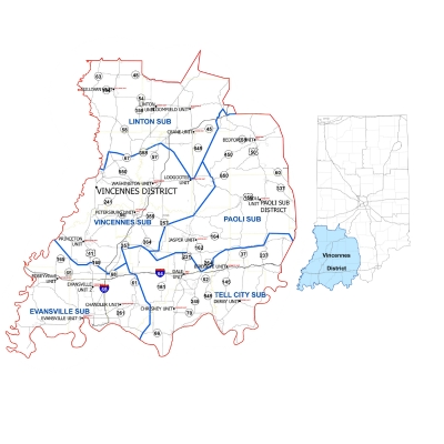
3650 South U.S. Highway 41 Vincennes, IN 47591
Vincennes District Map
Rusty Fowler, Deputy Commissioner
The Vincennes District is responsible for maintaining 4,425 lane miles of state roads, 784 lane miles of interstate, 1,849 large culverts, 20,000 small culverts, 1,085 state bridges, 142 snow routes, 260 traffic signals, 186 flashers, 57,000 road signs, and 1,310 panel signs.
There are five sub-districts (Evansville, Linton, Paoli, Tell City and Vincennes) and 17 counties (Crawford, Daviess, Dubois, Gibson, Greene, Knox, Lawrence, Martin, Orange, Perry, Pike, Posey, Spencer, Sullivan, Vanderburgh and Warrick) within the Southwest District.
USDOT Public Listening Session - EMPO Planning Process
There are two upcoming opportunities for you to talk directly with Federal Highway Administration (FHWA) and Federal Transit Administration (FTA) in meetings concerning the transportation planning process in Evansville, Indiana. The public comment sessions are scheduled as follows:
Read the full public meeting notice by clicking here.
To view all upcoming public meetings and hearings click here.
Current Projects

To find more information about current construction projects in your area, visit 511in.org.
To view documents related to future projects, click here.

Contact Us

INDOT Links
- 18 Month Letting List Search
- Adopt-A-Highway Program
- Flashing Yellow Arrow Traffic Signals
- How a Project Becomes a Project Brochure
- Indiana's Manual on Uniform Traffic Control Devices
- Local Public Agency Programs
- INDOT CARS 511 Program
- Subscribe to INDOT News