Location
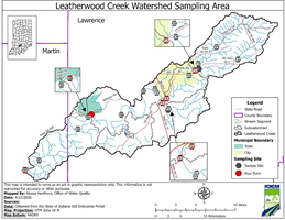
The Leatherwood Creek Watershed covers approximately 122.6 square miles in Lawrence and Martin Counties. Within the watershed, there are five subwatersheds that will be included in the Total Maximum Daily Load (TMDL) report: Headwaters, Leatherwood Creek, Sheeks Lake, Crooked Creek, and Henshaw Bend. The subwatershed Town of Bryantsville will not be sampled for this TMDL project due to an inability to find a safe, surface water sampling location. The Hydrologic Unit Code (HUC) for the Leatherwood Creek Watershed is 0512020810.
History
Past surveys of the Leatherwood Creek Watershed have been conducted as early as 1983, and may have included monitoring for fish communities, fish tissue, macroinvertebrate communities, Escherichia coli (E. coli), and/or water chemistry through several IDEM monitoring programs. Impairments currently identified in the watershed include E. coli, PCBs in fish tissue, mercury in fish tissue, and impaired biotic communities (IBC). Potential pollution sources contributing to these impairments include nonpoint sources from agricultural lands and pastures, rural run-off, wildlife, as well as point sources from straight pipe discharges and home sewage treatment systems.
Parameters To Be Addressed
IDEM will complete a comprehensive sampling program in the watershed that will be based on the current impairments. A total of 19 sites will be assessed for general chemistry, nutrients, habitat, and fish and macroinvertebrate communities. A comprehensive list of all parameters will be referenced in the approved work plan.
Timeline
- A public kickoff meeting is expected to be held summer of 2026
- A draft TMDL public meeting is expected to be held in 2027 upon completion of the draft TMDL report.
- New impairments will be determined as a result of the 2026-2027 watershed characterization study for the Leatherwood Creek watershed. The new impairments will be posted for public comment in 2028. The notice will outline the findings of the study and list proposed additions/deletions to the 2030 303(d) list of Impaired Waters.
- Additional meetings will be held as needed. Please check the IDEM calendar for updates.
The TMDL Report
The TMDL Report is anticipated to be completed in 2028.
Watershed Characterization Monitoring 2026-2027
- There is no sampling data to report at this time.