Summary
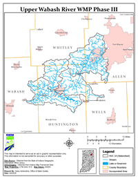
Huntington County Soil and Water Conservation District (SWCD) took it upon themselves to make updates to the Upper Wabash Phase III Watershed Management Plan (WMP). In 2017, Huntington County SWCD received a 205j grant from the Indiana Department of Environmental Management (IDEM) to write a WMP for the Upper Wabash River watershed. The Upper Wabash Phase 3 Watershed is located in portions of five counties in northeastern Indiana – Allen, Huntington, Wabash, Wells, and Whitley. The Upper Wabash Phase 3 area consists of four subwatersheds- Aboite Creek (HUC 0512010110), Clear Creek (HUC 0512010112), Little River (HUC 0512010111), and Loon Creek (HUC 0512010113).
The Phase III project area drains approximately 228,303 acres and contains over 540 miles of rivers and streams, including 25 miles of the mainstem Wabash River flowing from west of Markel, Indiana to just east of Lagro, Indiana through the Loon Creek-Wabash River watershed. The project area also includes 23 miles of the Little River flowing southwest through the Aboite-Creek Watershed from west of Ft. Wayne, Indiana to its confluence with the Wabash River in Huntington, Indiana. Other waterways within the watershed are primarily small headwater streams or drainage ditches.
Monitoring data collected during the project found that E. coli and turbidity were elevated in nearly all watersheds and nutrients were elevated at nearly all sites. Several water quality impairments are listed in the IDEM 2018 Draft 303(d) List of Impaired waters for the UWRW Phase 3 area including E. coli, nutrients, impaired biotic communities, and PCBs in fish tissue. The majority of land use in the project watershed is row crop agriculture (70%) while industrial, urban, and suburban land uses are also prevalent within the project area accounting for 16% of land use, concentrated primarily around the cities of Fort Wayne, IN and Huntington, IN. The Upper Wabash River Phase 3 WMP Update (2025) was approved by IDEM and, as a result, US Environmental Protection Agency in July 2025. The approved WMP update includes four (4) more HUC 12 watersheds identified as critical areas (Tier 3) in addition to the Tier 1 and Tier 2 critical areas identified in the 2021 version of the WMP. This will allow for the implementation of more conservation practices that will help reduce the amount of sediment and excess nutrients from entering the rivers and streams in the Upper Wabash watershed. The pollutant loading goals remain the same in the WMP update and are as follows; reduce nitrogen loads by 296.35 tons/year, phosphorus by 29.85 tons/year, and sediment by 7,742.72 tons/year. The overall project progress will be tracked using the action register as a guide for the schedule of activities to be completed throughout the future.