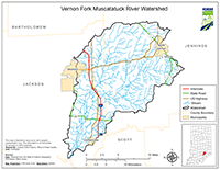
Location
The Vernon Fork Muscatatuck River Watershed covers approximately 212 square miles in Southeast Indiana and is in Jackson and Jennings counties. The six subwatersheds included in the Total Maximum Daily Load (TMDL) report are Mutton Creek, Storm Creek, Sixmile Creek, Grassy Creek, Polly Branch, and Indian Creek.
History
IDEM has conducted numerous surveys of the Vernon Fork Muscatatuck River watershed, dating as far back as 1992 with sampling on Crosley Lake. Fixed station monitoring has been conducted in the watershed since 1998. More extensive surveys of the watershed were conducted in 1993, 1997, 2002-2007, 2013, 2016, and 2017 by the probabilistic, targeted, and fish tissue monitoring programs in varying years. This includes two studies in cooperation with the U.S. Fish and Wildlife Service. Impairments in the watershed include E. coli, dissolved oxygen (DO), biological communities, and mercury (for fish tissue). Potential pollution sources in the watershed include nonpoint sources from agricultural lands and pastures, rural run-off, wildlife, as well as point sources from straight pipe discharges and home sewage treatment systems.
Parameters Addressed
IDEM completed a comprehensive sampling program in the watershed that was based on the current impairments. A total of 23 sites was assessed for general chemistry, nutrients, habitat, and fish and macroinvertebrate communities. A comprehensive list of all parameters is referenced in the approved work plan. The final TMDL report addresses E. coli, biological communities (IBC), and low dissolved oxygen (DO) impairments in the watershed.
Timeline
- A TMDL final public meeting was held on July 14, 2022 at 10:00 AM (EST) at the Jennings County Public Library to present the findings of the draft TMDL report and answer any questions.
- A virtual public kickoff meeting was held to introduce the project and solicit input on October 27, 2020 at 2:00 PM (EST).
- A public outreach event for the project was held on June 14 and June 16, 2021 from 5:30 PM - 8:00 PM at the Jennings County Fair.
- A 30-day public comment period for the draft final TMDL report occurred from July 15, 2022 through August 15, 2022. No comments were received.
- The final TMDL report was approved by U.S. EPA on September 9, 2022.
The TMDL Report
Watershed Characterization Monitoring 2020-2021
- Sampling and Analysis Work Plan for the Monitoring Project [PDF]
- Map of IDEM Monitoring Sites [PDF]
- Photos of IDEM Monitoring Sites [PDF]
- IDEM Surface Water Results Summary (Nov 2020 - Jan 2021) [PDF]
- IDEM Surface Water Results Summary (Feb 2021 - Apr 2021) [PDF]
- IDEM Surface Water Results Summary (May 2021 - Jul 2021) [PDF]
- IDEM Surface Water Results Summary (Aug 2021 - Oct 2021) [PDF]
- IDEM Fish Community Assessment Report [PDF]
- IDEM Macroinvertebrate Community Assessment Report [PDF]