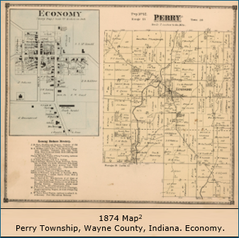
 Perry Township of Wayne County was first laid out in 1817 as one of six townships in newly organized Wayne County, one year after the founding of the State of Indiana. Its name is likely in honor of Commodore Oliver H. Perry, a naval hero of the War of 1812. It is one of 14 townships in Indiana named Perry.
In the beginning, Perry Township occupied most of northwest Wayne County but gradually lost land area to the formation of other townships: Greene Township in 1821, Clay Township in 1832, Jefferson Township in 1834, and Dalton Township in 1847. Altogether, it lost about two-thirds of its original size.1
Present day Perry Township is located in the northwest quarter of Wayne County and is one of the smaller townships in Wayne County in both area and population. The township comprises 17.44 square miles and has a population of 830 as of the 2020 Census, which includes the Town of Economy (pop 145). The township’s geographic boundaries are the Randolph County line to the north, a line defined by Macy Road and Dingle Road to the east, W.E. Oler Road and Clyde Oler Road to the south, and a line defined by Hadley Road to the west.
Economy is the only incorporated area within the township. It was platted in 1825. From Economy, it is about a 10-minute drive to Hagerstown, a 25-minute drive to Richmond, and a 35-minute drive to Muncie.
Perry Township is part of the Nettle Creek School District, along with Clay, Dalton, Harrison, and Jefferson townships. The schools are in Hagerstown. Prior to consolidation in the 1960s, Perry Township had its own schools in Economy. There are two structures remaining – the Economy gymnasium (built in 1922) and the ag/science building (now known as the Lions Club Den). Both facilities are owned by Perry Township and are available for rent.
The Perry Township Volunteer Fire Department was established in the 1920s. The firehouse is located in Economy.
1sourced from History of Wayne County, Indiana, by Andrew W. Young, published in 1872.
2map courtesy David Rumsey Map Collection, David Rumsey Map Center, Stanford University Libraries.