 317-232-2222
 Indiana Community Risk Reduction Coalition
Vast amounts of data are available via the first responder community, and the data are used to inform the true risks to all Hoosiers and create the right strategies to reduce those risks. That is the concept behind Community Risk Reduction (CRR). Data informs the CRR, which then allows for the identification of high-risk areas and behaviors that can then be targeted. Armed with this knowledge, partnerships can form effective strategies using limited resources more efficiently. Benefits of a CRR strategy: identifies new and emerging hazards, addresses underserved communities and changing community demographics, improves Insurance Services Office (ISO) ratings, offsets declining budgets of fire and local governments, helps with accreditation.
Vision 20/20, a national organization with expertise in CRR efforts in the fire service, is working closely with the Indiana Community Risk Reduction Coalition to improve data collection from fire and EMS agencies across the state. Indiana is currently conducting a statewide risk assessment (SRA). Once the SRA is complete, the coalition will begin the “Identify Risks” stage of the CRR process. The risks will be prioritized and plans will be drafted to address those risks for each community. The data analysis will culminate in several mitigation strategies and tactics to address risk factors in communities across the state. Contact Rob Miller at rmiller2@dhs.in.gov to learn more about the CRR effort or get involved.
Updates
Using the Indiana Geocoder and Mile Marker Data

Data Reporting Affects Grants
Reporting data affects grant funding for fire departments. State legislators in 2022 passed HEA 1314, which requires fire departments to report their emergency response data annually (Section 41). If a fire department fails to do so, it may be ineligible to receive certain grants administered by IDHS. Read HEA 1314 details
Fire Incident Data
EMS Incident Data
Residential Fire Fatalities
Open Fire Fatalities DashboardResidential Fire Fatalities
Community Partners
Open Community PartnersCommunity Partners
Training Opportunities
Open Training OpportunitiesTraining Opportunities
Tools and Education Resources
Open Tools and Education ResourcesTools and Education Resources
Highlighted Data
Additional Data
IDHS Fire Investigations
| Fire Investigation Type | Cases by Year | ||||
|---|---|---|---|---|---|
| 2024 | 2023 | 2022 | 2021 | ||
| Residential | 499 | 464 | 401 | 342 | |
| Commercial | 74 | 71 | 76 | 59 | |
| Vehicle | 56 | 30 | 32 | 19 | |
| Other | 129 | 124 | 88 | 92 | |
| Consultation | 6 | 11 | 7 | 12 | |
| Notification | 46 | 50 | 47 | 42 | |
| Assist and Cell Warrants | 83 | 76 | 41 | 71 | |
Indiana Residential Fire Fatalities Map
Find where deaths have occurred in residential fires.

Open Dashboard
Incident Dashboards
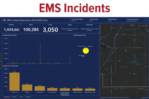
The Indiana Community Risk Reduction Coalition maintains two interactive dashboards designed for public safety agencies and the public to access fire and EMS incident data statewide. These incidents are shown on a map, and statistical figures are available at the state, district, county and local agency levels.
Data for the dashboards is from Indiana fire departments and EMS agencies as reported to the State Fire Marshal through ImageTrend. Learn more about ImageTrend Reporting
Access the dashboards below.

Open Dashboard
Open Dashboard