"Early Paths of Settlement" is one of a series of vignettes that recounts the history of the land now bisected by I-69 between I-64 and Bloomington, Indiana. Choose one or all of the vignettes to learn about the cultural and natural landscape along I-69.
Morris Birkbeck provides a first-person account of the early Indiana landscape and a companion map provides locational information. The following narrative discloses the names of towns and interchanges where historic activities have occurred along the I-69 route.
Observe the following landmarks: The Buffalo Trace spanning from present-day Clarksville northwest to Vincennes and the Red Banks Trail that ran north from Kentucky to present-day Evansville and then on to Princeton and Vincennes.
It is a feeling of confinement which begins to damp the spirit...To travel day after day among trees of a hundred feet high, without a glimpse of the surrounding country, is oppressive to a degree which those cannot conceive who have not experienced it; and it must depress the spirits of the solitary settler to pass years in this state. His visible horizon extends no farther than the tops of trees which bound his plantation . . . Upwards he sees the sun, and sky, and stars; but around him an eternal forest, from which he can never hope to emerge.
--Morris Birkbeck, July 25, 18181
- Read More
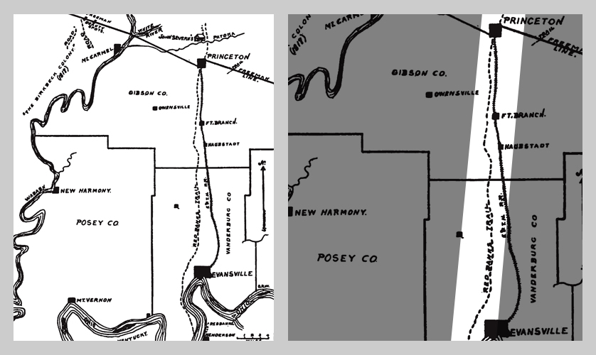
The Red Banks Trail in Vanderburgh and Gibson Counties (Wilson, Early Indiana Trails and Surveys, 1919The earliest Euro-American travelers to southwestern Indiana, often arriving from the East or South, found themselves immersed in a dense forest. Morris Birkbeck wrote that at times he felt "buried in deep forest" on his journey across Indiana. Travelers found transportation through this thickly forested setting difficult unless they followed a pathway or a waterway. Watercourses usually provided the fastest mode of transportation, but they were not always reliable and some destinations required overland travel through the dense forests.
In contrast to Birkbeck and other settlers, Native Americans were neither oppressed nor intimidated by these vast forest tracts. This was not a foreign terrain, but their homeland with which they were intimately familiar. This forested region provided all the necessities of life including shelter, clothing, and subsistence.
Long before Euro-Americans, Native Americans utilized a widespread network of familiar trails and traces that crisscrossed southwestern Indiana. One of these, the Old Salt Trace, passed north-south through Gibson County east of the Wabash River not far from a Piankashaw Village and an unidentified Indian Village near the Patoka River.
Another route known as the Yellow Banks Trace entered Pike County near the site of a Delaware Village not far from the south fork of the Patoka River.[1]
Another, and one of the best-known, routes is the Buffalo Trace, one of the widest and most-traveled trails across the state. The Miami called this route “alenaswihkanawe.”[2] It bisected the southwestern region of Indiana beginning at Clarksville along the Ohio River and angled northwest to the territorial capital of Vincennes. The entire route extended hundreds of miles from the salt licks of Kentucky into the Hoosier state and beyond. Migrating buffalo created the wide and smooth roadway; settlers quickly took to calling the route “Buffalo Trace.”[3] The width of the trace could accommodate two wagons and “was the one big overland highway in southern Indiana.”[4]
Still another, the Red Banks Trail, which ran from Henderson, Kentucky, through Evansville to Vincennes, drew its name from the Kentucky community of Red Banks (later renamed Henderson).[5] The trail passed through Princeton in Gibson County and crossed the river at Patoka, near the cabin of Gibson County’s first Euro-American settler before ending in Vincennes.[6]
As the United States took political control of southern Indiana lands after the Treaty of Grouseland in 1805, the federal government recognized the importance of navigable, overland routes to move people and goods into and out of the frontier. That same year, Congress appropriated funds for the opening of roads “through territory lately ceded by the Indians to the United States from the river Mississippi to the Ohio, and to the former Indian boundary line which was established by the treaty of Greenville….”[7]
The availability of land for sale—as well as pathways to get there—drew increased Euro-American settlers who would alter this landscape. Over the span of just a few generations, the southwestern Indiana landscape would be forever transformed, as felled trees gave way to turnpikes, roadways, open prairie, and towns.
[1] E.Y. Guernsey, “Indiana, the influence of the Indian upon its history: with Indian and French names for natural and cultural locations,” Indiana Department of Conservation no. 122, 1932.
[2] Ashley Slavey, Megan Simms, Wes Cunningham, Eric Brumfield, and Katy Morrison, “Buffalo Trace,” Discover Indiana, accessed January 11, 2017, https://publichistory.iupui.edu/items/show/140.
[3] John D. Barnhart and Dorothy Lois Riker, Indiana to 1816, the Colonial Period, vol.1, The History of Indiana (Indianapolis: Indiana Historical Bureau, 1971), 362–63; George R. Wilson, Early Trails and Surveys (Indianapolis: Indiana Historical Society, 1919), 1, 22.
[4] Wilson, Early Trails and Surveys, 16-17.
[5] Wilson, Early Trails and Surveys, 12, 47.
[6] Wilson, Early Trails and Surveys, 47-48.
[7] Andrew R. L. Cayton, Frontier Indiana (Bloomington & Indianapolis: Indiana University Press, 1996), 210-211; Gayle Thornbrough, ed., The Correspondence of John Badollet and Albert Gallatin: 1804-1836. vol. 22 (Indianapolis: Indiana Historical Society, 1963), 74.
Early Transportation And Settlement Routes
