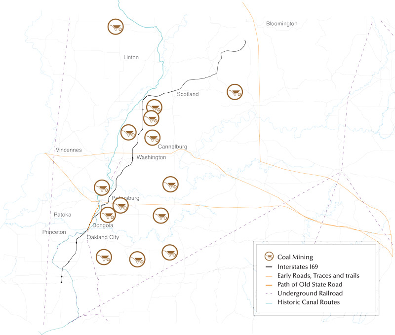
Traveling I-69 in southwestern Indiana, you pass through areas marked by immature trees or a total lack of vegetation, with man-made ponds and slag hills but few buildings. These austere segments of land demonstrate strip coal mining. "Coal Mining" is one of a series of vignettes that recounts the story of the land along I-69 between I-64 and Bloomington, Indiana. Choose one or all of the vignettes to learn about the cultural and natural landscape as you Travel I-69.
Observe the following landmarks: Cannelburg, Black Creek Coal Mine Number 1, Jackson Hill, and Shakamak State Park. A map provides locational information and the following account of a southwestern Indiana coal mine disaster provides insight into the world of shaft coal mining before strip mining became prevalent.
A newspaperman in Linton, Indiana, wrote:
" Linton, Indiana January 29, 19311. Rescue workers toiling to remove the remaining bodies from the Little Betty Coal mine following last night’s explosion today placed the number of victims at 33. Eight bodies had been removed to the surface early today. All were identified. Rescue crews reached the death pit shortly after midnight and there found 25 bodies, all of which were identified. Heavy gases prevented the immediate removal of the victims’ bodies. Two men … were taken from the mine alive. Hospital authorities said they probably would recover from the effects of the black damp"
- Read More
Undated image showing the Posey Mine entrance (Provided by Sandy McBeth, Posey County Historian)The state geologist, in 1881, observed the "promise for the future from these treasure houses is grand;" the "treasure houses" were Indiana’s coal mines. Indeed, the Indiana coalfield stretched across much of southwestern Indiana.[1]
And as early as the 1870s, miners brought out one million tons of coal per year in Indiana. Factories, homes, and even train locomotives burned coal. Southwestern Indiana possessed both the cannel and block coal. Block coal was a "hard, non-caking bituminous type" that miners harvested in large blocks. Greene County was among the state’s top producers of block coal and had over 200 coal mines by 1900.[2]
Cannel, a coal that produces a steady bright flame, was found near Cannelburg, in Daviess County in Southwestern Indiana. Contemporary writers praised the attributes of cannel coal and
described it as producing "a delightful fire on open grates." It was "well adapted to the manufacture of illuminating gas."[3]
Coal was, and still is, found in Pike, Owen, Greene, and Daviess counties. Coal created wealth; land that once sold for $20 per acre in the coal-producing areas of southwestern Indiana commanded the unheard of price of $200 per acre by 1919. As one deposit was mined out, producers moved on to already acquired land in other counties of Indiana.
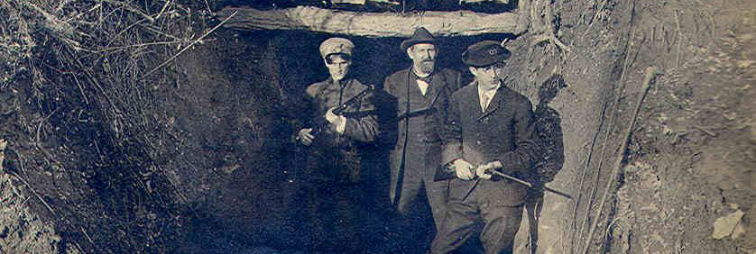
Coal might be found near the surface of the ground but sometimes seams ran as many as three hundred feet below the surface. In that instance, shafts were sunk into the ground where miners worked the seam with pick and shovel.[4]
Safety became a concern with men working so far below the surface. The Indiana General Assembly enacted legislation calling for a mine inspector to visit the state’s mines twice a year. Even with safety regulations, mining was still dangerous work. The Jackson Hill mine, which opened in 1881 in Sullivan County suffered a calamity in 1913 when a dust explosion killed four and injured 27 workers.[5]
Coal mining was an important part of southwestern Indiana’s industry and even gained international attention when a large block of coal from the Smith Mine in Pike County was featured in the Indiana Building of the 1904 World’s Fair in St. Louis. According to the Pike County Democrat, the eight-foot thick slab of coal "weighed 2,080 pounds and contained 100 bushels of superior quality coal." As the twentieth century progressed, Indiana remained the sixth largest producer of coal, but its sales shrank as a result of competition from mines in West Virginia and Kentucky.[6] After World War I, there was a greater supply of coal than demand, which led to the closure of mines and the displacement of miners.[7]
Even with fewer mines in operation, concerns over safety persisted, especially in the wake of mine disasters such as the one at Little Betty Mine in Linton, Indiana, in 1931.[8]
When mining resumed in the post-World War I world, it focused on strip rather than shaft mining. Strip mining scraped off the top surface of the landscape and resulted in the removal of
farm buildings and associated structures from agricultural land; it also robbed the soil of productivity.[9]
To counter these effects, the Indiana Coal Producers first began voluntary tree plantings on these desolate lands; later, state law mandated the replanting of grass and trees.[10] One such reclamation area was turned into Shakamak State Park; it was established in 1930 (around the time of the Little Betty disaster) on land that had been strip mined in Greene, Sullivan, and Clay counties.[11]
Land along I-69 continues to be strip mined, even today. See those areas to the west of I-69 from Mile Marker 42 to 45 and from Mile Marker 63 to Mile Marker 68. Even the pond on the McCall Family Farm (Mile Marker 71) was formed from the strip mining of agricultural fields. Scattered between fields and farmsteads, the slag hills and second-growth forests of southwestern Indiana’s strip mines show how people of the recent past have extracted value not just from the region’s rich soil but also from the coal below.
[1] Emma Lou Thornbrough, Indiana in the Civil War Era: 1850-1880, Vol. 3, History of Indiana (Indianapolis: Indiana Historical Bureau & Indiana Historical Society, 1965), 408-409; Clifton J. Phillips, Indiana in Transition: The Emergence of an Industrial Commonwealth, Vol. 4, History of Indiana (Indianapolis: Indiana Historical Society, 1968), 186.
[2] Phillips, Indiana in Transition, 186; Yael Ksander, “The Golden Age of Coal in Greene County,” Moment of Indiana History website, WIFU Public Radio in association with the Indiana Magazine of History, accessed August 23, 2019. https://indianapublicmedia.org/momentofindianahistory/golden-age-coal-greene-county/.
[3] Elia W. Peattie, “Coal,” History of the United States and the State of Indiana in The Pictorial Story of America: Containing the Romantic Incidents of History, from the Discovery of America to the Present Time (Chicago: National Publishing Company, 1896), 187.
[4] Phillips, Indiana in Transition, 187.
[5] Phillips, Indiana in Transition, 187; Annual Report of the State Bureau of Inspection Relating to Manufacturing and Mercantile Establishments, Laundries, Bakeries, Quarries, Printing Offices, Hotels, Public Buildings, Mines and Mining, Boilers, Labor Commission and License Issued (Indianapolis: Indiana State Bureau of Inspection, January 1, 1914), 372-372, accessed August 23, 2019, https://play.google.com/store/books/details?id=eCAqAQAAMAAJ.
[6] “Coal Production in the United States,” Table in The World Almanac and Encyclopedia 1900 (New York: Press Publications Co., 1900), 201, accessed September 19, 2019, https://archive.org/details/worldalmanacency1900newy/page/1.
[7] Personal correspondence from Sandy McBeth, Pike County Historical Society (dated August 16, 2014) citing article from the Pike County Democrat (May 20, 1904).
[8] Phillips, Indiana in Transition, 189.
[9] Phillips, Indiana in Transition, 188.
[10] “History of Mining in Indiana,” State of Indiana Division of Reclamation website, accessed September 9, 2019, https://www.in.gov/dnr/reclamation/files/re-IE_Citizens_Guide-IntroductionAndHistory.pdf.
[11] Glory June Grieff, “Shakamak State Park Historic District,” National Register of Historic Places nomination form (Washington D.C.: National Park Service, 2000 ), 8-5, 8-6, accessed September 9, 2019, https://npgallery.nps.gov/GetAsset/b71ca477-4d69-4a8b-8b63-98557a4b1aad.
Historic Locations Of Coal Mining Activity