Summary
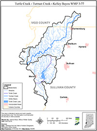
The Turtle Creek, Turman Creek, and Kelley Bayou Watersheds (TTKW) cover 115,670 acres in Sullivan and Vigo Counties in southwest Indiana. The TTKW is made up of three watersheds that each has a 10-digit Hydrologic Unit Code (HUC) area. Within the 10-digit HUCs are seven smaller, 12-digit HUC subwatersheds.
The main purpose of this plan is to outline goals and objectives designed to reduce runoff pollution from reaching the Wabash River and its tributaries. Runoff is generated when stormwater flows off farm fields, feedlots and roads. Oils, bacteria, fertilizers, sediment, and other pollutants sitting on these surfaces get washed off by stormwater and enter the streams. These pollutants are deposited by normal everyday activities like lawn and garden maintenance, livestock production, agricultural practices, and construction. The stormwater carrying these pollutants can alter the temperature of the stream, damage aquatic habitat, and add sediment to the stream flow by scouring the channel and banks.
This Watershed Management Plan (WMP) was written to meet the requirements of the 2009 WMP checklist as defined by the Indiana Department of Environmental Management’s (IDEM) Section 319 Grant Program. Meeting IDEM standards allows stakeholders to apply for State grant money to improve the watershed. The creation of this plan is not government mandated and participation is voluntary. The West Central Indiana Watershed Alliance wrote this plan to continue where The Partnership for Turtle Creek left off in 1998.