Summary
The Wabash River Defenders’ goal was to complete water quality planning for all waterbodies that drain to the Wabash River within Wabash County. The Wabash River Defenders selected the Treaty Creek-Wabash River Watershed (Hydrologic Unit Code 0512010114) as it contained most of the tributaries that drain to the Wabash River within Wabash County that have not already been included in a watershed planning process. The Wabash River Defenders identified several preliminary partners as well as concerns associated with the various practices and uses in the watershed. Specifically, the watershed includes the entire City of Wabash MS4 boundary, which requires the input and participation of the City of Wabash. The watershed is predominantly agricultural with 73% of the watershed covered by row crop agriculture or pasture land, 14% in forest or wetland and 9% in developed land uses including the City of Wabash and Town of Lagro. The engagement of the Miami and Wabash Soil and Water Conservation Districts (SWCD), Natural Resources Conservation District (NRCS), and Purdue Extension staff as well as producers across the watershed would be paramount. A majority of the land within the watershed is privately-owned and in a soybean-corn rotation. More than 30 active confined feeding operations are located within the Treaty Creek-Wabash River watershed. These operations house more than 10,000 head of cattle and more than 50,000 head of hogs. Between these animals and those housed on small, unregulated farms, more than 100 tons of manure are produced daily within the Treaty Creek-Wabash River watershed. Water chemistry data was reviewed and identified high nutrient, sediment and E. coli concentrations and limited biotic communities.
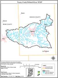
The Treaty Creek-Wabash River Watershed is part of the Middle Wabash-Little Vermilion watershed and covers portions of Miami and Wabash counties. The watershed includes a number of tributaries to the Wabash River from immediately upstream of Lagro, Indiana to immediately upstream of Peru, Indiana. The Wabash River starts in Ohio and drains about 1,600 square miles by the time it gains water from the Treaty Creek-Wabash River Watershed project area.
Seven 12-digit Hydrologic Unit Codes are contained within the Treaty Creek-Wabash River Watershed. The subwatersheds range in size from about 10,000 acres or 16 square miles to nearly 19,000 acres or 29 square miles.