Summary
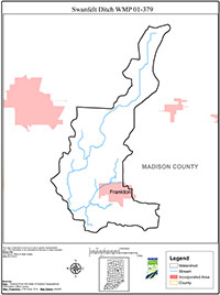
The Swanfelt Watershed is a 14 digit HUC (05120201050080) watershed that exists in northwestern Madison County. The watershed is approximately 11,264 acres in size. The watershed encompasses a large western portion of the town of Frankton. The watershed contains mixed topography and land use. Land uses include urban, suburban, and rural housing, light manufacturing, general municipal services, large and small agricultural operations.
The watershed also contains natural and constructed waterways. Pipe creek is the largest flowing body of water. The watershed is named for a small open ditch that extends from the northernmost point of the watershed to the point of the watershed where Pipe Creek and Swanfelt Ditch converge. Many small unnamed tributaries exist within the watershed. The population of the Swanfelt watershed is approximately 2,521.
The northern portion of the watershed is basically flat, farm ground. Very little topographical relief exists north of County Road 900 North in the watershed. However, south of 900 north, the watershed contains gently rolling to rolling topography. Throughout the watershed, there are natural areas, residential development, and small farmsteads.