Planning Proposals
All new Planning Proposals requesting funding for Watershed Management Plan (WMP) development must be for 8-, 10-, or 12-digit Hydrologic Unit Code (HUC) areas - the units that represent sub-basin, watershed, and sub-watershed areas, respectively.
Implementation Proposals
IDEM will continue to fund Implementation Proposals for 11- and 14-digit HUCs with approved (2004) WMPs. However, pre-2004 approved WMPs will not receive implementation funding until the plan has been updated according to the current checklist and the project area expanded to include each 10- or 12-digit HUC in which the original WMP areas are nested. Additional planning efforts (at the 8-, 10-, or 12-digit HUC scale) can be done at the same time that the old plan is being updated. With the added responsibility of updating the approved pre-2004 plan, any Implementation funding will have to be requested through a separate proposal.
Implementation Proposals (based on 2004 WMP approval) that request funding to implement at the 14- or 11-digit HUC scale and develop a new WMP (scale and geography does not matter) must adhere to the follow policy statements:
- Implementation at the 14- or 11-digit HUC scale is eligible for funding while additional planning occurs.
- The new WMP must be at the 8-, 10-, or 12-digit HUC scale.
- If the new project area overlaps with the existing 14- or 11-digit HUC-based project area, the existing area and the 10- or 12-digit HUC(s) in which it is nested must be incorporated into the new WMP. While this incorporation occurs, implementation within the 14- or 11-digit HUC project area is still eligible for funding.
- If the new project area does not overlap with the existing 14- or 11-digit HUC project area, the new WMP does not have to incorporate those areas. The 14- or 11-digit HUC project area can continue to receive implementation funding as related in 2a, above.
This guidance has been developed to provide a better understanding of the watershed levels and delineations. Any additional questions pertaining to the statements above may be discussed with a Nonpoint Source staff member or Watershed Specialist. For further explanation of the changes in hydrologic unit areas, the following details are provided to better understand the changes to the delineations and numbering system. Additional details on the criteria and decisions made by the USGS and USDA/NRCS can also be found at the following links:
- Federal Standards for Delineation of Hydrologic Unit Boundaries (Version 2.0) [PDF]
- Watershed Boundary Dataset
Instructions for Converting HUCs from 11s/14s to 10s/12s:
With the U.S. Geologic Survey’s national development of the watershed and sub-watershed areas (10- and 12-digit HUCs), the previously developed watershed sub-watershed delineations (11- and 14-digit HUCs) in the State of Indiana was affected. These previous delineations had been done for Indiana by the Indianapolis Office of the USGS in the mid-1990’s and were based upon Indiana-specific characteristics of hydrography. When the new nationally derived HUC areas were completed for Indiana and neighboring states, this provided consistency across state lines and within Indiana when compared with other states. However, the national criteria were not necessarily consistent with the criteria establish in the initial Indiana project.
As a result of the adoption of the national layer, there are changes when comparing the delineations of the watershed and sub-watersheds between the earlier version and the national layer. Also, this resulted in changes in the numbering beyond the deletion of the extra “placeholder” zeros. To better explain the differences, the following notes and illustrations are provided.
Definitions:
- Sub-Basins – HUC 8s have stayed the same in both HUC layers.
- Watersheds – HUC 10s in the new layer and HUC 11s in the Indiana layer.
- Sub-Watersheds – HUC 12s in the new layer and HUC 14s in the Indiana layer.
Note: The Sub-Basins and Watersheds layers were derived from their Sub-Watershed layers by extrapolating the associated area records and merging them together.
Typically, in the development of the new delineation, the HUC 14 sub-watersheds had been consolidated or redefined to rebuild the new HUC 12 sub-watersheds. Below there are 2 comparative illustrations of the watersheds within a sub-basin and the sub-watersheds within a watershed. The area of the state that was selected for these examples is in the Flatrock River area in east-central Indiana and presented the most variability in the delineations and numbering between the 2 layers.
In the map on the right, the sub-basin Flatrock-Haw is shown with the watersheds delineated in blue outlines for the HUC 10 boundaries and in white outlines with color shades for the HUC 11 boundaries/areas. The watershed shown in the map on the left is a close-up of the HUC 11 watershed (in cyan) on the map on the right. Comparing the changes in the Conns Creek watershed there is a distinct realignment of the watersheds that affected the sub-watersheds, namely the lower right crook of the HUC 11 that contained three HUC 14s. Due to the realignment, these three HUC 14s have been reassigned to a different HUC 10 watershed.
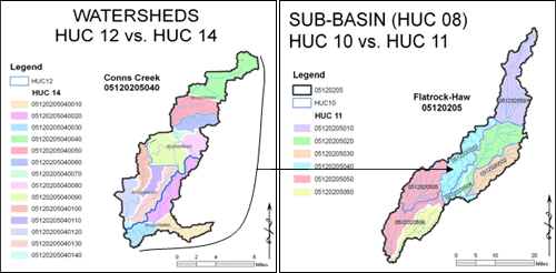
Examples of the changes between the old and new watershed and sub-watershed delineations
This also affected the numbering of the HUC 10s and HUC 12s since the number of sub-watersheds changed. In this example, the Conns Creek watershed had been designated as 05120205040, but it changed to 0512020503 moving the 3 old HUC 14s into the new Mill Creek-Flatrock River watershed 0512020504. Other numbering changes may have been a result of reassessing the numbering based on stream order (from headwaters to confluence) as appears to be the case with this sub-basin.
While the majority of watersheds throughout Indiana have not been physically changed, there may be changes to the number of the HUC. It is important to check this information when updating a WMP or developing a new one in an area seemingly unaffected by the new delineations. As a result of the extensive changes to the sub-watershed areas, always check on the HUC of the sub-watersheds when updating WMPs or submitting applications for Section 319 planning or implementation funds.