Indiana was admitted to the Union as the nineteenth state on December 11, 1816. Leading up to that event were many years of preparation as the United States tried to define itself as a nation after the American Revolution.
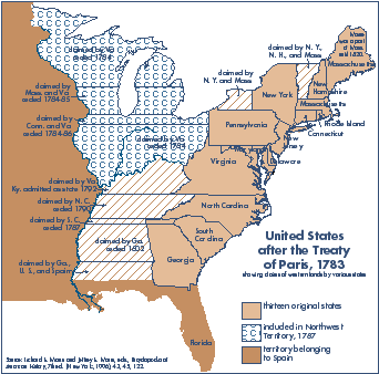
When the U.S. won the American Revolution, it also won hundreds of thousands of square miles of land east of the Mississippi River. The Treaty of Paris in 1783 with Great Britain defined the borders of the U.S. (Patrick, 8).
An important first step was to survey the land so that it could be sold to settlers. On pages 3-4, there is an introduction to how Congress accomplished that need.
The Ordinance of 1784 and the Ordinance of 1787 were passed by Congress to provide an orderly process of government to form new states. These ordinances are discussed on page 5. Specific steps for the formation of Indiana are charted on page 6.
A brief introduction to the Northwest Territory is on page 7. An introduction to Indiana Territory is on pages 8-9.
Territorial Governor William Henry Harrison spent much time making treaties with Indian tribes to buy their lands. Relations with Indian tribes are briefly discussed on page 10.
A major issue was financing government. A summary is presented on page 11.
On pages 12-13, the question of slavery in the territory is introduced.
On page 14, a journal excerpt and other material provide some insight into life during this period.
The bibliography and additional resources are provided on page 15.
The timeline throughout provides many details for a broader historical context. William Henry Harrison's life and career are highlighted in the timeline.
A plat map of Vincennes in 1792 is reproduced on the back cover. Part of the official record of the beginnings of Indiana Territory is reproduced on the front cover.