 WLEB Story Map: Indiana's Commitment to Enhance Water Quality in the Western Lake Erie Basin
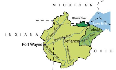
The Western Lake Erie Basin (WLEB) is one of our nation’s most significant collections of inland rivers and streams. The WLEB covers nearly 7 million acres and it encompasses most of northwest Ohio, as well as portions of northeast Indiana, and southeast Michigan. Specific to Indiana, it covers parts of Steuben, DeKalb, Allen, Noble, Adams and Wells Counties. Around 75 percent of the land is in agricultural production. Approximately 1.2 million people live in the Basin, distributed between three urban centers, Toledo, Ohio; Fort Wayne, IN; Lima, Ohio and numerous cities and towns.
During the 1970s and 1980s, water quality in the Basin was impaired by algal blooms. At that time, particulate phosphorus that attached to soil particles was considered the culprit for the impaired conditions. With assistance from the Natural Resource Conservation Service, State Departments of Agriculture and Soil and Water Conservation Districts, as well as many other agencies, farmers began to implement no-till and conservation tillage into their farms and the phosphorus loads were greatly reduced.
Unfortunately, since the mid-1990s algal blooms have been on the rise. According to recent studies, it appears that Dissolved Reactive Phosphorus (DRP) (soluble phosphorus) is considered to be the main problem. This form is a ready food source for algae and plays a factor to the rapid growth resulting in algae blooms. However, new data suggests fertilizer phosphorus left on the surface, when followed by heavy rainfall, can be a major source of phosphorus loading in surface water. (Our Water, Our Future, 2013) The increased levels of nutrients flowing into Lake Erie during precipitation events have resulted in massive Harmful Algal Blooms (HABs) throughout the summer and fall months of 2010 and 2011.
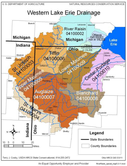
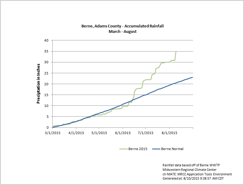
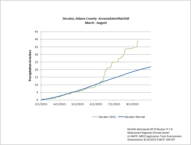
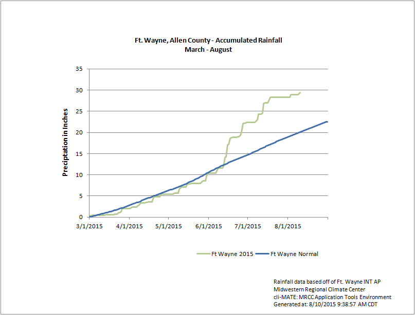
Indiana is working with landowners in our communities to help improve the water quality of our streams and inland rivers, and ultimately Lake Erie. The Indiana State Department of Agriculture is partnering on several projects which will result in a significant measurable load reduction in total phosphorus in the St. Joseph, St. Marys, Upper Maumee and the Auglaize watersheds through the leadership of training, education, promotion, development and installation of voluntary water quality programs and best management practice installation, nutrient management plan development, soil testing and training, water quality grant development & implementation, guidance & assistance for best management practice implementation through federal, state & local agencies and non-governmental organizations, coordination of the 4Rs of Nutrient Stewardship Program with agricultural industry, landowners & producers, implementation of Great Lake Restoration Initiatives & Clean Water Indiana projects. In 2015, Indiana received record rainfall within the Western Lake Erie Basin.
- Indiana WLEB Initiatives
- Western Lake Erie Basin Partnership
- Indiana's Great Lakes Water Quality Agreement (GLWQA) Domestic Action Plan (DAP) for the Western Lake Erie Basin (WLEB)
- Western Lake Erie Basin Sediment and Nutrient Load Reductions 2017
- Indiana Department of Environmental Management - Maumee River Watershed Management Plan
- Indiana Department of Natural Resources - Lake and River Enhancement Program
- Indiana Soil and Water Conservation District Initiatives
- Indiana USDA Natural Resources Conservation Service - Western Lake Erie Basin Initiative
- Indiana USDA Natural Resources Conservation Service - Great Lakes Restoration Initiative
- The Nature Conservancy Initiatives
- National WLEB Initiatives
- United States Natural Resources Agricultural Research Service - Conservation Practice Adoption on Cultivated Cropland Acres: Effects on Instream Nutrient and Sediment Dynamics and Delivery in Western Lake Erie Basin, 2003-06 and 2012
- United States Environmental Protection Agency - Great Lakes Water Quality Agreement Recommended Binational Phosphorus Targets
- United States Environmental Protection Agency - Lake Erie
- USDA Natural Resources Conservation Service - Western Lake Erie Basin Project
- Resources
- WLEB Action Plan
- 4Rs of Nutrient Stewardship
- Map of Western Lake Erie Basin
- Michigan Farmer-Led Watershed Conservation
- Map of Western Lake Erie Basin Accumulated Precipitation - March 1 thru August 10, 2015
- Map of Western Lake Erie Basin Average 30-Year Rainfall - March 1 thru August 10
- Graph of Berne, Indiana Accumulated Rainfall - March 1 thru August 1, 2015
- Graph of Decatur, Indiana Accumulated Rainfall - March 1 thru August 1, 2015
- Graph of Fort Wayne, Indiana Accumulated Rainfall - March 1 thru August 1, 2015
- Soil and Manure Sampling Program Brochure
- Recommended Binational Phosphorus Targets
- ISDA WLEB Contacts
Julie Harrold
Program Manager - Water Quality Initiatives
260.341.6698
jharrold@isda.in.govJennifer Thum
District Support Specialist
260.341.6966
jthum@isda.in.gov - Related Links