Summary
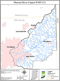
The Maumee River Watershed is no exception to the water quality problems affecting most rivers and streams today. The Maumee River, which begins at the confluence of the St. Joseph and St. Marys Rivers in Fort Wayne, IN, is 137 miles in length and stretches across a variety of landscapes before it outlets into Lake Erie in Toledo, OH. With over 430 miles of tributary perennial streams located within the Upper Maumee watershed alone (Hydrologic Unit 04100005), the Maumee River is the largest contributor to Lake Erie, and is a major source of sediment and nutrients entering the lake which has contributed to the growing blue-green algal blooms and hypoxic zone in the Western Lake Erie Basin.
The local Soil and Water Conservation Districts (SWCD) located within the Upper Maumee River watershed recognized the growing concern of high nutrient levels entering Lake Erie through the Maumee River causing massive algal blooms. Therefore, the Allen County, Indiana SWCD and Defiance County, Ohio SWCD applied for, and were awarded, grants from the Indiana Department of Environmental Management (IDEM) and the Ohio Department of Natural Resources (ODNR), respectively, to help mediate the problem of pollutants entering the Maumee River, and thus, Lake Erie.
The purpose of this document, a comprehensive watershed management plan (WMP), is to identify areas of concern in the watershed and develop an action register, guided by local stakeholders, to reduce the amount of pollution entering the river system, and improve overall water quality and the quality of life for those that live around and rely on the river. This WMP meets requirements set by the Indiana and Ohio regulating agency; the IDEM, ODNR and Ohio Environmental Protection Agency (OEPA).