Following years of preparation by surveyors, engineers, and commissioners, actual construction of a canal could begin. The start of construction was a time of great celebration for communities. It was also the beginning of a long and expensive process.
Regardless of what type of specific construction was needed, there were four basic steps in building a canal: digging the canal, providing means for the canal to cross rivers and streams, overcoming changes of altitude in the route of the canal, and getting water into--and keeping it in--the canal.
The next two pages provide a brief description of the processes and structures in canal building. Words in boldface type are defined in the Definitions columns using an 1840 source; look up words in a modern dictionary to see if changes in meaning have occurred.
Sources: Way, 134-41; definitions are from Tanner, 235-64.
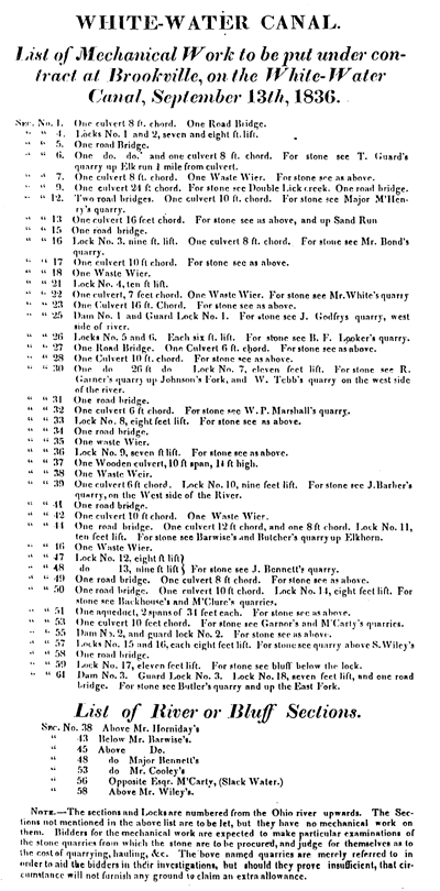
This broadside demonstrates the complexity of canal construction. Contractors bid on sections of approximately one-half mile. Engineers had prepared specifications for contractors (as illustrated elsewhere in this issue) for each part of the canal to be bid.
Image: Indiana State Library, Indiana Division.
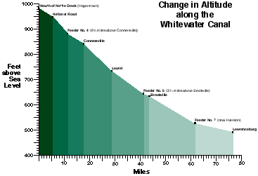
The Whitewater Canal was an extraordinary engineering feat. This chart shows the change in altitude from Hagerstown to Lawrenceburg. Over the seventy-six miles of the canal, the descent was 491 feet, requiring fifty-six locks.
By comparison, the Wabash and Erie Canal at 468 miles was the longest U.S. canal. From its Fort Wayne summit to Evansville, it descended 450 feet; from Fort Wayne to Junction, Ohio, it descended 55 feet. Only seventy-three locks served the entire canal. Shaw, Canals, 143; Castaldi, 11; Annual Reports of the Geological Survey of Indiana, 1876-1878 (Indianapolis, 1879), 240-41, 252.
1) Digging the canal
Draining and grubbing the land along a canal line usually preceded excavation. Laborers used shovels and carts to move the earth. Machines such as scrapers, dredges, and cranes were also used.
The amount of excavation to build the correct embankment was figured and charted by the engineers. On level ground 2.75 feet of excavation was needed to raise the banks enough to permit the required water depth of four feet (Tanner, 240-41).
If the bottom of the canal was sandy and did not hold water, puddle was added to the sides and bottom of the canal. Men and oxen were used to press the puddle into place.
The drawing below by Myron S. Webb shows some dimensions of the Whitewater Canal: twenty-six feet wide at the bottom; forty feet wide at the water line; ten-feet-wide towpath; six-feet-wide berm bank. The water was four feet deep.
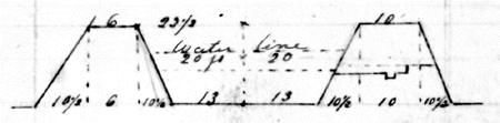
Image: State Archives, Indiana Archives and Records Administration.
2) Crossing rivers and streams
Along the course of a canal, culverts and aqueducts carried canal water--and canal boats--over streams and rivers. Floods often damaged or washed away these structures.
The illustration below is adapted from an engineer's foundation plan drawing (bird's-eye view) of the Duck Creek Aqueduct at Metamora, Indiana. This drawing along with written bills of materials were exhibited for contractors by Whitewater Canal engineers at Connersville on July 24, 1838. This aqueduct exists today as a covered bridge aqueduct (Shaw, Canals, 143).
The above drawing is incomplete in this format. The complete drawing can be seen in the pdf version of the issue.
A culvert on the Whitewater Canal is shown in a 1995 photograph. Notice the arch of stone and the timber-lined bed of the stream.
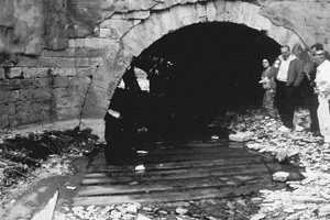
Image: Martha Wright
3) Changes in altitude of the canal
A canal can be described as a connected series of level channels. To move a canal boat from one level to another level, a connecting lift lock was necessary. The amount of lockage required for a canal because of the terrain it crossed affected its cost. Lockage--which required more time for boats--also made a canal less efficient to operate and travel.
Locks were built of timber or stone depending on the availability of materials nearby. Composite locks were also built. Cut stone locks with water-proof cement were the most durable. In 1839, the Indiana Board of Internal Improvement report (48) noted approval of a contract with a manufacturer in Louisville, Kentucky for 2,000 barrels of cement (or water-lime) at $2.621/2 each. This purchase was for locks being built on the Whitewater Canal.
The 1995 photograph shows the remains of a lock on the Whitewater Canal.
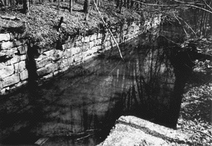
Image: Martha Wright
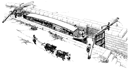
Image: Tunis, [89].
4) Getting and holding water in the canal
One of the major tasks of surveyors locating a canal route was to determine if sufficient water was available in nearby rivers to keep canal boats floating, even in the driest weather. Sometimes, reservoirs had to be built. Dams were built to control water levels and to provide pools for slackwater navigation. Feeders were dug to get water to the canal.
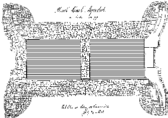
The drawing below is a portion of Myron S. Webb's diagram for a dam. The drawing depicts a crib of timber filled with stone and covered with planking, resting on a foundation of brush and unhewn trees.
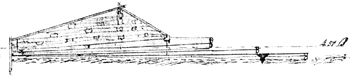
Image: State Archives, Indiana Archives and Records Administration.
The foundation (or base) specifications in an 1836 ledger book for a dam on the Whitewater River at Brookville call for 1,160 unhewn trees from eight to ten inches wide and forty-five to sixty feet long with as much brush attached as possible.
The 1995 photograph shows the feeder dam on the Whitewater River near Laurel, Franklin County.
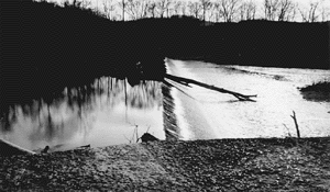
Image: Martha Wright