INDOT has helped the state reach new heights in the GPS world.
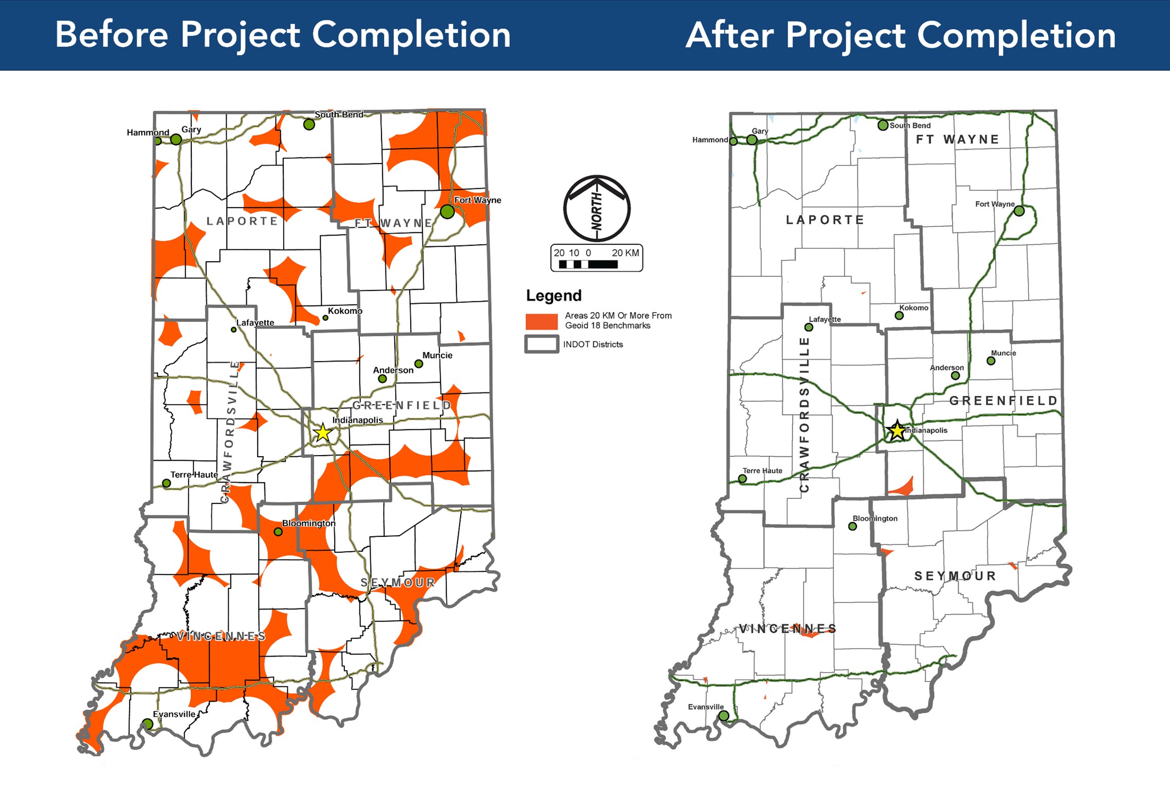
The Indiana Height Modernization Project, which started in 2013 and ended in 2023, was performed to improve statewide access to accurate, reliable, and consistent heights or vertical measurements across the state available via GPS surveying. The project provided information for the National Geodetic Survey (NGS) to update and refine the elevation information used by surveyors, engineers, emergency managers, scientists, farmers, and natural resource managers. These users need accurate height measurements for mapping, flood-risk determination, transportation, land use, ecosystem management, and more.
INDOT’s Land & Aerial Survey Office, managed by Eric Banschbach, coordinated all project activities between INDOT, the Federal Highway Administration, consultants, and federal agencies. It also submitted and managed the funding.
After a pilot project was completed in Hamilton County, the Indiana Height Modernization Project expanded into a phased statewide project, starting in 2013 in the Vincennes District and ending in 2023 in the Fort Wayne District.
“During the early parts of the project, some of my office’s field crew staff — along with some INDOT district survey crew members — assisted with the field reconnaissance and observations,” said Banschbach. “During the later stages, consultant crews were used for all field observations.”
The NGS has pushed for a nationwide effort to better provide and maintain accurate heights. To do so, Indiana created an accurate connection between the original networks of monumentation established by conventional surveying techniques with the modern National Spatial Reference System (NSRS).
This was a classic example of old meets new.
The project featured “monuments,” which are physical survey markers stabilized in the ground that serve as benchmarks. These monuments feature an exact center point in which benchmark information — vertical, horizontal, and velocity — can be referenced.
Existing and new monuments were used in the modernization project.
Existing monuments: These were usually brass tablets set in concrete by the federal government during nationwide leveling projects. At one time, Indiana had nearly 12,000 of these monuments, with more than 90% of those set between 1874 and 1979. Fewer than 20% of these existing monuments remain.
New monuments: Monuments set for this project were stainless steel rods driven to bedrock or a stable point, enclosed in a 6-inch PVC pipe with an aluminum access cover. More than 100 reset monuments were installed for this project.
“Some of the new monument rods didn’t hit bedrock until more than 100 feet into the ground,” said Banschbach. “We added more than 100 new benchmarks and scrutinized and performed static GPS observations and data processing for more than 500 passive monuments. This involved three separate five-hour observations on each.”
The ability to collect static GPS observations on existing and new monuments throughout Indiana enables the NGS to provide and maintain reliable, updated heights as part of a broader nationwide effort. Now, accurate heights or elevations can be secured when using GPS for land, structures, water, moving vehicles, ships, reference points, and much more.
The high precision leveling achieved with this project was astounding; in one example, two monuments spaced a mile apart have a 0.03mm difference in measurement from the established value. (For comparison, a penny is just over 1.5mm thick.) These GPS observations were tracked and scrutinized by NGS software.
“GPS alone does not naturally provide accurate heights, but it can when NGS is provided with the necessary data to improve modeling,” said Banschbach, who noted that most infrastructure projects depend on GPS.