GIS at IDHS: Leveraging GIS to Make a DifferenceThe Indiana Department of Homeland Security (IDHS) is comprised of employees and programs that cover many disciplines and topics. It is no surprise that Geographic Information System (GIS) efforts at IDHS span a number of topics to bring more data to the residents of Indiana. Recently, IDHS GIS staff worked with the agency’s Public Affairs Office (PAO) to craft public-facing dashboards and tools. In some cases, GIS staff were able to transform existing data collection efforts into usable geospatial information. In other cases, data sets were built from scratch. Either way, the process of transforming and creating data to meet customer needs is a fulfilling endeavor.The following examples highlight a few of the ways IDHS has leveraged GIS technology to share information with the public. Feel free to click on the links and explore!
|
Public Safety Job Openings in Indiana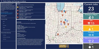
This dashboard connects the public safety community with available jobs across the state. Postings are submitted voluntarily by external agencies who seek to publicize their employment opportunities. Previously, IDHS accepted external job posting announcements and posted the listing on a PDF on the IDHS website. GIS staff upgraded the user experience from all angles! External agencies now can submit a job posting via Survey123. Submissions trigger an email notification to the IDHS PAO team, which vets the submission for completeness and validity through a secured JavaScript viewer. Once a posting is vetted, it is automatically added to the dashboard. Additionally, once a posting deadline has passed, it will automatically be removed from the map. This ensures users are seeing the most up-to-date information.
Residential Fire Fatalities in Indiana 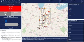
IDHS fire investigators are often called to assist local jurisdictions in residential fires where a person died or if there is a question about the cause and origin of the fire. This dashboard provides information regarding each residential fire in which a fatality was reported (whether IDHS is performing an investigation or not). This project started as a way to better understand where fire safety outreach efforts are needed. What began as an MS Excel spreadsheet is now an interactive dashboard that tracks residential fire fatalities dating back to 2019. The IDHS PAO updates data monthly through a secured JavaScript viewer.
Statewide Contact Information (IDHS)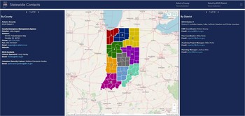
IDHS provides Indiana residents with accurate and up-to-date contact information for each county’s Emergency Management Agency, as well as Homeland Security liaisons and IDHS District personnel. This dashboard allows users to interact with the map and refine search results for their county. Information in this dashboard is updated on an as-needed basis by the IDHS PAO team through a secured JavaScript viewer. The previous process to keep this information current required IOT’s involvement, multiple steps and was time consuming. This GIS-based solution allows for immediate updates!
Tornadoes in Indiana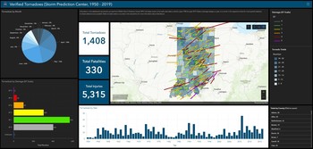
What started out as a “for fun” project turned into a useful tool. This dashboard utilizes confirmed tornado data from the NOAA Storm Prediction Center (SPC). The SPC updates data on an annual basis (although the schedule is a little behind at present). Users can interact with the dashboard in several ways to learn where tornadoes have crossed our landscape over time. The IDHS PAO team frequently shares this dashboard during Severe Weather Preparedness Week. It also serves as a good resource for planners.It's an exciting time to be in the business of GIS. As technology advances and data collection efforts gain momentum, IDHS looks forward to continuing to leverage GIS to make a positive impact. If you have questions or comments, please feel free to reach out to Ashlee Moore at asmoore@dhs.in.gov.
| 
March 2022
Megan R.L. Compton
Indiana Geographic Information Officer (GIO)
IN Office of Technology
100 North Senate Ave.
Government Center North
Indianapolis, IN 46204
International Women’s Month: Census Data
OpenTopography: Open Access and Processing of Statewide LiDAR Topography
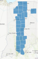
2021 Indiana Statewide Data Harvest CompletionThe Indiana Statewide Data Harvest has published the 2021 datasets, including: parcels, addresses, road centerlines and administrative boundaries. Building on the momentum of this fourteen-year program, the Indiana Geographic Information Office, in partnership with IGIC and with the support of the IUPUI Polis Center, has received and validated the four framework data layers derived from local government participation.
OrthoImagery DownloadThe 2021 spring orthoimagery of the center 1/3 of the state is now available to download.
Upcoming ConferencesWant the GIO to attend your event? Submit a GIO appearance request form and we will be in touch.
Training Opportunities· Government Rates Available
|