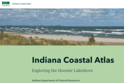
Indiana’s Lake Michigan Coastal Atlas
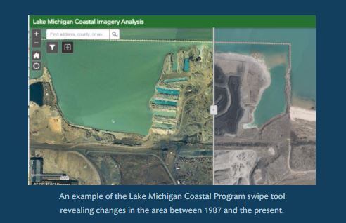
Although better known for auto racing and basketball, the State of Indiana hosts 45 miles of Lake Michigan shoreline. This region contains areas such as industrial complexes, residential communities, sensitive natural environments, to name but a few. Coordinating these varied interests is the Lake Michigan Coastal Program, managed by the Nature Preserves division of the Indiana Department of Natural Resources. This program supports the partnership between government agencies, from local to federal, as well as local entities to protect natural and cultural resources within Indiana’s Lake Michigan drainage area. Charged with developing a tool to provide such support, Special Projects Coordinator Ashley Sharkey looked to GIS as the ideal solution and is currently developing Indiana’s first Lake Michigan Coastal Atlas. With grant funding from NOAA, Ashley’s team has contracted the Sanborn Map Company, Inc. to develop a digital resource showcasing the state’s robust geospatial holdings in this area. The atlas currently under development is based on Esri’s StoryMap platform and will initially address three areas – flooding, wetland management, and imagery. This atlas will be a resource for stakeholders to make data-driven decisions in the management of this region. Rather than a product that is simply developed and delivered, Sanborn is collaborating with DNR to create an atlas that inherently maintains active links to resources. DNR will maintain the atlas in the long term as an ever-evolving resource.As a proof of concept, a StoryMap was initially developed in-house to showcase the many capabilities currently available, though not widely known. Such features include the imagery swipe tool to allow users to interactively see the changes in the Lake Michigan shoreline over the years. This is a prime example of utilizing the states archive of aerial imagery captured over the years. Imagery can also be featured in an embedded three-dimensional scene view, highlighting the region’s rolling dunes. Other tools presented in the atlas are existing resources for floodplain management, such as DNR’s new Indiana Floodplain Information Portal (INFIP.) This interactive mapping application allows the public to receive authoritative answers to questions involving flood hazards. Bob Wilkinson of DNR’s Division of Water has created this tool and serves as one of many collaborators on the atlas.
Interest and cooperation are growing rapidly outside state government as well. Dr. Troy from Purdue University has met with Ashley to discuss possibly include imagery from his holdings into this project. Potential collaborations may include Soil and Water Districts and local historical interests. Phase I of the Lake Michigan Coastal Atlas is scheduled to be complete by mid-May of this year. Plans are already underway for Phase II of the atlas to enhance its functionality. Announcements will be coming soon as the Lake Michigan Coastal Atlas nears completion.
FEBRUARY 2022
Megan R.L. Compton
Three easy ways to personalize ArcGIS Pro
Want to learn how to personalize ArcGIS Pro? Follow along to see three easy ways to personalize your ArcGIS Pro experience using built-in settings and options. This video was recorded using ArcGIS Pro 2.9 in December 2021 .
Upcoming Conferences Want the GIO to attend your event? Please submit a GIO appearance request form and we will be in touch.
Training Opportunities