IndianaMap: Guide to the Data Gallery
Introduction
IndianaMap is a centralized hub for geospatial data in Indiana, providing free and authoritative datasets for state agencies, consultants, planners, researchers, and the public. Built using ArcGIS Hub, the website integrates ArcGIS Online (AGOL) content and makes this content accessible via the IndianaMap website. In this blog, we’ll go over the Data Gallery, which is a central component of IndianaMap. We’ll discuss how users can search, filter, and download datasets. We will also cover the different dataset types found within the gallery and discuss the ISO topic categories that are used to catalog the data.
Data Gallery
The Data Gallery is IndianaMap’s central repository for open geospatial data in Indiana. The Data Gallery currently houses 463 items (with more items to be added moving forward). Whether you’re looking for environmental, infrastructure, or demographic data, the Data Gallery provides easy access to a wide range of geospatial datasets. Let’s begin by discussing how users can most efficiently search through the Data Gallery using filters.
Filtering Your Search
Users can refine their search using filters and keywords to narrow down their focus to the most relevant datasets. We will discuss how to filter the data gallery by searching for dataset type, dataset category, and dataset tags.
Dataset Types:
- Feature Services: Vector-based layers representing points, lines, or polygons. Examples include college and university locations, religious center locations, hospital locations, managed lands, streams and rivers, etc.
- Map Services: Pre-rendered maps, often used for quick visualizations, such as crop cover, sinkhole density, annual precipitation distribution, etc.
- Image Services: Raster-based data, including aerial imagery and elevation models.
- Web Maps: Interactive maps that allow users to explore various datasets and layers.
- Web Mapping Applications: Specialized apps built on geospatial data that offer additional functionalities.
Source:
Datasets on IndianaMap come from multiple contributors, ensuring the data is authoritative and comprehensive. Example sources include “IndianaMap”, “Indiana Geological and Water Survey”, “Indiana Department of Natural Resources”, and other federal and state agencies.
Tags:
Users can also search for datasets by searching for tags that are associated with the datasets. For example, searching for the tag “precipitation” brings up multiple datasets on annual precipitation.
Categories: Last, users can search for datasets by searching for categories. IndianaMap follows the ISO standards for cataloging geographic information. These categories provide a consistent framework for describing datasets, making it easier to search and understand their applications. The table below contains the ISO categories (image from ESRI) used for IndianaMap:


The video above demonstrates how users can use filters while searching the data gallery for datasets.
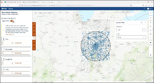
Downloadable Datasets
Once users find a dataset of interest, they have several options for downloading and customizing the data. IndianaMap allows users to filter a dataset to narrow down the results to a subset of the original statewide dataset. This can be done by defining attribute or location parameters.
Filtering and Downloading Data
Users can filter datasets by:
- Selecting attribute parameters (e.g., specific land types or date ranges).
- Drawing or importing polygons to select data within a geographical area.
- Adding a point and applying a buffer to select records within a set radius.
Once filtered, datasets can be downloaded in multiple formats:
- Shapefile (for use in GIS software)
- CSV (for tabular data)
- GeoJSON (for integration with web mapping tools)
- KML (for use in Google Earth and other platforms)
A comprehensive guide to filtering and downloading datasets can be found in the FAQs and Guides section of the IndianaMap website, or see the video below.
The video above demonstrates how users can filter an individual dataset via buffer distance, drawing a polygon, or defining attribute parameters.
Conclusion
The Data Gallery is a useful tool for accessing Indiana’s vast array of geospatial datasets. With over 463 datasets and growing, IndianaMap is an essential resource for anyone needing authoritative, accessible, and comprehensive geospatial data. By utilizing its filtering, searching, and download features, users can find and work with the data they need for their projects.
Contact Us
For additional information and resources on utilizing IndianaMap tools and data, please visit the "IndianaMap FAQs & Guides"section of the IndianaMap website. Additionally, you can reach IGIO IndianaMap staff via email at indianamapsupport@iot.in.gov or follow the "Contact Us" link on the IndianaMap website.