The Ecosystems of the Indiana Coastal Region Poster series is part of the LMCP’s outreach campaign to raise awareness of Coastal Resources. The campaign started in 2005 with the release of the Ecosystems of the Indiana Coastal Region – Overview poster. New posters are unveiled roughly every two years.
Below you can view the eight posters that have been unveiled so far. There are four more posters planned to complete the series. The LMCP commissioned local artist Barb Labus to develop the posters, which contain a wealth of information in a striking format. Funding for this initiative is from our partners at the National Oceanic and Atmospheric Administration Office for Coastal Management under the Coastal Zone Management Act and the U.S. Environmental Protection Agency via the Great Lakes Restoration Initiative (see specifics below regarding source per poster)
Posters may be picked up at locations in the coastal region.
Indiana Dunes State Park Nature Center (Hours Vary by Season):
1600 N. 25 E
Chesterton, IN 46304Indiana DNR Michigan City Office (Hours Vary)
100 West Water Street
Michigan City, IN 46360
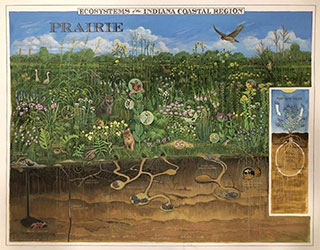
Prairie - 2021
Prairie: a natural community type that consists mostly of native grasses, forbs, and shrubs. Occasionally, prairies are referred to as “grasslands” because they have very few or no trees. Prairies can occur in a variety of soil moistures, including wet prairies with some periodic surface water to dry sand prairies on dunes. Within the Lake Michigan watershed, most prairies occur on sandy soils; however, there are a few prairies, known as “black soil” prairies, that occur on fine-textured silt loam soils with deep and dark A horizons.
This publication was made possible by grant Award #NA18NOS4190010 from the National Oceanic and Atmospheric Administration Office for Coastal Management.

Marsh - 2018
Marsh: a wetland community that consists mostly of herbaceous vegetation such as grasses, sedges, rushes, ferns, and aquatic plants. Most marshes have water in them at all times and the water levels fluctuate. Occasionally, the water level can diminish for short durations to expose the soil. Many marshes occur within low basins or water-filled depressions and along the edges of rivers and streams.
This publication was made possible by grant Award #NA17NOS4190031 from the National Oceanic and Atmospheric Administration Office for Coastal Management.
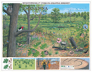
Savanna - 2016
Savanna: Communities with a grassy or herbaceous ground cover and a tree canopy cover of less than 80% by more than 10%. The dominant trees are characteristically black oak and white oak on sandy soils, and burr oak and other oaks on silt loam soils.
This publication was made possible by grant Award # NA15NOS4190086 from the National Oceanic and Atmospheric Administration Office for Coastal Management.
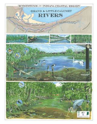
Rivers – 2014
River: A stream with a watershed of 200 square miles or more. A river is fed along its course by converging tributaries and can be further classified by size and gradient.
This publication was made possible by a Great Lakes Restoration Initiative Grant from the US EPA.
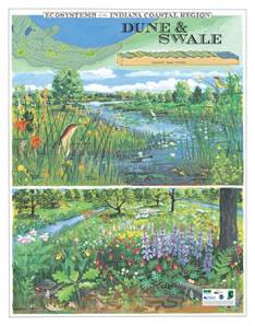
Dunes & Swale – 2012
Dune and Swale: A series of low, linear east-west sand ridges interspersed with linear east-west wetlands. They run parallel to the present-day Lake Michigan shoreline, primarily in Gary and Hammond. They feature a variety of plant communities, primarily prairie, and savanna on the ridges, marsh, and/or ponds in the swales.
This publication was made possible by grant Award # NA10NOS4190187 from the National Oceanic and Atmospheric Administration Office for Coastal Management.
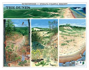
The Dunes – 2010
Dune: Hills, mounds, or ridges of wind-deposited sand most prominently located near Lake Michigan. A variety of plant communities are found in Indiana’s dune complex, which includes a beach, foredune, and interdunal pond and dune, and a variety of plant communities ranging from prairie and savanna to forest.
This publication was made possible by grant Award # NA09NOS4190079 from the National Oceanic and Atmospheric Administration Office for Coastal Management.
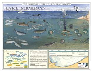
Lake Michigan - 2007
Lake Michigan is the second largest of the five Great Lakes. Indiana’s shoreline lies along the more temperate southern basin of the lake. This major freshwater ecosystem provides water for consumption, transportation, power, and recreation as well as critical fish and wildlife habitat.
This publication was made possible by grant Award #NA06NOS4190161 from the National Oceanic and Atmospheric Administration Office for Coastal Management.
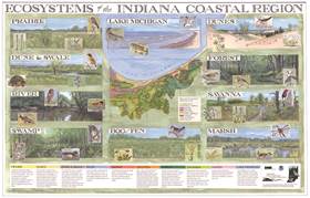
Original/Overview Poster – 2005
This poster provides an overview of the 10 ecosystem types to be depicted in the series. It provides a definition of each ecosystem type that is carried through each subsequent poster. This publication was made possible by grant Award #NA17OZ2334 from the National Oceanic and Atmospheric Administration Office for Coastal Management.