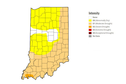
U.S. Drought Monitor
Under dry conditions, summer activities such as grilling and setting off fireworks have the potential to cause large fires. According to the National Fire Protection Association, grills and fireworks cause thousands of fires every year. Always use caution when handling anything that produces heat or could produce a spark, but take extra precautions during especially dry weather.
U.S. Drought Monitor
Dry Weather Safety Tips
Quick Tips
- During dry weather, keep a fire extinguisher nearby outdoor cooking fires, such as when grilling.
- When finished with charcoal grilling, let the coals completely cool and dispose of them in a metal container.
- If a burn ban is in effect for the area, call the local fire department to inquire about what activities are included in the restriction.
- Never throw a lit cigarette out the window of a vehicle. It could land on dry grass or be blown into dry vegetation and start a fire.
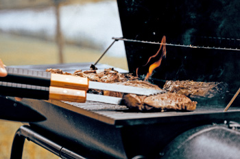
Outdoor Cooking
Grill fires cause an average of 9,000 home fires per year. Before firing up the barbecue, review some tips to help prevent a delicious meal from being served with a side of hospital gelatin.
- Keep a fire extinguisher nearby.
- Avoid placing the grill on dry grass or other plant material. A stray spark could easily start a fire.
- Place grills well away from buildings and deck railings, and make sure they are clear of eaves and overhanging branches.
- Never leave an outdoor charcoal or gas grill unattended. Flames can become uncontrollable and start a large fire.
- Keep grills clean by removing grease or fat buildup.
- Regularly check propane grills for gas leaks. If a leak is found, have a professional service the product before using it again.
- Step away and immediately call the fire department if gas can be smelled during cooking.
- Only use lighter fluid that is designed for grilling, not gasoline or other flammable liquids.
- If using a charcoal starter fluid, never add it after the grill has started. The liquid could spark a flare-up and cause an injury.
- When finished with charcoal grilling, let the coals completely cool and dispose of them in a metal container.

Fireworks
Summer holidays are celebrated with fireworks, but they can cause significant injuries and lead to dangerous fires. In 2023, about 6,400 Americans visited a hospital emergency room with fireworks-related injuries, and fireworks caused about 31,000 fires in 2022.
- If a burn ban is in effect for the area, call the local fire department to inquire about what activities are included in the restriction. In some areas, a burn ban restricts the use of fireworks. Check a county's burn ban status on the statewide burn ban map.
- Do not use fireworks on or near dry vegetation or combustible materials.
- Be cautious when lighting fireworks when conditions are windy. The wind could blow a burning spark and set another area on fire.
- When using fireworks, always have a fire extinguisher, water supply, hose or bucket of water nearby in case of a fire. Before discarding devices, be sure to douse them thoroughly with water.
- Store fireworks in a cool, dry area to prevent an accidental ignition.
- Supervise children closely when using fireworks. Sparklers are a popular firework given to children, and they burn at an extremely high temperature and can cause a major injury.
- Never light more than one firework at a time, and never attempt to re-light one that did not ignite completely.
- If a firework device ignites a fire, contact the local fire department or 911 immediately. Do not attempt to extinguish a large fire.
- For more fireworks safety tips, visit the IDHS Fireworks Safety page.
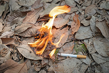
Cigarettes and Vehicles
In dry weather, even something small such as a cigarette can have big consequences.
- Never throw a lit cigarette out the window of a vehicle. It could land on dry grass or be blown into dry vegetation and start a fire.
- Never walk away and leave a cigarette burning. Always use an ash tray.
- Never park your vehicle on dry grass or leaves.
- Avoid driving through tall grass.
- Make sure spark arresters on the internal combustion engines of off-road vehicles are clean.
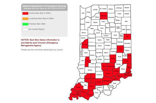
Indiana Burn Ban Status Map
Indiana Burn Ban Status Map
Burn Bans
Burn bans can be ordered by a local fire chief or by the legislative body of a town, city or county. The Indiana State Fire Marshal does not declare local burn bans, but the marshal does support local efforts to reduce the fire risk escalated by dry weather.
Burn bans that are reported by counties to the Indiana Department of Homeland Security are shown on the statewide burn ban map. Each county's emergency management agency is responsible for updating the status of its burn ban.
Because local jurisdictions, not the state, order and enforce local burn bans, individuals in a burn ban area should check with the local fire department or county officials for detailed instructions on what burning activities are temporarily disallowed.
Get Prepared