Location
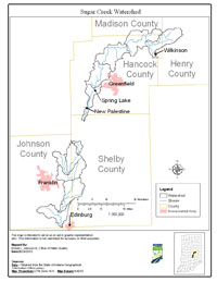
The Sugar Creek Watershed is located in eastern Indiana, draining approximately 170 square miles in Hancock, Henry, Johnson, Madison and Shelby counties. Major streams included in the Total Maximum Daily Load (TMDL) report are Sugar Creek, Barrett Ditch, Smith-Johnson Ditch, Broad Ripple Camp, Cutsinger Ditch, Gibson Ditch and Herriotts Creek.
History
A comprehensive survey of the Sugar Creek Watershed was conducted by Indiana Department of Environmental Management (IDEM) from July 2002 to October 2002. The primary cause of impairment is Escherichia coli bacteria (E. coli). Pollution sources in the watershed include nonpoint sources from agriculture and pastures, land application of manure and urban and rural run-off, as well as point sources from straight pipe discharges, home sewage treatment system disposal and combined sewer overflow outlets.
Pollutants Addressed
TMDLs for the Sugar Creek Watershed are established for E. coli and will address 13 impairments. Some of the recommended solutions to address the impairments include storm water controls, point source controls, manure management and habitat improvements.
Timeline
A kickoff TMDL meeting was held on January 24, 2006 at the Hancock County Extension Office, 802 North Apple Street, Greenfield starting at 6:00 p.m.
A draft TMDL meeting was held on July 18, 2006 at the Hancock County Extension Office, 802 North Apple Street, Greenfield starting at 6:00 p.m.
The 30-day public comment period for the draft Sugar Creek Watershed TMDL began on July 18, 2006 and ended on August 21, 2006.
U.S. EPA under Section 303(d) of the Clean Water Act approved the Sugar Creek Watershed TMDL report on March 14, 2007 for 12 impairments. TMDL reports identify and evaluate water quality problems in impaired water bodies and propose solutions to bring those waters into attainment with water quality standards.