The hydrologic unit code (HUC) is a numbering system for watersheds. It was developed by the U.S. Geological Survey (USGS) in cooperation with the U.S. Water Resource Council and the U.S. Department of Agriculture Natural Resources Conservation Service (NRCS) to provide a common coding system for state and federal agencies. Each unique HUC is attached to a specific watershed, enabling different agencies to have common terms of reference and agree on the boundaries of the watershed. These commonly understood boundaries foster understanding of how landscapes function, where water quality problems should be addressed, and who needs to be involved in the planning process.
The entire country has been mapped with three levels of HUCs: eight-digit HUCs for large watersheds known as sub-regions, 10-digit HUCs for watersheds, and 12-digit HUCs for smaller or sub-watersheds. There are over 2,200 eight-digit HUC sub-regions in the United States, with 39 located in Indiana. For example, all of the land area draining into the Upper White River is in one eight-digit HUC. The 10-digit HUCs divide the larger sub-region into watersheds, and the 12-digit HUCs divide the watersheds into sub-watersheds.
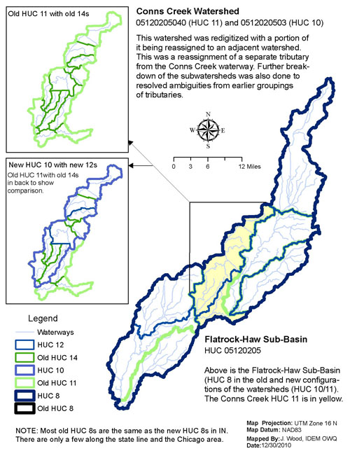
Before a standardized HUC system was developed, Indiana used 11-digit HUCs for watersheds and 14-digit HUCs for sub-watersheds. These delineations, or the processes which identify a watershed or other geographic characteristic, were completed by the Indianapolis USGS office in the mid-1990’s and were based on Indiana-specific characteristics of hydrography. The national USGS offices have since completed delineating the nation’s watersheds at the 10- and 12-digit HUC level, providing a seamless national map with consistency across state boundaries. The new system reduces confusion when dealing with watersheds that cross township, county, and state borders, but many states beside Indiana have documents that refer to older HUCs that must be adjusted into the new HUC system. Below is an example of how these differences may look at the watershed level and sub-watershed level.
The Indiana HUC Finder tool can assist you in finding current or old HUCs for your watershed.