Summary
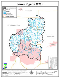
The Lower Pigeon Watershed (LPW) covers 68,700 acres in Vanderburgh, Gibson, Pike, and Warrick Counties in southwest Indiana. The LPW is made up of seven watersheds that each has a 12-digit Hydrologic Unit Code (HUC) area.
The main purpose of this plan is to outline goals and objectives designed to reduce runoff pollution from reaching the Ohio River and its tributaries. Runoff is generated when stormwater flows off farm fields, feedlots, and roads. Oils, bacteria, fertilizers, sediment, and other pollutants sitting on these surfaces get washed off by stormwater and enter the streams. These pollutants are deposited by normal everyday activities like lawn and garden maintenance, livestock production, agricultural practices, and construction. The stormwater carrying these pollutants can alter the temperature of the stream, damage aquatic habitat, and add sediment to the stream flow by scouring the channel and banks.
This Watershed Management Plan (WMP) was written to meet the requirements of the 2009 WMP checklist as defined by the Indiana Department of Environmental Management’s (IDEM) Section 319 Grant Program. Meeting IDEM standards allows stakeholders to apply for State grant money to improve the watershed. The creation of this plan is not government mandated and participation is voluntary.