CADDNAR
Frisinger v. Fettig (22-060W), 16 CADDNAR 25
Administrative Cause Number: 22-060W
Administrative Law Judge: Aaron W. K. Bonar
Petitioner Counsel: pro se
Respondent Counsel: pro se
Date: November 15, 2023
[See Editor’s note at end of this document regarding change in the decision’s original format.]
FINAL ORDER
1. Both Petitioners and Respondents are riparian owners, and thus have certain riparian rights, such as the ability to place a dock or pier into Loon Lake, associated with said ownership.
2. The area of Loon Lake on which both parties’ properties rest is a rounded bay. The determination of riparian boundaries is governed by the Fourth Principle of Information Bulletin 56 concerning the determination of riparian zones on rounded bays.
3. The parties’ respective riparian zones extend from their respective property lines on the shorefront to a central termination point in the middle of the rounded bay. Determining the exact boundaries of these riparian zones may require a new property and/or riparian survey of their respective properties.
4. Neither party may infringe on the other party’s riparian zone and must move their respective docks, including extensions and moor watercraft, to comply with this order.
5. The parties must maintain a safe navigation buffer zone from the riparian line dividing their respective riparian zones and the riparian zones of any adjacent properties. These zones must be clear of any docks, extensions, and moored watercraft at all times with the exception of temporary infringement caused by the entry to and exit from the parties’ respective riparian zones.
FINDINGS OF FACT AND CONCLUSIONS OF LAW WITH FINAL ORDER
Procedural Background and Jurisdiction
1. On September 9, 2022, Gregory E. and Deborah A. Frisinger (hereinafter Petitioners) filed correspondence (hereinafter Petition) with the Natural Resources Commission (hereinafter Commission) alleging that Todd and Tonya Fettig (hereinafter Respondents), John Holderman, and Todd Wittenberger infringed on Petitioners’ riparian zone by placing docks into or on the border of Petitioners’ riparian zone, and thus violated Petitioners’ riparian rights associated with that zone. See Petition.
2. Petitioners sought to have the offending docks moved away from their current locations to allow Petitioners to fully exercise their riparian rights. Id.
3. By filing their Petition, Petitioners initiated a proceeding governed by Indiana Code 4-21.5-3, sometimes referred to as the Administrative Orders and Procedures Act (AOPA) and the administrative rules adopted by the Commission at 312 IAC 3-1 to assist with the implementation of AOPA. See IC 4-21.5-3-1, et seq.
4. Administrative Law Judge (ALJ) Aaron Bonar was appointed under IC 14-10-2-2 to conduct this proceeding and was assigned this case on September 26, 2022.
5. A telephonic prehearing conference was set for October 24, 2022. John Holderman filed a Motion to Continue Telephonic Conference on October 12, 2022, which was granted on October 19, 2022. The telephonic prehearing conference was reset for November 3, 2022.
6. At the November 3, 2022 prehearing conference, the ALJ discussed the Shared Neutrals mediation program with the parties. By agreement of the parties, a referral was made to the Shared Neutrals program, but no mediator was available to mediate this matter. The case returned to the ALJ’s docket on February 3, 2023.
7. The ALJ set a telephonic status conference for March 3, 2023. John Holderman filed a Motion to Continue Telephonic Conference on February 20, 2023, but later informed the ALJ that he could appear at the March 3, 2023 telephonic conference.
8. At the March 3, 2023 telephonic status conference, the parties agreed to a hearing date of May 17, 2023. A final telephonic conference was set for May 10, 2023.
9. At the May 10, 2023 telephonic conference, Petitioners informed the ALJ that they had settled their disputes with John Holderman and Todd Wittenberger. The ALJ issued a Partial Order of Dismissal on May 10, 2023 removing John Holderman and Todd Wittenberger from this case.
10. The administrative hearing took place on May 17, 2023. The ALJ, Petitioners, and Respondents all appeared in person at the Natural Resources Commission Hearing Room at the Indiana Government Center in Indianapolis, Indiana. The Petitioners and Respondents were self-represented.
11. The following witnesses provided testimony at the administrative hearing: Gregory Frisinger, Alan Frisinger, Deborah Frisinger, and Todd Fettig.
12. Petitioners’ Exhibits A-K were admitted into the record without objection.
13. Respondents’ Exhibits 1-6 were offered for admission into the record. Exhibits 1-3 were admitted without objection. Exhibits 4-6 were not admitted into the record on Petitioners’ objection as they were filed after the deadline to file proposed exhibits.
14. Both parties were given the opportunity to file post-trial briefs in this matter. Petitioners filed a post-trial brief on June 9, 2023. Respondents did not file a post-trial brief.
Findings of Fact
15. Petitioners own real estate on Loon Lake in Whitley County, Indiana commonly identified as 5297 S. 600W-57, Columbia City, IN 46725. A portion of the property is an undeveloped lakefront property with a shoreline of approximately 102 feet. Petitioners have owned the property since October 2004. See testimony of Gregory Frisinger.
16. Petitioners maintain a dock extending into Loon Lake from their property. The dock extends approximately 42 feet into the lake but can reach a length of 52 feet if an addition is put on the lakeward end of the dock to accommodate Petitioners’ watercraft. The dock is approximately three and a half feet (3.5 feet) wide at its narrowest point and eight (8) feet wide at its widest point if the extension is attached to the dock. See testimony of Gregory Frisinger.
17. Respondents own real estate on Loon Lake in Whitely County, Indiana commonly identified as 5294 S. 600W-57, Columbia City, IN 46725. The property is a lakefront property with a shoreline of approximately 78 feet and is immediately north of the Petitioners’ property. Respondents have owned the property since August 2014. See testimony of Todd Fettig.
18. Respondents have maintained a dock on Loon Lake since 2014. Respondents’ previous dock was damaged by a fallen tree sometime in early July 2022. Respondents extended their current dock into Loon Lake sometime later in 2022. See testimony of Gregory Frisinger and Todd Fettig.
19. Respondents’ current dock is approximately 55 feet long, with 45-50 feet extending into Loon Lake depending on the lake level. It is approximately 40 inches wide at its narrowest point and 12 feet wide if an extension is attached to accommodate Respondents’ watercraft. See testimony of Todd Fettig.
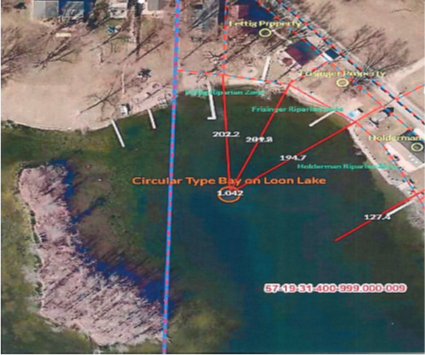
20. Petitioners testified that Respondents’ current dock, including the extension for Respondents’ watercraft and the watercraft themselves, crosses into their riparian zone and thus prevents them from fully exercising the riparian rights associated with their shoreline. See testimony of Gregory and Deborah Frisinger and Exhibits A, B, and J.
21. Petitioners’ testimony is based on Petitioners’ belief that their riparian zones effectively extend out into Loon Lake from their onshore property lines in a straight line, roughly following the last section of the Fourth Principle of Information Bulletin 56. See generally Information Bulletin 56: Riparian Zones within Public Freshwater Lakes and Navigable Rivers (Third Amendment), DIN 20220209-IR-312220025NRA (IB56; discussed in detail below) and Exhibit H.
22. Petitioners presented several alternative placements for Respondents’ dock that would comply with the section of Principle Four of IB56 that they believe governs the boundaries of their riparian zones. See Exhibits C-E.
23. Further, Petitioners testified that Respondents do not have a prescriptive right to continually place their dock in its current configuration, which Petitioners believe infringes on their riparian zone. Petitioners seem to be arguing that Respondent does not have a prescriptive easement to cross into Petitioners’ riparian area, though this was unclear from the testimony as Petitioners referred more generally to the right to place and maintain a pier or dock into a public freshwater lake. See testimony of Alan Frisinger.
24. Respondent Todd Fettig testified that the current dock is in the same location as the previous dock, and that the previous owners of the Fettig property maintained their dock in a configuration similar to the current dock without any objections from Petitioners. See testimony of Todd Fettig.
25. Respondents, aside from testifying that they had a previous dock in a similar configuration, did not argue that they had a prescriptive easement burdening Petitioners’ property or riparian zone. Id.
26. Respondents testified that, contrary to Petitioners’ belief, the riparian zones should be determined in accordance with a different section of IB56’s Fourth Principle. The section Respondents reference governs how riparian zones are determined on a substantially round lake or bay. Respondents included photographs overlaid with self-drawn riparian boundaries to illustrate their opinion on how the riparian lines should be drawn. See Id. and Exhibits 1-3.
27. Respondents further testified that Petitioners brought this action, at least in part, because Petitioners wish to move their dock closer to Respondents’ riparian area and are trying to get an order requiring Respondents to move their dock to accommodate Petitioners’ proposed new dock placement. See testimony of Todd Fettig.
28. Neither party presented recent surveys that determined their property lines and/or riparian areas associated with their lakefront properties.[1] Thus, both parties’ assertions regarding how to determine or draw riparian boundaries were based on opinion and on their respective interpretations of IB56. See totality of the record.
Conclusions of Law
- Loon Lake is a Public Freshwater Lake located in Whitley County and Noble County, Indiana. See Information Bulletin #61: Listing of Public Freshwater Lakes (Eighth Amendment), DIN 2021020-IR-312210447NRA.
- IC 14-26-2-5, also known as the Lake Preservation Act, provides that the State “has full power and control of all the public freshwater lakes in Indiana … [and] holds and controls all public freshwater lakes in trust for the use of all of the citizens of Indiana for recreational purposes.” See IC 14-26-2-5(d)(1-2).
- The Commission has jurisdiction over public freshwater lakes and has the power to make administrative rules to implement relevant sections of the Indiana Code. See IC 14-10-2, 14-15-7-3, 14-26-2-23, and 4-22-2.
- A “riparian owner” is “the owner of land, or the owner of an interest in land sufficient to establish the same legal standing as the owner of land, bound by a lake.” 312 IAC 11-2-19.
- In general, the owner of property that abuts a lake possesses certain rights associated with ownership of that property. Bass v. Salyer, 923 N.E.2d 961, 971 (Ind. Ct. App. 2010). Those rights include “1) the right of access to navigable water; (2) the right to build a pier out to the line of navigability; (3) the right to accretions; and (4) the right to a reasonable use of the water for general purposes . . ..” Parkison v. McKue, 831 N.E2d 118, 128 (Ind. Ct. App. 2005).
34. The arguments in this matter regarding prescriptive rights are largely irrelevant. It is not disputed that both parties own real estate abutting Loon Lake. Thus, both parties are riparian owners. As such, they each are permitted to extend a qualifying temporary structure, such as a pier or dock, lakeward of the shoreline of Loon Lake. See Id and 312 IAC 11-3-1(b).
35. Thus, the remaining disputed issues are the determination of the boundaries of each party’s respective riparian zone and whether Respondents’ dock placement infringes on Petitioners’ riparian zone.
36. The area in which both parties’ real estate rests appears to be a circular, horseshoe shaped bay. See image excerpt below from Exhibit 2. Respondents’ testimony that that the small island on the left side of the image renders its surrounding area unnavigable was not disputed. The ALJ concludes from this testimony that the area is a rounded bay with only one entry point and exit point from the bay to the open water of the lake.
37. Petitioners and Respondents agree that IB56’s Fourth Principle should govern their riparian boundaries. They merely disagree on which section of the Fourth Principle should be the controlling section. Petitioners believe that the following section should govern the determination of both parties’ riparian boundaries:
If the navigable waterfront borders a long lake or other public waters that are not substantially round, the boundaries of the riparian zones may be formed by running a line through the center of the public waters, with deflected lines run from each owner's shore boundaries to intersect the centerline at perpendiculars.
See IB56, page 5.
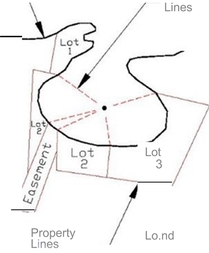
38. Petitioners submitted the following image from IB56 along with their explanation in support of their arguments regarding how the riparian boundaries should be drawn:
See Exhibit H.
39. As determined in paragraph 36, the area on which both parties own real estate is substantially round. Thus, the following section of IB56’s Fourth Principle controls:
If the navigable waterfront borders a lake that is substantially round or is a bay that is substantially round except for its connection to the main body of the public waters, the riparian zones may be formed by running lines from each owner's shore boundaries to the center of the lake or bay. …
See IB56, pages 5-6.
40. The parties’ respective riparian boundary lines do not extend in a straight line from their respective property lines. Rather, the riparian zones are “pie shaped,” extending from the parties’ respective property lines to a central point in the middle of the round bay.
41. Given this finding, the second issue of whether Respondent’s dock infringes on Petitioners’ riparian zone largely turns on how Respondents’ dock is situated on Loon Lake. So long as Respondents’ dock, including any extensions and moored watercraft, is reasonably within Respondents’ pie-shaped riparian zone, Respondents’ dock will not infringe on Petitioners’ riparian zone.
42. Petitioners raised a question of whether Respondents’ dock was of a reasonable length, as Petitioners claimed that Respondents’ dock crossed into their riparian area. A determination of the reasonableness of the Respondents’ dock length cannot be made based on the evidence presented at the hearing.
43. 312 IAC 11-3-1 provides a general license to riparian owners to place a temporary structure, such as a pier or dock, onto a public freshwater lake. One requirement of this rule is that a pier or dock “[n]ot be unusually wide or long relative to similar structures within the vicinity on the same public freshwater lake.” Without more evidence as to surrounding structures on Loon Lake and evidence of the extent of the parties’ respective riparian zones, the ALJ cannot make a finding on this issue. See 312 IAC 11-3-1.
44. Both parties are ordered to arrange their docks in a manner consistent with IB56’s instructions when the navigable waterfront borders a lake that is substantially round or is a bay that is substantially round except for its connection to the main body of the public waters and in such a way that the docks are wholly located within the party’s respective riparian zone.
45. Pursuant 312 IAC 11-3-1, the parties’ docks must be placed so as to not infringe on the access of any adjacent landowner to the Lake and in a manner that does not unduly restrict navigation. Both parties are therefore ordered to maintain sufficient clear space between their two docks and the docks of any adjacent property owners as directed in IB56.
46. The exact dimensions of the parties’ respective riparian zones cannot be determined from the evidence presented at the hearing. A property and/or riparian survey may be needed to accurately establish the parties’ riparian zones in a manner consistent with this order.
[EDITOR’S NOTE: The original format of the Administrative Law Judge’s Findings of Fact, Conclusions of Law, and Final Order has been modified to correspond with CADDNAR format. The Final Order has been relocated to the beginning of this document.]