CADDNAR
Frazzetta v. Kreft, Lomperski, & Wagoner (22-043W), 16 CADDNAR 16
Administrative Cause Number: 22-043W
Administrative Law Judge: Elizabeth Gamboa
Petitioner Counsel: Steven Snyder
Respondent Counsel: T. Andrew Perkins, Counsel for Krefts
Robert Eherenman, Counsel for Lomperskis
Date: May 15, 2023
[See Editor’s note at end of this document regarding change in the decision’s original format.]
FINAL ORDER:
87. Krefts’ pier encroaches on Frazzettas’ riparian area and must be moved in accordance with the riparian line established by the Michel survey.
88. Lomperskis’ request to order Krefts to move the pier back to its historic location is denied.
89. Unfortunately, this order may lead to additional conflict between the co-owners of the Easement. It is hoped that the Easement co-owners can reach and equitable resolution of the use of the pier without the need for further litigation.
FINDINGS OF FACT AND CONCLUSIONS OF LAW WITH FINAL ORDER
Procedural Background and Jurisdiction:
1. On June 27, 2022, Anthony and Elizabeth Frazzetta, as Trustees of the Anthony and Elizabeth Frazzetta Living Trust (Frazzettas), by counsel Stephen Snyder, filed a Petition for Administrative Review. Frazzettas alleged the pier maintained by Respondents Gerald and Shari Kreft (Krefts), David and Elizabeth Lomperski (Lomperskis) and Christopher and Kelee Wagoner (Wagoners) interfered with Frazzettas’ riparian zone and with navigation. See Petition for Administrative Review (Petition).
2. A copy of the Petition was provided to each of the respondents with Notice of Telephonic Prehearing Conference (PHC) scheduling a PHC for July 22, 2022.
3. Frazzettas, Krefts and Lomperskis appeared at the PHC. Wagoners failed to appear.
4. A case management order was established at the PHC which scheduled the administrative hearing on October 7, 2022.
5. A notice of proposed default was issued against the Wagoners on July 21, 2022 for failing to appear at the PHC.
6. Robert Eherenman filed an appearance with the Commission on behalf of the Lomperskis and a Motion to Continue on September 7, 2022. By order dated September 12, 2022, the case management order entered July 22, 2022, was vacated, along with the October 7, 2022 administrative hearing date.
7. A Final Order of Default was issued against the Wagoners on September 12, 2022.
8. A Telephonic Status Conference (TSC) was held October 11, 2022 at which Lomperskis’ counsel indicated he would be filing a crossclaim against the Krefts. A case management order was established by agreement of the parties and an administrative hearing was scheduled for March 1, 2023.
9. On October 14, 2022, Lomperskis filed a crossclaim against the Krefts, alleging Krefts unilaterally moved the “common pier” shared by Krefts and Lomperskis, resulting in interference with Lomperskis’ riparian rights. See Cross-Claim for Administrative Review.
10. T. Andrew Perkins filed an appearance on behalf of Krefts on November 4, 2022.
11. A final TSC was conducted February 7, 2023.
12. The parties filed a Stipulation of the Parties on February 20, 2023.
13. An Administrative Hearing was held on March 1, 2023 in the hearing room of the Natural Resources Commission, Division of Hearings. Anthony and Elizabeth Frazzetta appeared in person and by counsel, Stephen Snyder. Gerald and Shari Kreft appeared in person and by counsel, T. Andrew Perkins. David and Elizabeth Lomperski appeared in person and by counsel, Robert Eherenman. Sworn testimony was taken and exhibits were admitted into evidence. The parties provided opening and closing statements. By agreement of the parties, no post-hearing briefs were filed.
14. The following exhibits were admitted at the hearing by stipulation:
a. Petitioners’ Exhibits A through CC
b. Kreft Exhibits K1-K7, on the condition any writing on the photographs would not be considered.
c. Lomperski Exhibits 1-6.
15. The Lomperskis’ exhibit K10 was admitted into evidence at the hearing
without objection.
16. The following witnesses were duly sworn and testified at the hearing: Anthony Frazzetta, David Lomperski, and Gerald Kreft.
17. By filing a request for Administrative Review, Frazzettas initiated a proceeding governed by Ind. Code 4-21.5-3 and 312 IAC 3-1.
18. Tippecanoe Lake in Kosciusko County is a Public Freshwater Lake. Ind. Code § 14-26-2-3; Ind. Code § 14-26-2-24; Listing of Public Freshwater Lakes, Information Bulletin # 61 (Seventh Amendment), June 22, 2017, DIN 20170531-IR-312170269NRA (“IB 61”).
19. The Commission is the ultimate authority with respect to the subject matter of this proceeding. Ind. Code § 14-26-2-23(e)(3).
20. The Commission has jurisdiction over the parties and the subject matter of this proceeding. Id.
FINDINGS OF FACT:
21. Frazzettas purchased real estate adjacent to a channel of Tippecanoe Lake, in Steuben County, commonly known as 35 EMS T17A Lane, Leesburg, IN, (Frazzetta Tract) in 2006. See Testimony of Anthony Frazzetta (“Frazzetta”).
22. Frazzettas maintain a pier in their riparian area and have moored as many of three boats and a couple of wave runners to the pier. Frazzettas currently moor one watercraft to their pier. Id.
23. Krefts purchased property commonly known as 93 EMS T18 Lane, Leesburg, IN in 2019. See Testimony of Gerald Kreft (“Kreft”), Exhibit F.
24. David and Elizabeth Lomperski purchased property commonly known as 103 EMS T18 Lane, Leesburg, IN in 2020. See Testimony of David Lomperski (“Lomperski”), Exhibit E.
25. Wagoners own property adjacent to the lots owned by Krefts and Lomperskis. Wagoners purchased their property in 2004. See Exhibits D and J.
26. The properties owned by Krefts, Lomperskis and Wagoners are in Wildwood Heights Addition and are not adjacent to Tippecanoe Lake or to the channel on which Frazzettas’ property is located. See Exhibit J.
27. The southernmost portion of the Frazzetta Tract is burdened by an easement (Easement) with 50 feet of lake frontage, in favor of lot owners in Wildwood Heights Addition – Krefts, Lomperskis and Wagoners. See Exhibits B and C.
28. The Easement includes the rights of “ingress and egress” from the channel and includes “the right and privilege to tie a boat and install a boat pier at the waters [sic] edge at said channel, so long as the same does not unreasonably obstruct or interfere with the use of said channel by others.” Id. The terms of the Easement are included below.
29. Wagoners have lake access at a different location and do not use the Easement. See Testimony of Frazzetta.
30. The Krefts’ and the Lomperskis’ predecessors in interest shared a pier (shared pier) that was maintained at roughly the same location as shown in aerial photographs from 2005, 2011, 2013, and 2016. See Testimony of Lomperski, Testimony of Kreft; Exhibit 2.
31. The shared pier was approximately three feet wide. See Testimony of Lomperski.
32. Frazzettas’ Exhibit J, a portion of which is embedded below, shows relationship between the Easement and the Frazzetta tract, as well as the shared pier located within the Easement:
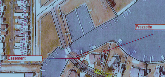
Exhibit J.
33. A seawall runs along the shoreline of the Frazzetta tract. The seawall terminates south of the northern boundary of the Easement, at a point on the shoreline that angles east approximately ninety degrees. See Testimony of Frazzetta; Testimony of Lomperski; and Exhibit 2.
34. Not visible in this picture is a set of stairs located south of the seawall. See Testimony of Frazzetta, Testimony of Lomperski, Testimony of Kreft, and Exhibit M.
35. From at least 2006 to September 2022, the shared pier extended into the channel lakeward of the steps and roughly parallel to the portion of the seawall that angles east. This placement resulted in the pier extending north, away from the culvert under the bridge on EMS T17A LN, as indicated in Exhibit J. This location is referred to as the historic location of the pier. See Testimony of Frazzetta; Testimony of Lomperski; and Exhibit 2.
36. The piers in the boat channel across from Frazzettas’ tract are used by residents of a mobile home park. See Testimony of Frazzetta.
37. Lomperskis’ predecessors used the south side of the pier whereas Krefts’ predecessors used the north side of the pier. Lomperskis and Krefts continued this practice. See Testimony of Lomperski.
38. In addition to the shared pier, Lomperskis and Krefts each maintain a jet ski on floats in the water south of the shared pier. See Testimony of Lomperski, Testimony of Kreft, and Exhibit 5.
39. The water level in the culvert flowing under the bridge is generally lower than that of the rest of the channel. Boaters not familiar with the channel will often turn around in the Easement riparian zone rather than navigating through the culvert. See Testimony of Frazzetta, Testimony of Lomperski.
40. A survey of the Easement was prepared to confirm the northern boundary of the easement before Krefts purchased their property. The surveyor marked the boundary between the Easement and Frazzettas’ property with a red mark on Frazzettas’ seawall. See Testimony of Frazzetta.
41. Frazzetta later painted the mark white to make it more visible. Id.
42. In 2022, Krefts installed a boat lift on the north side of the shared pier, still in its original location. See Testimony of Frazzetta, Testimony of Kreft.
43. Frazzettas filed a request for a hearing after the boat lift was installed, alleging the lift encroached on his riparian zone. See Testimony of Frazzetta.
44.Kevin Michel prepared a survey of the Easement in September 2022. Michel confirmed that the mark placed on Frazzettas’ seawall by the previous surveyor was accurate. Michel also extended the riparian boundary between the northern limit of the Easement and the remainder of the Frazzetta tract. The parties stipulated to the Michel survey and to the location of the riparian boundary as indicated in the survey as follows:
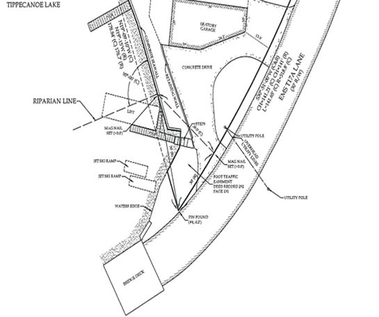
Exhibit I.
45. Michel’s survey located the Shared Pier at its historic location as well as the location of Lomperskis’ and Krefts’ jet skis. See Testimony of Frazzetta and Exhibit I.
46. The Michel survey shows that Krefts’ boatlift extended beyond the length of the Shared Pier into Frazzettas’ riparian zone at the pier’s historic location. See Exhibit I.
47. Sometime in September, 2022, Krefts removed the shared pier and installed a new pier, with a boat lift, a few feet north of the historic location of the shared pier. At the new location, the pier was attached to the north-south portion of Frazzettas’ seawall. As a result, the new pier extends into the channel in a southerly direction. See Testimony of Frazzetta, Testimony of Lomperski.
48. On October 22, 2022, after Kreft installed the new pier, Frazzetta took measurements using the established Easement boundary and laser projections on to the pier. Frazzetta determined the lift – which was attached to the pier - was 15 inches north of the riparian boundary as established by Michel. See Testimony of Frazzetta and Exhibit CC.
49. While the new pier does not currently interfere with Frazzettas’ navigation, it could in the future if the Frazzettas decide to moor additional watercraft in their riparian area. Testimony of Frazzetta.
50. Kreft testified he doubted the pier encroached into Frazzettas’ riparian zone; however, Kreft’s testimony was not supported by additional evidence, such as a survey. Further, Kreft stipulated to the survey as establishing the riparian boundary between the Easement and the Frazzetta property. See Testimony of Kreft. Kreft’s testimony that there was no encroachment is given little weight.
51. Krefts’ pier and the boatlift are approximately 13 feet wide. See Testimony of Kreft.
52. There was no evidence presented as to the width of the Lomperskis’ boat or of the jet skis.
53. Lomperskis’ Exhibit 6, a video tape of Lomperski mooring his boat after the new pier was installed demonstrates the navigational challenges Lomperskis face when mooring his boat to the new pier. See Testimony of Lomperski and Exhibit 6.
54. There was no agreement between Kreft and Lomperski to share the cost of the pier or the cost of its installation. See Testimony of Lomperski, Testimony of Kreft.
55. Kreft moved the pier because the attorney with whom he consulted advised him to do so. See Testimony of Kreft.
56. Kreft spent approximately $10,000 on the new pier and its installation. Id.
CONCLUSIONS OF LAW:
A. Does Krefts’ pier encroach on Frazzettas’ riparian zone?
57. Pursuant to Ind. Code 14-26-2-23(e)(3), the Commission established a process for the mediation of disputes among person with completing interests along the shoreline of public freshwater lakes. The Commission adopted 312 IAC 11-1-3 which authorizes a person to initiate a proceeding controlled by IC 4-21.5 and 312 IAC 3 to resolve a dispute among riparian owners concerning the usage of an area over, along, or within a shoreline or waterline of a public freshwater lake. 312 IAC 11-3-2.
58. The burden of proof is on Frazzetta to show encroachment into his riparian area.
59. Krefts’ boat lift is considered an extension of the pier.
60. As shown in the Michel survey, the pier at its historic location encroached on Frazzettas’ riparian zone.
61. Frazzettas’ observations and measurements in October, 2022 indicate that the new pier also encroaches on Frazzettas’ riparian zone.
62. Neither Krefts nor Lomperskis presented credible evidence to refute Frazzettas’ calculations of encroachment.
63. Frazzettas have met their burden of establishing encroachment. Frazzettas’ request that the new pier be moved so that it does not encroach on Frazzettas’ riparian area is granted.
64. Krefts requested the ALJ consider their good faith efforts in resolving the dispute prior to the hearing as well as the investment they made in the pier and deny Frazzettas’ request.
65. Krefts request has no support in the law. It would be setting dangerous precedent to forgive a party for encroaching on another’s riparian zone based on the amount of money the party has spent to do so. Further, Krefts changed the location of the pier after the present dispute was initiated, yet Krefts did not seek guidance from the Commission, or, it appears, consult with opposing counsels.
66. Krefts must move their pier so that no part of the pier, including the boatlift and any watercraft moored to the pier, encroaches on Frazzettas’ riparian zone as established by the Michel survey.
B. Should Krefts be ordered to move their pier back to the original location because the pier in its new location interferes with Lomperskis’ riparian rights?
67. In their cross-claim against Krefts, Lomperskis assert that Lomperskis and Krefts “each have shared riparian rights to maintain a common pier lakeward” of the shoreline of the Easement, and that Krefts have “unilaterally altered the location of the common pier shared with Lomperskis in such a manner as to interfere with and burden the riparian rights of Lomperskis.” See, Cross-Claim for Administrative Review, p. 2.
68. Lomperskis requested the Krefts be ordered to move the pier back to the historic location. Id.
69. There is no dispute that Krefts and Lomperskis enjoy “the right and privilege to tie a boat and install a boat pier at the waters [sic] edge” of the channel in the Easement area. See Exhibit C.
70. Lomperskis’ cross-claim assumes that the Easement documents require any pier extended within the Easement to be shared by the owners of the Easement.
71. Lomperskis presented no evidence in addition to the Easement documents to prove the maintenance of a shared pier is contemplated by those documents.
72. The clear language of the documents creating the Easement controls. See Parkison v. McCue, 831 N.E2d 118 (Ind. Ct. App. 2005); Cress v. Byrer (Remand), 14 CADDNAR 81, 82 (2016).
73. The Easement was created by David Carey in 1991through a warranty deed and the affidavit of David L. Carey. The warranty deed conveyed a non-exclusive easement over what is now the Frazzetta tract to Gerald and Gloria Williams. The deed includes the metes and bounds description of the Easement and provides that the
easement shall inure to the benefit and use of the Grantees herein and their heirs, devisees, personal representative, successors and assigns for means of ingress to and egress from the certain channel connecting Tippecanoe Lake and to run with and for the benefit of the tract of real estate first described above and conveyed to the grantees herein, and said easement shall be used by foot and not any vehicular travel, to remain open and unobstructed, and it shall be used in common with the owners of those other tracts of real estate consisting of unplatted residential lots in an area known as “Wildwood Heights Addition” as particularly set forth in the Affidavit of David L. Carey recorded on September 27, 1991. . . and it shall include the right and privilege to tie a boat and install a boat pier at the waters [sic] edge at said channel so long as the same does not unreasonably obstruct or interfere with the use of said channel by others.
See Exhibit B, emphasis added.
74. The Affidavit of David L. Carey includes the metes and bounds description of the Easement and contains the same paragraph quoted above. The Affidavit also describes the area known as “Wildwood Heights Addition.” See Exhibit B.
75. Nothing in the Easement or the Affidavit requires the owners of the Easement to share a pier.
76. The only reference to “common use” in the Easement is in describing the terms of the Easement itself. The phrase “it shall be used in common” appears in the sentence describing the use for the Easement. The word “it” in the phrase, therefore, refers to the Easement itself and requires the Easement to be used in common among its owners.
77. The rights granted each Easement owner “shall include the right and privilege to tie a boat and install a boat pier at the waters [sic] edge.” There is no requirement in the Easement language that the owners of the Easement share a pier.
78. It appears previous Easement owners were able to share the pier in an amicable manner. The fact that the previous owners shared the pier does not require a finding that the Easement owners are required to maintain a common pier.
79. The Krefts and Lomperskis have not entered into an agreement to share a pier. Absent the requirement to do so in the Easement or an agreement to do so, Krefts are not required to share their pier with other Easement owners.
80. The Easement owners’ right to place a pier in the Easement riparian zone is not unlimited. None of the owners may unreasonably obstruct or interfere with the use of the channel by Lomperskis. Further, the Easement does not grant the owners the right to maintain an unlimited number of watercrafts in the water.
81. All the parties testified that the channel is crowded with boat traffic. Angling the pier toward the more crowded areas of the channel could present a challenge for the Krefts.
82. Further, the boat lift extends into the channel beyond the end of the pier, causing further navigational challenges. Lomperski has to make a fairly sharp left turn in order to pull alongside the pier, causing additional navigational challenges.
83. It is unclear from the evidence, however, whether Krefts’ pier is the sole cause of Lomperskis’ navigational challenges. Lomperskis’ Exhibit 6 shows there is little room to spare between the pier and the jet skis in the water south of the pier. There is no evidence presented as to whether removing the jet skis from the water would alleviate at least some of Lomperskis’ navigational challenges.
84. The evidence of whether the water level is high enough for navigation of a boat on the south side of the channel is conflicting. Lomperski testified the water gets shallower closer to the culvert. Kreft testified the water level along the shoreline of the Easement is sufficient deep for mooring of Lomperskis’ boat.
85. Krefts have been ordered to move their pier because it infringes on Frazzettas’ riparian zone. It would be speculative to conclude that the future placement of Krefts’ pier would unreasonably obstruct or interfere with Lomperskis’ use of the channel on the evidence presented by the parties.
86. Lomperskis request that Krefts be ordered to return the pier to its historic placement is denied.
[EDITOR’S NOTE: The original format of the Administrative Law Judge’s Findings of Fact, Conclusions of Law, and Final Order has been modified to correspond with CADDNAR format. The Final Order, Paragraphs 87 through 89, has been relocated to the “Final Order” section at the beginning of this document.]