CADDNAR
[CITE: Rehlander v. Lenzen. et al. & Amelio, 15 CADDNAR 115 (2020)]
Cause #: 18-059W
Caption: Rehlander v. Lenzen, Templin, Dempsey Trust, & Kaminski, & Amelio
Administrative Law Judge: D. Wilson
Attorneys: J. Kaminski for Petitioners; G. Ivancevich for Respondents; G. Hancock for Intervenor
Date: September 15, 2020
[Editor’s Note: Final Order follows Findings of Fact and Conclusions of Law.]
FINDINGS OF FACT AND CONCLUSIONS OF LAW
WITH FINAL ORDER
Statement of the Proceeding and Jurisdiction
1. Raymond Rehlander (“R. Rehlander”) filed correspondence on June 12, 2018, requesting a “ruling regarding a property/lake right dispute.” The request failed to name any opposing party and R. Rehlander was allowed the opportunity to amend his submission. On June 21, 2018, Robert Lenzen (“Lenzen”), Marvin Templin (“Templin”), Robert Dempsey Trust (“Dempsey Trust”) and Wieslaw Kaminski (“Kaminski”) were named as respondents by the Petitioner.
2. The Petition, along with the supplemental filing by R. Rehlander, initiated a proceeding governed by Ind. Code 4-21.5-3, sometimes referred to as the “Administrative Orders and Procedures Act” (“AOPA”) and the administrative rules adopted by the Commission at 312 IAC 3-1 to assist with the implementation of AOPA.
3. Administrative Law Judge (“ALJ”) Dawn Wilson was appointed under IC 14-10-2-2 to conduct this proceeding.
4. On July 5, 2018, Nicholas Amelio (“Amelio”) submitted a request to be identified as an intervening party. By ALJ order, Amelio was subsequently added as an intervening party.
5. On July 18, 2018, following the issuance of notice to all parties, ALJ Wilson conducted a Prehearing Conference, with R. Rehlander, Amelio and Lenzen attending. In addition, a Status Conference was held on August 15, 2018, with all parties present.
6. Thereafter, R. Rehlander and Kimberly Rehlander (the “Rehlanders”) requested the inclusion of Kimberly Rehlander as an additional Petitioner, due to her ownership in property relevant to this proceeding. The ALJ granted the request for Kimberly Rehlander to intervene as a party to this proceeding (“K. Rehlander”).
7. On July 30, 2018, the Department of Natural Resources (“Department”) by Counsel Elizabeth Gamboa and Ihor Boyko, filed its “Joint Appearance of Counsel for Department of Natural Resources for a Limited Purpose and Request for all Filings, Discovery Requests, Notices, Reports, and Orders”. For the reason that the Department is entrusted to hold and control public freshwater lakes for the benefit of the public pursuant to IC 14-26-2-5, the Department’s request was granted on August 2, 2018. On March 4, 2020, Attorney Gamboa filed a Notice of Withdrawal of Counsel. The Department did not seek to intervene.
8. On August 14, 2018, Arthur Johnson appeared as counsel for Lenzen, Templin, the Dempsey Trust and Kaminski. On October 3, 2019, George Ivancevich filed his substitution of appearance on behalf of Lenzen, the Dempsey Trust and Kaminski. On January 28, 2020, on behalf of Templin, George Ivancevich substituted his appearance.
9. On August 13, 2018, James Kaminski[1] filed his appearance as counsel for the Rehlanders.
10. On July 30, 2019, Gary Hancock filed his appearance as counsel for Amelio,
11. On July 24, 2018, motions to dismiss were filed by Amelio and Lenzen. On August 7, 2018 and August 31, 2018, the Rehlanders responded to the motions. Thereafter, party replies were filed by Amelio and Lenzen.
12. On August 2, 2018, the ALJ determined that the motions to dismiss would require treatment as motions for summary judgment under Indiana Trial Rule 56, as directed by Indiana Trial Rule 12(C). Pursuant to IC 4-21.5-3-23, AOPA requires an ALJ to consider motions for summary judgment as a court would consider a motion for summary judgment filed under Trial Rule 56.
13. On November 21, 2018, the ALJ issued an “Interlocutory Order on Motions for Summary Judgment” (“OSJ”) and granted summary judgment, in part. The OSJ is incorporated by reference as if stated herein and the matters established on summary judgment are affirmed.
14. Following issuance of the OSJ, upon party objection, Finding of Fact number 35 within the OSJ was amended to remove the phrase “that includes 77.5 feet of frontage”. The OSJ resolved some, but not all, of the pending disputed issues presented in the proceeding.
15. On March 5, 2019, a mediator was appointed in this proceeding. On June 25, 2019, the mediator reported mediation was unsuccessful.
16. Following multiple status conferences and the imposition of prehearing deadlines, an administrative hearing was heard on March 12, 2020. The administrative hearing was conducted in the hearing room of the Commission’s Division of Hearings offices in Indianapolis, Indiana, with all parties present in person and by counsel.
17. Following the presentation of evidence, the ALJ allowed each party the opportunity to provide closing arguments in written form on or before April 17, 2020. On April 17, 2020, the Rehlanders, by counsel, filed “Petitioners’ Memorandum of Law”. On that same date, Amelio, by counsel filed a “Post Hearing Brief of Intervenors” and Respondents, by counsel, filed a “Brief of Respondents.”
18. The Lake Preservation Act places full power over public freshwater lakes in the State of Indiana. The State, through the Department, is responsible to “hold and control all public freshwater lakes in trust for the use of all the citizens of Indiana for recreational purposes.” IC 14-26-2-5(d), Indiana Dept. of Nat. Res. v Lake George, 889 N.E.2d 361 (Ind. App. 2008) and Lake of the Woods v Ralston, 748 N.E.2d 396, 401 (Ind. App. 2001).
19. The Commission has adopted rules at 312 IAC 11 to assist with administration of the Lake Preservation Act. IC 4-21.5-1-15 and 312 IAC 3-1-2.
20. Under IC 4-21.5, the Commission is responsible for resolving “a dispute among persons with competing riparian interests” associated with a public freshwater lake. Id
21. In addition, “A person may seek administrative review of the placement or maintenance of a structure under [312 IAC 11-3-1 or 1.2]…of this rule.” 312 IAC 11-3-2.
22. The Commission is the “ultimate authority” for determinations under the Lake Preservation Act. IC 4-21.5-1-15 and 312 IAC 3-1-2.
23. The Commission has jurisdiction over the subject matter and over the persons of the parties in this proceeding.
Findings of Fact[2]
24. The following undisputed findings of fact were determined though summary judgment:
(a) Bass Lake is a public freshwater lake in Starke County, Indiana.
(b) Rehlander has an interest in real property on Bass Lake.
(c) Joseph Krivak was a prior owner of property now owned by Rehlander.
(d) Amelio has an interest in real property fronting on Bass Lake that is immediately adjacent to and north of the Rehlander property.
[VOLUME 15, PAGE 116]
(e) On March 20, 1992, a Declaratory Judgment was issued by the Fulton County Circuit Court in Joseph Krivak and Emily Krivak v Robert Dempsey, et al, cause number 25C01-9105-CP-0178 (the “Declaratory Judgment”). In the Declaratory Judgment, property owners of Lots 2 through 12 of Krivak Acres were determined to be the owners of a 20 foot easement (“Easement Holders”) across the north end of Krivak’s property, more specifically:
Beginning at a point on the meander line of Bass Lake (formerly Cedar Lake), 43 feet north of the northwest corner of Lot 16 in Shoup’s Addition to Shoup’s Cedar Lake Lots; thence north 90 feet along the meander line of said lake; thence east to the west line of public highway; thence south along said highway to a point where said highway intersects the north line of tract conveyed to Victor O. McDowell and wife as shown by deed recorded in Deed Record 90, page 475; thence west along the north line of McDowell tract to place of beginning.
See “Response to Motion for Summary Judgment” (“Petitioners’ Response”), Ex.1.
(f) Easement use, as described in the Declaratory Judgment, was limited to use by the property owners of Lots 2 through 12 of Krivak Acres, their guests of the day and tenants of the property owners. Petitioners’ Response, Ex.2.
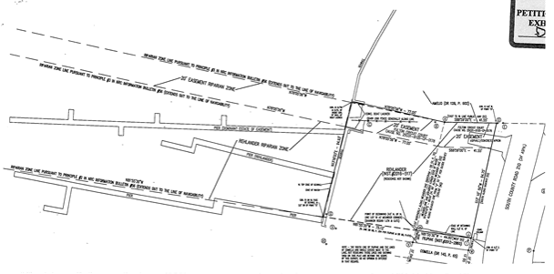
(g) In the Declaratory Judgment, the easement was determined by the court to “provide reasonable access to [Bass Lake] in a manner not unduly limiting usage by the other easement owners.” Id. at pg. 2.
(h) The Fulton Circuit Court also determined that reasonable access included the “installation and maintenance of a pier by participating property owners; for installation and maintenance of shore stations or buoys for mooring boats. Selection of a location for the pier, for shore stations, or for buoys shall be as the property owners may from time to time agree based upon their need and reasonable usage for all. This in no way limits the property owners in the selection of a location for the placement of their pier other than to allow for reasonable usage of the lake by all users…Such other rights of access as may be reasonable under the circumstances or as a court of proper jurisdiction may from time to time determine.” Id. at pg. 2.
(i) In the Declaratory Judgment, the Court’s order included the following instruction, “counsel for defendants shall make appropriate permanent record in Starke County of this Court’s ruling, either by filing of this ruling by lis pendens, by recording in the miscellaneous records of Starke County, or both.” Id. at page 3. The Court declared the dominant and servient estate ownership “shall be covenants running with the land.” Id.
(j) On August 31, 1992, the Department issued Permit PL-14,911 to Robert Dempsey for the installation of a temporary pier. Permit PL-14,911, included the following conditions, “the temporary pier shall extend lakeward from the legal shoreline starting approximately 8 feet south of the north line of the 20-foot easement…the temporary pier shall remain parallel to the easement lines extended into the waters of Bass Lake…the maximum width of the pier shall be 3 feet…no pier segments shall extend in a perpendicular direction from the pier…all watercraft shall be moored parallel to the pier.” Petitioners’ Response, Ex. 2, pgs. 6-7 and Ex. 4, pgs. 1-2.
(k) On September 11, 1992, Joseph Krivak filed a petition requesting administrative review of Condition 7[3] of his own permit for a temporary pier, Permit PL-14,984. The case was heard by the Commission as Krivak v DNR, Dempsey, Lenzen and Amelio, case number 92-338W (“Krivak”). See Petitioners’ Response, Ex. 3.
(l) In Krivak, Permit #PL-14,984 was considered in conjunction with the permits issued to neighbors, PL-14,911 issued to Robert Dempsey, and PL-14,920, issued to Nick Amelio. Robert Lenzen was also included as a party to the proceeding. Id.
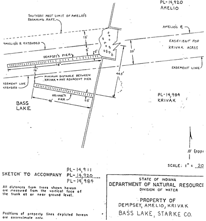
(m) A sketch included within Exhibit 4 to the Petitioner’s Response, reflecting the locations of piers under Permits PL-14,911, PL-14,920 and PL-14,984, reveals an eight (8) foot area between the Dempsey pier and the southern boundary of Amelio’s riparian zone. The sketch reveals a 16 foot area between the Dempsey pier and the Krivak pier, marked as the “minimum distance between Krivak & any adjacent pier”. The Dempsey pier is marked as 75 feet in length and 3 foot in width. The Krivak pier is marked as 48 feet in length and 3 feet in width. Petitioners’ Response, Ex. 4, pg. 11. For the reader’s ease, a portion of the sketch is included below:[4]
(n) At the conclusion of the presentation of evidence in Krivak, the Commission issued its final decision and the decision was indexed as “Krivak v DNR, Dempsey, Lenzen and Amelio, 6 CADDNAR 176 (1994)”[5]. Petitioners Response, Ex. 3, pg. 5.
(o) In Krivak, the Commission determined in its final order; “Where, as in this case, the onshore boundaries of the property owners are approximately parallel to one other, and nearly but not exactly perpendicular to the shoreline, the most direct and expedient manner for pier placement is at the same angle as the onshore boundaries of the neighbors.” Id.
(p) In Krivak, the Commission affirmed Permit, PL-14,984, “[t]he subject permit as given initial determination by the Department is as the same angle as the onshore boundaries of the neighbors and meets the spirit and intent of Nosek[6]. The subject permit should be affirmed as…conditioned by the Department in its initial determination.” Id.
(q) In Krivak, Permits PL-14,911 and PL-14,920 were also affirmed in the form given initial determination by the Department. Id. at pg. 4.
(r) The Commission also previously issued a determination in Robert Dempsey and Robert Lenzen v Department of Natural Resources, case number 92-342W[7]. In the Dempsey case, the Commission issued its “Final Order of the Natural Resources Commission” on January 14, 1993, adopting an Agreed Order submitted to the Commission by the parties, Robert Dempsey, Robert Lenzen and the Department. The Agreed Order revised the name of the permit holder for Permit PL-14,911 from “Robert Dempsey” to the “Participating Property Owners of Krivak Acres”. See the Petitioners’ Petition, Exhibit 1 and Petitioners’ Response, Exhibit 2.
(s) Also, in the Agreed Order presented by the parties in Dempsey, the parties agreed to replace the condition limiting the permitted pier length to 75 feet as follows: “the pier can be extended to length no greater than the maximum length allowed by statute, rule or local ordinance so long as the extended pier does not interfere with the use of the lake by others.” Id.
(t) The Rehlanders installed a temporary pier under a general license in 2018 with a length of 140 feet. See Petitioners’ Response, Ex.1, pg. 1.
(u) Easement holders installed a temporary pier in 2018 with a length of 269 feet. Additions perpendicular to the pier resulted in a total pier width of 19 feet. Petitioners’ Response, pg. 2.
(v) The placement of piers by the easement holders and the Rehlanders has resulted in a navigational hazard.
25. At one time, K. Rehlander’s parents, Joseph and Emily Krivak, owned the off-lake property currently known as Krivak Acres and an additional lot having lake frontage. See the testimony of K. Rehlander.
26. K. Rehlander inherited the frontage property from her parents and she is the current owner of the property referenced hereafter as the “Rehlander Property” on Bass Lake. A deed from the Joseph Krivak Estate to K. Rehlander was recorded in Starke County records on February 22, 2016. See the testimony of K. Rehlander and Ex. B, Doc 1.
27. The Easement Holders possess a dominant easement over 20 feet across the north end of the Rehlander Property. Lots 2 through 12 of Krivak Acres are currently owned by the following persons:
(a) Dempsey owns Lots 2 and 3 in Krivak Acres. He inherited one lot and purchased the other from his brother. See testimony of Lenzen.
(b) Templin owns Lot 4. Id.
(c) Lenzen bought Lots 5 and 6 of Krivak Acres in 1980. Id.
(d) Amelio owns Lot 9 in Krivak Acres. Amelio purchased the lot so that he could use easement rights possessed by Krivak Acres lot owners, although he does not intend to use the Krivak Acres’ pier. Amelio also has a pier from his own property that is adjacent to and north of the Rehlander Property. Id.
(e) Kaminski purchased Lots 7 and 8 in Krivak Acres in 2017. Id.
(f) Insufficient evidence was presented to determine the current ownership of lots 10, 11 and 12 of Krivak Acres. However, current ownership is not by Lenzen, Templin, Dempsey, Amelio or Kaminski.
28. During the administrative hearing held on March 12, 2020, the ALJ received testimony from the following witnesses:
(a) Gary Kent (“Kent”) is a Professional Surveyor. He obtained a Bachelor of Science degree in Land Surveying from Purdue in 1976. He became a licensed surveyor in Indiana in 1980 and Michigan in 1989. He has been employed by the Schneider Corporation since 1983. Kent has had experience with riparian rights for multiple lakes. He has also been a presenter on multiple occasions for programs that included topic that addressed easements, boundary law and riparian boundaries and rights. Kent asserted familiarity with the application of the principles addressed in Information Bulletin #56 (“IB #56”). See testimony of Kent and Exhibit A. See also See Riparian Zones within Public Freshwater Lakes and Navigable Waters, Information Bulletin #56 (Second Amendment), Indiana Register, 20100331-IR-312100175NRA (March 31, 2010).
(b) Terrance Lang (“Lang”) is also a licensed surveyor. He obtained his Bachelor of Science degree in Surveying from Purdue in 1983. He participated in surveying since he was 14 years of age with his father. He is employed by Lang, Feeney and Associates, a firm originally owned by his grandfather. The firm provides surveys and the services of soil scientists and engineers. He obtained his knowledge of riparian interests by attending seminars presented by Kent and through his involvement with disputes along lakes and rivers. His primary riparian experience resulted from the location of his residence on the St. Joe River’s lake caused by the Mishawaka Dam. Lang has reviewed IB #56. See testimony of Lang and Ex. I-2.
29. In addition, during the administrative hearing the ALJ received witness testimony from the following parties; Kim Rehlander, Ray Rehlander, Robert Lenzen and Nick Amelio.
30. Kent was engaged by the Rehlanders to prepare a boundary retracement survey, with the riparian zone identified. Kent performed chain of title research that included a review of an abstract of the Rehlander Property. Kent reviewed multiple documents, including public records and the Declaratory Judgment by the Fulton Circuit Court. He also reviewed IB #56. Kent prepared a Surveyor’s Report to identify the documents he reviewed and the relevance of the documents to his survey determinations. His Surveyor’s Report is attached to his draft survey. See testimony of Kent and Exhibits B, C and D.
31. As a part of his survey, Kent conducted a site visit of the area relevant to this proceeding. During his field work, he sought out monuments above and below the ground. Kent also observed piers in the water at the time of his site visit. His draft survey reflects his observations of the location of monuments and existing piers at the time of his site visit. See testimony of Kent and Exs. C and D.
32. Rehlander’s undisputed eastern property line boundary abuts County Road (“CR”) 210 and is 94.75 feet in length.
33. The deed for the Rehlander Property identifies the western boundary of the property as follows; “Thence north 90 feet along the meander line of said lake…” See the testimony of Kent and Exhibit B, Document #1.
34. Kent and Lang agree that a “meander line” is randomly used to locate a body of water, with later surveys being laid off using survey system points. Kent described the original purpose of the establishment of meander lines was to create a straight line for an otherwise irregular shoreline.
35. Kent determined that the meander line of the Rehlander Property represented the general location of the shoreline in the 1880s. Real property between the meander line of the Rehlander Property and the shoreline of Bass Lake represents accretion of shoreline since the 1880s. See testimony of Kent.
36. The parties do not dispute that the western property line for the Rehlander Property would be the shoreline of Bass Lake.
37. The undisputed southern property line for the Rehlander Property is represented by a straight line extending between the southeastern corner of the property at CR 210 and Bass Lake.
38. The undisputed portion of Rehlander northern property line extends from CR 210 to the northern terminus of the meander line and it is 41.55 feet in length. See Exhibit C and D.
39. No contrary evidence was presented by any party to dispute Kent’s factual determinations regarding the southern, eastern and western property line boundaries of the Rehlander Property. In addition, no party disputed the findings of Kent regarding the northern boundary of the Rehlander Property from CR 210 to the meander line.
40. The disputed portion of the Rehlander northern property line is the portion that extends from the meander line to the shoreline, the portion attributed to accretion. In order to establish the Rehlander’s northern boundary line between the meander line and the shoreline, Kent acknowledged two potential alternatives.
(a) Kent identified the first alternative as a straight out extension of the property line, similar to the southern property line boundary, from the meander line to the shoreline. Kent determined that this application would result in approximately a 78 degree angle at the point where the onshore boundary meets the shore. Under this alternative, Kent determined that the Rehlander Property would possess approximately 83.93 feet of shoreline, 11 feet less that the other alternative.
(b) Kent identified a second alternative that would result in the formation of an angle at the point where the meander line meets the northern boundary line. Kent determined that this application would result in approximately 86 degree angle, nearly perpendicular, at the point where the onshore boundary meets the shore. Under this alternative, Kent determined the Rehlander Property would possess 94.93 feet of shoreline.
41. Kent reviewed information concerning the southern property line boundary for the property owned by Amelio and discovered no additional guidance regarding the appropriate alternative.
42. Kent determined the second alternative would be more consistent with the placement of the monuments. Kent located a concrete boat ramp that would accommodate a pier perpendicular to the shore from the meander corner and he observed a notch in a seawall having a point that angled to the north. Kent observed a fence placed upon the Rehlander Property but placed no reliance on the location of the fence as a monument. See Ex. D.
43. Amelio obtained a permit from Starke County and installed a fence in 1988 or 1989 to denote the property line boundary between his property and the portion of the Rehlander Property that includes the Krivak Acres’ easement. He did not obtain a survey but used surveyor stakes he located at the site. See testimony of Amelio.
44. Kent, in his effort to establish a fair apportionment for the riparian boundary lakeward of the shoreline, applied the Third Principle of IB #56 to establish the northern boundary line for the Rehlander Property onshore boundary. See Ex. D.
45. Kent’s conclusions are reflected within his draft[8] “Rehlander Boundary Retracement and Riparian Zone Survey” survey completed on August 22, 2019. Kent’s draft survey was corrected on September 18, 2019. See Exs. C and D. A portion of Exhibit D is included below to show the relationship of current pier placement for the relevant area and the onshore meander line and the property boundary line, as proposed by Kent.
46. Kent has not yet recorded his survey because of this pending proceeding. See testimony of Kent.
47. Kent determined that the Fulton Circuit Court decision only addressed the easement from CR 210 to the meander line. Kent determined the easement extended to the shoreline because the court’s decision referenced the right of easement holders to access the water and to place a pier. Id.
48. Kent represented that a survey that includes dash lines represent “symbology” and solid lines represent what is being surveyed. Id.
49. Based on Kent’s survey conclusions, the Respondents’ pier would be beyond their easement.
50. Lang reviewed Kent’s survey and the documents cited by Kent in his Surveyor’s Report. Lang performed a site visit and observed property stakes. Lang disputes the determination by Kent regarding the Rehlander northern property line between the meander line and the shoreline. Lang determined that the more appropriate application would be for the property line to be extended in a straight line from CR 210 to the shoreline.
(a) Lang reviewed a 1907 plat for an area north of the properties at issue in this proceeding and determined that the plat referenced the property line as the road to the shoreline, not the road to the meander line. See testimony of Lang, Ex. I-3 and Ex. B, #13.
(b) Lang also reviewed a 1941 survey completed by the county surveyor for a property located south of the Rehlander Property. For that property, dotted lines represent extensions of the property lines to the lake in a straight line. Ex. I-4 and Ex. B, #16.
(c) Lang reviewed a 1974 plat of the Johanson Estate[9] that revealed the meander line. The plat revealed a northern property line that extended in a straight line to the shoreline. The plat did not include an angle at the meander line. Lang noted that dotted lines between the meander line and the shoreline indicated the property owner has rights that extend to the shoreline. Ex. I-5. See also Ex. B, #18.
[VOLUME 15, PAGE 118]
(d) Lang reviewed a 1992 line survey, identified as a “line survey”. The Territorial Survey identified the northern property line between Amelio and Rehlander as a straight line extension. Ex. I-6.
Following his review, Lang determined that all four of the documents he reviewed presented as property line extensions in a straight line to the water’s edge.
51. Lang reported that his analysis was only designed to address the Rehlanders’ northern property line, not riparian rights associated with the line.
52. However, Lang also offered that an application of the Second Principle would be appropriate to determine the northern riparian boundary line because the angle at which the northern property line meets the shoreline is not perpendicular.
53. Lang offered his position that IB #56 principle application should be equally applied to both the north and south riparian boundary lines because the lines represent different sides of the same property. See testimony of Lang. The southern boundary of the Rehlander Property, including any associated riparian boundary line is not at issue in this proceeding. This decision is not intended to offer any determination concerning the Rehlander southern boundary line.
54. The shoreline associated with the Amelio property and the Rehlander Property is a straight line. See Ex. D.
55. In 1974, K. Rehlander’s parents built a house on the Rehlander Property. Her recollection is that piers were historically placed perpendicular to the shoreline. See testimony of K. Rehlander.
56. R. Rehlander and K. Rehlander have been married for more than 30 years. R. Rehlander has observed the historical placement of piers over many years. See testimony of R. Rehlander.
57. K. Rehlander is aware that Bass Lake is a shallow lake and at the shoreline may be no more than 12 inches in depth. It is not unusual for her to walk her boat out to deeper water. She is aware that children swim near the piers. See testimony of K. Rehlander.
58. Currently, the Rehlander pier is installed seasonally under a general license. See testimony of R. Rehlander.
59. K. Rehlander has extended the Rehlander pier over time because she got a bigger boat. The Rehlander pier is currently 140 feet in length. See testimony of K. Rehlander and R. Rehlander.
60. The Easement Holders’ pier over time, has changed in length and width. See testimony of K. Rehlander and R. Rehlander.
61. In 1993-1994, two “decks” measuring two feet six inches by eight and one half feet were added that extended the Easement Holders’ pier width by eight and one half feet. See testimony of Lenzen.
62. In 2017, when Kaminski purchased his lots in Krivak Acres, he added four sections to the length of the Easement Holders’ pier. At that time, seven watercraft were commonly moored to the pier. See testimony of Lenzen.
63. In 2017, the Easement Holders’ pier was 225 feet in length. See testimony of R. Rehlander.
64. In 2019, the Easement Holders’ pier was 269 feet in length. See testimony of Lenzen.
65. Commonly, one or more boats are placed on the south side of the Easement Holders’ pier. See testimony of K. Rehlander and R. Rehlander.
66. Over the past two years, K. Rehlander has had difficulty navigating the area between the Rehlanders’ pier and the Easement Holders’ pier. See testimony of K. Rehlander.
67. The length of the pier to the south of the Rehlander Property and the length of the Easement Holders’ pier creates a corridor that results in visibility issues for the Rehlanders. See testimony of R. Rehlander.
68. R. Rehlander notified Lenzen and Templin that he perceived a navigational safety issue and offered a solution that was not accepted. In 2017, R. Rehlander called the Department and complained prior to filing this proceeding.
69. The current distance between the Rehlander pier and the Easement Holders’ pier, at the closest point, is eight and one half feet. See testimony of R. Rehlander.
70. Aerial photographs of the relevant area reveal the majority of the piers in the vicinity are placed in a manner that appear nearly parallel to one another, with the exception of the Rehlander pier. Ex. E and F.
71. No Krivak Acres’ lot owner has requested Rehlander’s permission to place a pier. See testimony of Lenzen.
Conclusions of Law
Riparian ownership and use
72. The Indiana Court of Appeals has acknowledged the jurisdiction of the Commission to determine the scope of a landward property right, including an easement, “to the extent necessary to carry out the process of issuing permits for the placement of piers on public freshwater lakes.” Kranz v Meyers Subdivision, et al, 969 N.E.2d 1068, 1078 (Ind. App. 2012).
73. It is the practice of the Commission to exercise that authority with restraint. Bowman v Walls, 14 CADDNAR 85, 89 (2016).
74. “Accretion is the process of gradual and imperceptible increase in land caused by the deposit of earth, sand or sediment thereon by contiguous waters and is held to be a source of title. Irvin v. Crammond, 108 N.E. 539 (Ind. App. 1915), as cited in Longabaugh v. Johnson, 321 N.E. 2d 865, 867 (Ind. App. 1975).
- “Accretion rights in public freshwater lakes are limited to land from which the waters have receded or may recede from natural causes only.” IC 14-26-2-8.
- “‘The question is well settled at common law that the person whose land is bounded by a stream of water, which changes its course gradually by alluvial formations, shall still hold the same boundary, including the accumulated soil. No other rule can be applied on just principles.’” Town of Freedom v. Norris, 27 N.E. 869, 870 (Ind. 1891) citing New Orleans v. U.S., 10 PET. 660. See also, Longabaugh v. Johnson, 321 N.E.2d 865 (Ind. App. 1975) and Parkison v. McCue, 831 N.E.2d 118 (Ind. App. 2005)[10].
- The metes and bounds description of the Rehlander Property identifies the meander line of Bass Lake but does not reference the current shoreline of Bass Lake.
- Kent reasonably concluded that accretion has occurred since the time when the meander line was first identified in a deed.
79. There is no evidence that the land lying between the northern boundary of the Rehlander Property, as stated in the legal description, resulted from drainage of Bass Lake, or other non-natural occurrence.
80. Taking the evidence presented in this proceeding as a whole, it is reasonable to conclude that the land area existing between the Rehlander Property’s western boundary, as stated in the legal description, and the actual shoreline of Bass Lake is natural accretion to which Rehlander is entitled to benefit.
81. The Rehlander Property line, adjacent to Amelio, extends to the shoreline of Bass Lake.
82. The northern property line boundary between Rehlander and Amelio from the meander line to the shoreline of Bass Lake by virtue of accretion is disputed.
- Kent proposed to determine the property boundary line using the principles described in IB #56 in an effort to establish a fair apportionment for the riparian boundary lakeward of the shoreline. Kent’s application of IB #56 is misplaced. The Commission has adopted a nonrule policy document under IC 4-22-7-7 to aid in determinations concerning riparian zones and the placement of structures within public freshwater lakes. IB #56. IB #56 is limited in its application and is not designed for appropriate delineation of onshore property boundary lines.
84. The proposed property line boundary proposed by Kent is unsupported by the weight of the evidence. The appropriate northern boundary line attributable to accretion extends in a straight line from CR 210 to the shoreline of Bass Lake.
85. Through accretion, the western shoreline of the Rehlander Property was extended, having the corresponding effect of the extension of the property boundary lines to the shoreline. The western boundary of the Rehlander Property extends from CR 210 beyond the meander line to its terminus at the Bass Lake shoreline.
86. While no deed was produced for the property of Amelio, the research conducted by Kent and his review of the deed for the Amelio property supports a conclusion that Amelio’s property also extends to the shoreline.
- The Commission has adopted a rule defining a “riparian owner” to mean “…the owner of land…bound by a lake….” 312 IAC 11-2-19.
88. Amelio and Rehlander are riparian owners.
89. Dempsey[11], Lenzen, Templin and Kaminski are the owners of off-lake lots within Krivak Acres and are not riparian owners.
90. The Fulton Circuit Court previously determined that the Rehlander Property is a servient estate over which a dominant easement is held by the owners of Lots 2-12 of Krivak Acres (“Krivak Acres”). The Krivak Acres’ easement is located within the northern 20 feet of the Rehlander Property between the meander line and the eastern property line of the Rehlander property. In this case, the dominant easement holders are also entitled to benefit from the natural accretion of the actual shoreline of Bass Lake, in the same manner as the servient estate.
Riparian Boundary Line between Amelio and Rehlander
- A riparian owner typically enjoys rights that include: “(1) access to navigable water; (2) the right to build a pier out to the line of navigability; (3) the right to accretions; and (4) the right to a reasonable use of the water for general purposes such as boating, domestic use, etc.” Parkison v McCue, supra at 128.
- Petitioners assert that a pier placed by the Respondents “infringes upon our riparian rights.” See the Petition.
- In order to determine whether any temporary structure infringes or encroaches on the Rehlander riparian boundary zone, the common riparian boundary between Amelio and Rehlander must be determined.
- The Lakes Preservation Act authorizes the Commission to resolve disputes among persons with competing interests. IC 14-26-2-23(e)(3)(B).
- Nonrule policies, such as IB #56, adopted by the Commission do not have the effect of law. Information bulletins are intended to be statements that interpret, supplement or implement a statute. Nonrule policies published in the Indiana Register are readily available through the Commission’s website and are frequently used by the Commission as guidance documents.
- IB #56 is widely followed to provide guidance and principles for determining riparian boundaries. The overarching objective of the guidance document is that the “principles seek to accommodate the diverse characteristics of Indiana’s numerous public freshwater lakes. They are designed to provide riparian owners with equitable access to public waters….” IB #56, pg. 3.
97. The shoreline at issue in this proceeding represents as a straight line.
98. IB #56, as its “Second Principle”, states, “Where the shore approximates a straight line, and where the onshore property boundaries are approximately perpendicular to this line, the boundaries of riparian zones are determined by extending the onshore boundaries into the public waters. Bath v. Courts, 459 N.E.2d 72, 73 (Ind. App. 1984), and IB #56, pg. 3.
99. IB #56, as its “Third Principle”, states, “Where the shore approximates a straight line, and where the onshore boundaries approach the shore at obtuse or acute angles, the boundaries of riparian zones are generally determined by extending a straight line at a perpendicular to the shore. If the boundaries of two owners intersect at the shore, or in proximity to but landward of the shore, the boundaries of the riparian zones may be formed by a perpendicular to the shore from the point of intersection of the onshore boundaries. Lukis v. Ray, 888 N.E.2d 325 (Ind. App. 2008), citing Nosek v. Stryker, 103 Wis.2d 633, 309 N.W.2d 868 (Wis. 1981) and IB #56, pg. 4.
100. Application of the Third Principle is most compelling where land owners in the vicinity have historically used a perpendicular line to divide their riparian zones, but the principle should not be applied where a result is to deprive a riparian owner of reasonable access to public waters. Pipp v. Spitler, et al., 11 CADDNAR 39 (2007) and IB #56, pg. 4.
101. Historically, the Rehlander pier has been placed perpendicular to the shoreline. However, piers placed on either side of the Rehlander pier appear to have been placed to reflect a straight out extension of the onshore boundary lines.
102. The Indiana Court of Appeals has acknowledged the need to carefully review the facts and circumstances of each case and that the standards are “fluid and best applied on a case-by-case basis.” Lukis v Ray, 888 N.E. 2d 325, 332 (Ind App. 2008). The Lukis Court observed:
…the NRC acknowledged the wisdom of the Nosek[12] rule, merely concluding that the extension of boundary lines would accomplish an equally fair result. The NRC acknowledged that the shoreline ‘is generally irregular and the parties' onshore property lines are not perpendicular to the shoreline’ and found that a ‘complete reliance’ on the extension of boundary lines lakeward was “misplaced.’… The NRC then concluded, however, that, ‘in this particular case, the result of establishing the parties' riparian zones by extending onshore property lines lakeward, equivocates the apportionment of riparian zones consistent with the amount of shoreline owned by each respective owner.’…. Having carefully reviewed the facts and circumstances of the case, the NRC concluded that extending the property lines lakeward was equitable and resulted in a fair apportionment. That there may have been other results that would, likewise, have been equitable does not mean that the NRC arrived at a result that was erroneous or contrary to law.
Id at 332, emphasis in the original.
103. The Commission considered permits issued by the Department for the owners of properties at issue in this case in Krivak, supra. The Commission, in that case, for the purpose of individual pier permit review, found that “the onshore boundaries of the property owners approach the shoreline at other than a perpendicular” The Commission determined that “Where, as in this case, the onshore boundaries of the property owners are approximately parallel to one another, and nearly but not exactly perpendicular to the shoreline, the most direct and expedient manner for pier placement is at the same angle as the onshore boundaries of the neighbors”. Id. at 177. See also Exhibit I-1.
104. The issues determined by the Commission in Krivak were limited to review of individual pier permits. However, the conclusions of the Commission in that case are determined to present a reasonable application of facts that are also relevant to this proceeding regarding the same properties.
105. The appropriate application of IB #56 in this proceeding results in the determination of the riparian boundary between Amelio and Rehlander by extending onshore boundary lines into the public waters in a straight line.
106. This decision is not intended to address the Rehlander southern property line boundary in any manner.
Easement Holder Riparian Use Rights
107. The conclusion that Dempsey, Lenzen, Templin and Kaminski are not riparian owners is not determinative of their right to exercise riparian rights arising out of an easement.
108. It is well established that easements are limited to the purpose for which they are granted. The owner of an easement, known as the dominant estate, possesses all rights necessarily incident to the enjoyment of the easement. The owner of the property over which the easement passes, known as the servient estate, may use his property in any manner and for any purpose consistent with the enjoyment of the easement, and the dominant estate cannot interfere with the use. All rights necessarily incident to the enjoyment of the easement are possessed by the owner of the dominant estate, and it is the duty of the servient owner to permit the dominant owner to enjoy his easement without interference. The servient owner may not so use his land as to obstruct the easement or interfere with the enjoyment thereof by the owner of the dominant estate. Xanders v. Nixon Trust, 14 CADDNAR 33, 40 (2015) citing, Rehl v. Billetz, 963 N.E.2d 1 (Ind. App. 2012).
109. The Fulton Circuit Court, in case number 25C01-9105-CP-0178, as a court of competent jurisdiction, issued a Declaratory Judgment regarding easement rights and the right to place a pier by certain Krivak Acres property owners.
110. In determining the extent of easement ownership, the Fulton Circuit Court did not determine specific pier placement, length, width or any specific configuration for the easement holders’ pier within the riparian zone available to the easement holders through ownership of the dominant estate.
111. The Declaratory Judgment established the Easement Holders’ dominant estate over the northern 20 feet of Krivaks’ property, now the Rehlander Property. The Krivak property is burdened as the servient estate for the easement. The easement was determined to provide a way of access to Bass Lake and the authority to place and maintain a pier. The right requires the selection of pier placement that allows for reasonable use of the lake by others.
112. In that the Fulton County Court determined that the rights run with the land, the determination by the Court is binding on current owners of the properties that form the dominant and servient estates.
113. The rights of the Easement Holders, as determined by the Fulton Circuit Court, are not in question. Rehlander is the current owner of the servient estate while the owners of Krivak Acres Lots 2 through 12 are the holders of the dominant estate.
114. The Easement Holders’ dominant estate over the northern 20 feet of the Rehlander Property extends in a similar manner into Bass Lake to provide riparian use rights over the northern 20 feet of the Rehlanders’ riparian zone.
115. The easement would include no rights north of the riparian boundary line between Amelio and Rehlander.
116. The easement would also not extend beyond 20 feet south of the Rehlanders’ northern riparian boundary line for any purpose related to the easement.
117. After the determination by the Fulton Circuit Court, an individual permit was obtained by Dempsey. In Krivak, the Commission upheld the form of the pier within the approved permit. The Dempsey permit was subsequently modified in an unindexed decision to reflect a change in the permit holder from “Dempsey” to the “Participating Property Owners of Krivak Acres.” Dempsey, supra.
118. Seasonal removal of an individual license for a temporary structure completed timely does not terminate a license if the temporary structure conforms to the terms of the license when the structure s replaced. 312 IAC 11-3.5-2.
119. In this case, the configuration for the pier permitted to Dempsey and then to the Participating Property Owners of Krivak Acres has been modified over time in both length and width. The temporary structure no longer conforms to the original approved permit or the modification and has been abandoned. The individual permit is no longer valid.[13]
120. The Easement Holders’ pier must be analyzed to determine if it qualifies under a general license.
121. A group pier does not qualify for a general license. A group pier requires a written individual license. 312 IAC 11-3-1(b) and 312 IAC 11-3-3(f)(2).
122. A group pier is defined as a “pier that provides docking space for any of the following” (1) At least five (5) separate property owners...(5) A subdivision or an addition. 312 IAC 11-2-11.5.
123. The Fulton Circuit Court determined the easement is owned by the owners of Lots 2 through 12 of Krivak Acres. Lot owners of Lots 2 through 12 total at least five owners, including Lenzen, Templin, Dempsey, Amelio, Kaminski and one or more owners of Lots 10, 11 and 12.
124. Any pier placed on behalf of the Easement Holders presents as a pier with rights available to all Easement Holders. An Easement Holder pier must not restrict assess or use by any single Easement Holder or any combination of Easement Holders fewer than the total of the lot owners possessing the easement.
[VOLUME 15, PAGE 120]
125. The owners of Lots 2 through 12 of Krivak Acres include at least five owners who possess the authority to place a pier. In addition, while evidence was not presented on this point, it is a likely conclusion that Krivak Acres may be a subdivision or addition that would also require a group pier permit. Therefore, the Easement Holders must obtain a group pier permit in order to place a pier.
Safe Navigation-Clear Space
126. Any pier placed by the Easement Holders pursuant to its dominant easement must be placed in a way that would allow for reasonable usage of the lake by all users.
127. Consideration for navigational safety is critical in this regard. Current placement of piers by the parties in this case creates a navigational safety concern.
128. IB #56 states, “To assist with safe navigation, as well as to preserve the public trust and the rights of neighboring riparian owners, there ideally should be 10 feet of clearance on both sides (for a total of 20 feet) of the dividing line between riparian zones. At a minimum, a total of 10 feet is typically required that is clear of piers and moored boats, although the area may be used for loading and unloading boats and for active recreation.” See IB #56, pg. 2.
129. The Commission has routinely concluded that a buffer or clear space between piers and moored boats is necessary to provide for safe navigation. IB #56, Roberts v BeachviewProperties, LLC, et al., 10 CADDNAR 125, 166 (2005), Sims, et al. v Outlook Cove, LLC and Outlook Cove Homeowners Ass’n, 10 CADDNAR 258. 279, (2006), Havel & Stickelmeyer v Fisher, et al., 11 CADDNAR 110, 119 (2007), Rufenbarger & Rufenbarger v. Blue, et al., 11 CADDNAR 185 (2007), and Xanders v Nixon Trust, 14 CADDNAR 33 (2015).
130. IB #56 recommends that a total of 20 feet of clear space and minimally 10 feet of clear space is customary. Ideally, each riparian owner would bear the responsibility to contribute one half of the total required buffer. However, the Commission recognizes the limitations of area available to some lake users.
131. Previously, the Commission approved permits for the area included within these riparian zones. In Krivak, the Commission determined that a distance of 20 feet was necessary between the Dempsey pier and Amelio’s swimming raft. The pier placement condition previously identified and approved in form by the Commission has not created a navigational concern between the Easement Holders and Amelio.
132. In Krivak, the Commission determined that a distance of 16 feet was necessary between Krivak’s pier, now the Rehlander Property pier, and any adjacent pier. The distance between piers that was previously designated has not served to preserve navigational safety
133. The decision in Krivak did not consider necessary “clear space” that would not constrict open water, clear of piers and moored boats that may be used only for loading and unloading boats and for active recreation.
134. In recognition of the limited space available to the Easement Holders, on the northern side of the riparian boundary line between Amelio and the Rehlander Property, ten feet of clear space is required to preserve navigational safety. On the southern side of the riparian boundary line between Amelio and the Rehlander Property, two feet of clear space is required.
135. On either side of the Easement Holders’ southern riparian easement boundary, located 20 feet south of the Amelio and Rehlander riparian boundary line, a clear space is required. Seven feet of clear space is required north of the line and seven feet of clear space required south of the line.
136. Riparian owners may build a pier within the extension of their onshore boundaries only so far out as not to interfere with the use of the lake by others. Bath v Courts, 459 N.E.2d 72, 76 (Ind. App. 1984).
137. Limitations to the authority of a riparian owner in placing a temporary structure include the limitation that the structure may not “infringe on the access of an adjacent landowner to the public freshwater lake.” 312 IAC 11-3-1(b)(2) and 312 IAC 5-6-3.
138. The resolution of a riparian dispute is also subject to the “reasonableness” test:
…Instead of a rigid application using a measure of depth or length to determine riparian boundaries, the better view would be to apply a “reasonableness” test to accommodate the diverse characteristics of Indiana’s numerous freshwater lakes.” The reasonableness determination “should be decided on the basis of the facts and circumstances of each particular case so that a court can treat each affected riparian owner equitably.” Lukis v. Ray, 888 N.E.2d 325, 332 (Ind. App. 2008) citing Zapffe v. Srbeny, 587 N.E.2d 177, 181 (Ind. App. 1992).
139. Citing Zapffe v. Srbeny, the Commission underlined applicability of the reasonableness test in IB #56:
A “reasonableness” test is applied to how far a pier may extend from the shore. The installation of a pier by a riparian owner is unreasonable if the pier interferes with the use of a public freshwater lake by others. “One point is well-settled...the boundaries of riparian property do not extend to the middle of the lake….” Any extension of a pier beyond the point required for the mooring and launching of boats may be considered unreasonable.
IB at 2.
140. A reasonable length for the Easement Holders’ pier must be considered in obtaining a group pier permit. 312 IAC 11-4-8.
Final Order
1) The onshore property line of Rehlander extends from CR 210 to Bass Lake in a straight line from the northeastern most point, through the northern terminus of the meander line identified in the deed for the property, to the shoreline of Bass Lake.
2) The common riparian zone boundary line between Rehlander and Amelio shall be determined by an extension of the onshore property boundary line into the waters of Bass Lake extended in a straight line. The northern 20 feet of the Rehlander riparian zone is subject to riparian rights of the Easement Holders.
3) The Easement Holders must not place a pier without obtaining group pier permit approval from the Department of Natural Resources. The permit may include conditions as deemed necessary by the Department but must include the restrictions ordered herein.
4) No portion of a temporary structure, including watercraft moored to the temporary structure, may be maintained within a zone designated herein as a “clear space” within which constriction of open water is prohibited. The clear space must be clear of piers, pier extensions and moored boats and may be used only for loading and unloading boats and for active recreation.
5) Clear space is required ten (10) feet north and two (2) feet south of the riparian boundary line between Amelio and Rehlander.
6) Clear space is required seven (7) feet north and seven (7) feet south of the Easement Holders’ southern riparian boundary.