CADDNAR
[CITE: Kiefer v. Diller, 15 CADDNAR 67 (2019)]
[VOLUME 15, PAGE 67]
Cause #: 18-032W
Caption: Kiefer v. Diller
Administrative Law Judge: Jensen
Attorneys: Keifer (Keifer); Dillar (pro se)
Date: April 18, 2019
[Editor’s Note: Final Order follows Findings of Fact and Conclusions of Law.]
FINDINGS OF FACT AND CONCLUSIONS OF LAW WITH FINAL ORDER ON PETITIONER’S MOTION FOR SUMMARY JUDGMENT
Procedural Background and Jurisdiction
1. For consideration by the Natural Resources Commission (Commission) is a “Petition for Administrative Review” (Petition), filed by Petitioner, Cynthia K. Kiefer (Kiefer), on March 17, 2018 alleging that Respondents, Kelvin Diller and Jewel Diller (collectively referred to as “the Dillers”) unlawfully placed a pier and moored a boat within the waters of Blue Lake in a manner that interferes with her exercise of riparian rights.
2. Within her Petition, Kiefer maintains that she is the owner of real property described as Lot 5 of the Lucretia A. McGuire’s First Addition to Blue Lake Resort Subdivision (Subdivision I) that “shares a boundary with Blue Lake, a public freshwater lake…” and is bordered on one side by “a ten foot (10’) unplatted tract that lies between Lots 5 & 6.”
3. The Petition identifies Respondents, Kelvin Diller and Jewel Diller, as the owners of Lot 47 of the Lucretia A. McGuire’s Second Addition to Blue Lake Resort Subdivision (Subdivision II), which does not share a boundary with Blue Lake.
4. The Commission possesses authority to determine the dispute presented by the Petitioner under Indiana Code § 14-26-2-23(e)(3) and 312 IAC 11-1-3 et seq.
5. Administrative review in the context of this proceeding is controlled by Indiana Code §§ 4-21.5-3 and 312 IAC 3.
6. The Commission serves as the “ultimate authority” with respect to this proceeding. Indiana Code §§ 4-21.5-1-15 and 14-10-2-3.
7. The Commission possesses jurisdiction over the subject matter of this proceeding and of the persons of the parties.
8. Administrative Law Judge (ALJ) Jensen was appointed in accordance with Indiana Code § 14-10-2-2.
9. ALJ Jensen conducted a Prehearing Conference on April 18, 2018 at which time Kiefer was represented by Counsel, Troy C. Kiefer, and the Dillers were represented by Counsel, Matthew R. Shipman.
10. On August 22, 2018, Mr. Shipman was permitted to withdraw as Counsel for the Dillers and since that time the Dillers have been self-represented.
11. A Status Conference was conducted on September 12, 2018, at which time a summary judgment briefing schedule was established.
12. Kiefer timely filed her motion for summary judgment, along with a supporting memorandum and designation of evidence to which the Dillers filed no response.
13. An “Interlocutory Order on Petitioner’s Motion for Summary Judgment” (Summary Judgment Order) was issued on December 17, 2018 in which, at Findings 48 through 50, the following material facts were determined to be established:
48. Kiefer owns real property described as Lot 5 in Lucretia A. McGuire’s First Addition to Blue Lake Resort.
49. The Dillers own real property described as Lot 47 of Lucretia A. McGuire’s Second Addition to Blue Lake Resort.
50. The Dillers extended a pier into Blue Lake from a ten (10) foot strip of land situated between the Kiefer Property and Lot 6 of the First Addition, without obtaining a permit.
14. The Summary Judgment Order stated that “all aspects of this proceeding pertaining to the parties’ possession and exercise of riparian rights remains in controversy.”
15. On January 9, 2019, Kiefer, by counsel, filed “Petitioner’s Petition to Reconsider” along with “Petitioner’s Amended Designation of Evidence and Table of Contents in Support of Motion to Reconsider” (Summary Judgment Motion II)
16. Kiefer’s Petition to Reconsider was granted on January 14, 2019 and the Dillers were provided until February 13, 2019 to file a Response.
17. Documents contained within the record reflect that the Dillers attempted, without success, to file a Response on February 12, 2019 by email but the email address was typed incorrectly and the Response was not received by the Commission. The February 12, 2019 email indicates that copies of the Response were directed to non-party representatives of the Department of Natural Resources but no copy was directed to Kiefer’s counsel.
18. The Dillers attempted to resend the Response on February 14, 2019, and ultimately the Response was received at the Commission on February 18, 2019. At no time, did the Dillers serve Kiefer with a copy of their Response. See “Affidavit Regarding Receipt of Service” filed February 21, 2019.
19. Because the Dillers’ Response was not served upon the opposing party in accordance with Indiana Code § 4-21.5-3-1(e), the Response is not properly considered.
Summary Judgment Standard
20. Under AOPA, summary judgment is to be considered in the same manner as a court would consider summary judgment under Trial Rule 56 of the Indiana Rules of Trial Procedure. Indiana Code § 4-21.5-3-23.
21. A party may move for summary judgment at any time after an Administrative Proceeding has been assigned to an ALJ. Id.
22. Summary judgment “shall be rendered forthwith if the designated evidentiary matter shows that there is no genuine issue as to any material fact and that the moving party is entitled to a judgment as a matter of law.” Trial Rule 56(C).
23. “The purpose of summary judgment is to terminate litigation about which there can be no factual dispute and which may be determined as a matter of law.” Orem v. Ivy Tech State College, 711 N.E.2d 864, (Ind. App. 1999).
24. “Summary judgment is appropriate only when the designated evidence shows there is no genuine issue of material fact and the moving party is entitled to judgment as a matter of law.” Trial Rule 56(C), Erie Indemnity Company for Subscribers at Erie Insurance Exchange v. Estate of Harris by Harris, 99 N.E.3d 625 (2018).
25. “Summary judgment shall not be granted as of course because the opposing party fails to offer opposing affidavits or evidence, but the court shall make its determination from the evidentiary matter designated to the court.” Trial Rule 56(C).
Findings of Fact[1]
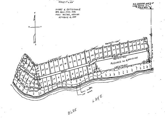
26. Subdivision I, which contains 13, 45 foot by 100 foot lots, was established in 1937. The lots in Subdivision I, as platted in 1937, do not share a boundary with Blue Lake. Exhibit H.
[VOLUME 15, PAGE 68]
27. For purposes of this order the lots in Subdivision I will be described as “lake view” lots.
28. McGuires Road is located generally to the north and Blue Lake is located generally to the south of the Subdivision I lake view lots. Exhibit J.
29. Kiefer became the owner of Lot 5 in Subdivision I in 2016. Exhibit I
30. On July 14, 2017 Kiefer filed a “Complaint” in the Whitley Circuit Court to establish adverse possession of and quiet title to the land situated between the southern boundary of Lot 5 and the shoreline of Blue Lake. Exhibit J. An “Order on Default and Entry of Judgment” was entered on January 24, 2018, which established Kiefer as the owner, by adverse possession, of the land lying between Lot 5’s southern boundary and the shoreline of Blue Lake. Exhibit K. Through this action, Kiefer became the owner of land immediately adjacent to and adjoining the shoreline of Blue Lake.
31. At four locations, the plat of Subdivision I identifies a 10 foot wide “walk” running in a generally north-south direction from McGuires Road to the shoreline of Blue Lake. These walks are located in between certain Subdivision I lake view lots. Exhibit H.
32. The only platted walk at issue in this proceeding is the one located between the western boundary line of Kiefer’s Lot 5 and the eastern boundary line of Lot 6 in Subdivision I. For purposes of this order, this walk shall be referred to as “the Walk”.
33. Subdivision II, which was divided into 49 lots, walkways, and road as depicted on the plat, was established in 1938. Exhibit M. Lots numbered 1 through 19 of Subdivision II are situated consistent with the curvature of the shoreline of Blue Lake with lot 1 located immediately west of Subdivision I with sequentially increasing lot numbers extending further westward. Lots 1 through 19 of Subdivision II are not located adjacent to the shoreline of Blue Lake and will also be referred to as lake view lots. Id.
34. Lots numbered 1 through 19 in Subdivision II are located on the south side of and adjacent to McGuires Road in the same manner in which the Lots 1 through 13 of Subdivision I are located. Id.
35. Lots numbered 20 through 49 of Subdivision II are situated adjacent to and north of McGuire Road. Exhibit M. These lots are separated from Blue Lake by McGuires Road and by the lake view lots of Subdivision I and Subdivision II and do not share a boundary with the shore of Blue Lake. Id.
36. The Dillers are the owners of Lot 47 in Subdivision II. Exhibits L.
The diagram below, taken from Exhibit M, depicts the plat of Subdivision II and the location of Subdivision I, without platting, is provided for illustrative purposes only.
37. Neither the Dillers’ Special Warranty Deed, nor Kiefer’s Warranty Deed, contain language conveying to them any interest in the 10 foot walk located to the west of Kiefer’s Lot 5 or the shoreline of Blue Lake by fee title ownership or by easement.
38. Evidence of Lucretia A. McGuire’s (McGuire) intent with respect to the platting of walks within Subdivision I is found in the original deed of what is now Kiefer’s Lot 5 in Subdivision I, which McGuire conveyed to Allen E. and Ida Mae Oldfather (the Oldfathers) on May 18, 1939. That deed states that “[Oldfathers] shall have access to the waters of Blue Lake over the lands of [McGuire] lying between said lot line and said Lake.” Exhibit C. Evidence that McGuire intended lots within Subdivision II to enjoy the same rights to the walks is evidenced in the original deed of Lot 44[2] in Subdivision II conveyed by McGuire to Herman Gerding on May 24, 1940 that contains the exact same language. Exhibit O.
39. It is reasonably concluded that Kiefer, the Dillers and likely every lot owner within Subdivision I and Subdivision II share the same rights to use the Walk.
40. The evidence provides little detail regarding the configuration of the piers placed and maintained by either Kiefer or the Dillers except that the Dillers extended a pier into Blue Lake from the Walk with the shore end of the pier being located within six (6) feet of Kiefer’s western property boundary line and “directly on my riparian rights line[3] on the lakeward end.” Exhibit A. Kiefer maintains that the Dillers placement and maintenance of a pier at this location interferes with her use of the western side of her pier. Id.
41. Kiefer placed into evidence the “Report of Telephone Status Conference” dated May 29, 2018, wherein a discussion is recounted by which the Dillers, at that time by counsel, alleged that Kiefer’s mooring of watercraft boat to one side of her pier would cause the watercraft to be located within the waters lakeward of the Walk, which was previously noted to be located to the west of the western boundary of Kiefer’s Lot 5.
Conclusions of Law
42. The evaluation of the facts established in this proceeding is significantly similar to the discussion contained within two recent decisions of the Commission in Hodges v. Lampkin & Miller, 15 CADDNAR 1 (2018) and Dennis v. Sutton and Melendez, 14 CADDNAR 148 (2017).
43. In accordance with Indiana Code § 14-26-2-23(e)(3), the Commission “[established] a process under IC 4-21.5 for the mediation of disputes among persons with competing interests” relating to the exercise of riparian rights on Indiana’s public freshwater lakes. 312 IAC 11-3-1.
44. Kiefer initiated the instant proceeding under 312 IAC 11-3-1 seeking resolution of the riparian rights dispute between her and the Dillers.
45. Pursuant to 312 IAC 11-2-19, a “riparian owner” is an “owner of land, or the owner of an interest in land sufficient to establish the same legal standing as the owner of land, bound by a lake.”
46. Kiefer is a riparian owner by virtue of her ownership of the land lying adjacent to Blue Lake within the lateral limits of Lot 5 of Subdivision I.
47. A temporary structure is defined as “a structure that can be installed and removed from the waters of a public freshwater lake without using a crane, bulldozer, backhoe, or similar heavy or large machinery.” A pier of a type that is placed into and removed from the water on a seasonal basis typically qualifies as a temporary structure. 312 IAC 11-2-25.
48. A person may place and maintain a temporary structure lakeward of the shoreline of a public freshwater lake under a general license if the temporary structure meets specified qualifying characteristics. 312 IAC 11-3-1. To qualify for placement and maintenance without the need for a written license the temporary structure must:
(1) Be easily removable.
(2) Not infringe on the access of an adjacent landowner to the public freshwater lake.
(3) Not unduly restrict navigation.
(4) Not be unusually wide or long relative to similar structures within the vicinity on the same public freshwater lake.
(5) Not extend more than one hundred fifty (150) feet from the shoreline or water line.
(6) If a pier, not extend over water that is continuously more than six (6) feet deep to a distance of one hundred fifty (150) feet from the shoreline or water line.
(7) Not be a marina.
(8) Not be a group pier.
(9) Be placed by a riparian owner or with the written approval of a riparian owner.
312 IAC 11-3-1(b)(1-9).
49. Along the width of the shore of Blue Lake within the lateral limits of Lot 5, Kiefer may exercise riparian rights including the placement and maintenance of a temporary structure meeting the characteristics described in 312 IAC 11-3-1(b)(1-8).
50. The allegations of Kiefer raise issues relating to 312 IAC 11-3-1(b)(2) and (9) in that she alleges the Dillers’ pier infringes upon her access to Blue Lake and because she maintains that the Dillers are not riparian owners or persons acting with the written approval of a riparian owner.
51. Because the determination of riparian ownership is necessarily connected to ownership or other interest in real property, such a determination obligates the Commission to determine the legal rights of persons in real property. “The Commission possesses ‘authority to determine landward property rights ‘to the extent necessary to carry out’ its statutory obligation to resolve disputes between competing riparian owners.’” Hodges, supra, citing Dennis v. Sutton and Melendez, 14 CADDNAR 148 (2017), citing Bowman v. Walls, 14 CADDNAR 85 (2016) citing Kranz v. Meyers Subdivision Prop. Owners Ass’n, 969 N.E.2d 1068 (Ind. Ct. App., 2012).
52. The Dillers are not riparian owners by virtue of their ownership of Lot 47 in Subdivision II.
53. There is no evidence that the Dillers purport to be acting upon the written authority of another riparian owner with respect to their extension of a pier from the shore of the Walk.
54. The remaining consideration is whether the Dillers possess an interest in the Walk “sufficient to establish the same legal standing as the owner of land, bound by a lake” in order to qualify as a “riparian owner”.
55. McGuire expressly stated in deeds to Lots in Subdivision I and Subdivision II that the Walk was intended to provide the owners “access to the water…” Such expression being construed as an intent to dedicate the Walk to those lot owners[4] is consistent with past determinations of the Commission as well as decisions of the Indiana Courts. See Tersigni v. Osbon and Wright, 13 CADDNAR 60 (2012), Dennis v. Sutton & Melendez, 14 CADDNAR 148, 151 (2017) McAllister v. Sanders, 937 N.E.2d 378 (Ind. Ct. App., 2010) and Chaja v. Smith, 755 N.E.2d 611 (Ind. Ct. App. 2001); also Bass v. Salyer, 923 N.E.2d 961 (Ind. Ct. App. 2010), and Brown v. Heidersbach, 360 N.E.2d 614 (1977).
56. No evidence exists in the record to support a conclusion that the Dillers possess any greater interest in the Walk than the interest enjoyed by any other lot owner in Subdivision I or Subdivision II, including Kiefer. Conversely, Kiefer’s interest in the Walk is no greater than that possessed by the Dillers or any other owner of a lot in Subdivision I or Subdivision II.
57. Effectively, the Dillers and Kiefer possess non-exclusive easement rights in the Walk that are shared with other lot owners in Subdivision I and Subdivision II.
58. It is not within the jurisdiction of the Commission to determine the full extent of the use that may be made of the Walk but the evidence is sufficient and the jurisdiction of the Commission is proper to determine whether the Dillers possess sufficient authority to extend a temporary pier from the shoreline of the Walk.
59. An “owner in common of an easement may not alter or use the land in such a manner as to render the easement appreciably less convenient and useful for other co-owners.” Hodges, supra, citing Parkison v. McCue, 831 N.E.2d 118, 132 (Ind. Ct. App. 2005). With the Walk’s lateral limitation of 10 feet, the use of the shoreline attributed to the Walk by the Dillers for the placement and maintenance of a temporary pier for their exclusive use effectively prohibits every other co-owner of the easement from making any use of that shoreline area. Such an outcome is not consistent with the appropriate use of a non-exclusive easement. Dennis, supra.
60. Similarly, Kiefer possesses no greater rights to the shoreline of Blue Lake associated with the Walk than do the Dillers or other lot owner within Subdivision I or Subdivision II. Just as the Dillers may not interfere with the use made by other co-owners of the easement by placing and maintaining a pier, Kiefer may also not exercise her riparian rights within the lateral limits of Lot 5 in such a manner as to interfere with those rights.
61. “When a boat is moored to a pier, the consequences of the usage are similar to those of the pier, and the boat essentially becomes an extension of the pier. Mooring a boat is an exercise of proprietary rights and would typically be unreasonable in the same locations where a pier would be unreasonable.” Barbee Villa Condominium Owners Assoc. v. Shrock, 10 CADDNAR 23, 26 (2005).
[VOLUME 15, PAGE 69]
62. To the extent Kiefer’s pier is situated within the lateral limits of Lot 5 in such a manner that the mooring of watercraft on the west side of that pier places the watercraft within the waters lakeward of the Walk, such is not permitted. Dennis, supra.
63. Because determination of the issues related to 312 IAC 11-3-1(b)(9) are dispositive of this proceeding, the issues raised by Petitioner relating to 312 IAC 11-3-1(b)(2) are not considered further.
Final Order
64. The Dillers are permanently enjoined from placing a pier, mooring watercraft or maintaining other temporary structures from the shoreline of or within the waters of Blue Lake within the 1ateral limits of the Walk.
65. Kiefer is also permanently enjoined from placing a pier, mooring watercraft or maintaining other temporary structures from the shoreline of or with within the waters of Blue Lake within the lateral limits of the Walk.
[1] A Finding of Fact more appropriately construed as a Conclusion of Law or a Conclusion of Law more appropriately considered a Finding of Fact shall so be considered.
[2] Within “Petitioner’s Motion to Reconsider” the deed to Lot 44 is described as the deed to Lot 47 that is now owned by the Dillers. Although, the evidence of record does not provide a historic deed for Lot 47, the deeds provided offer evidence of the intended purpose for the walks. It is presumed that the historical deed for Lot 47 contains this same language.
[3] There is no evidence in the record from which to ascertain how Kiefer identified the location of her “riparian rights line on the lakeward end.” The identification of riparian rights lines, or boundaries, within the water is a sometimes complex undertaking that requires evaluation of many factors that are discussed within the Commission’s Non Rule Policy Document, “Riparian Zones within Public Freshwater Lakes and Navigable Waters”, Information Bulletin #56, (Second Amendment), http://www.in.gov/legislative/iac/20100331-IR-312100175NRA.xml.pdf. The issues presented in this proceeding can be determined without need for this evidence; however, nothing contained within this order should be construed as an endorsement of Kiefer’s belief as to the location of her riparian rights line at the lakeward end.
[4] The determinations reached in this proceeding are based solely upon the evidence of record. It is not known whether these rights are limited to the lot owners in Subdivision I and Subdivision II. It is recognized that McGuire may have granted the same rights to additional persons.