CADDNAR
[CITE: England v. Ball & Arend, 15 CADDNAR 77 (2019)]
[VOLUME 15, PAGE 77]
Cause #: 17-098W
Caption: England v. Ball & Arend
Administrative Law Judge: Wilson
Attorneys: England (Snyder); Ball & Arend (Eberhard)
Date: August 8, 2019
[Editor’s Note: Final Order follows Findings of Fact and Conclusions of Law.]
FINDINGS OF FACT AND CONCLUSIONS OF LAW WITH FINAL ORDER
A. Statement of the Proceeding and Jurisdiction
1. On Aug 17, 2017, George England and Lisa England, self-represented persons, (collectively referred to as “the Englands”) filed correspondence with the Natural Resources Commission (Commission) seeking relief against James Ball (Ball), an adjacent landowner, with respect to a riparian dispute.
2. In part, the Englands’ correspondence avers that in 2016, Ball “placed his pier very close to our boat lift. It angled from his property towards our boat lift ending approximately 4 ft. away from our lift. We were blocked from utilizing one side of our pier.” The Englands’ correspondence also states; “At the present time, we again are unable to use the pier in front of our boat lift…We have concerns the lift placement could create a dangerous situation….”
3. The correspondence filed by the Englands initiated a proceeding governed by IC 4-21.5-3, sometimes referred to as the “Administrative Orders and Procedures Act” (AOPA) and the administrative rules adopted by the Commission at 312 IAC 3-1 to assist with the implementation of AOPA.
4. Administrative Law Judge (ALJ) Dawn Wilson was appointed under IC 14-10-2-2 to conduct this proceeding.
5. Following the issuance of service of notice to the Englands, Ball and the Department of Natural Resources (Department), ALJ Wilson conducted a Prehearing Conference on September 12, 2017. During the Prehearing Conference, the ALJ granted the Department’s filed written request to participate as a non-party in the proceeding, due to the Department being entrusted to hold and control public freshwater lakes for the benefit of the public pursuant to the Lakes Preservation Act. In addition, at the request of the Englands and upon the representation by the Englands that the riparian interests of Richard and Mary Arend (the Arends) could be affected by a determination in this proceeding, the Arends were joined as parties to this proceeding.
6. On October 2, 2017, during a status conference at which all parties were present, the parties asserted a general agreement regarding appropriate riparian boundaries and requested the appointment of a mediator to assist with reducing the details of their agreement to writing.
7. On October 13, 2017, a Mediator was appointed.
8. On October 11, 2018, the appointed Mediator filed a report stating the parties were at impasse.
9. On October 15, 2018, attorney Stephen Snyder filed an Appearance on behalf of the Englands.
10. On October 30, 2018, attorneys Steven Clouse and Bill Eberhard filed an Appearance on behalf of Ball and the Arends. On March 27, 2019, attorney Rachel Tran also filed her Appearance on behalf of Ball and the Arends.
11. Following the issuance of notice to the parties, additional status conferences were held as scheduled on November 20, 2018, and February 27, 2019. In addition, a final status conference was held on April 11, 2019, at which the administrative hearing was set for May 2, 2019.
12. On May 2, 2019, with all parties present, the administrative hearing was heard at the offices of the Commission’s Division of Hearings in Indianapolis, Indiana. The Englands appeared in person and by Counsel Stephen Snyder. Ball and the Arends appeared in person and by Counsel Steven Clouse and Counsel Rachael Tran.
13. On May 2, 2019, following the presentation of evidence in the matter, the parties accepted the opportunity to present closing arguments in writing, to be filed on or before June 17, 2019. Respondents, by Attorney Tran filed their “Brief of Closing Arguments” on June 14, 2019. Petitioners, by Attorney Snyder filed “Petitioners’ Final Argument and Brief” on June 17, 2019.
14. The Lakes Preservation Act places full power over public freshwater lakes in Indiana in the Department of Natural Resources. The Department is responsible to “hold and control all public freshwater lakes in trust for the use of all the citizens of Indiana for recreational purposes.” IC 14-26-2-5(d), Indiana Dept. of Nat. Res. v. Lake George, 889 N.E.2d 361 (Ind. App. 2008) and Lake of the Woods v Ralston, 748 N.E.2d 396, 401 (Ind. App. 2001).
15. The Commission is responsible for controlling activities occurring “over, along, or lakeward of the shoreline or water line of a public freshwater lake”, including the placement and maintenance of temporary structures, including piers. The Commission is also charged with resolving “a dispute among persons with competing riparian interests” associated with a public freshwater lake. IC 14-26-2-23.
16. The Commission is the “ultimate authority” for determinations under the Lakes Preservation Act and has adopted rules at 312 IAC 11 to assist with administration of the Lakes Preservation Act. IC 4-21.5-1-15 and 312 IAC 3-1-2.
17. The Commission has jurisdiction over the subject matter of this proceeding and over the persons of the parties.
B. Findings of Fact[1]
18. At the administrative hearing, prior to the presentation of testimony, the parties offered stipulated facts and exhibits.
19. The stipulated exhibits, offered by the parties as Exhibits 1 through 44, were admitted by the ALJ for consideration in this proceeding.
20. The Commissions’ nonrule policy commonly known as Riparian Zones within Public Freshwater Lakes and Navigable Waters, Information Bulletin #56 (Second Amendment), Indiana Register, 20100331-IR-312100175NRA (March 31, 2010) (“Information Bulletin #56”), was also offered by party stipulation and admitted by the ALJ as Exhibit A.
21. Stipulated facts were also offered by the parties prior to the presentation of any testimony. Proposed stipulated facts, accepted by the ALJ and admitted as findings of fact in this matter, are as follows:
a Witmer Lake is a Public Freshwater Lake located in LaGrange County, Indiana.
b All parties to this proceeding are “neighbors” on Witmer Lake, located in LaGrange County, Indiana.
c The Englands own Lot 9, parcel number 44-10-33-300-000.007-010, located at 2075 E 765 S, LaGrange, Indiana 46761.
d The Englands purchased the property in December 1992.
e The Englands’ property includes 27 feet of lakefront.
f In 1996, George England and Lisa England applied for a received a permit from the Department for a temporary pier with specific dimensions, Application PL-16,928.
g The Englands currently have a 64' x 4' pier, increased from a 48' x 3' pier within last 7 years.
h The Englands currently use four (4) watercraft at their property:
i) 2013 Pontoon - 24' x 8', increased from a 16' x 8' Pontoon within the last 7 years.
ii) 1990 Sport Nautique - 18' x 7½'
iii) 1998 Kawasaki Jet Ski - 8' x 5'
iv) Sea Nymph fishing boat - 12' x 5'
i The Englands currently have two (2) boat lifts:
i) Pontoon Lift - 10' 9″ wide - acquired 2017
ii) Speedboat lift - 9' 6″ wide - acquired 1993
j The Arends own Lots 7-8, parcel number 44-10-33-300-000.006-010, located at 2065 E 765 S, Wolcottville, Indiana 46795.
k The Arends purchased the property in 1986.
l The Arends’ property includes 82 feet of lakefront.
m Ball owns Lot 73, parcel number 44-10-33-300-030.057-010, located at 7630 S 210 E, Wolcottville, Indiana 46795.
n Ball purchased the property, through NGALA, Inc., in December 2015, and the property was put into James Ball’s name as of March 2017.
o Ball’s Property includes 64.2 feet of lakefront.
p Between 1994 and 2004, Hebert Halley and Margaret Halley owned parcel number 44-10-33-030.057-010, located at 7630 S 210 E, Wolcottville, Indiana 46795.
q In 1996, Herbert Halley and Margaret Halley applied for and received a permit from the Department for a temporary pier, Application #PL-16,936.
22. An aerial photograph depicting the shoreline relevant to this proceeding appears within Respondents’ Exhibit 45. Within the aerial photograph, the Arends’ property, parcel 44-10-33-300-000.006-010, also known as Lots 7-8, is located at the bottom of the page. The Englands’ property, parcel 44-10-33-300-000.007-010, also known as Lot 9, is adjacent and to the right of the Arends’ property. The Ball property, adjacent and to the right of the Englands’ property, is also known as Lot 73. It is noted that the name “Johnson” appears in the center of the photograph. No property owner named Johnson is a party to this proceeding and the name should be given no attention. Current party ownership for each property has been added by the author below and to the right of the duplicated photograph. For the convenience of the reader, a duplicated image of Exhibit 45 follows:
[VOLUME 15, PAGE 78]
![]()
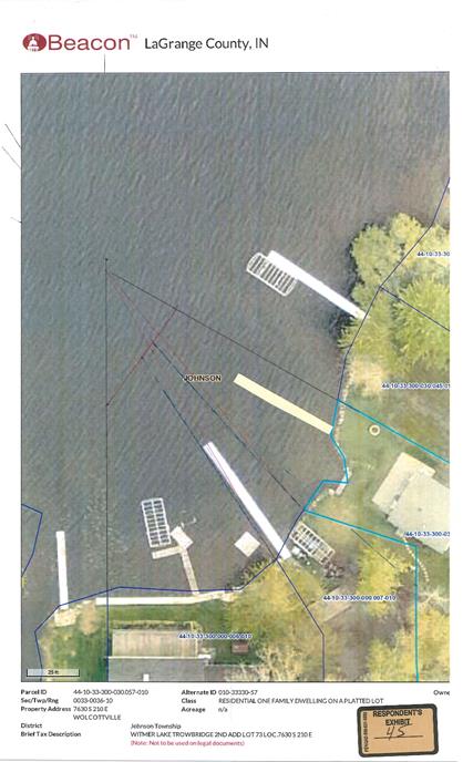
![]()
![]()
23. Dr. Herb J. Halley (Halley), a retired pharmacy professor, owned Lot 73 and half of Lot 72 in Trowbridge Second Addition, as seasonal residents, from 1994 until 2004. See testimony of Halley and Ex. 9.
24. When piers were being installed in 1995, Halley asked the Englands to honor the property lines by using less of the overall beachfront. Halley recalled that the Englands had “quite a conglomeration of piers”. In 1995, George England (G. England) told Halley that “they needed access and once they had access, they could arrange their pier however, because it was public waters.” See testimony of Halley.
25. For the 1996 boating season, Halley altered the placement of his 30 foot pier to block the Englands’ ability to install perpendicular extensions to their pier. See testimony of Halley.
26. In 1996, on the Arends’ side of the Englands’ pier, G. England acknowledges that the “L” extension to the Arends’ pier and his own “L” at the end of the Englands’ 47 foot pier interfered with navigation in that “it would have probably been almost impossible to get a boat into the beach area.” See testimony of G. England.
27. In 1996, the Englands submitted an application to the Department for a temporary pier permit, PL-16,928. Ex. 1. Within the application, the Englands provided a sketch of their 1995 pier configuration. It is noted that the length of the Arends’ frontage is actually 82 feet. In addition, the Halleys’ frontage was actually 95.5 feet, with the current Ball frontage being 64.2 feet. The sketch follows:
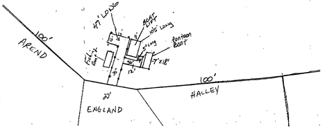
Ex. 1, p. 20.
28. On August 16, 1996, the Department approved permit PL-16,928 authorizing the Englands’ installation of a 3 foot wide temporary pier. The Department’s permit approval included special conditions that limited the pier length to 47 feet lakeward of the legal shoreline and disallowed the addition of any perpendicular segment or platform to the side of the pier. The permit designated that all watercraft were to be moored parallel to the pier, with no watercraft to be moored or otherwise extend beyond the lakeward end of the pier. Ex. 1, p. 3 and 6; Ex. 2, p. 13.
29. In 1996, Halley submitted an application to the Department for a temporary pier permit that was approved on October 18, 1996, as PL-16,936. Ex. 2.
30. In both of the temporary pier permits issued to Halley and the Englands’, the Department’s Division of Water noted “the placement of a temporary structure in a public freshwater lake is authorized without a written permit provided the structure is in conformity with Rule 310 IAC 6-2-14 concerning the placement of temporary structures. However, the Department…will require a permit from all affected parties in order to settle disputes involving the use and placement of temporary structures.” Ex. 1, p. 10 and Ex. 2, p. 9.
31. Subsequent to the approval of permit PL-16,928, G. England installed a straight 47' x 3' wooden pier, with external posts that extended approximately 4 inches beyond the pier’s width. At that time, the Englands moored a pontoon on one side of the pier and a speed boat on the other. See testimony of G. England. See also Ex. 12-13 and 21.
32. In 2013, the Englands replaced their wooden temporary pier with an aluminum pier, measuring 64' x 4', with wheels that minimally extend beyond the pier’s width. The Englands did not obtain any approval to alter the dimensions of the previously permitted pier. See testimony of G. England.
33. While neither Ball nor the Arends have extended their piers over time, G. England perceives that he has a water depth issue that does not affect his neighbors. See testimony of G. England.
34. Insufficient evidence was submitted to support a finding of a specific water depth for any location out from the shoreline.
35. In 2004, Halley deeded Lot 73 to David Baer. See testimony of Halley. In 2015, Lot 73 was deeded to NGALA, Inc., an entity in which Ball has an interest. In 2017, NGALA, Inc. deeded Lot 73 to Ball. See testimony of Ball and Ex. 4-5.
36. In 2016, Ball engaged Taylor Engineering to prepare a survey identifying a wellhead. The survey also noted the placement of piers that were installed when the survey was prepared. At the time of the survey, Ball’s pier was approximately 40 feet in length with a single boat moored on the side opposite the Englands’ property. Ball installed his pier from the center of his shoreline in this configuration, based on the advice of a Conservation Officer, in a manner generally consistent with an extension of his northernmost onshore property boundary into the public waters. See the testimony of Ball and Ex. 10. The effect of Ball’s configuration was that his pier angled toward the Englands’ boat lift. Ex. 32[2].
37. In 2016, Ball and the Englands met with surveyor Kevin Michel (Michel), identified by the parties as an independent surveyor with expertise in the area of riparian surveying, to assist them in developing riparian boundary lines and identifying efficient and effective pier placements. Michel did not complete an actual riparian survey. Instead, Michel drew a sketch on an aerial photograph to estimate the location of riparian boundary lines and indicated on the photograph a suggested location for the Ball pier. See Paragraph 22 above and Ex. 45. Michel also suggested that the Englands would need to use only one side of their pier in order to stay within their riparian zone[3].
[VOLUME 15, PAGE 79]
38. By agreement of the parties, Michel was deposed on April 30, 2019, and his examination was stipulated by the parties and presented at the administrative hearing in lieu of Michel’s testimony[4]. Michel has an associate degree from Purdue in Civil Engineering Technology and a bachelor’s degree from the Indiana Institute of Technology. He has been licensed as a professional engineer since 1984 and has been a professional land surveyor since 1987. Michel has experience in the determination of riparian boundaries through the application of the riparian boundary principles set forth in Information Bulletin #56. Michel’s Deposition, p. 1-8.
39. Michel recommended to the Englands and Ball that a survey would be appropriate to determine exact boundary lines. Id. at 9.
40. During his meeting with the Englands and Ball, Michel applied general riparian principles to the shoreline relevant in this proceeding. First, Michel extended a projection of the Arends’ west property line and Ball’s northeasterly line into the waters of Witmer Lake until the lines reached a common point. Second, Michel, in red, made a mark from the two corners of the Englands’ shoreline out to the common point. Third, Michel approximated 75 or 80 feet into the waters from the shoreline on the lines he extended in step one and struck a line from the approximated distance on Arends’ extended property line to the same distance on Ball’s extended line. Fourth, Michel prorated the line he drew in step three based on the length of each shoreline for the Arends, the Englands and Ball and drew two blue lines, based on the proration to the shoreline where the Englands and Arends properties meet and the corner where the Englands and Ball’s properties meet. Id. See also Ex. 45 as depicted in Paragraph 22 of this decision.
41. The shoreline of the property currently owned by Ball includes an indent in the shoreline. The indent in the glacial stone shoreline is a shallow, sandy area used by Ball as a swimming area. See testimony of Ball. See also Ex. 1, p. 11; Ex. 10 and Ex. 45.
42. The indentation in the shoreline would increase the length of the shoreline for the Ball property. However, the increased distance would probably be less than 10%. See Michel’s Deposition, p. 14.
43. In 2017, after the parties met with Michel, Ball installed a temporary pier and placed a Jet Ski perpendicular to the end of the pier. See testimony of G. England, Ball and Ex. 37.
44. In 2018, with the temporary permission of his neighbor to the north, who is not a party to this proceeding, Ball installed his pier in the location where Halley previously placed a pier when Halley owned both Lot 73 and one half of Lot 72.
45. In 2018, the Englands’ pier was angled toward the riparian area of Ball, not straight out from the shore consistent with the Department’s permit, PL 16,928.
46. G. England determined that the 2018 configuration of the Ball pier did not interfere with the Englands’ pier and continued placement in that manner would not create a navigational safety issue. However, the temporary permission of Ball’s neighbor is not expected to continue in subsequent years. See testimony of G. England and Ball. See also Ex. I and Ex. 44[5].
47. G. England believes that the most recent configuration of his pier and moored watercraft is minimally different than when it was originally permitted. However, the weight of the evidence presented supports a conclusion that the configuration is more intrusive than the pier originally permitted. The Englands have increased the size of their boats, added boat lifts on both sides of their temporary pier and increased both the length and the width of their pier. Currently, on the Ball side of the Englands’ pier, the Englands typically moor a Sport Nautique speed boat on a boat lift that is 9' 6″ wide. The boat lift is approximately 4 inches out from the pier. Shoreward of the speed boat lift, moored to the pier in a perpendicular manner and extending into the water toward Ball’s riparian boundary is a stairway with four stairs that does not extend beyond the width of the speed boat. Shoreward of the stairway, moored to and perpendicular to the pier, is a 12 foot long Sea Nymph. On the Arends’ side of the England pier is a pontoon moored on a 10' 9″ wide lift. The lift was originally installed in 2017. Englands’ original 16' x 8' pontoon was replaced by an 18' x 8' pontoon and then, most recently, replaced by a 24' x 8' pontoon. See the testimony of G. England. See also Ex. 30 and 42.
48. The Arends have placed a temporary pier into the waters of Witmer Lake, 44 feet in length, in a consistent configuration for approximately 33 years. The configuration originally included a perpendicular pier platform extended from the pier, on the side of the pier facing the Englands’ riparian zone. Over time, the platform has been replaced by a Jet Ski and lift. The pier and configuration has consistently maintained a similar footprint over a period of years. See the Testimony of G. England and Ex. 14-16, 19 and 33.
49. Lilly pads and “muck” to the west of the Arends’ pier would hamper their placement of a pier any further to the west. To the east of the Arends’ pier, the England’s side, there is a “natural beach” area where children often play. See the testimony of Mary Arend (M. Arend).
50. While one or more parties described the riparian area as a “cove”, the weight of the evidence presented supports a finding that the overall trend of the shoreline for the properties at issue in this proceeding presents as a rounded corner, rather than a cove, because the area is not substantially round. Ex. 1, p. 19.
51. The Englands’ aluminum replacement pier has been most recently installed in a way that angles toward Ball’s riparian area. M. Arends has observed that the Englands’ pier is also closer to her riparian area that it has been in the past due to the increased width of the Englands’ pier, boats and their pontoon lift. While the Arends did not file a counterclaim in this proceeding, M. Arend remains concerned that the Englands’ watercraft are consistently being moored beyond the Englands’ riparian area boundary into the Arends’ riparian area. See testimony of Ball and M. Arend.
52. Due to the current location of the Arends’ and the Englands’ piers, M. Arends has difficulty navigating her boat and wave-runner in order to work on the watercraft or to put gas into her watercraft. M. Arend has additional concern for safe navigation that includes the safety of swimming children, especially when boats or a wave runner are in use. See testimony of M. Arend.
53. G. England perceives no navigation safety issue for him to navigate his 8½ feet wide boat around his current pier configuration, including his moored watercraft, and the Arends’ current pier configuration, including their moored watercraft. He estimates two feet of clearance on either side of the boat. See testimony of G. England.
C. Conclusions of Law
54. The Commission has adopted a rule defining a “riparian owner” to mean “…the owner of land…bound by a lake….” 312 IAC 11-2-19.
55. The Englands, the Arends and Ball are riparian owners.
56. A riparian owner typically enjoys rights that include: “(1) access to navigable water; (2) the right to build a pier out to the line of navigability; (3) the right to accretions; and (4) the right to a reasonable use of the water for general purposes such as boating, domestic use, etc.” Parkison v McCue, 831 N.E.2d 118, 128 (Ind. App. 2005).
57. Riparian owners may build a pier within the extension of their onshore boundaries only so far out as not to interfere with the use of the lake by others. Bath v Courts, 459 N.E.2d 72, 76 (Ind. App. 1984). Consistent with this concept, a riparian owner may install a temporary structure under a general license in accordance with 312 IAC 11-3-1. Limitations to the authority of a riparian owner in placing a temporary structure include the limitation that the structure may not “infringe on the access of an adjacent landowner to the public freshwater lake.” 312 IAC 11-3-1(b)(2).
58. Under the Lakes Preservation Act, administrative review by the Commission under IC 4-21.5-3 is authorized for disputes among persons with competing interests. IC 14-26-2-23(e)(3)(B).
59. In order to determine whether Ball’s temporary structure infringes or encroaches on the Englands’ riparian boundary zone, as alleged by the Englands, the common riparian boundary between Ball and the Englands must be determined.
60. The Arends were joined as parties to this proceeding at the request of the Englands so that the riparian interests of the Arends are also subject to evaluation in this case.
61. Information Bulletin #56 is an agency statement adopted in accordance with IC 4-22-7-7. While Information Bulletin #56 is widely followed to provide guidance and principles for determining riparian boundaries it does not have the effect of law. The overarching objective of the guidance document is that the “principles seek to accommodate the diverse characteristics of Indiana’s numerous public freshwater lakes. They are designed to provide riparian owners with equitable access to public waters….” Ex. A.
[VOLUME 15, PAGE 80]
62. Any method of apportionment applicable in establishing riparian zones must “divide the total navigable waterfront in proportion to the length of the actual shorelines of each owner taken according to the general trend of the shore.” Nosek v. Stryker, 309 N.W.2d 868, 872 (Wis. App., 1981) cited favorably in Lukis v. Ray, 888 N.E.2d 325 (Ind. App., 2008).
63. Information Bulletin #56, as its “Fourth Principle”, states, “[w]here the shore is irregular, and it is impossible to run lines at right angles to the shore for a just apportionment, the lines forming the boundaries between riparian zones should be run to divide the total navigable waterfront in proportion to the length of the shores of each owner taken according to the general trend of the shore…” Principle Four offers a variety of methods by which an appropriate apportionment may be accomplished based on the specific fact pattern that is presented. Ex. A. at pp. 6 and 7.
64. Without consideration of any area beyond the shoreline at issue in this proceeding, the shoreline at issue in this proceeding is a concave rounded corner but is not substantially round. As to the unique shoreline associated with the properties at issue in this proceeding, the proration method provides the application that best meets the overall objective of Principle Four of Information Bulletin #56. Ex A. at p 6.
65. An application of Principle Four requires a determination of the percentage of each shoreline to the total shoreline for the three properties. The total shoreline of the parties totals 173.2 feet, with 82 feet attributable to the Arends, 27 feet attributable to the Englands and the remaining 64.2 feet belonging to Ball. A proration of the riparian area based on the feet of shoreline as presented by the parties would result in approximately 47.34% of the total area for the Arends, 15.59% for the Englands and 37.07% for Ball.
66. Michel determined the riparian area for all three properties using Information Bulletin #56’s proration method under the Fourth Principle as discussed in Paragraph 40. Michel’s effort reasonably determines an estimate of the riparian zones associated with the shoreline owned by the Arends, the Englands and Ball. It is noted that this decision is limited to a determination of the riparian boundary line between the Arends and the Englands and the riparian boundary line between the Englands and Ball. The riparian area to be prorated is not intended to establish any boundary lines that does not involve the Englands’ riparian zone.
67. Michel’s analysis as depicted in Exhibit 45 and his application of Principle Four appears to generally divide the total navigable waterfront in proportion to the length of the shoreline owned by each party taken according to the general trend of the shore.
68. The common riparian boundary line between the Englands and Ball shall be established through the proration application of the Fourth Principle in Information Bulletin #56, as estimated by Michel and depicted in Exhibit 45.
69. Michel’s predictions are not exact and the parties will be required to obtain a riparian survey in order to establish the precise location of the Englands’ riparian zone boundary lines shared with the Arends and with Ball, respectively.
70. The Commission has routinely concluded that a buffer between piers and moored boats is necessary to provide for safe navigation. Xanders v Nixon Trust, 14 CADDNAR 33, 38 (2015), citing Rufenbarger & Rufenbarger v. Blue, et al., 11 CADDNAR 185 (2007); Havel & Stickelmeyer v. Fisher, et al., 11 CADDNAR 110, 119 (2007); Sims, et al. v. Outlook Cove, LLC and Outlook Cove Homeowners Ass’n, 10 CADDNAR 258, 279 (2006) and Roberts v. Beachview Properties, LLC, et al., 10 CADDNAR 125, 166 (2005).
71. Information Bulletin #56, page 2 states, “To assist with safe navigation, as well as to preserve the public trust and the rights of neighboring riparian owners, there ideally should be 10 feet of clearance on both sides (for a total of 20 feet) of the dividing line between riparian zones. At a minimum, a total of 10 feet is typically required that is clear of piers and moored boats, although the area may be used for loading and unloading boats and for active recreation.”
72. Consistent with the need for safe navigation and to preserve the public trust, a buffer on either side of each established riparian zone boundary is found to be appropriate.
73. In acknowledgement that the irregular shoreline of the area presents unique challenges, due to the concave nature of the shoreline associated with the properties at issue in this proceeding, strict application of Information Bulletin #56 with respect to establishing buffer zones is not reasonable. Safe navigation in this area requires a minimum of two feet on either side of an eight foot wide boat, a minimum of 12 feet of clearance.
74. Ideally, each riparian owner would bear the responsibility to contribute one half of the total required buffer. Smith v Simanton, 14 CADDNAR 103, 108 (2016). See also Wallace v. Stone, 14 CADDNAR 140, 147 (2017).
75. The Commission has required a greater degree of contribution to clear space from one riparian owner based on the length of a riparian owner’s shoreline or other authority to use a specific length of shoreline. N.G. Hatton Trust v. Young & Pfeiffer, 14 CADDNAR 176, 179 (2017). See also Xanders, supra at 39.
76. In order to acknowledge the smaller riparian area of the Englands, a necessary clearance area between the Arends’ and the Englands’ piers and moored watercraft requires nine feet of clearance on the Arends’ side and three feet on the Englands’ side of the common riparian boundary line between the Englands and the Arends.
77. In order to acknowledge the smaller riparian area of the Englands, a necessary clearance area between the Englands’ and Ball’s piers and moored watercraft requires four feet of clearance on the England’ side and eight feet on the Ball side of the common riparian boundary line between the Englands and Ball.
78. Each party may place or maintain a temporary structure, as authorized by 312 IAC 11-3-1, within the riparian zones as established in this order.
Final Order
1) The common riparian zone boundary line between the Englands and Ball shall be determined through the proration application of the Fourth Principle of Information Bulletin #56, implemented in a manner consistent with the application by Kevin Michel, as indicated by the blue line that begins at the common on shore property boundary between the Englands and Ball as depicted in the drawing prepared by Michel, incorporated in this decision at Paragraph 22.
2) The common riparian zone boundary line between the Englands and the Arends shall be determined through the proration application of the Fourth Principle of Information Bulletin #56, implemented in a manner consistent with the application by Kevin Michel, as indicated by the blue line that begins at the common on shore property boundary between the Arends and the Englands as depicted in the drawing prepared by Michel, incorporated in this decision at Paragraph 22.
3) It is recognized that the Englands, the Arends and Ball may be required to commission a professional survey to precisely identify the boundaries of their respective riparian zones as established by this order. To the extent the commissioning of a survey becomes necessary to precisely identify a riparian zone boundary, the two property owners impacted by the specific boundary being surveyed shall either:
(1) Agree upon a surveyor and share equally in the cost.
(2) Each commission an independent survey at their individual cost. In this case any discrepancies must be decided by the respective surveyors or by a third surveyor, the cost of which shall be shared equally.
4) For the common riparian boundary between the Arends and the Englands, the Arends are required to retain a buffer of nine feet and the Englands are required to retain a buffer of three feet.
5) For the common riparian boundary between the Englands and Ball, the Englands are required to retain a buffer of four feet and Ball is required to retain a buffer of eight feet.
6) No portion of a temporary structure, including watercraft moored to the temporary structure, may be maintained within a buffer zone.
[1] Findings of fact that may be construed as conclusions of law and conclusions of law that may be construed as findings of fact are so deemed.
[2] The photograph admitted as Exhibit 32 depicts the Ball pier on the right and the Englands’ pier on the left.
[3] Michel’s statement was objected to as hearsay. Under IC 4-21.5-3-26(a), the statement was allowed as hearsay.
[4] Initially, Attorney Snyder objected to Michel’s qualification as an expert in the field of riparian rights. However, at the administrative hearing, Attorney Snyder withdrew his objection.
[5] The photograph admitted as Exhibit I depicts the Ball pier on the left and the Englands’ pier in the center of the photograph. A view from the shore is depicted in Exhibit 44, with the Arends’ pier on the left, the Englands’ pier in the center and the Ball pier on the right.