CADDNAR
[CITE: N.G. Hatton Trust v. Young & Pfeiffer, 14 CADDNAR 176 (2017)]
[VOLUME 14, PAGE 176]
[Editor’s Note: Final Order follows Findings of Fact and Conclusions of Law.]
Cause #: 16-142W
Administrative Law Judge: Jensen
Caption: N.G. Hatton Trust v. Young & Pfeiffer
Attorneys: Snyder (N.G. Hatton Trust); pro se (Young’s & Pfeiffer)
Date: August 28, 2017
FINDINGS OF FACT AND CONCLUSIONS OF LAW WITH FINAL ORDER
PROCEDURAL BACKGROUND AND JURISDICTION
1. The Petitioner, N.G. Hatton Trust (the Trust), initiated the instant proceeding by filing its “Petition for Administrative Review” with the Natural Resources Commission (Commission) on October 10, 2016 seeking resolution of a pier dispute between the Trust and the Respondents, Robert D. and Ellen M. Young (the Young’s), and James M. Pfeiffer (Pfeiffer).
2. The Trust alleged in its Petition that the Young’s and Pfeiffer have placed piers and docked boats in the waters of Shriner Lake “in a fashion that prevents [the Trust] from maintaining its pier in its historical location.”
3. Shriner Lake is a public freshwater lake. Indiana Code § 14-26-2-3, Indiana Code § 14-26-2-24 and “Listing of Public Freshwater Lakes”, Information Bulletin # 61 (Seventh Amendment), June 22, 2017, DIN: 20170531-IR-312170269NRA.
4. Administrative review is procedurally governed by Indiana Code §§ 4-21.5-3 and 312 IAC 3.
5. Substantively, Indiana Code § 14-26-2-23(e)(3) and Administrative Rules adopted by the Commission at 312 IAC 11-1-3 are controlling.
6. The Commission is the ultimate authority with respect to the subject matter of this proceeding. Indiana Code § 4-21.5-1-15 and 312 IAC 3-1-2.
7. Administrative Law Judge Jensen was appointed to preside over this proceeding in accordance with Indiana Code § 14-10-2-2.
8. The Commission has jurisdiction over the parties and the subject matter of this proceeding.
9. A prehearing conference was conducted on November 10, 2016 at which time the parties, anticipated the ultimate need to conduct an administrative hearing and sought the establishment of a case management schedule. Deadlines were established for the filing of summary judgment motions, for the completion of discovery, and for the filing of witness and exhibit lists. A Telephone Status Conference and an Administrative Hearing were also scheduled.
10. No summary judgment motions were filed by any party. All parties filed witness and exhibit lists and participated in a Telephone Status Conference scheduled for and conducted on May 4, 2017.
11. The Administrative Hearing was conducted, as scheduled, on May 9, 2017.
12. The Trust and the Youngs availed themselves of the opportunity to file post-hearing briefs on June 8, 2017 and May 19, 2017, respectively.
13. Throughout the pendency of this proceeding, the Trust has been represented by counsel, Stephen R. Snyder. The Youngs represented their own interests except for a brief period between November 8, 2016 and November 17, 2016, when they were represented by counsel, Matthew R. Shipman. Pfeiffer has been self-represented throughout the pendency of this proceeding.
FINDINGS OF FACT[1]
14. Ron Rice’s (Rice) mother, Doris, is the Trustee of the Trust, which purchased “a part of Lot Number One (1) of William Chapman’s Addition to Tri-Lakes Resort…” (the “Trust Property”) from Jennifer L. Sickafoose (Sickafoose) in 1999. Testimony of Rice, Exhibit 1. Rice’s mother and her husband, Allen, have occupied the Trust Property since 1999. Testimony of Rice.
15. On May 3, 1995 Stanley and Barbara Sickafoose took title to what is now the Trust Property from Gregory M. Mapps. Exhibits G & H. Jennifer L. Sickafoose, the daughter of Stanley and Barbara, who is also Rice’s sister-in-law, took ownership of what is now the Trust Property in 1996. Testimony of Rice. From 1996 until the present, Rice has routinely visited the Trust Property and is familiar with the Trust Property, pier placement and the use of the pier.
16. It is accepted as fact that Rice routinely visits the Trust Property but the evidence suggests that he is not aware of all of the uses made of the property or the pier. Rice testified that as of the date of the administrative hearing in this case he has visited the Trust Property three times in 2017. The occurrence of events at the Trust Property and with the Trust’s pier without Rice’s knowledge would be expected.
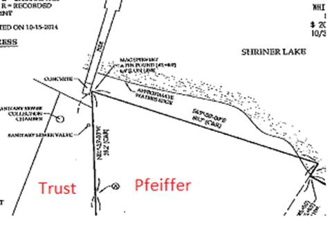
17. The Youngs are fee title owners of Lot Two and the portion of Lot One that is not owned by the Trust (the “Young Property”). Exhibit F. The Young Property is also situated in William Chapman’s Addition to Tri-Lakes Resort. Id.
18. The Young’s constructed a new residence up hill and further away from Shriner Lake and demolished the original cottage that had been situated near the Young Property’s northern boundary. Testimony of Rice, Exhibit 4. The evidence does not directly identify the specific time period associated with these construction and demolition events but the evidence supports the conclusion that this construction occurred after 1999.
19. William Chapman’s Addition to Tri-Lakes Resort was platted in 1921. Exhibit 13.
20. The plat of William Chapman’s Addition to Tri-Lakes Resort (the Plat) states that “the North line of said plat is approximately parallel with the water line on the South shore of Shriner Lake.” Further, noted is the existence of a six foot wide “public walk on the North side of Lots…” (Hereafter referred to as “the Walk”). Exhibits 12, & 13.
21. Aside from identifying the Walk on the north side of the Lots as “public”, the Plat provides no insight as to the platter’s intended purpose for the Walk.
22. Neither the Trust Property, nor the Young Property abuts the shoreline of Shriner Lake; the real property being separated from the shore of Shriner Lake by the Walk. Testimony of Michel, Exhibits 12, 13, 16 and G.
23. It is the northern boundary of the Trust Property and the Young Property that lies closest to the shoreline of Shriner Lake.
24. The Trust’s northern real property boundary is 12.5 feet in length from east to west and the Youngs’ northern real property boundary is 61.5 feet in length from east to west.
25. Pfeiffer is the fee title owner of real property lying immediately adjacent to the eastern boundary of Lot One in William Chapman’s Addition to Tri-Lakes Resort, which is also the eastern real property boundary of the Trust Property. Exhibit 11.
26. Pfeiffer’s real property is described by a metes and bounds description and is not located in William Chapman’s Addition to Tri-Lakes Resort. Id. Pfeiffer’s real property is described as follows:
Commencing at a point on the East line of Lot Number 1 in Chapman’s Addition to Shriner Lake, said point is 2169.6 feet North of the Southwest Corner of said East Half; thence North along the said East line 153.2 feet; thence South 69 degrees 30 minutes East, 80.7 feet; thence South 30 degrees 00 minutes West, 144 fee’ to the point of beginning, containing 0.14 acre, more or less, along with a 12 foot wide easement lying adjacent to the Southeast line of the above described parcel.
(the “Pfeiffer Property”). Exhibit 11.
27. The legal description of the Pfeiffer Property does not reference the shoreline of Shriner Lake although the 80.7 foot northern boundary of the Pfeiffer Property is situated generally parallel to the shoreline. Exhibits 11 & 17. With the exception of a very small area on the northeast corner, a survey of the Pfeiffer Property, dated October 24, 2014, identifies the existence of land lying between the northern boundary of the Pfeiffer Property and the shoreline of Shriner Lake. Exhibit 17.
28. The shared real property boundary between the Pfeiffer Property and the Trust Property, which forms Pfeiffer’s western real property boundary and the Trust’s eastern real property boundary, end at different northern-most points. It becomes important to the discussion that the northern-most point of the Trust’s eastern real property boundary is a greater distance away from the shore of Shriner Lake than is the northern-most point of Pfeiffer’s western real property boundary. Exhibit 17. Also important to note is the observation that this shared real property boundary extends toward Shriner Lake angling in a northwesterly direction. The extension of this property boundary to its intersections with the shore of Shriner lake has the effect of increasing the shoreline area associated with the Pfeiffer Property while decreasing the area of shoreline corresponding to the lateral property boundary lines of the Trust Property. Testimony of Kevin R. Michel. See Diagram 1, taken from Exhibit 17.
29. Despite acknowledging that their onshore property boundary lines do not reach the shoreline of Shriner Lake, both the Trust and the Youngs consider that the ownership of their respective real properties entitle them to exercise riparian rights lakeward of the shoreline within the lateral limitations of their onshore property boundary lines.
30. Prior to Sickafoose’s ownership of the Trust Property in 1996, a straight pier extended from an old concrete pad located on the Walk along the shoreline of Shriner Lake within the lateral onshore real property boundaries of the Trust Property. Testimony of Rice & Michel, Exhibits 2 & 3. The pier was outfitted with tires as bumpers on both sides. Exhibits 2 & 3. The reasonable conclusion drawn from the photographs, in which Gregory M. Mapps (Mapps) appears according to the testimony of Ellen M. Young, is that boats were moored on both sides of the pier as early as 1995, when Mapps was the owner of the Trust Property. In fact, photographs reveal a boat moored on the east side of the pier when the Trust Property was owned by Mapps. Exhibit 2. In more recent years, the tires used as bumpers have been replaced by carpet covered “one by sixes” installed parallel to each side of the Trust’s pier. Testimony of Rice, Exhibits 15, Youngs’ Exhibit E, Pfeiffer’s Exhibits A, B, & C
[VOLUME 14, PAGE 177]
31. Photographs taken when the Youngs were demolishing their old cottage evidences the Trust’s pier to be in the same location as it was before 1996. Testimony of Rice, Exhibit 4. Aerial photographs provide evidence that the Trust’s pier remained in the same location in 2011 and 2016 as well. Testimony of Rice, Exhibits 5, 6, & 7.
32. There is no evidence in the record to dispute the Trust’s claim that its pier has been situated in the same location since before 1996.
33. The evidence establishes that the Trust routinely moored a pontoon boat on the east side and a speed boat on the west side of the Trust’s pier until 2016. Testimony of Rice, Exhibits 6, & 7.
34. In general the evidence reveals that the pontoon boat is always at the Trust’s pier and that “Doug[2]” moored an 84 inch wide speed boat at the Trust’s pier when he was there or the boat was being used. Rice’s father occasionally moored a 62 inch wide fishing boat at the Trust’s pier. Rice testified that no one has moored a boat on the west side of the Trust’s pier for approximately five or six years since one of them hit a post placed in the water by the Youngs.
35. Despite Rice’s testimony that no boats have been moored on the west side of the Trust’s pier for five or six years, the evidence reveals a ski boat moored on the west side of the Trust’s pier at a time Pfeiffer’s pontoon boat is also moored on shore adjacent to the Pfeiffer Property’s western real property boundary. Other evidence established that Pfeiffer’s pontoon boat was first moored in that location in 2016. It is reasonably concluded that, the west side of the Trust’s pier was being used to moor boats as recently as 2016[3]. Pfeiffer’s Exhibits A, B, & C.
36. There is no evidence in the record disputing the Trust’s contention that boats have been moored on both sides of its pier since before 1996.
37. According to Robert D. Young (R. Young), the west edge of the Trust’s pier at the landward end is 7.4 feet east of the Trust Property’s west onshore real property boundary, which also forms the Young Property’s east onshore real property boundary. The Trust’s pier is wider at the lakeward end and is, according to R. Young, only 5.4 feet east of the shared onshore real property boundary of the Trust Property and the Young Property. Testimony of R. Young. The distances provided by R. Young were not the result of a survey but were not disputed by the Trust. The distances are accepted as generally accurate but subject to alteration based upon a professional survey.
38. While Rice testified to his belief that the Youngs’ pier has been relocated to the west since 1996 the evidence indicates that the Youngs’ pier has been located in the same, or very near the same, location for the duration of the time relevant to this proceeding. Testimony of (R. Young), Exhibits 3, 4, 6, 7, B (Youngs) & B (Pfeiffer). R. Young testified that the Youngs’ pier has been attached to the same concrete pad located on the Walk adjacent to the shoreline since 1962 when constructed by his father. Youngs’ Exhibit B.
39. Rice acknowledged that he had not conducted any measurements and only believed the Youngs’ pier had been moved. Rice’s testimony does not overcome the photographic evidence depicting the Young’s pier to be affixed to the same concrete pad in 1978 and during the demolition of the old cottage after 1999. Compare Exhibits 4, & B (Youngs’). The pier also remains affixed to what appears to be the same concrete pad in aerial photographs taken in more recent years. Exhibits 6, 7, 9, & 14.
40. One difference in the Youngs’ pier is evident but not significant to this proceeding. An “L” extension to the west with a covered boat lift affixed to the western end of the “L” has been added over the years. Compare Exhibits 6, 7, & B (Pfeiffer) to B (Youngs).
41. Rice testified that the Youngs placed a post in water in the “late 2000s to mark the property line as it extended into the lake.” Testimony of Rice, Exhibit 9. R. Young maintains that the post complained of by the Trust has been in the water in the same location and in the same manner since as early as 1978 when it was used as an additional mooring point for the back of his father’s boat. Testimony of R. Young, Youngs’ Exhibit B.
42. The post is located within five to six feet of the west side of the Trust’s pier[4] and appears to be approximately two to three feet landward from the terminal end of the Trust’s pier. Testimony of Rice, Compare Exhibits 10, & 15. This location is generally consistent with R. Young’s testimony that the post is located eight feet east of the Youngs’ pier and one foot inside a riparian zone that would be created by an extension lakeward of the lateral boundaries of the Young Property.
43. Rice and the Youngs dispute whether the post is rigidly affixed or whether the post is capable of being swayed by water current. Testimony of Rice & R. Young. The evidence overall supports a conclusion that the post is able to sway with the current, which places it closer to the Trust’s pier on one occasion and further away on another occasion. Rice’s efforts to “bend” the post and it is presumed that Rice merely swung it in another direction as opposed to actually bending the metal pipe which makes up the post.
44. From the evidence it cannot be conclusively determined that the post complained of by the Trust, as depicted in Exhibit 10, is one in the same with the post used to tie the rear of the boat depicted in the Youngs’ Exhibit B. However, this conclusion is reasonable.
45. In any event, the testimony is undisputed that the post is a metal pipe affixed to the bottom of the lake of a length that, depending upon the depth of the water, may be visible above the surface of the water or may be slightly below the water’s surface. Testimony of Rice, Exhibit 10. The post is not identified by a buoy and is not of a color that would be readily identifiable to a watercraft operator. Exhibit 10. Rice swung the post out of the way on repeated occasions in or near 2012 or 2013 to eliminate a hazard to the Trust’s watercraft but the post was always straightened. Testimony of Rice. R. Young acknowledged that when he swam in the area he did straighten the post to be immediately above its base. Testimony of R. Young. Rice ceased his own efforts to swing the post out of the way but in the early spring 2017 when a fishing boat operator complained to Rice’s nephew after hitting the post, the nephew bent the post over again to eliminate the hazard[5]. Testimony of Rice.
46. Evidence confirms that the post is a hazard to navigation and is not easily removed from the waters of Shriner Lake. Testimony of Rice & R. Young.
47. To moor a boat on the west side of the Trust’s pier a boat must be navigated west and then back east to the west side of the Trust’s pier because of the navigation hazard caused by the post. Testimony of Rice.
48. Between 2015 and 2016 the original cottage existing on the Pfeiffer Property was razed and a new home was constructed. Testimony of Rice, Exhibits 7, 8, & 9.
49. Before 2016 one pier extended from the Pfeiffer Property shoreline near the center of the property’s lateral boundaries. In or near 2016 a second pier was extended from the shoreline of the Pfeiffer Property from a point nearer the eastern property boundary. Testimony of Rice, Compare Exhibits 8, 9, & 14. In addition to adding the second pier, in the spring of 2016, Pfeiffer began mooring his pontoon boat on the shore immediately adjacent to the western real property boundary of the Pfeiffer Property, which is shared with the eastern real property boundary of the Trust Property. Testimony of Rice, Exhibits 9, 15, Youngs’ E, Pfeiffer’s A, B, & C.
50. Kevin R. Michel (Michel), an employee of Walker and Associates, P.C., is a professional land surveyor and professional engineer. Testimony of Michel. Michel holds a Bachelor Degree from the Indiana Institute of Technology in Engineering and has 43 years of experience in his professional fields. Michel has had frequent opportunities to survey, evaluate and offer opinions regarding riparian areas associated with lakefront properties. Michel has testified numerous times on such matters in proceedings in Court and before the Commission. Id.
51. Michel surveyed both the Trust Property and the Pfeiffer Property. Id, Exhibit 16, & 17.
52. The majority of the piers extended into Shriner Lake both east and west of the Trust Property meet the shoreline in a generally perpendicular fashion and riparian areas are established by the extension of onshore property boundaries lakeward. Testimony of Michel, Exhibits 6, 7, & 14. The exceptions to this general trend appears to involve the Trust Property, the Pfeiffer Property and approximately three properties to the east of Pfeiffer. Exhibit 14. The onshore property boundaries of these properties do not intersect with the shore of Shriner Lake at a perpendicular angle. Id.
53. Relying upon the Commission’s “Riparian Zones Within Public Freshwater Lakes and Navigable Waters”, Information Bulletin #56 (Second Amendment) published in the Indiana Register on March 31, 2010, http://www.in.gov/legislative/iac/20100331-IR-312100175NRA.xml.pdf, (“IB #56”), Michel offered the opinion that the riparian zone boundary between the Trust Property and the Pfeiffer Property should be established by Principle 3, or by extending lines perpendicular to the shoreline from the point at which the onshore real property boundaries intersect the shore. Michel clarified however, that because the Pfeiffer boundary line extends further northward and is located closer to the shore of Shriner Lake, the perpendicular line into the waters of Shriner Lake by which the Trust’s west and Pfeiffer’s east riparian zone boundaries should properly begin at the northwest corner of Pfeiffer’s real property boundary. See Finding 28.
54. Michel offered the further opinion that the riparian zone boundary between the Trust Property and the Young Property should be accomplished through the use of Principle 2, or simply extending onshore real property boundaries lakeward. Michel offered that because the shared landward boundary between the Trust Property and the Young Property, if extended to the shoreline, meet the shoreline at a near 90 degree angle, establishing the riparian zone boundary according to Principle 2 is most appropriate under IB #56.
55. No party disputed the opinions of Michel.
56. Use of two different Principles of IB #56 in this instance results from the fact that the onshore boundary line between the Trust and the Pfeiffer Properties, if extended to the shore, would meet the shoreline at an acute/obtuse angle whereas the onshore boundary between the Trust and the Young Property, if extended, would meet the shoreline at a near perpendicular angle.
57. By establishing a riparian zone for the Trust Property in this way, placement of the Trust’s pier in its historical location appears to be within the boundaries of the Trust’s riparian zone with limited mooring capability on either side.
58. The evidence presented does not include a survey of the riparian zone boundaries established by the Principles of IB #56 as identified by Michel and for this reason the exact location of the Trust’s riparian zone boundaries cannot be ascertained. The dimensions of the Trust’s riparian zone is not known. Generally, the evidence suggests that there will exist approximately 7.5 feet between the west side of the Trust’s pier and the Trust’s west riparian zone boundary, shared with the Youngs, for mooring watercraft[6]. Further, the evidence suggests that the Trust will have approximately two feet between the east side of its pier and the Trust’s east riparian zone boundary, shared with Pfeiffer.
59. A survey of the riparian zones will be necessary to identify the Trust’s riparian zone boundaries with specificity.
CONCLUSIONS OF LAW
60. The instant proceeding involves a dispute regarding the placement of piers within the waters of Shriner Lake, which is a public freshwater lake.
61. Activities occurring lakeward of the legally established shoreline of Indiana’s public freshwater lakes are controlled by the State of Indiana, which holds the lakes in trust for the benefit of the public, who possess a vested right in the preservation, protection and enjoyment of the lakes and in the use of the lakes for recreational purposes. Ind. Code § 14-26-2-5.
62. As relevant to this proceeding, except as otherwise authorized by law and administrative rule, a person is prohibited from “plac[ing], modify[ing], or repair[ing] a temporary or permanent structure” without first obtaining a permit from the Department of Natural Resources. Ind. Code § 14-26-2-23(a). At Indiana Code § 14-26-2-23(e)(2)(B) the Commission was obligated to adopt administrative rules “exempt[ing] any class of activities from licensing, including temporary structures, if the commission finds that the class is unlikely to pose more than a minimal potential for harm to the public rights…”
63. A “temporary structure” is “a structure that can be installed and removed from the waters of a public freshwater lake without using a crane, bulldozer, backhoe, or similar heavy or large machinery.” 312 IAC 11-2-25. A temporary structure includes a pier that is supported by poles that are not mounted in concrete. Id.
64. A “permanent structure” is “a structure that does not qualify as a temporary structure.” 312 IAC 11-2-16.
65. The Commission was tasked with developing a process, under Indiana Code §§ 4-21.5, for the mediation and resolution of disputes between persons having competing interests relating to the placement of temporary structures lakeward of the shoreline of a public freshwater lake. Indiana Code § 14-26-2-23(e)(3). The established process authorizes a person to “seek administrative review of the placement or maintenance of a [temporary structure]. 312 IAC 11-3-2(a).
66. A temporary structure may be placed and maintained within the waters of a public freshwater lake if the temporary structure satisfies express conditions. The conditions applicable to this proceeding include the following:
a. “Be easily removed.”
b. “Not infringe on the access of an adjacent landowner to the public freshwater lake.”
c. “Not unduly restrict navigation.”
d. “Be placed by a riparian owner or with the written approval of a riparian owner.”
312 IAC 11-3-1(b).
[VOLUME 14, PAGE 178]
67. Placement of a “permanent structure” within the waters of a public freshwater requires a written license issued by the Department of Natural Resources (Department). 312 IAC 11-3-3(a).
68. A “riparian owner” is “an owner of land, or the owner of an interest in land sufficient to establish the same legal standing as the owner of land, bound by a lake.” 312 IAC 11-2-19.
69. To carry out its obligation to resolve disputes between property owners having competing interests associated with the placement and maintenance of temporary structures lakeward of the shoreline of a public freshwater lake, the Commission may, to the extent necessary, determine landward property rights. Kranz v. Meyers Subdivision Prop. Owners Ass’n, 969 N.E.2d 1068 (Ind. Ct. App., 2012); see also Bowman v. Walls, 14 CADDNAR 85 (2016); Scheiber v. Mast, 14 CADDNAR 133 (2016);
Accretion Rights
70. “Generally, a property owner whose property abuts a lake, river, or stream possesses certain riparian rights associated with ownership of such a property. The rights associated with riparian ownership generally include: (1) the right of access to navigable water; (2) the right to build a pier out to the line of navigability; (3) the right to accretions; and (4) the right to a reasonable use of the water for general purposes such as boating, domestic use, etc.” Parkison v. McCue, 831 N.E.2d 118, 128 (Ind. App., 2005), (emphasis added & footnote omitted) citing Tennant v. Recreation Dev. Corp., 72 Mich. App. 183, 186, 249 N.W.2d 348, 349 (1976) (citing Hilt v. Weber, 252 Mich. 198, 225, 233 N.W. 159 (1930)).
71. “Accretion rights in public freshwater lakes are limited to land from which the waters have receded or may recede from natural causes only.” Indiana Code § 14-26-2-8.
72. The metes and bounds description of Pfeiffer’s real property does not reference the shoreline of Shriner Lake and aerial photographs depicting the Pfeiffer Property and the survey of the Pfeiffer Property indicate that land exists between the northern property boundary of the Pfeiffer Property and the shoreline of Shriner Lake except in the most northeasterly corner.
73. The legal description may be based on an established legal shoreline but there is no evidence to support this conclusion.
74. While the evidence presented in this proceeding fails to definitively resolve the question whether the Pfeiffer Property actually lies adjacent to the shoreline of Shriner Lake except in the northeast corner, the evidence similarly fails to establish any basis for a determination that another person is the owner of or has an ownership interest in the land situated between the Pfeiffer Property’s northern boundary and the shoreline of Shriner Lake.
75. There is no evidence that the land lying between the northern boundary of the Pfeiffer Property, as stated in the legal description, resulted from drainage of Shriner Lake, by the filling of Shriner Lake or by any other non-natural occurrence.
76. Taking the evidence presented in this proceeding as a whole, it is reasonably concluded that the land area existing between the Pfeiffer Property’s northern boundary, as stated in the legal description, and the actual shoreline of Shriner Lake is natural accretion to which Pfeiffer is entitled to benefit.[7]
77. “‘The question is well settled at common law that the person whose land is bounded by a stream of water, which changes its course gradually by alluvial formations, shall still hold the same boundary, including the accumulated soil. No other rule can be applied on just principles.’” Town of Freedom v. Norris, 27 N.E. 869, 870 (Ind. 1891) citing New Orleans v. U.S., 10 PET. 660. See also, Longabaugh v. Johnson, 321 N.E.2d 865 (Ind. App. 1975) and Parkison v. McCue, 831 N.E.2d 118 (Ind. App. 2005).
78. As noted in Finding 28, the east onshore boundary of the Trust Property, is one in the same with the west onshore boundary of the Pfeiffer Property, until that boundary reached the north real property boundary of the Trust Property at which point the Pfeiffer Property’s west boundary is in common with the east boundary of the platted Walk. Because this onshore boundary angles to the northwest as it approaches the shore of Shriner Lake an extension of that boundary serves to increase the length of Pfeiffer’s shoreline while decreasing shoreline of the Walk corresponding to the Trust Property’s lateral onshore boundary lines.
Pfeiffer Property
79. For purposes of this proceeding the full length of the Pfeiffer Property’s northern boundary is determined to lie adjacent to the shoreline of Shriner Lake.
80. The exact point at which the west boundary of the Pfeiffer Property, shared with the east boundary of the Walk in William Chapman’s Addition to Tri-Lake Resort, intersects the shoreline of Shriner Lake is not determinable from the evidence of record.
81. Pfeiffer is determined to be a riparian owner by virtue of his fee title ownership of real property bound by the shoreline of Shriner Lake. 312 IAC 11-2-19.
82. From evidence that the Pfeiffer Property’s shoreline has been extended westward by accretion, which has had the corresponding effect of reducing the length of the shoreline of the Walk attributable to the lateral boundaries of the Trust Property, it is deduced that the Trust’s predecessors in title possibly historically enjoyed greater separation between the west side of the pier and the boundary line shared by the Pfeiffer Property and the Trust Property.
Prescriptive Easement
83. The Trust maintains that it has acquired a prescriptive easement to exercise riparian rights associated with a portion of the Pfeiffer Property’s shoreline extending east from the Pfeiffer Property’s west onshore property boundary line.
84. “‘An unexplained use for 20 years’ of an obvious path or road for ingress and egress over the lands of another creates a rebuttable presumption that a use was adverse. However, we are unwilling to recognize such a presumption in favor of a party trying to establish a prescriptive easement for the recreational use of a body of water. This is because recreational use (especially of a body of water) is of a very different character from use of a path or road for ingress and egress over land. Recreational use (especially of water which leaves no telltale path or road) seems to us likely to be permissive…” Consequently, establishment of a prescriptive easement for the recreational use of water must be established by clear and convincing evidence. Carnahan v. Moriah Property Owners Ass'n, Inc., 716 N.E.2d 437, 442 (Ind., 1999).
85. “Prescriptive easements are not favored in the law” and must be established through “clear and convincing proof of (1) control, (2) intent, (3) notice, and (4) duration” as set forth for adverse possession in Fraley v. Minger, 829 N.E. 2d 476 (Ind. 2005) and applied to the establishment of prescriptive easements in Wilfong v. Cessna Corp., 838 N.E. 2d 403 (Ind. 2005). See Bass v. Salyer, 923 N.E.2d 961, 964-965 (Ind.App.,2010). The proof required for the establishment of a prescriptive easement is more specifically described as:
(1) Control–The claimant must exercise a degree of use and control over the parcel that is normal and customary considering the characteristics of the land (reflecting the former elements of “actual,” and in some ways “exclusive,” possession);
(2) Intent–The claimant must demonstrate intent to claim full ownership of the tract superior to the rights of all others, particularly the legal owner (reflecting the former elements of “claim of right,” “exclusive,” “hostile,” and “adverse”);
(3) Notice–The claimant's actions with respect to the land must be sufficient to give actual or constructive notice to the legal owner of the claimant's intent and exclusive control (reflecting the former “visible,” “open,” “notorious,” and in some ways the “hostile,” elements); and,
(4) Duration–the claimant must satisfy each of these elements continuously for the required period of time (reflecting the former “continuous” element). Wallace v. Stone, 14 CADDNAR 140 (2017), citing Bass, at 965
86. With respect to the element of control, “the use required need only be in keeping with the ordinary uses of the land.” Fraley, supra, at 487.
87. It is not in dispute that the Trust, Sickafoose and Mapps moored a boat on the east side of a pier maintained in the same location extending from the Walk within the lateral onshore property boundaries of the Trust Property. Testimony of Rice, Exhibit 2. The mooring of a boat in this location is not an act that was concealed or shrouded from the view of Pfeiffer or Pfeiffer’s predecessors in title such that they were not on notice that the Trust, and its predecessors in title were using the area for the purpose of mooring a boat. Furthermore, the act of mooring a boat along the east side of the Trust’s pier lakeward of the Pfeiffer Property’s shoreline would clearly have prevented Pfeiffer or Pfeiffer’s predecessor in title from also using that area. Pfeiffer presented no evidence whatsoever to contradict the evidence upon which these conclusions are based.
88. The fact that the Trust’s use was clearly observable and contrary to the interests of Pfeiffer and his predecessors in title is found in Pfeiffer’s actions of mooring his pontoon boat on the shore along-side the west onshore property boundary of the Pfeiffer property in 2016, which is reasonably viewed to be Pfeiffer’s attempt to terminate the Trust’s use of the shoreline associated with the Pfeiffer Property.
89. While use of the area east of the Trust’s pier for mooring a boat may not have been constant, the use of the area was consistent with the ordinary use that might be made of the area.
90. Further, there is no evidence in the record that the use of the Pfeiffer Property shoreline area immediately east of the Trust’s pier was by a grant of permission by Pfeiffer or his predecessor(s) in title.
91. “Continuity of use in determining the 20 year period “may be established by tacking from the use of predecessors in title.” Wallace v. Stone, 14 CADDNAR 140 (2017), citing Downing v Owens, 809 NE 2d 444, 450, citing DeShields v Joest, 34 N.E.2d 168, 170 (Ind. App. 1941).
92. “Once title vests in a party as the conclusion of the [required] possessory period, the title may not be lost, abandoned, or forfeited…” Fraley, supra, at 487. Therefore, once the Trust had acquired a prescriptive easement to exercise riparian rights associated with the portion of Pfeiffer’s riparian zone lying east of the Pfeiffer Property’s west onshore boundary line in 2015 by use for the requisite 20 year possessory period, the Trust’s property interest could not be terminated by Pfeiffer’s actions to stop the Trust’s exercise of those riparian rights in 2016.
93. Pfeiffer’s attempt to terminate the Trust’s use occurred in 2016, at a point in time after the Trust’s use combined with the use of the Trust’s predecessors in title had already been occurring for at least 20 years.
94. “It may be remarked at the outset that it is well settled at common law that one owning land in fee, bounded by a stream of water, is the owner of all the accretions to such land caused by a gradual change in the channel of such stream. When such land is subject to an easement, the question as to whether such accretions become a part of the easement depends, of necessity, upon the nature of the easement, the intention, express or implied, of the party granting or dedicating the same, and the intention of those accepting and acting upon such grant or dedication. If one owning land bounded by a steam should dedicate a public highway running parallel with the stream, and extending to the water's edge, and accretions should take place beyond the highway, not necessary to its use, it could not be contended with reason that such addition to the land belonged to the public, or was subject to the easement granted. But if one owning the fee should dedicate a public highway running to a public ferry or to a public dock or boat-landing, and accretions should take place after the dedication, over which it was necessary to pass in order to reach the ferry or dock, then such accretions would become subject to the easement so dedicated; otherwise the object of the donor would be defeated, and the public would suffer. The law, as applicable to the latter class of cases, is fully discussed and illustrated in the well-considered cases of Saulet v. Shepherd, 4 Wall. 502; Mayor, etc., of New Orleans v. Gravier, 11 Mart. (La.) 621; Municipality No. 2 v. Cotton Press, 18 La. 122; Cook v. City of Burlington, 30 Iowa, 94; and New Orleans v. U. S., 10 Pet. 660.” Town of Freedom, supra, at 870.
The Public Walk in William Chapman’s Addition to Tri-Lakes Resort
95. The northern property boundary of the Trust Property and the Young Property is not adjacent to the shoreline of Shriner Lake and for this reason neither the Trust, nor the Youngs, are riparian owners by virtue of the fee title ownership of property abutting the shoreline of Shriner Lake.
96. Despite the fact that the Trust and the Youngs are not riparian owners through fee title ownership this fact is not dispositive of whether they possess an interest in the Walk sufficient to exercise riparian rights associated with the Walk. Klotz v. Horn, 558 N.E.2d 1096, 1097 (Ind. 1990)
97. The plat of William Chapman’s Addition to Tri-Lakes Resort, established in 1921, is void of any description, either by way of express authorization or by express restriction, of the use for which the Walk may have been intended. The failure to provide direction regarding the intended purpose of the Walk results in ambiguity of the grant contained in the Plat.
98. The record of this proceeding lacks evidence regarding the actual use of the shoreline of Shriner Lake attributable to the Walk from 1921, when William Chapman’s Addition to Tri-Lakes Resort was platted, until 1962.
99. However, the evidence establishes that the Youngs’ predecessor in title, R. Young’s father, poured a concrete pad on the Walk in 1962 for a pier that was previously extended from the Walk’s shoreline in between the Young Property’s lateral onshore property boundaries. Testimony of R. Young.
100. It is undisputed that since 1962, the Youngs’ pier has been affixed to the concrete pad on the Walk from which it extends lakeward of the shoreline of Shriner Lake. Id.
[VOLUME 14, PAGE 179]
101. It is also undisputed that as early as 1978, R. Young’s father placed posts in the waters of Shriner Lake within those same lateral boundaries to assist with the mooring of boats. Id.
102. The evidence also confirms that the Trust property has maintained a pier extended from a concrete pad poured on the Walk since a date before 1996. Testimony of Rice.
103. Further, the aerial photographs taken between 2005 and 2016 reveal the existence of piers extended from the shoreline of the Walk consistent with the location of many, if not all, of the residences constructed within William Chapman’s Addition to Tri Lakes Resort. Exhibits 5, 6, & 8.
104. There is no evidence disputing the Youngs or the Trusts evidence that the owners of Lots in the William Chapman Addition to Tri Lakes Resort have historically extended piers from the Walk consistent with the lateral limitations of their onshore boundary lines.
105. The only conclusion logically drawn from the evidence available is that William Chapman, as the platter of the William Chapman Addition to Tri Lakes Resort, intended to allow the Lot owners to extend piers lakeward of the shoreline of the Walk within the lateral onshore boundaries of their respective Lots.
106. For this reason it is determined that the Trust and the Youngs are the owners of a property interest in the Walk sufficient to qualify them as riparian owners within the meaning of 312 IAC 11-2-19.
107. Consequently, the Youngs and the Trust are authorized to extend piers into the waters of Shriner Lake from the shoreline of the Walk located within the lateral onshore boundaries of their respective Lots.
Establishment of Riparian Zone Boundary Lines
108. Determination of the issues raised by the Trust requires only that two riparian zone boundaries be determined. One is the Trust’s east riparian zone boundary, which is also the western riparian zone boundary of Pfeiffer (hereafter referred to as the “Trust/Pfeiffer RZB”) and the other is the Trust’s west riparian zone boundary, which is also the east riparian zone boundary of the Youngs (hereafter referred to as the “Trust/Young RZB”).
109. Michel’s conclusion that the Trust/Young RZB is most appropriately determined by Principle 2 of IB #56 is supported by the remainder of the evidence of record and no party presented evidence contrary to Michel’s opinion.
110. The onshore real property boundary between the Trust Property and the Young Property shall be extended across the Public Walk as if that boundary reaches the shoreline of Shriner Lake to ascertain the point of intersection with the shoreline of Shriner Lake. From that point the onshore property boundary shall be extended lakeward in accordance with Principle 2 of IB #56 to establish the Trust/Young RZB.
111. Michel’s conclusion that the Trust/Pfeiffer RZB is most appropriately determined by Principle 3 of IB #56 is also supported by the remainder of the evidence of record. Again, no party presented evidence contrary to Michel’s opinion.
112. As stated in Finding 79, the surveys of record in this proceeding do not identify the point at which the west onshore property boundary of the Pfeiffer Property meets the shoreline of Shriner Lake. However, the west onshore property boundary shall be extended to identify the point of intersections with the shoreline. From that point of intersection, the Trust/Pfeiffer RZB shall commence to be identified in accordance with Principle 3 of IB #56.
113. Areas of clear space between piers, commonly referred to as buffer zones, are routinely required by the Commission. IB #56, pg. 2; Kranz, supra. In general it is preferred that a buffer zone be no less than five feet in width between a pier and a riparian zone boundary for a total of 10 feet but it is preferred for the buffer zone to be 10 feet between a pier and a riparian zone boundary for a total of 20 feet. Id. However, the Commission recognizes that in some instances the imposition of a buffer zone would effectively terminate a riparian owner’s ability to exercise his or her riparian rights. Xanders v. Nixon Trust, 14 CADDNAR 33 (2015); Lawson v. Halliwill, 13 CADDNAR 146 (2013).
114. The Trust’s exercise of riparian rights is limited to a relatively modest area of shoreline, which consists of 12.5 feet of shoreline plus a small prescriptive easement over a portion of Pfeiffer’s riparian zone. Imposition of even a five foot buffer would effectively prevent the Trust from using its riparian zone.
115. By comparison the Youngs’ shoreline is 61 feet in length and Pfeiffer’s shoreline of 80.7 feet in length minus the small portion to which the Trust has gained a prescriptive easement.
116. It is determined appropriate that the Youngs and Pfeiffer bear a larger burden associated with the maintenance of buffer zones between their piers and moored watercraft and the pier and moored watercraft maintained by the Trust.
Navigational Safety
117. The post placed into the waters of Shriner Lake by the Youngs has been hit by watercraft attempting to access the Trust’s pier as well as by a fishing boat occupied by a recreational user of Shriner Lake. Testimony of Rice.
118. The post placed into the waters of Shriner Lake is “impossible” to remove. Testimony of R. Young. This characterization is also supported by the testimony of Rice.
119. The evidence supports the conclusion that the post cannot be removed from the waters of Shriner Lake without the use of heavy equipment and therefore the post is not characterized as a “easily removable” as required for placement under a general license. 312 IAC 11-3-1(b).
120. In 2003, the Commission determined in Piering v. Ryan and Caso, 9 CADDNAR 123 (2003), that:
To fully enjoy their riparian rights, the Claimants need ready ingress and egress to their pier and their shoreline. That enjoyment may reasonably require temporary usage of Crooked Lake waters in proximity to their pier, and either east or west of their riparian area, for the purposes loading and unloading a boat. A temporary use of this nature does not unreasonably infringe on the riparian rights of the Respondents and is consistent with the Lakes Preservation Act and IC 14-15-3-17(a). The Claimants do not, however, reasonably require the usage of waters outside the Claimants' riparian area to permanently moor a boat. A usage of this nature would unreasonably interfere with the riparian rights of either the Ryans or the Casos, depending on whether the boat were moored west or east of the Claimants' riparian area.
121. Similarly, while the Trust may not permanently moor a boat in a manner that encroaches into the riparian zone of the Youngs, the Trust is authorized to navigate watercraft unimpeded and without risk of damage within the riparian zone of the Youngs for ingress, egress and other activities of a temporal character.
122. The evidence establishes that the post impedes the Trust’s proper use of the water of Shriner Lake thereby “unduly restrict[ing] navigation” and “infring[ing] on the access of an adjacent landowner to the public freshwater lake”, which disqualify the post from being placed and maintained within the waters of Shriner Lake under a general license. 312 IAC 11-3-1(b).
123. Indiana’s public freshwater lakes are held by the State of Indiana in trust for the benefit of the public who “has a vested right” to enjoy those public waters for recreation. McCulloch v. Day, 12 CADDNAR 85 (2009). “A person who is not a riparian owner has the lesser interests of the public in another person's riparian area. The public may enjoy natural scenic beauty and recreational values, such as navigation and fishing.” Barbee Villa Condominium Owners Assoc. v. Shrock, 10 CADDNAR 23, 26 (2005).
124. The evidence establishes that the post poses a hazard to navigation by the general public which interferes with the vested interests of the general public.
125. The post placed and maintained lakeward of the shoreline of Shriner Lake by the Youngs, cannot be maintained without a license issued by the Department.
FINAL ORDER
126. The metal post constructed and maintained by the Youngs lakeward of the shoreline of Shriner Lake are not temporary structures that qualify for placement and maintenance lakeward of the shoreline of Shriner Lake.
127. Within 30 days of the completion of opportunity for judicial review under Indiana Code § 4-21.5, the Youngs shall either:
a. Obtain an individual permit from the Department of Natural Resources to maintain the post, or
b. Remove the post.
128. The Trust/Young RZB shall be determined in accordance with Principle 2 of IB #56 with a point of commencement being the point at which the shared onshore boundary line extended intersects the shoreline of Shriner Lake.
129. The Trust shall not moor boats or other watercraft to its pier in a manner that encroaches into the riparian zone of the Youngs.
130. The Youngs shall maintain a buffer zone, or clear space of 3 feet between the Trust/Young RZB and the east side of any boat moored on the east side of the Youngs’ pier.
131. The Trust/Pfeiffer RZB shall be determined in accordance with Principle 3 of IB #56 with a point of commencement being the point at which the Pfeiffer Property’s west onshore boundary extended intersects the shoreline of Shriner Lake.
132. The Trust is granted a prescriptive easement to exercise the riparian rights associated with that portion of the Pfeiffer Property’s shoreline located immediately east of the Trust/Pfeiffer RZB as necessary to provide the Trust with a total of 10 feet of mooring space on the east side of the Trust’s current pier[8].
133. Pfeiffer must maintain a three foot buffer area or clear space between the east side of the Trust’s prescriptive easement and any pier or moored boat maintained by Pfeiffer.
134. Watercraft may navigate within the buffer zones established by this order, but watercraft shall not be moored in this space.
[1] Findings of fact that may most appropriately be characterized as conclusions of law and conclusions of law that may best be construed as findings of fact shall be so considered.
[2] The testimony did not identify the relationship of “Doug” to the Trust.
[3] This is not an indication that Rice’s testimony was false but indicates that since Rice does not occupy the Trust Property full time the pier is occasionally used in a manner unknown to him.
[4] This Finding was deduced from Rice’s testimony that a boat wider than four to five feet could not moor on the west side of the Trust’s pier without navigating around and mooring landward of the post.
[5] The testimony indicates that the nephew may have actually bent the pipe over in a more permanent way. R. Young testified that the post seemed to be gone.
[6] This is exclusive of the terminal end of the Trust’s pier upon which a deck and benches have been constructed and which is wider than the more landward portion of the pier.
[7] This ultimate finding of fact is binding only upon the parties to this proceeding and is made only for the purpose of determining the dispute associated with the parties’ placement of temporary structures within the waters of Shriner Lake. See generally, Kranz v. Meyers Subdivision Prop. Owners Ass’n, 969 N.E.2d 1068 (Ind. Ct. App., 2012).
[8] The evidence is undisputed that the nine foot wide pontoon boat historically moored on the east side of the Trust’s pier extended partially across the Trust/Pfeiffer RZB and it is reasonably understood that nominal amount of space is required to exist between the pier and the boat. The width of the Pfeiffer Property’s shoreline consumed by the Trust’s historic use cannot be definitively ascertained from the evidence but the total space of 10 feet between the east side of the Trust’s pier is consistent with the evidence of the historic use. For this reason the area to which the Trust is granted a prescriptive easement is described in this way for the purpose of limiting the prescriptive easement to the space historically used by the Trust and to provide sufficient data for preparation of a survey of the prescriptive easement area. The portion of Pfeiffer’s riparian zone subject to the prescriptive easement will not be altered by future modification of the Trust’s pier or by future accretions along the shoreline of the Pfeiffer Property or the Walk corresponding to the lateral onshore boundaries of the Trust Property.