[CITE: Dennis v. Sutton and Melendez, 14 CADDNAR 148 (2017)]
[VOLUME 14, PAGE 148]
Cause #: 16-021W
Caption: Dennis v. Sutton & Melendez
Administrative Law Judge: Jensen
Attorneys: Snyder (Dennis); Doyle (Sutton/Melendez)
Date: May 22, 2017
[Editor’s Note: Final Order follows Findings of Fact and Conclusions of Law.]
FINDINGS OF FACT AND CONCLUSIONS OF LAW
Case Summary and Jurisdiction
1. Petitioners, Robert C. Dennis and Marilyn S. Dennis, (collectively referred to as “the Petitioners”), by counsel, Stephen R. Snyder, filed their “Petition for Administrative Review” (“Petition”) with the Natural Resources Commission (“Commission”) on January 27, 2016 alleging the existence of a dispute involving the placement and maintenance of a pier on Sechrist Lake by Lucila Sutton and Gloria Melendez (“collectively referred to as “the Respondents).
2. The Petitioners’ maintain that they are the owners of a Lot in the First Addition to Nickel’s Park on Sechrist Lake (hereafter referred to as “Nickel’s Park”) situated adjacent to a “public way”, or strip of land identified in the plat of Nickel’s Park (hereafter referred to as “the disputed parcel”), both of which front on Sechrist Lake.
3. The Petitioners’ further contend that the Respondents, who are the owners of real property that does not border Sechrist Lake and that is situated outside the platted boundaries of Nickel’s Park, have placed and maintain a pier extending from the disputed parcel. The Petitioners’ present the following three issues for consideration by the Commission:
a) Whether Respondents have placed piers into the riparian area of [Petitioners].
b) Whether [Petitioners] are entitled to the full use of the shoreline of their property, including that area burdened by the [disputed parcel].
c) Whether Respondents have placed a pier into the water of Sechrist Lake in such a fashion as to interfere with the riparian rights of [Petitioners].
Petition ¶7.
4. Sechrist Lake, located in Kosciusko County, Indiana, is a public freshwater lake. Indiana Code § 14-26-2-3, Indiana Code § 14-26-2-24 and “Listing of Public Freshwater Lakes”, Information Bulletin # 61 (Fifth Amendment), February 1, 2016, DIN: 20160127-IR-312160050NRA.
5. The dispute presented by Petitioners is governed substantively by Indiana Code § 14-26-2-23(e)(3) and 312 IAC 11-1-3.
6. Administrative review in this context is procedurally controlled by Indiana Code §§ 4-21.5-3 and 312 IAC 3.
7. The Commission possesses jurisdiction over the parties and over the subject matter of this proceeding.
8. With respect to the subject matter and the parties to this proceeding the Commission serves as the “ultimate authority”. Indiana Code 4-21.5-1-15 and 312 IAC 3-1-2.
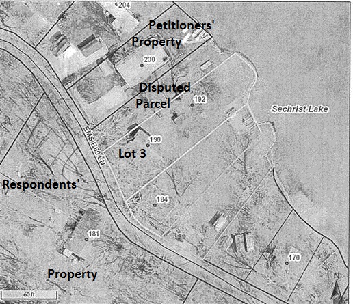
9. A prehearing conference was scheduled for and conducted on February 23, 2016. The Petitioners appeared by and have been represented throughout by counsel, Stephen R. Snyder and the Respondents appeared by and have been represented throughout by counsel, Craig D. Doyle.
10. The Department of Natural Resources (“Department”), appeared by counsel, Sean R. Wooding and Edward Harcourt[1], for the limited purpose of monitoring the instant proceeding by receiving filings, notices, reports, and orders. The Department is not a party.
11. On March 23, 2016, the Respondents filed “Respondents’ Response to Petition for Administrative Review” (“Response”), which includes their statement of affirmative defenses. More particularly, the Respondents maintain that the disputed parcel is a private right of way providing lake access to them and other owners of properties situated on Lakeview Drive that do not front on Sechrist Lake. The Respondents aver they have personally extended and maintained a pier from the disputed parcel for over14 years as their predecessors in title had done for a number of years prior. The Respondents present the following as affirmative defenses:
a) The administrative law judge lacks jurisdiction to determine the real property rights to the land at issue, and if the decision is based upon such a determination, the court should grant Respondents the presumption of title and the rights to the placement of a pier as has occurred in the past.
b) The petition … is barred under the doctrines of waiver, laches or estoppel.
c) The [Petitioners] have ratified historical pier locations and historical riparian areas.
Response.
12. Within their Response, the Respondents seek “a determination of the respective riparian rights of the parties, and that the [Petitioners] be ordered not to place their pier in such a way as to interfere with the riparian rights of the Respondents, or interfere with a private right-of-way, or public right-of-way as claimed by the [Petitioners].” Id.
13. A status conference was conducted by teleconference on March 30, 2016 at which time an administrative hearing was scheduled for July 28, 2016.
14. The parties filed and exchanged witness and exhibit lists and an administrative hearing was conducted as scheduled. At the conclusion of the administrative hearing the Administrative Law Judge requested the parties’ respective counsel to file post hearing briefs not later than September 12, 2016.
15. Post hearing briefs were timely filed by both the Petitioners and the Respondents on September 12, 2016.
Findings of Fact[2]
A. Real Property at Issue
16. Nickel’s Park was established in Kosciusko County on June 28, 1947 by Guy L. White and Fern L. White (collectively referred to as “the Whites”). Exhibit D.
17. The plat identifies the disputed parcel as a 25 foot wide strip of land situated between and sharing common boundary lines with Lot 3 and Lot 4 in Nickel’s Park. The plat references the disputed parcel simply as “ditch and RD to lake”. Exhibits 4 and D[3].
18. The Petitioners purchased Lot 4 in Nickel’s Park on August 5, 2014. (Lot 4 is hereafter referred to as “Petitioners’ Property”.) Testimony of Robert C. Dennis, Exhibit A.
19. Terry L. Dennis (“T. Dennis”) and his wife, Brenda S. Dennis[4] (Terry L. and Brenda S. Dennis are collectively referred to as “the Dennises”), who are not parties to the instant proceeding, have owned Lots 1, 2, and 3 in Nickel’s Park since 1987. The Dennises’ residence is located on Lot 2 and they maintain two rental cottages both of which are situated on Lot 3. Testimony of T. Dennis.
20. The Dennises’ Property, the Petitioners’ Property, and the disputed parcel are located between Lakeview Drive, also referred to as EMS B60 Lane, to the west (southwest), and Sechrist Lake to the east (northeast). Exhibit D.
21. On July 20, 2001, the Respondents purchased three tracts of real property situated to the west (southwest) of Lakeview Drive directly across Lakeview Drive from the Dennises’ Property, the Petitioners’ Property and the disputed parcel. (The three tracts are referred to as “Respondents’ Property”.) Testimony of David Sutton, Exhibit E.
22. The Respondents’ Property does not share a boundary with the shoreline of Sechrist Lake. Testimony of Leo Stults, Exhibit 4.
23. For demonstrative purposes a copy of the relevant portion of the property is reproduced here. Exhibit 4 (labels added).
[VOLUME 14, PAGE 149]
24. After executing the plat to Nickel’s Park on June 28, 1947 and recording the same on July 17, 1947, the Whites conveyed two easements over the disputed parcel. Exhibit C and 1.
25. The Respondents argue that the Whites’ conveyance of easements over the disputed parcel after the recordation of the plat evidences the Whites’ continuing control over the disputed parcel and confirms the Whites’ intent for the disputed parcel to be a private drive.
26. Conversely, the Petitioners assert that recordation of the plat established a public ditch and road to Sechrist Lake[5].
27. The Whites’ initial conveyance of the Petitioners’ Property occurred on July 19, 1947 and included an “easement over adjoining strip of land on designated on plat as ditch and road to lake.” Exhibit C (quoted as in original).
28. Despite the fact the Petitioners’ deed does not recite the July 19, 1947 easement, the fact that the easement was initially conveyed in conjunction with the original conveyance of the Petitioners’ Property indicates an intention that the easement would be appurtenant to and inseparable from the Petitioners’ Property. Exhibit A.
29. It is reasonably concluded that the Whites construed “ditch and RD to lake”, as expressed in the plat, to be synonymous with “ditch and road to lake”, as stated in the July 19, 1947 easement.[6]
30. Later, on October 25, 1947, the Whites granted a second easement over the disputed parcel to the then owner of Lot 3 in Nickel’s Park as follows:
This is to certify that Rex Clingenpell is to be given the use of a 25 ft. easement adjoining his lots on Sechrist Lake platted as First Addition to Nickels Park as a drive-way. No building is to be erected on this easement and it is to be kept accessible for the use of Lot No. 4 also.”
Testimony of T. Dennis, Exhibit 1.
31. It is recognized that the Dennises are not parties to this proceeding. The Commission expressly recognizes that any findings relating to the October 25, 1947 easement granted to Rex Clingenpell is not binding upon the Dennises. Discussion associated with the October 25, 1947 easement is considered herein for the sole purpose of determining the status of the disputed parcel as either a private drive or a public road. Conclusions reached and inferences drawn herein are strictly limited to this purpose.
32. Evidence does not support the conclusion that the October 25, 1947 easement was conveyed contemporaneous with the sale of Lot 3 and the language of conveyance does not reflect transferability or survivability through property transfer to the heirs, assigns or transferees of Rex Clingenpell. Exhibit 1. The evidence of record, which does not include a copy of the Dennises’ deed, indicates that the October 25, 1947 conveyance constituted an easement in gross conveyed personally to Rex Clingenpell that existed only during the time he owned Lot 3.
33. From the evidence of record it cannot be ascertained when Rex Clingenpell transferred title to Lot 3 to a subsequent owner.
34. T. Dennis was unaware of the October 25, 1947 easement. Testimony of T. Dennis. T. Dennis testified that he is uncertain as to the existence of a written easement over the disputed parcel for the benefit of Lot 3 but stated his belief that his use of the disputed parcel is “just like hand-me-down” the same as his predecessors in title, the Secrists and the Baliles. T. Dennis testified;
I have a verbal easement. I have a verbal agreement from not only the owners but the people that were next door and …(inaudible) ….grounds that was used to drive to the front cottage. [7]
Testimony of T. Dennis.
35. From the evidence it is reasonable to infer that the Dennises, like their predecessors in title, have continued to use the disputed parcel not as persons holding any easement right across the disputed parcel but as members of the public utilizing the disputed parcel as a ditch and road to the lake as it was identified by the Whites in the plat of Nickel’s Park.
36. There is no evidence in the record that the Whites conveyed an easement over the disputed parcel to the Respondents or any predecessor in title to the Respondents’ Property.
37. Even if the two easements were validly conveyed by the Whites, unlike the Petitioners, who would be the beneficiaries of an easement appurtenant to Lot 4 authorizing their ability to pass over the disputed parcel, other users, including the Dennises, the Secrists, the Baliles, the Stultses, and the Respondents, have utilized the disputed parcel as members of the public.
38. The evidence of record relating to Lot 3 establishes that the Secrists held title before the Baliles recorded their ownership on August 23, 1985 and the Dennises’ recorded their ownership on January 24, 1989. Exhibit 7.
39. The date on which the Secrists took title to Lot 3 is not determinable from the evidence of record because the only evidence available reflects the transfer of ownership to the Secrists occurred on January 1, 1900. Id. Michelle Puckett (“Puckett”), the Kosciusko County Auditor, confirmed that the date January 1, 1900, attributed to the recorded ownership of Lot 3 by the Secrists, is inaccurate. She explained that this date reflects only that the Secrists’ recorded ownership of Lot 3 before the conversion of the County Auditor’s records to the currently used computer databases. Testimony of Puckett. The date of the County Auditor’s data conversion is also not in evidence. Id.
40. The evidence of record is not sufficient to conclusively establish the duration of the use made of the disputed parcel by the Dennises, the Baliles and the Secrists, or any owner of Lot 3 following ownership by Rex Clingenpell.
41. There is no evidence that the Whites continued to exert control over or otherwise convey any interest in the disputed parcel after October 25, 1947.
42. The easements purportedly conveyed by the Whites grant only rights that are consistent with the dedication of the disputed parcel to the public.
43. Puckett testified that the disputed parcel has never been taxed and that no tax duplicate exists for the disputed parcel. The undisputed evidence provided through Puckett’s testimony indicates that a person who desired to pay property taxes on the disputed parcel would not have been able to do so. Testimony of Puckett.
44. The disputed parcel is not maintained by Kosciusko County. Id.
45. No record was identified by which the disputed parcel was formally accepted by Kosciusko County. Id.
46. Kosciusko County records also do not reflect that the Whites retain ownership of the disputed parcel. Id. Kosciusko County records identify the disputed parcel only as “ditch and RD to lake” as it is identified on the plat. Id.
47. Puckett confirmed that areas of land in Kosciusko County identified in a manner equivalent to “ditch and RD to lake”, as is the case with the disputed parcel, are routinely not assessed for property tax purposes. Id.
48. Puckett explained that it has become more common in recent years for plats to contain an express statement of dedication with respect to roads and other public areas identified within a plat[8], however, that was not common practice historically.
49. Puckett was unable to express an opinion, based solely upon a review of the plat, whether the Whites intended to dedicate the disputed parcel to public use or intended it to serve as a private road. Id.
B. Piers and Water Use Associated with the Disputed Parcel
50. The disputed parcel has not been improved as a road and is grass covered. Testimony of Stults, Exhibits F, H, & L. However, the disputed parcel forms a depression in the land lying between the Petitioners’ Property and the Dennis Property consistent with the provision of drainage. Exhibits F & K.
51. In 2014, when the Petitioners purchased the Petitioners’ Property, a pier extended straight lakeward from a point where the sidewalk constructed on the property meets the shoreline of Sechrist Lake. Testimony of Robert C. Dennis. The evidence establishes this straight pier has been extended from Petitioners’ Property in this same manner since as early as 2002. Exhibits H, I, & J.
52. The Petitioners added an “L” shaped pier extension on the side of their pier closest to the disputed parcel in 2015, which created a docking slip for one of their two boats. Id., Testimony of Robert C. Dennis, Exhibits F & N.
53. The Petitioners currently maintain a pontoon boat on the west (southwest) side of their pier and a smaller fishing boat in the docking slip created in 2015 on the east (northeast) side of their pier. Exhibit F.
54. The docking slip created by the addition of the “L” to the Petitioners’ pier is situated in the waters lakeward of the disputed parcel where the Respondents have moored watercraft since 2001. Testimony of Lucilla Sutton, Exhibit F & N.
55. The evidence indicates that on occasion boats have been moored on the east (northeast) side of the pier extended from the Petitioners’ Property in much the same location as where Petitioners constructed the “L” in 2015. Testimony of T. Dennis and L. Stults, Exhibit J. However, the Respondents’ claims that they have continuously moored a boat on the west (southwest) side of their pier extended from the disputed parcel since 2001 was not disputed. Testimony of Lucilla Sutton.
56. The evidence establishes that the Petitioners and their predecessors in title have not consistently moored a boat on the east (northeast) side of the pier extended from the Petitioners’ Property within the waters lakeward of the disputed parcel. Testimony of T. Dennis, Exhibits H, I, & 2.
57. The evidence substantiates the potential for a pier extended from a point further west (southwest) on Petitioners’ Property or extending too far lakeward from the Petitioners’ Property may interfere with navigation of watercraft from the mouth of a channel located to the northwest of Lot 4. A pier extended too far lakeward from the disputed parcel might also pose a navigational impediment. Id. & Testimony of D. Sutton.
58. T. Dennis’ familiarity with the Petitioners’ property, the Respondents’ Property, and the disputed parcel dates back to 1960 when, at the age of six, he frequented the area as a guest of his friend’s grandparents for one to three months each summer. Testimony of T. Dennis.
59. T. Dennis is unfamiliar with Rex Clingenpell and was unaware that Rex Clingenpell previously owned Lot 3. From this it may reasonably be determined that any use of the disputed parcel recalled by T. Dennis was not by virtue of easement rights purportedly granted to Rex Clingenpell. Testimony of T. Dennis.
[VOLUME 14, PAGE 150]
60. T. Dennis concluded that over the fifty years he has been familiar with the area only the owners of Lot 3 and Petitioners’ Property have utilized the disputed parcel, however, he describes other recreational and social uses made of the disputed parcel as well as the active efforts of the owners of Lot 3 and the Petitioners’ Property to discourage that use. The following exchange provides a glimpse:
Snyder Question: Had there been any other persons who have utilized that 25 foot strip during the fifty years you’re familiar with it?
Dennis Response: Absolutely.
Snyder Question: Who was that…
Dennis Response: I used it. Uh, the neighbors, whoever was in that…it was an open area. Back in the beginning because we had problems with kids wanting to come down and party down there and it was a road slash ditch is what everybody thought and there’s a….so it became a little quiet area for us but then all of a sudden it had become a problem. So at that point we looked at what we…you know…we wanted to quiet this thing down and we …so when we used it we pulled up a boat or we pulled up anything we had in the area that was not at our pier. Now with our rentals, they got someone’s pier spot so if somebody brought a boat I had to remove a boat so I would pull it over to that spot and I could pull it up on the land. There was no pier, there was nothing; it was just a place to put the boat out of the way. …
Everybody utilized it for an open piece of ground to use.
Snyder Question: OK, I guess I’m…what I’m asking you is…as far as walking up and down that 25 foot strip, you say all the neighbors used it. Is that more than the owners of Lots three and four?
Dennis Response: No.
61. T. Dennis also testified that no one before Leo Stults, in 1988, extended a pier from the disputed parcel. However, in other testimony he recalls the existence of pier posts present in the waters lakeward of the disputed parcel as early as his “late adolescence”. On cross examination T. Dennis was not able to clearly explain any use for the pier posts placed lakeward of the disputed parcel. Testimony of Terry L. Dennis.
62. Leo Stults (“Stults”) testified that strips of land similar to the disputed parcel exist within many residential additions established along the shoreline of Sechrist Lake and other connected lakes, including Barbee Lake. Stults, who has lived many years within the area of these lakes, indicated that the strips of land were historically used by owners of real property having no other access to the water for placing piers and mooring watercraft. Stults explained, “I’ve lived around the lakes for awhile. What you try to do is…if there’s a vacant piece…cause on the other side of this hill there’s a whole bunch them. You put the pier out to make it look like it’s somebody’s…to keep other people from coming in and putting a pier out.” Testimony of Stults.
63. Stults’ recollection regarding the historic use of drives created around the area lakes is consistent with T. Dennis’ recollection of the public use and the efforts by him and the previous owners of Petitioners’ Property to discourage such use by causing the shoreline associated with the disputed parcel to appear as if it belonged “to somebody”.
64. T. Dennis was six years of age in 1960. Id. Late adolescence might reasonably be viewed as the age of 16 to 18 years of age making it reasonable to conclude that pier posts, and it may reasonably be inferred, a pier, was, on occasion, extended lakeward of the disputed parcel as early at 1970 to 1972. There is no evidence to support a conclusion that the disputed parcel was used in or near 1947, when the plat to Nickel’s Park was recorded, for the extension of a pier. The evidence more appropriately supports a conclusion that at the very earliest a pier may have been extended from the shoreline of the disputed parcel in the early 1970s. The only consistent use of the disputed parcel for the extension of a pier has occurred from 1988 to the present.
65. It is not believed that T. Dennis was intentionally misleading in his testimony. However, his testimony contains certain inconsistencies indicative of faulty childhood recollections or a lack of knowledge by a child, teenager and early adult who only occasionally visited Sechrist Lake and the properties at issue. For this reason, the weight given to T. Dennis’ testimony regarding events predating 1987, when the Dennises purchased Lots 1, 2, and 3 is of decreased weight.
66. Reasonably any public use of the disputed parcel was likely diminished by the active efforts of T. Dennis and the previous owners of the Petitioners’ Property to halt such use.
67. In 1987, when the Dennises purchased Lots 1, 2, and 3 there was no pier extended from the disputed parcel or affixed to the pier posts. Testimony of T. Dennis.
68. Stults and his wife (collectively referred to as “the Stultses”) are the most recent predecessors in title to the Respondents’ Property having purchased it in March 1988 and later selling it to the Respondents on or about July 23, 2001. Testimony of Stults, Exhibit 3.
69. The Stultses purchased the Respondents’ Property from Libby Hill, who had purchased the property in or near 1980. As part of the purchase of the Respondents’ Property, the Stultses also became the possessor of pier sections and posts that were owned by Libby Hill. The Stultses also purchased a pontoon boat from Libby Hill separate from the real estate purchase. Testimony of Stults.
70. While objected to by the Petitioners as hearsay, Stults also testified that at the time he and his wife purchased the Respondents’ Property his realtor indicated that access to Sechrist Lake was permitted through the disputed parcel. Id.
71. Libby Hill’s ownership of a pier and a pontoon boat gives rise to the possibility that, at some time, she may have maintained a pier and moored a boat somewhere. However, evidence to support the conclusion that she maintained a pier on the disputed parcel is lacking from the record.
72. Stults extended a one or two section pier, approximately 12 feet in length, from the disputed parcel in 1988 and he maintained a pier on the disputed parcel until, at least, 2000. While Stults removed the pier from Sechrist Lake seasonally, he always left one pier post and occasionally left all the pier posts in the water year round. Testimony of Stults. Stults typically moored one pontoon boat to his pier. Id.
73. Stults testified that in the “late 80s”, the predecessor in title to the Petitioners’ Property began mooring a boat on the east (northeast) side of the pier extended from the Petitioners’ Property within the waters lakeward of the disputed parcel. This action forced Stults, who typically moored his boat on the west (southwest) side of his pier, to instead moor his boat on the east side. Stults was uncertain whether these events caused him to relocate his pier or whether it merely caused him to begin mooring his boat on the opposite side of the pier. T. Dennis clearly recalled a discussion he had with Stults surrounding these events when Stults asked about moving the pier to the far east (northeast) side of the disputed parcel, to which T. Dennis did not object.
74. Since the “late 80s”, the Stultses’ pier was always in the same location.
75. Stults and T. Dennis maintained the disputed parcel by mowing grass and raking leaves and related upkeep. Stults, being a year round resident, probably fulfilled more of this responsibility than did T. Dennis.
76. While there may have been some discussion between Stults and T. Dennis about Stults’ extension of a pier from the disputed parcel, the record is clear that Stults did not seek permission from T. Dennis to extend a pier from the disputed parcel. Testimony of Stults & T. Dennis. No one objected to the Stultses’ maintenance of a pier on the disputed parcel. Id.
77. Over a hearsay objection Lucilla Sutton (“L. Sutton”) testified that their realtor represented to them that the Respondent Property included lake access through the disputed parcel. The Respondents observed the Stultses’ pier extending from the disputed parcel before purchasing the Respondents’ Property. Testimony of L. Sutton.
78. The Respondents have extended a pier in some configuration from the disputed parcel and maintained two boats, with one boat moored on each side of the pier, since 2001. Testimony of L. Sutton.
79. The length of the Respondents’ pier has changed between 2001 and the date of the administrative hearing but the Respondents’ pier has been consistently extended from the same location on the shoreline and extended at the same angle into the waters as was done by the Stultses since the late 80s. Id., Exhibit F.
80. David Sutton (“D. Sutton”), the husband of L. Sutton, testified that at its longest, the Respondent’s pier consisted of six or seven, eight foot pier sections, with the last addition to the length being made after the Petitioners installed the “L Section” to their pier in 2015. By D. Sutton’s testimony in 2015 the Respondents’ pier extended 48 – 56 feet lakeward of the shoreline. However, in 2016, two sections of the Respondents’ pier disappeared[9] and the pier currently extends only 32 – 40 feet lakeward. Testimony of T. Dennis and D. Sutton.
81. Over winters, when the Respondents have removed their pier from Sechrist Lake, the pier sections have been stacked on the disputed parcel for storage. Testimony of Dennis, Exhibit 8.
Conclusions of Law
A. Commission Jurisdiction
82. The Respondents maintain that the Commission “lacks jurisdiction to determine the real property rights to the land at issue…” Response, Affirmative Defense ¶ 1.
83. The Commission possesses “authority to determine landward property rights ‘to the extent necessary to carry out’ its statutory obligation to resolve disputes between competing riparian owners.” Bowman v. Walls, 14 CADDNAR 85 (2016) citing Kranz v. Meyers Subdivision Prop. Owners Ass’n, 969 N.E.2d 1068 (Ind. Ct. App., 2012).
84. The Commission has recognized the appropriateness of exercising restraint with respect to determining property rights to land. Id.
85. In this instance a threshold determination of certain real property rights of the parties is required to determine the parties’ riparian rights dispute presented under Indiana Code § 14-26-2-23(e)(2) and 312 IAC 11-1-3.
86. The Respondents urge the Commission to “grant Respondents the presumption of title and the rights to the placement of a pier…” if the determination of riparian rights is based upon the Commission’s conclusions with respect to the parties’ rights in the land at issue. The Respondents offer no support for their request.
87. The Respondents are entitled to no presumption with respect to the exercise of riparian rights from the disputed parcel.
[VOLUME 14, PAGE 151]
B. Is the Disputed Parcel a Public Way or a Private Drive?
88. Preliminary to a determination of the parties’ riparian rights lakeward of the disputed parcel it is necessary to determine whether the disputed parcel is a public way as urged by the Petitioners or a private drive as argued by the Respondents.
89. “Delivery and acceptance are necessary to complete the execution of a deed. To constitute a dedication by which the public … could acquire any rights over the property, there must be an offer of the land by the owner for street purposes, and an acceptance of the offer by the public or by the proper local authorities.” Lightcap v. Town of North Judson, 55 N.E. 952, 952 - 53 (Ind. 1900), (internal citations omitted). Followed by Beaman v. Smith, 685 N.E.2d 143 (Ind. Ct. App., 1997).
90. If not accepted, an offer of an area of land to the public by identification in a plat may be withdrawn by the grantor. Lightcap at 953.
91. In Beaman, the court determining that the words “easement for future use” stated in a 1969 plat indicated the intent of the grantor to dedicate the land to the public. The court was then faced with the task of ascertaining whether, under the applicable law of the time, the dedicated land had been accepted in a manner sufficient to give effect to the dedication. The Beaman decision offers the following discussion:
The 1947 predecessor language, contained in Ind. Code 48-801 (Burns 1950), stated that a subdivision plat should be recorded
with the public grounds, streets and alleys properly marked, showing the length and width of each, and with the lots regularly numbered and the size thereof marked on the plat. This provision was replaced by passage of the City and Town Act of 1969, effective January 1, 1970, which similarly required a subdivision plat to be recorded
with the public grounds, streets and alleys properly marked, showing the length and width of each, and with the lots regularly numbered and the size thereof marked upon the plat.
Ind. Code 18-5-10-33 (Burns 1974). An effective recording required the plat to have first been approved by a certain kind of public board ‘or the common council.’ Ind. Code 18-5-10-34 (Burns 1974).
The Lot Owners further cite the subdivision plat approval requirements of the Martinsville Municipal Code and assert that the Lewises’ plat did not comply therewith. They fail to acknowledge that the Municipal Code submitted as part of their designated evidence did not become effective until 1983.
Dedication, giving the public rights over the property, occurs when the owner makes an offer of the land “for street purposes” and the proper local authorities accept the offer. Lightcap v. Town of North Judson, 154 Ind. 43, 55 N.E. 952 (1900); see also Cleveland, C., C. & St. L. Ry. Co. v. Christie, 178 Ind. 691, 100 N.E. 299, 301 (1912). The statutory dedication scheme in effect when the Lewis subdivision was platted required that the plat have marked upon it “streets.” A ‘street’ is ‘a public highway running through or within a village, town or city.’ Greenwood v. City of Washington, 230 Ind. 375, 102 N.E.2d 642, 645 (1952) (citing Debolt v. Carter, 31 Ind. 355 (1869), State v. Harrison, 162 Ind. 542, 70 N.E. 877 (1904)). The statute further required approval by the common council before recording the plat would be effective. The long-standing statutory dedication scheme in Indiana has been that the owner ‘who plats a street and acknowledges the plat and has it approved and recorded grants to the municipality, in trust for the public, title to an easement for a street, and no further assent or acceptance by the public is required so far as the grant is concerned.’ Interstate Iron & Steel Co. v. East Chicago, 187 Ind. 506, 118 N.E. 958, 959 (1918) (emphasis added). Thus, despite the Lot Owners' continued assertion in their reply brief and at oral argument that the statute requires the designation on the plat to indicate that the street is ‘public,’ it is the chain consisting of (1) platting of a street, (2) acknowledgment, (3) proper municipal approval, and (4) recording which ‘grant [ ] to the municipality, in trust for the public, title to an easement for a street.’ Id. (emphasis added). Once this chain of events has transpired, the street has been dedicated for public use.
In accordance with the statute, the Lewises platted the subdivision to include six numbered lots of a specific size and an “Easement for Future Street” of a specific dimension. The Lewises acknowledged the plat. The plat was approved by the Martinsville Plan Commission and the Common Council. The approved plat was then recorded. Once the approved plat was recorded, title to the easement for a street was granted to the City of Martinsville, see id., and statutory dedication was accomplished.
Beaman at 146–47. (Footnote omitted; bold emphasis added)
92. For an appropriate dedication of real property to public use “[t]he intention must clearly appear, and the acts and declarations of the owner relied on to establish it must be clear, convincing, and unequivocal.” Sagarin v. City of Bloomington, 932 N.E.2d 739, 747 (Ind. Ct. App., 2010) citing Jackson v. Bd. of Comm'rs of County of Monroe, 916 N.E.2d 696, 704 (Ind. Ct. App. 2009), reh'g denied, trans. denied and Town of Poseyville v. Gatewood, 114 N.E. 483, 484 (1916).
93. Intent to dedicate real property to public use has also been found by references to “alley” describing strips of land extending from a road to the shore of a lake within a plat where each lot fronted on the lake’s shoreline, McAllister v. Sanders, 937 N.E.2d 378 (Ind. Ct. App., 2010); and by identification of a street name in a plat. Chaja v. Smith, 755 N.E.2d 611 (Ind. Ct. App. 2001).
94. The Whites identified the disputed parcel as “ditch and road to lake”. Consistent with Beaman, McAllister and Chaja, it is determined that the Whites intended to dedicate the disputed parcel to the public when they prepared, acknowledged and recorded the plat on July 17, 1947. Exhibit D.
95. In Lightcap, supra, it was determined that after real property was offered for dedication to the public use but before the offered dedication was accepted, the owner of the real property could withdraw the offered dedication by conveying the real property to a third party. There is no evidence that the easements conveyed by the Whites operated as a withdrawal of their offer to dedicate the disputed parcel to the public as a ditch and road to Sechrist Lake. The easements, if valid, merely conveyed the same rights as had been dedicated to the public in the dedication.
96. What remains at issue is whether there was a proper acceptance of the disputed parcel by public use or by local officials.
97. The undisputed evidence establishes that the Kosciusko County Auditor maintains no record of a formal approval by county officials. However, in order to have an effective recording of a plat, the statute in effect in 1947 expressly required the plat to be acknowledged by an authorized officer or common council. See Beaman and Poznic v. Porter County Development Corp., 779 N.E.2d 1185 (Ind. Ct. App. 2002) discussing application of Indiana Code §§ 48-801 & 802 (Burns 1933 & 1950).
98. In 1947, Indiana Code § 48-802 stated in relevant part,
Whenever a plat is made…as a subdivision of any lots or lands within any city or town, such plat shall be submitted for approval of the board of public works…, the common council…, or the board of trustees…before the same is offered for record in the recorder’s office. … The county recorder is prohibited from recording any such…plat unless the same shall have attached thereto a certificate…showing such approval.
99. Determining that a 50 foot strip of land had been properly dedicated to and accepted by the City of Portage, the court in Poznic concluded that “although we do not have evidence of approval, we know that approval was statutorily required, and a plat would not have been accepted for recording unless a certificate of approval was attached thereto”. At 1193.
100. The evidence is certain that the plat to Nickel’s Park was recorded in Kosciusko County and the disputed parcel is identified within Kosciusko county records exactly as the Whites identified it in the plat as “ditch and RD to lake.” Testimony of Puckett.
101. Under the reasoning of Poznic, the Commission might reasonably conclude, without more, that because the plat was recorded on July 17, 1947, the statutorily required acceptance by local officials, in fact, occurred. However, consideration of additional factors provides support for this conclusion.
102. More recently focus has shifted to a consideration of Indiana Code § 8-20-1-15 when considering whether an offered public dedication of land has been accepted. Indiana Code § 8-20-1-15, which was in effect from March 7, 1984 until July 1, 1988 stated, “[a]ll county highways laid out before April 15, 1905, according to law, or used as such for twenty (20) years or more, shall continue as originally located and as of their original width, respectively, until changed according to law.” See McAllister, Chaja, P.L. 66-1984, Sec. 118, P.L. 86-1988, Sec. 172.
103. The posture of the parties to this proceeding and the history of the disputed parcel are similar to the facts and circumstances considered by the Indiana Court of Appeals in McAllister. See also Chaja, supra.
104. At issue in McAllister was Loretta A. Sanders’ 1905 plat of the Shady Side Subdivision. A dispute arose with respect to a platted alley running between Lots 18 and 19 from West Shady Side Road to the shoreline of Crooked Lake in Steuben, County. Viewing the alley as a private drive, the owners of two properties situated across West Shady Side Road having no direct access to Crooked Lake filed an action against Sanders and her heirs as well as “all other parties” to quiet title to the alley after having established that they adversely possessed the alley for a period in excess of 10 years. The owners of Lots 18 and 19 intervened in the action arguing the alley to be a public drive that was not subject to a claim of adverse possession or prescriptive easement.
105. With respect to establishing acceptance of an offer or dedication by public use the McAllister court, relying heavily upon Chaja, concluded:
With respect to public use, we note that prior to 1988, I.C. § 8–20–1–15, which was relied upon by the trial court, provided, in pertinent part, that ‘[a]ll county highways heretofore laid out according to law, or used as such for twenty (20) years or more, shall continue as originally located and as of their original width, respectively, until changed according to law.’ Despite the fact that the statute was amended in 1988 to remove the language ‘for twenty (20) years or more,’ we may still hold that the public accepted a street by usage if the street was used as a public street for twenty years prior to 1988. Thus, the trial court was required to determine whether the public used the disputed alley for twenty years prior to 1988.
McAllister at 383–84 (Internal citations omitted).
106. In assessing whether a dedication of land contained in a plat has been accepted by public use requires consideration of certain factors discussed in Chaja.
“The frequency and number of users of a street is not significant, as long as the street remained free to those members of the public who had occasion to use it. [Smolek v. Bd. of County Com'rs of Pulaski County, 386 N.E.2d 997, 999 (1979)]. In addition, the term “public” has been interpreted to mean “ ‘all those who have occasion to use’ the road.” [Fenley Farms v. Clark, 404 N.E.2d 1164, 1168 (Ind. Ct. App. 1980) (quoting Gillespie v. Duling, 83 N.E. 728, 730 (1908)]. Finally, a road can be a public road even if the road is only open at one end and only provides access to one landowner. [Gillespie, 83 N.E.2d at 730].
At 615.
107. With respect to the situation at hand, undisputed evidence establishes that the Dennises, as well as their predecessors in title, the Secrists and the Baliles used the disputed parcel. The Stultses have used the disputed parcel as have the Respondents. The evidence of record establishes that none of these individuals possess authority to use the disputed parcel except as members of the general public.
108. However, the evidence of use by the Dennises, the Secrists, the Baliles, the Stultses and the Respondents fails to establish that this use was made of the disputed parcel for 20 years before 1988. While the evidences establishes use by the Secrists, before they sold Lot 3 to the Balilies, the date the Secrists took title to Lot 3 is not in evidence; therefore use by these persons has not been proven to predate August 23, 1985, when Lot 3 was transferred from the Secrists to the Baliles[10]. Exhibit 7.
[VOLUME 14, PAGE 152]
109. However, evidence establishes that pier posts existed lakeward of the disputed parcel as early as approximately 1970 when T. Dennis was an adolescent and at some time in history not reflected in the evidence, “kids” used the disputed parcel for socializing. Furthermore, the evidence establishes that the disputed parcel was known to be a road on such a broad scale that it became problematic to such an extent that owner(s) of Lot 3 and the Petitioners’ Property actively discouraged such use by using the disputed parcel as a place for landing boats. Testimony of T. Dennis.
110. All of this use by the public is consistent with Stults’ description of the use commonly made of roads, alleys and drives to the lakeshore of Sechrist Lake and other public freshwater lakes in the area.
111. While the evidence of record does not provide extensive detail, the evidence as a whole supports the conclusion that the Whites’ offer to dedicate the disputed parcel as a public road was accepted by actual use and evidence that the disputed parcel has remained “free to those members of the public who had occasion to use it.” Chaja, supra.
C. Petitioners’ Easement
112. It appears that the Whites having executed the plat to Nickel’s Park on June 28, 1947 and recording the same on July 17, 1947 dedicated the entirety of the disputed parcel to the public possessed no remaining title or interest in the disputed parcel by which to convey any easement for the benefit of Rex Clingenpell or the Petitioners’ Property.
113. “[T]he nature and extent of a written easement is first determined by the text of the instrument that created it. … where, as here, the text is explicit, there is no ambiguity to be construed.” Kwolek v. Swickard, 944 N.E.2d 564, 574 (Ind. Ct. App., 2011), Referencing McCauley v. Harris, 928 N.E.2d 309, 315 (Ind. Ct. App., 2010).
114. Aside from identifying the real property over which the easement runs as the strip of land designated on the plat as “ditch and road to lake”, the Petitioners’ easement makes no reference to the shoreline of Sechrist Lake, makes no reference to the waters of Sechrist Lake, and makes no reference to accessing Sechrist Lake. The easement clearly and unambiguously granted a right to traverse over the disputed parcel and nothing more.
115. The Petitioners’ easement, if valid, does not carry with it any express grant of authority to exercise riparian rights lakeward of the disputed parcel.
D. Respondents’ Adverse Possession and Prescriptive Easement Claims
116. Obtaining ownership of real property by adverse possession requires clear and convincing proof of (1) “control… that is normal and customary considering the characteristics of the land”, (2) “intent to claim full ownership of the tract superior to the right of all others…”, (3) “actual or constructive notice to the legal owner of the …intent and exclusive control”, and (4) satisfaction of control, intent and notice for a period of 10 years. Fraley v. Minger, 829 N.E.2d 476 (Ind. 2005).
117. The Respondents must meet the same rigorous evidentiary requirements to sustain a determination that they have acquired a prescriptive easement to utilize the disputed parcel for the placement of a pier. Wilfong v. Cessna Corp., 838 N.E.2d 403 (Ind. 2005).
118. Each of the four elements of adverse possession must be independently established and “the failure to find any one such element is fatal” to the Respondents’ claim. Bass at 964.
119. Following the conclusions reached in Bass v. Salyer, 923 N.E.2d 961, 968 (Ind. Ct. App. 2010) and Brown v. Heidersbach, 360 N.E.2d 614 (1977), both of which involve fact patterns significantly similar to those presented in this instance, it is determined that the Respondents’ use of the disputed parcel was “consistent with the grant of the public easement”. Bass at 967. Therefore, the Respondents’ use of the disputed parcel, and the Stultses’ use before them, was permissive; not adverse or exclusive sufficient to establish title by adverse possession.
120. The Respondents “cannot demonstrate that their use was at the same time under a claim of right, exclusive, hostile, or adverse…” sufficient to prevail on their adverse possession or prescriptive easement claims. McAllister at 384 citing Bass.
121. “The term ‘riparian rights’ indicates a bundle of rights that turn on the physical relationship of a body of water to the land abutting it.” Plymate v. Paton and DNR, 13 CADDNAR 28 (2012).
122. The Respondents are not the fee title owners of the disputed parcel and, as has been determined here, the Respondents have not acquired an ownership interest in the disputed parcel by adverse possession. There exists no authority supporting the conclusion that a person possessing no property interest in land abutting the shore may acquire riparian rights by prescription and for this reason it is concluded that the Respondents have not acquired the right to use the riparian rights associated with the shoreline of the disputed parcel. Bass at 972, Plymate, supra.
E. Use of the Riparian Rights Associated with the Disputed Parcel
123. “The ownership of the fee simple title to a lot abutting a street extends to the center of the street, subject only to the easement of the public for the use of the street.” Abbs v. Town of Syracuse, 655 N.E.2d 114, 115 (Ind. Ct. App.1995).
124. Ownership of property abutting a lake carries with it certain riparian rights including:
(1) the right of access to navigable water; (2) the right to build a pier out to the line of navigability; (3) the right to accretions; and (4) the right to a reasonable use of the water for general purposes such as boating, domestic use, etc.
Parkison v. McCue, 831 N.E.2d 118, 128 (Ind. Ct. App., 2005), Plymate at 33.
125. A “temporary structure”, is a “structure that can be installed and removed from the waters of a public freshwater lake without using a crane, bulldozer, backhoe, or similar heavy or large equipment” and includes a pier “supported by auger poles or other poles…[resting] on the lake bed; and is not mounted in or comprised of concrete or cement.” 312 IAC 11-2-25.
126. A temporary structure may be extended into a public freshwater lake under a general license only if the temporary structure meets 9 criteria set forth at 312 IAC 11-3-1(b). 312 IAC 11-3-1(a). Among the stated requirements is the necessity that the temporary structure may only “be placed by a riparian owner or with the written approval of a riparian owner.” 312 IAC 11-3-1(b)(9).
127. A “riparian owner” is “the owner of land, or the owner of an interest in land sufficient to establish the same legal standing as the owner of land, bound by a lake.” 312 IAC 11-2-19.
128. While the Petitioners may hold fee simple title to the centerline of the disputed parcel their fee title ownership remains subject to the rights of the public to use the disputed parcel as a ditch and road to Sechrist Lake. Abbs, supra; Klotz v. Horn, 558 N.E.2d 1096 (Ind. 1990).
129. The Whites’ dedication of the ditch and road to the lake in this instance is similar to the easement for “ingress and egress” to a lake or “access” to a lake that was considered in Metcalf and Klotz, respectively. The courts in each case concluded that “access to a body of water is sought for a particular purpose beyond merely reaching the water, and where such purposes are not plainly indicated, a court may resort to extrinsic evidence to assist the court in ascertaining what they may have been.” Parkison at 132.
130. Consistent with the conclusions reached in Metcalf, Klotz, Parkison and Abbs, it is determined that the Whites’ reference to “ditch and RD [road] to lake” in the plat of Nickel’s Park is ambiguous and consideration of extrinsic evidence is appropriate to determine the extent of the rights granted to the public.
131. As was previously noted, the evidence in this case provides limited detail and specificity surrounding the historic use of the disputed parcel. However, the evidence substantiates that the owners of Lot 3 have used the disputed parcel for landing and launching watercraft and even though discouraged by the owners of Lot 3 and the Petitioners’ Property the disputed parcel has been used by the public to access the lake for socializing, which might reasonably include the use of the disputed parcel and the waters lakeward for recreational pursuits such as fishing, wading, swimming, ice skating, etc.
132. Clearly, there are spatial constraints upon the use that may be made of the shoreline of the disputed parcel, which consists of only 25 feet of shoreline. The lateral limitations dictate that not every member of the general public, to whom the disputed parcel was dedicated, can extend a pier from or moor boats within the waters lakeward of the disputed parcel.
133. It is, therefore, unreasonable to conclude that the Whites’ dedication of the disputed parcel to the public contemplated the extension of piers by the public.
134. The Respondents, having not acquired an interest in the disputed parcel by adverse possession or prescriptive easement are not riparian owners and, therefore, cannot extend a pier from the disputed parcel under the authority of 312 IAC 11-3-1.
135. The Respondents as “[a]n owner in common of an easement may not alter or use the land in such a manner as to render the easement appreciably less convenient and useful for other co-owners.” Parkison v. McCue, 831 N.E.2d 118, 132 (Ind. Ct. App., 2005) citing Metcalf v. Houk, 644 N.E.2d 597, 601 (Ind. Ct. App., 1994).
136. Even if the Petitioners are riparian owners by virtue of fee title ownership to the centerline of the disputed parcel, they would be the owners of the servient estate while the general public is the owner of the dominant estate as granted by the Whites’ dedication. Rehl v. Billetz, 963 N.E.2d 1 (Ind. Ct. App., 2012) as cited in Skilbred, et al. v. Ward, et al., 13 CADDNAR 125 (2013).
137. Even as riparian owners of a portion of the disputed parcel, the authority of the Petitioners to exercise those riparian rights is subordinate to the superior rights of the general public to use the disputed parcel in accordance with the dedication. Therefore, the Petitioners may not interfere with the rights granted to the general public to access Sechrist Lake for recreational purposes. Id.
138. The extension of a pier from the shoreline and the mooring of boats lakeward of the disputed parcel by either the Petitioners, as riparian owners or as members of the public, or the Respondents, as members of the public, cannot be accomplished without interfering with the public’s rights to use the disputed parcel[11] for launching and landing watercraft, fishing, swimming, wading and other traditional recreational pursuits.
[VOLUME 14, PAGE 153]
Final Order
139. Any exercise of riparian rights by the Petitioners associated with disputed parcel is subject to the public’s rights to use the disputed parcel to access Sechrist Lake for reasonable recreational purposes.
140. The Petitioners shall not extend a pier, moor watercraft or place and maintain other temporary structures within the waters lakeward of the disputed parcel as such activity is not consistent with the public’s right to use the shoreline of the disputed parcel and the waters lakeward.
141. The Respondents have not established fee title to the disputed parcel by adverse possession. The Respondents have not established by prescriptive easement the authority to use the riparian rights associated with the disputed parcel. The Respondents do not possess a sufficient interest in the disputed parcel by which they are entitled to extend a pier or place other temporary structures within the waters lakeward of the disputed parcel.
142. The Whites’ dedication to the public authorizes the public to pass over and use the disputed parcel to access Sechrist Lake and use the waters lakeward of the disputed parcel for the recreational purposes evidence establishes to have been historically associated with the disputed parcel, including launching watercraft and socializing, which would reasonably include fishing, wading, swimming, and other traditional lakeshore pursuits. The dedication does not grant to the public the right to extend piers, moor boats or install other temporary structures lakeward of the disputed parcel.[12]
143. The Respondents, as members of the public, shall not extend a pier, moor watercraft or place and maintain other temporary structures within the waters lakeward of the disputed parcel as such activity is not consistent with the public’s right to use the shoreline and the waters for recreational purposes.