[CITE: Gorney v. Beerman & DNR, 14 CADDNAR 160 (2017)]
[VOLUME 14, PAGE 160]
Cause #: 15-075W
Caption: Gorney v. Beerman, DNR, & Christoules
Administrative Law Judge: Jensen
Attorneys: Beerman (Palmison)
Date: May 2, 2017
[Editor’s Note: Final Order follows Findings of Fact and Conclusions of Law.]
FINDINGS OF FACT AND CONCLUSIONS OF LAW
Procedural Background and Jurisdiction
1. On June 6, 2015, the Petitioners, Mark Gorney and Rosemary Gorney d/b/a the Nauti Turtle (collectively referred to as “the Gorneys”), initiated this proceeding against Doris Beerman (Beerman) by filing correspondence (hereafter referred to as “Gorneys’ Complaint”) with the Natural Resources Commission (Commission).
2. Greater clarity of Gorneys’ Complaint and the content of this order can be achieved by providing historical background. For that reason official notice is taken of Beerman v. Gorney d/b/a the Nauti Turtle, Administrative Cause Number 14-113W (hereafter referred to as “the Beerman Case”), in accordance with Indiana Code § 4-21.5-3-26.
3. In 2014, Beerman initiated the Beerman Case in accordance with Indiana Code § 14-26-2-23(e)(3) and 312 IAC 11-3-2 seeking resolution of a dispute existing between her and the Gorneys in the exercise of their respective riparian rights. The Department of Natural Resources (Department) intervened in the Beerman Case and Albert Christoules (Christoules), a riparian owner and neighbor of the Gorneys, was joined as a Third Party Respondent.
4. Through the Beerman Case, a mediator was appointed to assist the parties’ in their efforts to resolve the dispute and subsequent to participating in a mediation session, on March 31, 2015, Beerman filed correspondence “outlining the terms of an agreement reached between the parties…” and “seeking to withdraw her request for administrative review.” Final Order of Dismissal, entered April 15, 2015.
5. The Commission entered a “Final Order of Dismissal” in the Beerman Case on April 15, 2015.
6. The actual agreement, executed by the parties to the Beerman Case, was not filed with the Commission.
7. Gorneys’ Complaint in this proceeding alleged as follows:
On March 31st, 2015, The Beermans and ourselves reached an agreement on the placement of our docks. The agreement was signed by all parties involed and filed with the court. However, the Beermans have not complied with the agreement. They placed thier dock back in its original place preventing us from getting customers in. We tried to compensate for their behavior by turning our dock placement in such a manner that we had to have a special plate made to secure our dock. But that has not solved the problem. The agreement was we could have a five foot wide dock, but we went with four foot to allow more space and that also did not help. We are asking the Court to help us solve this matter. It was our understanding that once an agreement was reached that all parties must follow it. But, unfortunately that has not happened. Thank you for any help you can offer us to resolve this.[1]
8. On June 25, 2016, the Department filed its petition to intervene in the instant proceeding, which was granted on June 30, 2016.
9. A prehearing conference was scheduled for and conducted by teleconference on July 15, 2015 with the Gorneys and Beerman appearing in person, without counsel. The Department appeared for the prehearing conference by counsel.
10. During the prehearing conference Beerman and the Gorneys expressed different understandings of the terms of the agreement that had been reached in the Beerman Case. The Administrative Law Judge reminded the parties that the agreement reached through mediation in the Beerman Case had not been filed with the Commission or adopted as a Commission Final Order. Administrative Law Judge Jensen advised the parties that “additional resources would not be expended in an effort to assist them in reaching a suitable agreement or in refining the existing agreement.” Report of Telephone Prehearing Conference and Notice of Joinder of Necessary Party, issued June 27, 2015.
11. Also during the prehearing conference it was once again determined that Christoules, as a person “whose riparian interests may be impacted by the outcome of the instant proceeding…” should be joined as a Third Party Respondent. Id.
12. The Administrative Law Judge entered prehearing orders requiring the parties to file and exchange witness and exhibit lists and scheduling both a final status conference and an administrative hearing.
13. On August 4, 2015, counsellors, Terry L. Cornelius and Andrew L. Palmison, entered their appearance on behalf of Beerman, which representation has continued from that time.
14. On September 14, 2015, counsel, Stephen R. Snyder, entered an appearance on behalf of the Gorneys. On April 27, 2016 Mr. Snyder filed his motion to withdraw that appearance, which was granted by order issued on the same date.
15. During a telephone status conference conducted on October 6, 2015, the parties’ respective attorneys concurred in representing to the Administrative Law Judge that the agreement, executed through the Beerman Case, is effective but implementation of that agreement presented a continuing challenge. It was agreed that the scheduled administrative hearing be vacated in favor of an order for the parties to engage in a settlement conference on that date.
16. On May 20, 2016, Beerman filed her Motion for Summary Judgment along with her Memorandum in Support of Motion for Summary Judgment and Designation of Evidence in Support of Motion for Summary Judgment (hereafter collectively referred to as “Beerman Summary Judgment”).
17. A schedule for responding to the Beerman Summary Judgment was entered and following grant of an extension of time on the motion of the Gorneys, the Gorneys timely filed their Memorandum in Opposition to Respondent’s Motion for Summary Judgment and Designation of Evidence in Support of Petitioners Memorandum in Opposition to Respondent’s Motion for Summary Judgment (hereafter collectively referred to as “Gorney Response”) on July 28, 2016.
18. On August 9, 2016, Beerman filed Respondent’s Reply in Support of Motion for Summary Judgment (hereafter referred to as “Beerman Reply”).
19. Crooked Lake is a “public freshwater lake” as that phrase is defined at Indiana Code § 14-26-2-3. See also “Listing of Public Freshwater Lakes”, Information Bulletin #61 (Fifth Amendment), February 1, 2016, published at http://www.in.gov/legislative/iac/20160127-IR-312160050NRA.xml.pdf.
20. Neither Christoules nor the Department responded to the Beerman Summary Judgment.
21. While an agreement was reached by the parties in the Beerman Case, the Gorneys have initiated the instant proceeding alleging that implementation of that agreement has resulted in continuing conflicts between the parties associated with the exercise of their riparian rights.
22. The Commission has jurisdiction over the subject matter of the dispute as well as over the parties to this proceeding. Indiana Code 14-26-2-23, 312 IAC 11-3-2.
23. This proceeding is governed by the Administrative Orders and Procedures Act, or AOPA, Indiana Code §§ 4-21.5-3, and rules adopted at 312 IAC 3 by the Commission to assist with the implementation of AOPA. Pursuant to 312 IAC 3-1-10, the Indiana Rules of Trial Procedure and the Indiana Rules of Evidence are applicable to this proceeding unless inconsistent with AOPA.
Summary Judgment Standard
24. As relevant to this proceeding, Indiana Code § 4-21.5-3-23 provides that summary judgment under Indiana Code §§ 4-21.5 shall be considered in the manner prescribed by Trial Rule 56 of the Indiana Rules of Trial Procedure.
25. Trial Rule 56 expressly states that a party “against whom a claim, counter-claim or cross-claim has been asserted… may, at any time, move with or without supporting affidavits for a summary judgment in his favor as to all or any part thereof.”
26. Motions for summary judgment and responses to those motions are required to “designate to the court all parts of pleadings, depositions, answers to interrogatories, admissions, matters of judicial notice, and any other matters on which it relies for purposes of the motion.” Trial Rule 56(C).
27. Trial Rule 56(C) specifies that;
The judgment sought shall be rendered forthwith if the designated evidentiary matter shows that there is no genuine issue as to any material fact and that the moving party is entitled to a judgment as a matter of law. A summary judgment may be rendered upon less than all the issues or claims, including without limitation the issue of liability or damages alone although there is a genuine issue as to damages or liability as the case may be. A summary judgment upon less than all the issues involved in a claim or with respect to less than all the claims or parties shall be interlocutory unless the court in writing expressly determines that there is no just reason for delay and in writing expressly directs entry of judgment as to less than all the issues, claims or parties. The court shall designate the issues or claims upon which it finds no genuine issue as to any material facts. Summary judgment shall not be granted as of course because the opposing party fails to offer opposing affidavits or evidence, but the court shall make its determination from the evidentiary matter designated to the court.
28. “The purpose of summary judgment is to terminate litigation about which there can be no factual dispute and which may be determined as a matter of law.” Bragg v. Kittle's Home Furnishings, Inc., 52 N.E.3d 908, 919 (Ind. App., 2016).
29. "Summary judgment is appropriate only where the evidence shows there is no genuine issue of material fact and the moving party is entitled to a judgment as a matter of law." Id.
30. “The movant must demonstrate that ‘the designated evidence raises no genuine issue of material fact and that the moving party is entitled to judgment as a matter of law.’ Upon this showing, the nonmoving party then has the burden to demonstrate that there is a genuine issue of material fact.” AM General LLC v. Armour, 46 N.E.3d 436, 439 (Ind., 2015) citing Indiana Restorative Dentistry, P.C. v. Laven Ins. Agency, Inc., 27 N.E.3d 260, 264 (Ind.2015) (citing Hughley v. State, 15 N.E.3d 1000, 1003 (Ind.2014)) (internal citations omitted); State Farm Mut. Auto. Ins. Co. v. Jakubowicz, 2016 WL 4140829, at *1 (Ind.,2016)
31. “A court must construe all designated evidence and reasonable inferences in favor of the non-moving party, and resolve all doubts against the moving party.” Bragg, supra.
32. “When any party has moved for summary judgment, the court may grant summary judgment for any other party upon the issues raised by the motion although no motion for summary judgment is filed by such party.” Indiana Rules of Trial Procedure, Trial Rule 56(B).
33. "A fact is ‘material’ if its resolution would affect the outcome of the case, and an issue is ‘genuine’ if a trier of fact is required to resolve the parties' differing accounts of the truth ..., or if the undisputed facts support conflicting reasonable inferences." Angel v. Powelson, 977 NE 2d 434 (Ind. Ct. App. 2012) citing Williams v. Tharp, 914 N.E.2d 756, 761 (Ind. 2009).
[VOLUME 14, PAGE 161]
Findings of Fact[2]
34. Beerman is the owner of real property situated in Steuben County, Indiana identified as Lot #2 in Sheets Landing that fronts on Crooked Lake. (Beerman’s Lot is hereafter referred to as “the Beerman Property”). Gorney Response
35. The Gorneys are the owners of real property that fronts on Crooked Lake identified as Lot #3 in Sheets Landing, Steuben County, Indiana. (The Gorneys’ Lot is hereafter referred to as “the Gorney Property”). Id.
36. Christoules owns real property fronting on Crooked Lake identified as Lot #4 located within Sheets Landing in Steuben County, Indiana. (Christoules’ Lot is hereafter referred to as “the Christoules Property”). Id.
37. The Gorney Property is situated between the Beerman Property and the Christoules Property with the west onshore boundary of the Gorney Property being shared with the east onshore boundary of the Beerman Property and the east onshore boundary being shared with the west onshore boundary of the Christoules Property. Beerman Summary Judgment, Item 2 Exhibit 2.
38. The Gorney Property includes 15 feet of shoreline on Crooked Lake. Id.
39. The Beerman Property enjoys 38 feet of shoreline on Crooked Lake. Id.
40. The evidence does not identify the length of shoreline associated with the Christoules Property.
41. Beerman and the Gorneys are in agreement that the Mediation Agreement entered into by Beerman, the Gorneys, the Department and Christoules on March 31, 2015 is valid and enforceable. Beerman Summary Judgment, Item 3; Gorneys’ correspondence initiating this proceeding; Gorney Response, Mark Gorney Affidavit. A copy of the Mediation Agreement is attached and incorporated by reference as “Exhibit A”.
42. In relevant part, the Mediation Agreement states:
1. The parties agree to use the pier placement depicted on Exhibit 4, dated March 30, 2015, as drawn by the Department of Natural Resources. Exhibit 4 is made a part of this agreement.
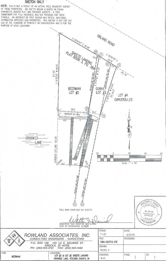
2. Piers shall not extend any further than 10 feet beyond adjacent piers.
3. The Petitioner and the Third Party Respondent grant permission for boats to moor at the Gorney pier 5 feet beyond riparian zone boundaries.
Beerman Summary Judgment, Item 2 Exhibit 1/Gorney Response Exhibit G. (Hereafter Exhibit 4 of the Mediation Agreement is referred to individually as “Exhibit 4” while the Mediation Agreement as a whole is referred to as “the Mediation Agreement”.)
43. Following the Gorneys initiation of the instant proceeding, Beerman, commissioned a survey by Rowland Associates, Inc. that was completed on August 24, 2015. Beerman Summary Judgment, Item 2 Exhibit 2. (Hereafter the survey will be referred to as “the Rowland Survey”).
44. Beerman maintains that the Gorneys have not placed their pier in a manner consistent with Exhibit 4 and alleges that the Gorneys’ pier encroaches into Beerman’s riparian zone. Beerman Summary Judgment, Item 2.
45. Contrary to Beerman’s allegation on summary judgment, Mark Gorney argues the Rowland Survey’s determination that the Gorneys’ pier encroaches into Beerman’s riparian zone results from Rowland Associates, Inc.’s belief that the Gorneys’ pier is five feet in width, when the Gorneys’ pier is actually only four feet in width. Gorney Response, Mark Gorney Affidavit; and Gorney Response Exhibit A/Beerman Summary Judgement Item 1, Gorneys’ Complaint.
46. The Gorneys also espouse the position that Beerman has not placed her pier in a manner consistent with Exhibit 4. Id.
47. The Gorneys rely upon photographic evidence in support of this allegation. Gorney Response Exhibit H. The Gorneys’ evidence does not include a survey.
48. Beerman maintains that the Gorneys’ evidence is insufficient to support the Gorneys’ position that Beerman’s pier “extends directly straight out and perpendicular to Beerman’s cement sidewalk from the cottage to the shoreline” instead of being placed consistent with Exhibit 4. Beerman Reply.
49. Exhibit 4 is reproduced here. Gorney Response Exhibit E/Beerman Summary Judgment Item 2 Exhibit 2.
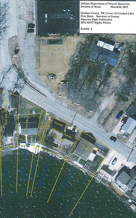
50. Exhibit 4 identifies the Gorneys’ and Beerman’s pier locations by blue rectangles that are five feet in width.
51. Exhibit 4 clearly reveals that under the Mediation Agreement both of the Gorneys’ riparian zone boundary lines extend lakeward at a slight eastward angle from the point at which the Gorney Property’s onshore boundary lines intersect the shoreline.
52. The Gorneys’ west riparian zone boundary is one in the same with Beerman’s east riparian zone boundary.
53. It is also clear from Exhibit 4 that Beerman’s west riparian zone boundary line is established by extending Beerman’s onshore boundary line straight lakeward.
54. According to Exhibit 4 the Gorneys’ pier is required to extend from essentially the center of their 15 foot length of shoreline at such an angle as to remain centered within the riparian zone to the lakeward terminus.
55. As depicted in Exhibit 4, the distance between Beerman’s pier and her western riparian zone boundary is greater at the shoreline than it is at the lakeward end of the pier. From this fact it is certain that under the terms of the Mediation Agreement Beerman’s pier is required to angle west as it extends lakeward from the shoreline.
56. In Exhibit 4 Beerman’s pier, at the shoreline, is depicted as being located near the center of the Beerman Property’s 38 feet of shoreline but offset slightly to the west of the sidewalk existing on the Beerman Property.
57. A review of Gorneys’ photographic evidence supports Beerman’s position that the photographs are taken from various angles such that they cannot be relied upon to establish with certainty the position of Beerman’s pier on the shoreline or angle as it extends lakeward from the shoreline. Gorney Response Exhibit H.
58. The Rowland survey is reproduced here.
59. The riparian zone boundary lines for both the east and west sides of the Gorney Property, shared on the west with the Beerman Property and on the east with the Christoules Property, are identified as “Riparian Line Per DNR” on the Rowland Survey.
60. Beerman’s western riparian zone boundary line is identified on the Rowland Survey as “Extended Lot Line”, which is also consistent with Exhibit 4.
[VOLUME 14, PAGE 162]
61. There is no evidence in the record contesting the location of the riparian zone boundaries as established in the Rowland Survey.
62. The Rowland Survey establishes the width of the Gorneys’ pier as “3.5’”. Consequently, the encroachment reflected on the Rowland Survey did not result from a mistaken belief that the Gorneys’ pier is five feet in width as Mark Gorney proposed. The Rowland Survey establishes that the Gorneys’ pier, at its lakeward end does encroach into Beerman’s riparian zone.
63. The Rowland Survey does not identify Beerman’s sidewalk but a comparison of the Rowland Survey and Exhibit 4 indicates that Beerman’s pier is appropriately located on the shoreline. According to the Rowland Survey, Beerman’s pier is located on the shoreline 17 feet west of her east riparian zone boundary, shared with the Gorneys, and 16.5 feet east of Beerman’s west riparian zone boundary. On Exhibit 4, Beerman’s shoreline measures 14/16th inch, or approximately 37.38 feet in length, with the center of the pier being located at approximately the 7/16th inch mark, or nearly the center of Beerman’s shoreline. [3]
64. According to the scale of the Rowland Survey, it is determined that both Beerman’s pier and the Gorneys’ pier extend 60 feet lakeward from the shoreline.
65. The Rowland Survey does not provide distances in such a way as to identify the exact location of the Gorneys’ pier on the shoreline. However, on the Rowland Survey the Gorney Property’s shoreline is identified as being 15 feet long. Without calculating estimated distances, the Gorneys’ shoreline, as depicted on Exhibit 4, measures slightly less than 3/8th inch, with the west side of the Gorney pier, identified on the Rowland Survey as “Gorney Dock”, being located approximately 1/8th inch from the Gorneys’ west riparian zone boundary and the east side of the Gorney pier being located approximately 1/8th inch from the Gorneys’ east riparian zone boundary. Consideration of both the Rowland Survey and Exhibit 4 allows the reasonable conclusion that the Gorneys’ pier is located appropriately near the center of the Gorney Property’s shoreline consistent with the requirements of the Mediation Agreement.
66. At the lakeward end, the west side of Beerman’s pier is 15.2 feet east of her western riparian zone boundary and 11.35[4] feet west of her east riparian zone boundary that is shared with the Gorneys. This is inconsistent with Exhibit 4. The Mediation Agreement requires the lakeward end of Beerman’s pier to be a greater distance from her east riparian zone boundary, shared with the Gorneys, and a lesser distance from her west riparian zone boundary. Beerman Summary Judgment Item 2, Exhibit 2.
67. The Gorneys’ allegation that Beerman’s failure to relocate her pier interferes with the use of their riparian zone is not refuted by Beerman.
68. By comparing the Rowland Survey with Exhibit 4, two factual conclusions are reached. Beerman Summary Judgment Item 2/Gorney Response Exhibit E.
a. The Gorneys’ pier location and angle of placement, as identified by the Rowland Survey, is not consistent with the Mediation Agreement. The Gorneys’ pier angles too sharply toward their west riparian zone boundary, which is shared with Beerman, causing approximately eight to 10 feet of the Gorneys’ pier at the lakeward end to encroach into Beerman’s riparian zone by approximately 1.25 feet at the lakeward end of the pier.
b. Beerman’s pier, as identified in the Rowland Survey, is not angled in a manner consistent with the Mediation Agreement. Exhibit 4 allows Beerman’s pier to extend lakeward at an angle towards the west within a five foot width of space having a western-most point located approximately 11 feet[5] east of Beerman’s west riparian zone boundary.
Conclusions of Law
69. It is recognized that under Indiana Code § 14-26-2-23(f), “a party to [a] dispute may seek enforcement of [a] determination (of the Commission) in a civil proceeding.” It is further recognized that an agreement at issue in this proceeding was reached between the parties through the Beerman Case. However, the agreement reached by the parties through the Beerman Case resulted in a dismissal of that proceeding such that the Commission issued no determination in that matter that might be enforced as contemplated by Ind. Code § 14-26-2-23.
70. The validity and effectiveness of the Mediation Agreement executed through the Beerman Case is not disputed. Beerman Summary Judgment, Item 3; Gorneys’ correspondence initiating this proceeding; Gorney Response, Mark Gorney Affidavit. It is concluded that the terms of the Mediation Agreement are enforceable and this proceeding addresses a continuing riparian rights dispute between the parties in the implementation of that Mediation Agreement respecting the Gorneys’ and Beerman’s riparian zone boundaries and the locations and angles of their piers.
71. This order shall not be construed as interpreting or otherwise impacting the Mediation Agreement except as it pertains to identifying the riparian zones and the locations and angles of the Gorneys’ and Beerman’s piers.
72. Except for classes of activities exempted from licensing under the authority of Indiana Code § 14-26-2-23(e)(2)(B), a person is prohibited from placing a temporary structure “over, along, or lakeward of the shoreline…of a public freshwater lake” unless the person first obtains a permit to do so. Indiana Code § 14-26-2-23(a).
73. The Commission authorized the placement of temporary structures without need for the person to obtain an individual written license, as follows:
(b) In order for a temporary structure to qualify, the structure must satisfy each of the following:
(1) Be easily removable.
(2) Not infringe on the access of an adjacent landowner to the public freshwater lake.
(3) Not unduly restrict navigation.
(4) Not be unusually wide or long relative to similar structures within the vicinity on the same public freshwater lake.
(5) Not extend more than one hundred fifty (150) feet from the shoreline or water line.
(6) If a pier, not extend over water that is continuously more than six (6) feet deep to a distance of one hundred fifty (150) feet from the shoreline or water line.
(7) Not be a marina.
(8) Not be a group pier.
(9) Be placed by a riparian owner or with the written approval of a riparian owner.
312 IAC 11-3-1.
74. A “temporary structure” includes:
A pier that:
(A) is supported by auger poles or other poles that do not exceed three and one-half (3 ½) inches in diameter and rest on the lake bed; and
(B) is not mounted in or comprised of concrete or cement.
312 IAC 11-2-25.
75. A pier placed in such a manner as to “infringe on the access of an adjacent landowner to the public freshwater lake” will no longer qualify for placement and maintenance within a public freshwater lake without an individual written license. See 312 IAC 11-3-1(b)(2).
76. As relevant here a riparian owner is the owner of land abutting the shoreline of a public freshwater lake. 312 IAC 11-2-19.
77. The evidence provided by the parties establishes that this proceeding is to address temporary structures placed and maintained along the shoreline of Crooked Lake by riparian owners.
78. In accordance with Indiana Code § 14-26-2-23(e)(2)(B), the Commission adopted 312 IAC 11-3-2, which provides that “A person may seek administrative review of the placement or maintenance of a structure…” placed under 312 IAC 11-3-1.
79. Beerman maintains, and the evidence establishes, that the Gorneys’ pier encroaches into her riparian zone.
80. The Gorneys maintain, and the evidence establishes, that Beerman has not placed her pier in a manner consistent with the Mediation Agreement and as a result interferes with their use of their riparian zone.
81. In light of the factual conclusion that the Gorneys’ pier infringes upon Beerman’s riparian zone and the factual conclusion that Beerman’s pier infringes upon the Gorneys’ use of their riparian zone, neither the Gorneys’ nor the Beerman’s piers presently qualify for placement under a general license. 312 IAC 11-3-1(b)(2).
82. For the Gorneys and Beerman to continue placing and maintaining their piers lakeward of the shoreline of Crooked Lake under the general license established by 312 IAC 11-3-1, they shall comply with the requirements of this order.
83. In addressing this dispute between the Gorneys and Beerman it is the primary responsibility of the Commission to address the riparian rights dispute in accordance with Indiana Code 14-26-2-23 and 312 IAC 11-3-1; however, in this instance it is determined that the parties’ Mediation Agreement is consistent with Commission precedent and for that reason the Commission also strives to give effect to that Mediation Agreement.
84. To the extent this order is inconsistent with any parties’ interpretation of the Mediation Agreement, this order shall control.
Final Order
85. The Gorneys’ and Beerman’s riparian zone boundaries are determined as set forth in the Rowland Survey.
86. The Rowland Survey indicates the Gorney Property shoreline is 15 feet in width and the width of the riparian zone at the terminal end of the Gorneys’ pier is 11.25[6] feet in width. Consistent with Exhibit 4’s requirement that the pier placement shall occur within a five foot width of space, the Gorneys’ pier shall not exceed five feet in width. The Gorneys shall make the best effort possible to locate their pier:
a. With the east side of the pier located at least five feet west of their east riparian zone boundary at the shoreline and at least three feet west of their east riparian zone boundary at the lakeward end based upon the existing 60 foot long pier; and
b. With the west side of the pier located at least five feet east of their west riparian zone boundary at the shoreline and at least three feet east of their west riparian zone boundary at the lakeward end based upon the existing 60 foot long pier.
87. The Rowland Survey indicates Beerman’s Property shoreline is 38 feet in width and the width of the riparian zone at the terminal end of Beerman’s pier is 29.45 feet in width. Consistent with Exhibit 4’s requirement that the pier placement shall occur within a five foot width of space, Beerman’s pier shall not exceed five feet in width. Beerman shall make the best effort possible to locate her pier:
a. With the east side of the pier located at least 16.5 feet west of her east riparian zone boundary at the shoreline and at least 13 feet[7] west of her east riparian zone boundary at the lakeward end based upon the existing 60 foot long pier; and
b. With the west side of the pier located at least 16.5 feet east of her west riparian zone boundary at the shoreline and at least 11 feet[8] east of her west riparian zone boundary at the lakeward end based upon the existing 60 foot long pier.
88. Upon proper recordation with the Recorder of Kosciusko County the foregoing order shall inure to the benefit of the heirs and assigns of the parties who are also bound by these terms.