CADDNAR
[CITE: Xanders v. Nixon Trust, 14 CADDNAR 33 (2015)]
[VOLUME 14, PAGE 33]
Cause #: 14-082W
Caption: Xanders v. Nixon Trust
Administrative Law Judge: Jensen
Attorneys: Snyder (Xanders); Birch (Nixon); Schrumpf, S. (Schrumpfs); Grow (DNR); pro se (Kozak Trust)
Date: August 31, 2015
[Editor’s Note: Final Order follows the Findings of Fact and Conclusions of Law.]
FINDINGS OF FACT AND CONCLUSIONS OF LAW
Procedural Background and Jurisdiction
1. George L. and Ann L. Xanders (“the Xanders”) filed correspondence with the Natural Resources Commission (“the Commission”) on June 3, 2014 seeking to “reach a mutually agreeable riparian agreement between 4 property holders, which allows for mooring of two boats.” Within the request, the Xanders identified the John R. Nixon Revocable Trust (“the Nixon Trust”), the Michael H. Kozak Trust (“the Kozak Trust”), and Stanley E. and Leona M. Schrumpf (“the Schrumpfs”) as the other three property owners necessary to just adjudication. The correspondence is characterized as a request to resolve a dispute amongst “persons with competing interests” as to riparian rights as specified at Indiana Code § 14-26-2-23(e)(3).
2. The Commission possesses jurisdiction over the subject matter and the parties to this proceeding and serves as the ultimate authority pursuant to 312 IAC 3-1-2.
3. The Xanders indicated willingness to erect a new pier, in which case they requested “approval to have the property holder to the north (Nixon Trust) move existing pier, boats, and personal watercraft out of the Xanders riparian zone.” Further the Xanders offered flexibility to share pier space on an existing pier if necessary.
4. The parties to this proceeding maintain a proprietary interest in properties located within Addmore Park, Xander’s and Snaveley’s 1st Addition (“Addmore Park”) that front on Syracuse Lake located in Kosciusko County.
5. Syracuse Lake is a “public freshwater lake” within the meaning of Indiana Code § 14-26-2-3. Indiana Code § 14-26-2-24 and Natural Resources Commission, Information Bulletin # 61 (Fourth Amendment) “Listing of Public Freshwater Lakes”, October 1, 2014.
6. An initial prehearing conference was conducted by teleconference on July 1, 2014. During the prehearing conference the parties clarified that the Schrumpfs own property that does not front on Syracuse Lake and their interest in this proceeding results from an easement granting a non-exclusive right to use the Xanders’ property. Also during the initial prehearing conference it became clear that additional property owners within Addmore Park may believe they possess the authority to exercise riparian rights through use of the Xanders’ property.
7. The Department of Natural Resources (“the Department”) filed its petition to intervene in the instant proceeding on September 8, 2014, which was granted in an order issued on September 10, 2014.
8. The administrative law judge observed that “a complete and enduring determination of riparian rights in this proceeding would require that all persons who may claim riparian rights through an easement associated with the Xanders’ property be given an opportunity to be heard through this proceeding.” Pursuant to the authority of 312 IAC 11-3-2(b), the owners of ten additional properties identified by the Xanders were joined and provided notice of a scheduled supplemental prehearing conference. Report of Telephone Prehearing Conference, July 8, 2014. The owners joined and affected properties are identified as follows:
a. Paul D. & Marlene K. Pollock, 13494 N. Eastshore Drive, Syracuse, Indiana;
b. Olen W. & Lucy J. Fry, 13490 Eastshore Drive, Syracuse, Indiana;
c. Rickey & Tammy S. Terry, 13474 N. Eastshore Drive, Syracuse, Indiana;
d. Daryl R. & Peggy L. Daniels, 13434 N. Eastshore Drive, Syracuse, Indiana;
e. Katherine Reum, 13408 N. Eastshore Drive, Syracuse, Indiana;
f. Thomas Jerome & Marcia Diane Xanders, 1104 S. Oakwood Drive, Syracuse, Indiana
g. Scott J. Werling; 13390 N. Eastshore Drive. Syracuse, Indiana;
h. Susan J. Kitson, Meredith Westerback, Molly Jobin & Dorothy Kitson, 13326 N. Eastshore Drive, Syracuse, Indiana;
i. Donald Eugene & Sandra C. Ritter, 13312 N. Eastshore Drive, Syracuse, Indiana; and,
j. Larry D. & Nancy D. Gadson and Christopher M. Adams, Jtwrs, 13314 N. Eastshore Drive, Syracuse, Indiana.
9. With the exception of Scott J. Werling, the parties joined on July 8, 2014 failed to appear for the scheduled supplemental prehearing conference. With respect to those parties who failed to appear a notice of proposed default was issued on August 15, 2014 allowing 10 days to provide notice justifying their failure to appear. Only Susan J. Kitson, on behalf of herself, Meredith Westerback, Molly Jobin & Dorothy Kitson, offered any explanation for the failure to appear.
10. On September 4, 2014, a final order of default was issued pursuant to Indiana Code § 4-21.5-3-24 and 312 IAC 3-1-9, against each of the joined parties except individual property owner, Scott J. Werling, and joint property owners, Susan J. Kitson, Meredith Westerback, Molly Jobin & Dorothy Kitson.
11. On December 3, 2014 an administrative hearing was scheduled to commence on March 26, 2015.
12. After having failed to appear for two subsequent status conferences, a second notice of proposed default was issued to Scott J. Werling, individually, and to Susan J. Kitson, Meredith Westerback, Molly Jobin & Dorothy Kitson, jointly, on March 12, 2015. These parties were again provided 10 days to offer justification for the failures to appear or participate. Scott J. Werling filed no response. Susan J. Kitson (“Kitson”) filed a response noting that she had been unexpectedly required to work on the occasion of the most recent status conference. Kitson offered no explanation for their failure to contact the Commission’s Division of Hearings to advise of her situation until after she received the second notice of proposed default. In the response, Kitson also provided notice that she would be unable to attend the scheduled administrative hearing due to a previously scheduled vacation for which she had made reservations in November 2014. Notably, Kitson’s travel plans were made before the administrative hearing was scheduled but following receipt of notice of the scheduled administrative hearing Kitson failed to seek a continuance or otherwise notify the Commission’s Division of Hearings of her scheduling conflict.
13. A final order of default with respect to Scott J. Werling and to Susan J. Kitson, Meredith Westerback, Molly Jobin & Dorothy Kitson, was orally entered before commencing the administrative hearing on March 26, 2015 and was formalized by written order issued March 31, 2015.
14. The final orders of default issued on September 4, 2014 and March 31, 2015, offered notification, as required by 312 IAC 3-1-9, that a “person who wishes to seek judicial review must file a petition in an appropriate court within 30 days of the order and must otherwise comply with IC 4-21.5-5.” The Commission received no notification of the filing of a petition for judicial review as would be required by IC § 4-21.5-5-7(b) and 312 IAC § 3-1-18. The Kozak Trust appeared by Trustee, Michael H. Kozak.
15. The administrative hearing was conducted on March 26, 2015, as scheduled. The Xanders appeared by counsel, Stephen R. Snyder, and the Nixon Trust appeared by counsel, Jack C. Birch. The Schrumpfs appeared by counsel, Stephen E. Schrumpf, and the Department appeared by counsel, Joy M. Grow.
16. At the conclusion of the administrative hearing the parties sought the opportunity to file post hearing briefs and following the grant of an extension of time the briefs were filed by each party except the Kozak Trust.
[VOLUME 14, PAGE 34]
FINDINGS OF FACT[1]
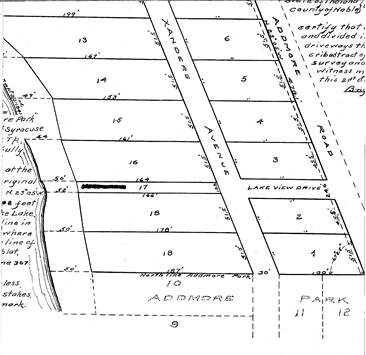
17. Addmore Park was platted on August 22, 1941 by George L. Xanders’ grandfather. As platted, Addmore Park consisted of Lots 1 – 9, which were generally bounded on the east by Addmore Road and on the west by Xanders Avenue and Lots 10 – 18, which were located between the shoreline of Syracuse Lake on the west and Xanders Avenue on the east. Exhibit A.
18. As platted, Xanders Avenue, which runs in a general north-south direction, essentially bisected Addmore Park with Lots 1 – 9 located to the east and Lots 10 – 18 situated to the west and along the shoreline of Syracuse Lake. The following excerpt of Exhibit A provides visual clarity of Addmore Park in the vicinity of Lots 16, 17, 18, and 19, which are at issue here.
19. The record is not clear as to the exact date Xanders Avenue was vacated but as early as April 8, 1971 there appears reference to the “vacated street east of Lot 17” and more current property records refer to the “vacated Xanders Avenue”. Exhibits B & H. Property records for each of the parties, all of whom own Lots both to the east and to the west of the platted Xanders Avenue reflect ownership of a portion of a vacated street. Exhibits 2, 4, 5, 6. The reasonable conclusion reached is that Xanders Avenue was, at a time prior to April 8, 1971, vacated and the portions were attributed to the owners whose property lay adjacent.
20. The Addmore Park plat also depicts the existence of Lakeview Drive, a 24.6 foot wide drive extending in an east – west direction, situated immediately east of the portion of vacated Xanders Avenue lying east of Lot 17 and extending to Addmore Road. The Xanders’ deed and property records reveal that Lakeview Drive was also vacated. Exhibits 2, F, G, H & I
21. The Xanders are the owners of “Lot Numbered Seventeen (17) in the Plat of Addmore Park, Xander’s and Snavely’s Addition, Syracuse Lake, as recorded in Plat Book 2, page 169A in the Office of the Recorder of Kosciusko County, Indiana. ALSO, that portion of vacated Xanders Avenue lying adjacent to Lot 17 above and that portion of vacated Lakeview Drive lying between vacated Xanders Avenue and Addmore Road and being east of Lot 17 above.” Exhibit 1[2].
22. The Xanders only access to Syracuse Lake is through the use of Lot 17. Id.
23. Based upon a survey prepared by Walker and Associates dated June 14, 2013, the Xanders’ property includes 12 feet of shoreline on Syracuse Lake. Exhibit 3.
24. The Walker & Associates survey, along with a review of current property records, reveals that Addmore Road is one in the same with what is currently known as Eastshore Drive. Exhibits A, 2, 3, 4, 6 & 7.
25. The north boundary of the Xanders’ property is shared with the southern boundary of Lots 3 and 16 as well as the conforming vacated portion of Xanders Avenue in Addmore Park, which is owned by the Nixon Trust. Exhibit 5. While the evidence does not include a survey of Lot 16’s shoreline it may be reasonably concluded that the Lot includes approximately 50 feet of shoreline. Testimony of Lynn Balkenbush, Exhibit A.
26. A parcel including Lots 2 and 18 as well as the northern one-half of Lots 1 and 19 along with the corresponding vacated portions of Xanders Avenue in Addmore Park is owned by the Kozak Trust. Exhibit 6. This property shares its northern boundary with the Xanders’ south property boundary. Again, there is no direct testimony and no survey in evidence establishing the length of shoreline possessed by the Kozak Trust but the plat of Addmore Park indicates that Lots 18 and 19 each have 50 feet of shoreline so it may be reasonably concluded that the Kozak Trust holds fee title to approximately 75 feet of shoreline on Syracuse Lake. Exhibit A.
27. Situated to the west and located on the opposite side of Eastshore Drive from Addmore Park is Wildwood Park, Xanders and Snavely First Addition to Bonar Lake (Wildwood Park). Exhibit 7.
28. In 1986, George L. Xanders’ father conveyed title to certain parcels of property as well as easement interests in additional properties located in Wildwood Park and Addmore Park to the Schrumpfs. As is relevant to this proceeding is the conveyance of a non-exclusive easement over Lot 17 in Addmore Park, which is expressly stated as follows:
Also, Grantor hereby grants to Grantees, their successors and assigns, a non-exclusive easement to construct and erect a pier on Lot 17 in Xanders and Snavely First Addition to Addmore Park for access to Syracuse Lake, together with the right to pass on foot over Lot 17 to gain access to use, maintain and repair the pier.
Until such time as the Grantor conveys out Lots 3, 4, 5, 6, and 21 in Wildwood Park, Xanders and Snavely First Addition to Bonar Lake, the Grantee shall bear the full expense of the construction, erection, maintenance, and repair of the pier. In the event Grantor conveys the above described easement rights to the owner or owners of Lots 3, 4, 5, 6, and 21, each owner, including Grantee, shall share proportionally with the other owners the expense of construction, erection, removal, maintenance and repair of the pier.
Grantor reserves unto himself and his invitees, for his natural life, the right to use the pier as access to Syracuse Lake.
This and subsequent grants of easement shall run with the land and shall be binding on and shall inure to the benefit of the parties hereto, their heirs, successors and assigns.
Exhibits 7 & 8
[VOLUME 14, PAGE 35]
29. Additional easement rights were not conveyed in conjunction with the conveyance of Lots 3, 4, 5, 6, and 21 in Wildwood Park. Testimony of George L. Xanders.
30. It is the belief of the Xanders that the easement conveyed to the Schrumpfs grants only the right to construct a pier for accessing Syracuse Lake but does not carry with it the right to moor a boat. Testimony of George L. Xanders.
31. Use of the properties now owned by the Xanders was reserved to George L. Xanders’ father until his death in 2008. For that reason the Xanders have made minimal use of the properties they now. Although they have made occasional use of the cottage located on the off-lake lots since 2008, the Xanders use of Lot 17 has continued to be limited. Testimony of George L. Xanders.
32. There has never been a pier extended from Lot 17 Addmore Park. Testimony of Lynn Balkenbush and George L. Xanders.
33. The owners of the Lot 16 commissioned the construction of the seawall existing along the shoreline of Lot 17 sometime before 1985. The circumstance under which the seawall was constructed was not provided in the evidence. Id. and Exhibit M.
34. The Xanders, who also own property in Wildwood Park, have entered into a contract for the mowing of grass on Lot 17 but that grass never needs mowed. Testimony of George Xanders. The evidence indicates that the owner of Lot 16, the Nixon Trust, has voluntarily mowed the grass on Lot 17. Testimony of Lynn Balkenbush.
35. Since the mid-1960s the Nixon Trust has maintained a pier in the same location extending from the shoreline of Lot 16 at or within very close proximity to the shared boundary line with the Xanders’ Lot 17. Id. & Exhibits K through O.
36. The evidence established that the Nixon Trust has always moored a sailboat, a ski boat and two jet skis on the north side of their pier reserving the space on the south side of the Nixon Trust pier as temporary boat mooring for friends and guests. The Nixon Trust also maintains a water trampoline that is situated “straight out from our pier”. Testimony of Lynn Balkenbush. The pier location accommodates the use of the waters directly lakeward of Lot 16 for swimming and other water recreation. Testimony of Lynn Balkenbush
37. Historic use of the south side by friends and guests of the Nixon Trust has required use of the waters lakeward of Lot 17. Id. While the Nixon Trust has never attached a pier to the shoreline associated with Lot 17, the Nixon Trust has, since the late 1950’s, used the waters lakeward of Lot 17 as their own. Id.
38. Lynn Balkenbush (“Balkenbush”) expressed that the extension of a pier from Lot 17 would eliminate the Nixon Trust’s available space for friends and guests to temporarily moor boats and “it would impact us greatly because of all the different toys we have had since…forever… since the ‘60s.” Balkenbush added, “It completely minimizes our play space.”
39. Balkenbush testified to her belief that the extension of a pier from Lot 17 will obligate the Nixon Trust to move its pier to the north which would decrease watercraft mooring space to such an extent that the Nixon Trust would be required to interfere with its neighbor to the north. Testimony of Balkenbush
40. Balkenbush also testified that she has safety related concerns with the installation of a pier and boat lift on Lot 17. She expressed that “on windy days…we have issues with the Kozak’s pier and we have issues, at times, with Claypeck’s[3] pier, and they are way further than this, on stormy days. I fear for the kids’ safety if they are that close, boats coming in and out…it just scares me, I think it’s very, very dangerous.”
41. The Xanders believe that as the owners of Lot 17 they are entitled to exercise all riparian rights associated with that ownership and expressed the intent to extend a pier and install a boat lift for the purpose of mooring a boat. Testimony of George L. Xanders. The intended pier and boat lift would have an overall width of 12 feet with the pier located on the south riparian zone boundary line and the boat lift located on the north side of the pier closest to the Nixon Trust’s Lot 16. Id. & Exhibit 9.
42. The Xanders intended pier and boat lift configuration would cause the Xanders to moor a boat in nearly the exact area where the friends and guests of the Nixon Trust have moored boats during visits since the 1960s.
43. Interesting is the fact that the Xanders use of this exact space creates such great concern for safety when the current use of the space by the friends and guests of the Nixon Trust is encouraged and desired.
44. In utilizing the riparian rights associated with Lot 17, the Xanders take the position that a 10 foot buffer should be maintained between the adjacent property owners’ respective piers and moored boats. In light of the significant differences in the lengths of shoreline owned by the Nixon Trust and the Kozak Trust as compared to the Xanders, the Xanders expressed the opinion that fairness requires the Nixon Trust and the Kozak Trust to be burdened with the full 10 feet of buffer in order to allow all three property owners to have reasonable use of their riparian rights. Testimony of George L. Xanders & Exhibit 9. This would require the Nixon Trust to relocate their pier to the north but the Kozak Trust pier would, possibly, not need to be moved in any way or may only need to be placed at a slightly different angle. Id & Exhibit 3.
45. Regardless of the placement of the Nixon Trust pier, the Nixon Trust’s use of the waters lakeward of the shoreline of Lot 17 for mooring the boats of friends and guests effectively prohibits the Xanders from exercising their riparian rights. Id. In fact, if the riparian zone established for Lot 17 is determined by extending onshore property lines lakeward, the Nixon Trust pier actually encroaches into the riparian zone of the Xanders’ Lot 17. Testimony of George L. Xanders & Exhibit 3.
46. In general the Department prefers “to have at least five feet between a pier and a property line on each lot and ideally it would be better to have 10 feet on each lot for a total of 20.” Testimony of James Hebenstreit. However, James Hebenstreit (Hebenstreit), who is an Assistant Director in the Department’s Division of Water with supervisory responsibility for permitting activity on public freshwater lakes, observed that through the general license applicable to the placement of temporary structures within public freshwater lakes any riparian owner may place a temporary pier that meets certain expressed criteria and acknowledged that frequently these piers are constructed with less than even five feet of buffer between the piers. Id. Hebenstreit clarified that there is no law or administrative rule expressly requiring any setback or buffer space between piers.
47. A difference of opinion exists between Rodney Neese (“Neese”), a professional land surveyor who is employed by the Department and Kevin Michael (“Michael”), a professional engineer and licensed professional land surveyor who is a co-owner of Walker & Associates, with respect to the appropriate method of establishing the riparian zones associated with Lots 16, 17, and 18. Testimony of Neese and Michael.
48. Michael was engaged by the Xanders to survey their onshore property, Lot 17 and the associated vacated avenue and drive, and also to provide an in-water survey of the most appropriate correlating riparian zone associated with that property considering the guidance set forth in “Riparian Zones Within Public Freshwater Lakes and Navigable Waters”, Information Bulletin #56 (Second Amendment) published in the Indiana Register on March 31, 2010, http://www.in.gov/legislative/iac/20100331-IR-312100175NRA.xml.pdf, (“IB #56”). Testimony of Michael.
49. Both Neese and Michael recognized IB #56 and expressed familiarity with the nonrule policy document. Both surveyors also exhibited experience in applying the principals described in IB #56. However, the two surveyors disagreed as to its application to the properties and riparian zones in this proceeding.
[VOLUME 14, PAGE 36]
50. Michael testified that his review of shoreline using GIS [geographic information system] data indicated that a curve in the shoreline of Syracuse Lake begins at a point to the south of Lots 16, 17 and 18 but those particular Lots, which are the Lots at issue here, are located on a section of Syracuse Lake’s shoreline that approximates a straight line. Michael further testified that a land based boundary line intersecting a shoreline within 10 – 15 degrees of 90 degrees is considered to be “approximately perpendicular” to the shoreline. From this premise, Michael reasoned that the onshore boundary lines of Lots 16, 17 and 18 are approximately perpendicular to the shoreline of Syracuse Lake and concluded that the Second Principle stated in IB #56 is appropriate for determining the riparian zone for Lot 17.
51. The Second Principle of IB #56 states:
Second principle: Where the shore approximates a straight line, and where the onshore property boundaries are approximately perpendicular to this line, the boundaries of riparian zones are determined by extending the onshore boundaries into the public waters.
Id. at pg. 3.
52. Neese expressed the opinion that an approximately perpendicular intersection of onshore boundary lines to a generally straight shoreline should deviate from 90 degrees by only 5 to 6 degrees. From this premise, Neese concluded that use of the Second Principal of IB #56 is not appropriate to the situation presented here. Neese, instead, determined that using either a combination of the Third Principal and the Fourth Principal or simply the use of the Fourth Principal had more appropriate applicability.
53. The Third Principle of IB #56 is applied in the following contexts:
Third Principle: Where the shore approximates a straight line, and where the onshore boundaries approach the shore at obtuse or acute angles, the boundaries of riparian zones are generally determined by extending a straight line at a perpendicular to the shore.
Id. at pg. 4.
54. The Fourth Principle of IB #56 is applicable as follows:
Fourth principle: Where the shore is irregular, and it is impossible to run lines at right angles to the shore for a just apportionment, the lines forming the boundaries between riparian zones should be run to divide the total navigable waterfront in proportion to the length of the shores of each owner taken according to the general trend of the shore. If the navigable waterfront borders a lake that is substantially round, or is a bay that is substantially round except for its connection to the main body of the public waters, the riparian zones may be formed by running lines from each owner's shore boundaries to the center of the lake or bay. If the navigable waterfront borders a long lake or other public waters that are not substantially round, the boundaries of the riparian zones may be formed by running a line through the center of the public waters, with deflected lines run from each owner's shore boundaries to intersect the centerline at perpendiculars.
Id. at pg. 6.
55. Neese prepared two different riparian zone distributions associated with a section of the shoreline of Syracuse Lake that includes shoreline owned by as many as seven property owners who are not parties to this proceeding and who are also not one of the parties previously defaulted. Exhibit J[4]. The first distribution applies a combination of the Third and Fourth Principles, Exhibit J(1), while the second applies only the Fourth Principle, Exhibit J(2). Both of the riparian zone distributions were overlaid upon Geographical Information System [GIS] aerial satellite maps. Exhibit J.
56. Neese acknowledged that the overlaid riparian zone distribution boundaries displayed on his diagrams are offset by approximately 10 feet north of the actual point at which the onshore property boundaries intersect with the shoreline as depicted on the satellite image. Testimony of Neese.
57. The error in Neese’s diagrams caused him to erroneously identify the Nixon Trust’s pier as being owned by the Xanders. Id. This error related to the erroneous location of riparian zone boundary lines as drawn in the diagrams it appears to extend from Lot 17. All of the remaining evidence clearly refutes this conclusion. Id. and Exhibits J(1) and J(2). The fact that Neese’s diagrams caused this conclusory error the remaining conclusions based upon Exhibit J are also questionable in the mind of the administrative law judge. For this reason the administrative law judge expressed that the weight given to Exhibit J and testimony provided in reliance on Exhibit J, which was admitted over the objection of the Petitioners, for the reason that it provided demonstrative evidence of what riparian zones would look like if determined using the Third or Fourth Principle of IB #56. Otherwise, the administrative law judge reflected that the value of Exhibit J would be limited.
58. Neese concluded, based upon the points of intersection between the shoreline and onshore boundary lines, as depicted on Exhibits J(1) and J(2), that establishing riparian zone boundary lines by extending onshore boundary lines lakeward, as specified by the Second Principle, would cause nearly all of the piers depicted in the satellite image be outside the established riparian zones. Testimony of Neese. Neese’s conclusion appears to be reasonable until the intersection point between the onshore boundary lines and the shoreline depicted on Exhibits J(1) and J(2) are adjusted 10 feet south, as Neese acknowledged was necessary. After applying the necessary adjustment, Neese’s conclusion is not clearly supported. Exhibits J(1) and J(2).
59. With respect to the use of the Third Principle, IB #56 specifies that “Application of the Third Principle is most compelling where land owners in the vicinity have historically used a perpendicular line to divide their riparian zones.”
60. Each of the piers depicted on the satellite imagery appear to be situated to extend within riparian zones established by extending onshore property lines lakeward as opposed to exhibiting a history that riparian zones in the vicinity of Lots 16, 17, and 18 have been determined by using perpendicular lines extended lakeward. Exhibit J(1) and J(2). While the historic pier locations appear inconsistent with the application of the Third Principle of IB #56 they do appear to be consistent with the application of the Second Principle of IB #56 as recommended by Michael. Id.
61. Application of the Second Principle of IB #56 to Lot 17 establishes a riparian zone extending lakeward from the shoreline that remains 12 feet in width from the shoreline to the lakeward terminus regardless of the distance the riparian zone extends from the shoreline. Conversely, application of the Fourth Principle of IB #56, as alternatively proposed by Neese, which pro-rates the waters lakeward of the respective owners’ shoreline by the degree of shoreline owned by each, would establish a riparian zone for Lot 17 that is 12 feet in width at the shoreline gradually narrowing as the distance lakeward from the shoreline increases.
62. Neese was unable to provide the percentage of pro-ration he applied and was unable to state the width of the Xanders riparian zone at 125 feet lakeward of the shoreline. Exhibit J(2). The diagram produced by Neese to demonstrate the effect of pro-ration upon the riparian zones of Lots 16, 17 and 18 does not provide measurements or dimensions. Id. The evidence provided during the administrative hearing is insufficient to allow replication of Neese’s pro-ration of the riparian zones.
63. While Neese was unable to provide an exact width of Lot 16’s, 17’s, 18’s or 19’s riparian zone at 125 feet lakeward of the shoreline, he testified that the widths are only slightly less than the respective shoreline lengths. Testimony of Neese.
64. It is noted that establishing the riparian zone boundaries for Lot 17 will necessarily also establish the south riparian zone boundary associated with the Lot 16 and the north riparian zone boundary associated with Lot 18. Testimony of Neese and Michael, Exhibits 3 and J. Using the Second Principal of IB #56, as was done by Michael, impacts only those riparian zone boundaries.
65. Proper application of the Third Principle or Fourth Principle of IB #56 would also establish the north riparian boundary of Lot 16, the Nixon Trust’s riparian zone and the south boundary of Lot 18 and ½ of Lot 19, the Kozak Trust’s riparian zone, which would impact the riparian zones of property owners to the north of the Nixon Trust’s property and to the south of the Kozak Trust’s property, who are not parties to this proceeding and who are not parties to whom the previously issued final orders of default were addressed.
[VOLUME 14, PAGE 37]
CONCLUSIONS OF LAW
Effect of Final Orders of Default
66. The issuance of an order of default is governed by 312 IAC 3-1-9, which, in relevant part states as follows:
(e) After issuing an order of default, but before issuing a final order or disposition, the administrative law judge shall conduct any action necessary to complete the proceeding without the participation of the party in default and shall determine all issues in the adjudication, including those affecting the defaulting party. The administrative law judge may conduct proceedings under IC 4-21.5-3-23 to resolve any issue of fact.
…
(h) A final order entered under this section is made with prejudice unless otherwise specified in the order. A person may seek judicial review of the order as provided in IC 4-21.5-5.
67. Pursuant to 312 IAC 3-1-9, the administrative law judge acting as the ultimate authority on behalf of the Commission, may issue an order determinative of the rights and interests, if any, of a defaulted party without the involvement of that party. DNR v. Wildwood Shores Corp., and Earl Tidwell, 7 CADDNAR 217, (2000), Gross v. IDNR and Howard, 13 CADDNAR 283 (2014).
68. The only available evidence establishes that there was no conveyance of any easement granting authority to any person to use the riparian rights associated with Lot 17, except the 1986 conveyance made to the Schrumpfs by George L. Xanders’ father.
69. Any claims of right to use riparian rights contemporaneous to Lot 17 are concluded in favor of the Xanders and against each of the defaulted parties identified in Finding 8.
The Xanders’ Riparian Rights
70. Through the Lakes Preservation Act (“LPA”), Indiana Code §§ 14-26 et seq., the Department holds Indiana’s public freshwater lakes, including Syracuse Lake, in trust for the benefit of the public. However, it has been long recognized that the LPA “does not eliminate riparian rights” but establishes those rights as statutory rights that “must be balanced with the public’s rights.” Id. citing Zapfe v. Srbeny, 587 N.E.2d 177 (Ind. App. 1992), Bath v. Courts, 459 N.E.2d 72, (Ind. App. 1984) and Lake of the Woods v. Ralston, 748 N.E.2d 396 (Ind. App. 2001).
71. A riparian owner is an “owner of land, or the owner of an interest in land sufficient to establish the same legal standing as the owner of land, bound by a lake.” 312 IAC 11-2-19. “A person with fee simple ownership along a lake has riparian rights.” Sims, et al. v. Outlook Cove LLC, et al. 10 CADDNAR 258, 270 (2006).
72. The Xanders are riparian owners by virtue of their ownership of Lot 17 in Addmore Park.
73. Riparian rights are most commonly described consistent with the following:
The term “riparian rights” indicates a bundle of rights that turn on the physical relationship of a body of water to the abutting land. Riparian rights are special rights pertaining to the use of a waterway adjoining the owner’s property. Persons who enjoy riparian rights may access the waterway to swim, fish, and boat. The installation of a pier may be a reasonable use. Daisy Farm Limited Partnership v. Morrolf, 886 N.E.2d 604, 607 (Ind. App. 2008).
Meyers Subdivision POA v. DNR and Kranz, 12 CADDNAR 282, 283, (2011).
74. It is recognized that “the rights associated with riparian ownership generally include: (1) the right of access to navigable water; (2) the right to build a pier out to the line of navigability; (3) the right to accretions; and (4) the right to a reasonable use of the water for general purposes such as boating, domestic use, etc.” Parkison v. McCue, 831 N.E.2d 118, 128 (Ind. Ct. App. 2005) as cited in Lukis v. Ray, 888 N.E.2d 325, 330 - 331; Ind. Ct. App. 2008.
75. As relevant to this discussion, in 2000, the Indiana General Assembly directed the Commission as follows:
(e) The commission shall adopt rules under IC 4-22-2 to do the following:
…
(2) Provide objective standards for issuing permits under this section, including standards for the configuration of piers, boat stations, platforms, and similar structures. The standards:
…
(B) shall exempt any class of activities from licensing, including temporary structures, if the commission finds that the class is unlikely to pose more than a minimal potential for harm to the public rights described in section 5 of this chapter.
Indiana Code §14-26-2-23.
76. In compliance with Indiana Code § 14-26-2-23(e)(2)(B), the Commission adopted 312 IAC 11-3-1, which states:
Sec. 1. (a) The placement and maintenance of a:
(1) temporary structure;
(2) dry hydrant; or
(3) glacial stone reface;
is authorized without a written license issued by the department under IC 14-26-2 and this rule if the temporary structure, dry hydrant, or glacial stone reface qualifies under this section.
(b) In order for a temporary structure to qualify, the structure must satisfy each of the following:
(1) Be easily removable.
(2) Not infringe on the access of an adjacent landowner to the public freshwater lake.
(3) Not unduly restrict navigation.
(4) Not be unusually wide or long relative to similar structures within the vicinity on the same public freshwater lake.
(5) Not extend more than one hundred fifty (150) feet from the shoreline or water line.
(6) If a pier, not extend over water that is continuously more than six (6) feet deep to a distance of one hundred fifty (150) feet from the shoreline or water line.
(7) Not be a marina.
(8) Not be a group pier.
(9) Be placed by a riparian owner or with the written approval of a riparian owner.
77. A “temporary structure” is defined as follows:
Sec. 25. (a) "Temporary structure" means a structure that can be installed and removed from the waters of a public freshwater lake without using a crane, bulldozer, backhoe, or similar heavy or large machinery.
(b) Examples of a temporary structure include the following:
(1) A pier that:
(A) is supported by auger poles or other poles that do not exceed three and one-half (3½) inches in diameter and rest on the lake bed; and
(B) is not mounted in or comprised of concrete or cement.
(2) A boat shelter, boat lift, or boat hoist that:
(A) has a canvas top and sides;
(B) is supported by auger poles or other poles that do not exceed three and one-half (3½) inches in diameter;
(C) is not mounted in or comprised of concrete or cement;
(D) is designed to float or to rest upon the bed of the lake under its own weight if any structure to which it is attached
complies with this section; and
(E) is not wider than ten (10) feet nor longer than twenty (20) feet.
312 IAC 11-2-25.
[VOLUME 14, PAGE 38]
78. In combination, Indiana Code § 14-26-2-23(e)(2)(B) and 312 IAC 11-2-25 authorizes the Xanders to extend a qualifying pier into the waters of Syracuse Lake from Lot 17 without need for an individual permit.
79. Additionally, the Xanders are authorized as riparian owners to take other actions authorized by general license or to seek and receive an individual permit for activities on the waters of Syracuse Lake. See generally Indiana Code §§ 14-26.
80. The modest 12 foot width of Lot 17’s shoreline will necessarily create limitations on the Xanders’ exercise of their riparian rights. However, the modest width does not eliminate the Xanders’ ability to exercise their riparian rights or render unreasonable the exercise of those riparian rights to include the extension of a pier and mooring a boat at that pier. See Lawson v. Halliwill, 13 CADDNAR 146 (2013), allowing 10 feet of shoreline to be used by two families for placing a pier and mooring boats, and Havel & Stickelmeyer v. Fisher, et al., 11 CADDNAR 110 (2007), authorizing the extension of a pier from an easement consisting of only three feet of shoreline.
Establishment of Riparian Zone for the Xanders’ Lot 17
81. The Second, Third and Fourth Principles for establishing riparian zones as set forth in IB #56 were described in Nosek v. Stryker, 103 Wis. 2d 633, 309 N.W.2d 868 (Wis. 1981), which was recognized by the Indiana Court of Appeals in Bath v. Courts, 459 N.E.2d 72 (Ind. App. 1984).
82. In the 2008 Nosek decision, the Indiana Court of Appeals “emphasized that the [apportionment or pro-ration method] ‘is only to be applied when the irregularities or curvature of the shore are such that lines cannot be equitably drawn at right angles to the shore.’" Lukis at 331. The Fourth Principle in IB #56 echoes this concept stating that the pro-ration method should be used where “…it is impossible to run lines at right angles to the shore for a just apportionment…”
83. According to Neese the differences between establishing Lot 17’s riparian zone by pro-ration using the Fourth Principle, is only minimally different from the riparian zone as it would exist if established by running lines perpendicular to the shoreline from the point of intersection between onshore property boundaries and the shoreline as prescribed by the Third Principle. For this reason it is concluded that irregularities in the shoreline do not, in this case, prevent an equitable distribution by application of other means. Therefore, use of the Fourth Principle is not the most appropriate given the facts of this case.
84. Furthermore, the evidence supports a conclusion that the overall size of Lot 17’s riparian zone, if established by the Third Principle, will be only minimally different than the size of the zone if established by application of the Second Principle. The difference in the result between application of the Second Principle and the Third Principle is the angle at which the riparian zone boundary lines will extend lakeward.
85. Similar to the limitation expressed with respect to the use of the Fourth Principle, the Third Principle is not the most appropriate principle for application unless the historic pier placement in the vicinity reflects reliance upon the establishment of riparian zones by the extension of lines perpendicular to the points of intersection between onshore boundary lines and the shoreline. The aerial photographs used in the creation of Exhibit J(1) and J(2) reflect that eight of the nine piers displayed extend from the shoreline as if the riparian zones were determined by onshore boundary lines extended lakeward, as prescribed by the Second Principle.
86. The evidence available does not support the use of the Third Principle to establish the riparian zone for Lot 17.
87. Establishing the riparian zone for Lot 17 using the Second Principle of IB #56 is the most appropriate.
88. Furthermore, the establishment of the Xanders’ riparian zone through the application of the Second Principle set forth in IB #56, will not impact the Nixon Trust’s (Lot 16) north riparian zone boundary or the south riparian zone boundary of the Kozak Trust (Lot 18 and ½ of Lot 19) thereby avoiding unnecessary involvement of the owners of property abutting Syracuse Lake to the north of the Nixon Trust or to the south of the Kozak Trust.
89. The Department’s desire to impact as few riparian owners or holders of riparian interests in the vicinity of Lot 17 appears to be effectuated by application of the Second Principle of IB #56.
Exercise of Riparian Rights as Between the Xanders, the Nixon Trust and the Kozak Trust
90. As the riparian owners of Lot 17, which fronts on Syracuse Lake, the Xanders may exercise their riparian interests without interference by any other riparian owner.
91. While it is acknowledged that the Nixon Trust has maintained its pier in its present location since the 1950s and have routinely made use of the waters lakeward of Lot 17, “[f]irst in time first in right is not a viable factual or legal principle for determining the rights of riparian owners or those of the public on the open waters of public freshwater lakes.” Ray v. Blackburn and Lukis, et al., 10 CADDNAR 400, 412 (2006) citing Barbee Villa Condominium Owners Association v. Shrock, 10 CADDNAR 23, (2005).
92. “Clearly, the installation of a pier by a riparian owner is a reasonable use under IC 13-2-4-5, so long as it does not interfere with the use of the lake by others. One of the primary reasons for extending a pier any substantial distance into a lake is to permit boat-owners to moor and launch their boats in areas of navigable water. Thus, any extension of a pier beyond the point required for the mooring and launching of boats might be considered unreasonable.” Zapffe v. Srbeny, 587 NE 2d 177, 181, (Ind. Ct. App. 1991).
93. A riparian owner is the proprietor of only those riparian rights consequent to the owner’s fee title ownership of the shoreline and “the law ‘prohibits encroachments upon the riparian rights of another.’” Belcher & Belcher v. Yager-Rosales, 11 CADDNAR 79, 82, (2007) citing Bath v. Courts, 459 N.E.2d 72, 76 (Ind. Ct. App. 1984). Similarly, in a manner consistent with the placement of public freshwater lakes in trust for the benefit of the public “riparian right owners may build a pier within the extension of [their] shore boundaries only so far out as not to interfere with the use of the lake by others.” Id.
94. When moored to a pier, a boat requires the usage of a riparian zone similar to the usage of a pier to the point that the boat “essentially becomes an extension of the pier.” For this reason “[m]ooring a boat is an exercise of proprietary rights and would typically be unreasonable in the same locations where a pier would be unreasonable.” Roberts v. Beachview Properties, LLC, et al., 10 CADDNAR 125, 141, (2005)], citing Barbee Villa, supra.
95. Riparian owners are required “to adjust their conduct, watercraft use and placement to circumstances exigent at time of use.” Id. To this end, when a riparian owner’s maintenance of pier(s), boat lift(s), boat(s) or other watercraft; water recreation apparatus, or any other type of temporary structure cannot be maintained within the boundaries of the riparian owner’s riparian zone, the riparian owner’s maintenance of such item(s) or structure(s) will be disallowed. Belcher & Belcher, supra.
96. The Commission has routinely concluded that clear space between piers and moored boats is necessary to provide for safe navigation. IB #56, Havel, supra at 119, Roberts, supra at 166, Rufenbarger & Rufenbarger v. Blue, et al., 11 CADDNAR 185 (2007) and Sims, et al. v. Outlook Cove, LLC and Outlook Cove Homeowners Ass’n, 10 CADDNAR 258. 279, (2006).
97. Ideally, a total of 20 feet of clear space and minimally 10 feet of clear space is customary. Id. Again, the ideal situation would impose upon each riparian owner the responsibility to contribute one half of the total clear space required.
[VOLUME 14, PAGE 39]
98. However, dependent upon factual situations under consideration the amount of clear space and the responsibility of riparian owners to contribute to that clear space has varied significantly. In Sims, it was determined that the adjacent riparian owners one of whom owned 151 feet of shoreline and the other owned 817 feet of shoreline on opposing sides of a riparian boundary line were each required to maintain 10 feet of clear space for a total of 20 feet. However, in Rufenbarger, the competing interests of neighboring riparian owners one of whose property was burdened with an easement granting riparian rights to a group of as many as 17 additional individuals or entities, dictated that the open space be minimized to five feet on each side of the shared riparian zone boundary. See also, Walther, et al. v. Pier 343 Condominium Owners Assoc., 12 CADDNAR 12 (2009), which also provides a worthwhile discussion regarding the development of IB #56.
99. The Department has approved individual permits authorizing the installation and maintenance of piers within public freshwater lakes without requiring a full 20 feet (10 feet contributed by each riparian owner) of clear space. Skilbred, et al. v. Ward, et al., 13 CADDNAR 125 (2013), affirming the Department’s approval of permits to place piers while maintaining only five feet of clear space.
100. While the Commission’s decisions almost uniformly specify clear space requirements, such is not always the case. Recently the Commission did not specify any amount of clear space required to be maintained between piers and boats on three riparian zones the middle one of which was a drive containing 10 feet of shoreline upon which two property owners were authorized to place a pier and moor boats. Instead, the Commission stated, “The parties would typically achieve mutual benefit by placing their piers near the center of their shoreline for the respective riparian zones, but extending a pier slightly off-center from the Drive in one direction, with any boat moored in the opposite direction, may maximize safety and navigability.” Lawson v. Halliwill, 13 CADDNAR 146, 154, (2013).
101. Similarly, in an effort to facilitate the reasonable use of all parties’ riparian interests, the Commission has required a greater degree of contribution to clear space from one riparian owner than from another. In Lukis, supra, it was determined that “to improve navigational safety as well as provide for unimpeded ingress and egress for the benefit of adjacent riparian owners and the public as specified at 312 IAC 11-3-1(b)(2 & 3), Lukis shall remove the boatlift … from the east side of his temporary pier and is further restricted in his use of his riparian zone to the extent that any temporary structure or appendage to any temporary structure (including watercraft) shall not be placed or maintained closer to Lukis’ eastern property line extended than what is depicted in Exhibit II, page 1….”
102. The practical outcome in both Lukis and Lawson is that one riparian owner may be responsible for contributing a greater amount of clear space than other riparian owners. In Lukis, property owners having riparian areas determined by shoreline ownership of less than 30 feet were not restricted with respect to the placement of temporary structures within their riparian zones, whereas, Lukis, whose riparian zone related to 89 feet of owned shoreline was prohibited from placing any appendages to the side of his pier closest the neighbors with whom the dispute arose. In Lawson, the placement of a pier in the center of riparian zones correlating to greater expanse of shoreline logically provides a greater clear space than the centering of a pier on the smaller, 10 foot length of shoreline.
103. The only evidence citing safety concerns results from the testimony of Balkenbush on behalf of the Nixon Trust and this testimony, for the reasons previously stated appears to be somewhat exaggerated.
104. With respect to navigation, Balkenbush testified that, at times, on stormy days, she has had problems with the Kozak Trust’s pier and the Claypeck’s pier. The evidence indicates that these piers are situated at least 70 feet apart. Testimony indicating difficulty in navigation of watercraft to a pier within a 70 foot expanse of shoreline appears to be overstated.
The Schrumpfs Riparian Interests Pursuant to the 1986 Easement
105. The Schrumpfs, who do not hold title to property abutting Syracuse Lake, are not riparian owners with respect to Syracuse Lake.
106. The conclusion that the Schrumpfs are not riparian owners is not determinative of their right to exercise the riparian rights through the grant of the “non-exclusive easement to construct and erect a pier” from Lot 17 in Addmore Park. Klotz v. Horn, 558 N.E.2d 1096, 1097 (Ind. 1990).
107. General convention applicable to the interpretation of easements in this context of riparian rights is set forth in Parkison v. McCue, 831 N.E.2d 118, 128 (Ind. Ct. App. 2005), as follows:
Easements burdening land with riparian rights attached do not necessarily provide the easement holder use of these riparian rights. Brown v. Heidersbach, 172 Ind. App. 434, 441, 360 N.E.2d 614, 619-20 (1977). Instead, we first look to the express language of the easement. Klotz v. Horn, 558 N.E.2d 1096, 1097-98 (Ind. 1990). “An instrument creating an easement must be construed according to the intention of the parties, as ascertained from all facts and circumstances, and from an examination of all its material parts.” Brown, 172 Ind. App. at 441, 360 N.E.2d at 620. Courts may resort to extrinsic evidence to ascertain the intent of the grantors creating the easement only where the language establishing the easement is ambiguous. Gunderson v. Rondenelli, 677 N.E.2d 601, 603 (Ind.Ct.App. 1997) (citing Klotz, 558 N.E.2d at 1098). A deed is ambiguous if it is susceptible to more than one interpretation and reasonably intelligent persons would honestly differ as to its meaning. See Abbey Villas Dev. Corp. v. Site Contractors, Inc., 716 N.E.2d 91, 100 (Ind.Ct.App. 1999), trans. denied.”
108. The instrument creating the Schrumpfs’ easement involving Lot 17 provided the Schrumpfs the non-exclusive right to “construct and erect a pier on Lot 17…together with the right to pass on foot over Lot 17 to gain access to use, maintain and repair the pier.” Exhibits 7 & 8.
109. It has been concluded by the Commission on past occasions that an easement conveying the right to cross over property to access a public freshwater lake, without more, is ambiguous and therefore supports the consideration of parole evidence. Such is not the situation presented here.
110. In this instance the conveyance grants more than the authority for the Schrumpfs to access the lake, it grants the right to construct and use a pier.
111. Although the particular use allowed to be made of the pier is not expressly stated in the instrument of conveyance, the ability to construct and use a pier, without more, provides significant access to Syracuse Lake. A pier offers the safe and convenient passage over the seawall constructed by the Nixon Trust, which carries with it the means to more easily access the waters for swimming and wading or for launching small watercraft, such as kayaks or canoes. The ability to construct and use a pier provides a platform for fishing or otherwise enjoying the aesthetic qualities of the lake. Furthermore, “a person may navigate a watercraft within the riparian zone of another person and within the setback areas required by IB #56 for purposes of ingress and egress and the loading and unloading of passengers because a ‘temporary use of this nature does not unreasonably infringe on the riparian rights’ of another person.” Skilbred, et al. v. Spaw, et al., 13 CADDNAR 99 (2013), citing Barbee Villa Condominium Owners Assoc. v. Shrock, 10 CADDNAR 23, 27, (2005).
112. The ability to construct and use a pier, without mooring a boat, provides many accessibilities to Syracuse Lake with no greater burden on the riparian zone of Lot 17 than the width of the pier that is expressly authorized. The mooring of a boat requires usage of a riparian zone similar to the use made by a pier. Roberts, supra.
[VOLUME 14, PAGE 40]
113. In 2012, the Indiana Court of Appeals discussed the reciprocal relationship existing between an easement holder and the owners of land burdened with the easement.
It is well established that easements are limited to the purpose for which they are granted. The owner of an easement, known as the dominant estate, possesses all rights necessarily incident to the enjoyment of the easement. The owner of the property over which the easement passes, known as the servient estate, may use his property in any manner and for any purpose consistent with the enjoyment of the easement, and the dominant estate cannot interfere with the use. All rights necessarily incident to the enjoyment of the easement are possessed by the owner of the dominant estate, and it is the duty of the servient owner to permit the dominant owner to enjoy his easement without interference. The servient owner may not so use his land as to obstruct the easement or interfere with the enjoyment thereof by the owner of the dominant estate. Moreover, the owner of the dominant estate cannot subject the servient estate to extra burdens, any more than the holder of the servient estate can materially impair or unreasonably interfere with the use of the easement. Rehl v. Billetz, 963 N.E.2d 1 (Ind. App. 2012).
Skilbred, supra, Exhibit A.
114. To construe the instrument of conveyance to the Schrumpfs to include the ability to moor a boat greatly increases the burden upon Lot 17 in terms of the physical footprint upon Lot 17’s riparian zone. Such an interpretation is analogous to the position put forth by the holder of an easement across land granted expressly for ingress and egress who unsuccessfully argued that the easement also allowed for vehicular parking. Kwolek v. Swickard, 944 N.E.2d 564, (Ind. App. 2011).
115. The Schrumpfs rights under the easement are limited to those rights granted, which in this case includes the right to construct and use a pier for access to Syracuse Lake and to cross by foot over Lot 17 to reach the pier.
116. The Schrumpfs use of a pier extending from Lot 17 is limited as stated herein and does not include the right to moor a boat. The Schrumpfs must remember that their use is non-exclusive and thereby allows the contemporaneous exercise of riparian rights by the Xanders.
117. Similarly the Xanders, in exercising their riparian rights associated with Lot 17, must be ever mindful of their obligation to avoid interfering with the Schrumpfs granted easement rights.
118. Indiana Code § 14-26-2-23(e)(2)(A) authorizes the Commission to provide for common use of structures “to accommodate the interests of landowners having property rights abutting the public freshwater lake or rights to access the public freshwater lake…”
119. It is appropriate in this instance to avoid undue congestion of the shoreline of Syracuse Lake to require the Schrumpfs and the Xanders to exercise their respective rights through the use of a common pier.
FINAL ORDER
120. It is concluded that the following individuals, their heirs and assigns are without authority to use the riparian rights associated with Lot 17 Addmore Park presently owned by the Xanders:
a. Paul D. & Marlene K. Pollock, 13494 N. Eastshore Drive, Syracuse, Indiana;
b. Olen W. & Lucy J. Fry, 13490 Eastshore Drive, Syracuse, Indiana;
c. Rickey & Tammy S. Terry, 13474 N. Eastshore Drive, Syracuse, Indiana;
d. Daryl R. & Peggy L. Daniels, 13434 N. Eastshore Drive, Syracuse, Indiana;
e. Katherine Reum, 13408 N. Eastshore Drive, Syracuse, Indiana;
f. Thomas Jerome & Marcia Diane Xanders, 1104 S. Oakwood Drive, Syracuse, Indiana
g. Scott J. Werling; 13390 N. Eastshore Drive. Syracuse, Indiana;
h. Susan J. Kitson, Meredith Westerback, Molly Jobin & Dorothy Kitson, 13326 N. Eastshore Drive, Syracuse, Indiana;
i. Donald Eugene & Sandra C. Ritter, 13312 N. Eastshore Drive, Syracuse, Indiana; and,
j. Larry D. & Nancy D. Gadson and Christopher M. Adams, Jtwrs, 13314 N. Eastshore Drive, Syracuse, Indiana.[5]
121. The riparian zone for Lot 17 shall be established through application of the Second Principle set forth in IB #56, as set forth in the survey prepared by Walker & Associates and introduced into this record as Exhibit 3, which is attached and incorporated by reference.
122. The establishment of the riparian zone boundaries for Lot 17 also establishes the south riparian zone boundary of Lot 16 and the north riparian zone boundary of Lot 18 owned by the Nixon Trust and the Kozak Trust, respectively.
123. The Schrumpfs’ easement authorizes the use of a pier extended from Lot 17 for access to Syracuse Lake as discussed in this order. The easement does not authorize the Schrumpfs to moor a boat with the riparian zone associated with Lot 17.
124. The Xanders are authorized to extend a pier from the shoreline of Lot 17 and moor boat(s) provided such activity occurs in a manner consistent with applicable law and the specifications of this order.
125. The Schrumpfs and the Xanders must exercise their respective rights through the use of a common pier.
126. The Xanders shall maintain one foot (1’) of clear space inside each boundary line of the riparian zone established for Lot 17.
127. The Kozak Trust shall observe nine feet (9’) of clear space to the south of the shared riparian zone boundary established between Lots 17 and 18 and the Nixon Trust shall observe nine feet (9’) of clear space to the north of the shared riparian zone boundary established between Lots 16 and 17.
128. The clear space designated herein shall not be used for any type of boat mooring. However, such space may be traversed for the purpose of temporary docking associated with the loading and unloading of passengers or other similar short term use.
129. The Kozak Trust and the Nixon Trust shall relocate temporary structures and moored boats or other appendages as necessary to comply with this order.
130. It is understood that full compliance with this order may necessitate the commissioning of a surveyor to identify the exact locations for the appropriate placement of temporary structures.
131. The Final Order inures to the benefit of the heirs and assigns of the parties who are also bound by its terms.
[1] If any Finding of Fact, as stated herein, should have been designated a Conclusion of Law or if any Conclusion of Law, as stated herein, should have been designated a Finding of Fact, such is hereby adopted.
[2] Exhibit 1, which is the deed by which the Xanders took title to the property in question, indicates the reservation of a life estate by George L. Xanders, Jr. who passed in 2008.
[3] The testimony is understood to identify the property abutting the shoreline of Syracuse Lake lying to the north of Lot 16, the Nixon Trust property, as being owned by “the Claypecks”. Spelling of the family name is not known but was assumed phonetically.
[4] Exhibit J consists of Neese’s report and two attached diagrams that Neese identified as “Exhibit 1” and “Exhibit 2”. For purposes of identification here, Neese’s Exhibit 1 it will be identified as “Exhibit J(1)” and Neese’s Exhibit 2 will be identified as “Exhibit J(2)”.
[5] Only the rights of those persons served with notice were adjudicated. The interests of persons not served are not adjudicated.