CADDNAR
[CITE: Bull v. Trimmer, et al., 14 CADDNAR 10 (2015)]
[VOLUME 14, PAGE 10]
Cause #:12-107W
Caption: Bull v. Trimmer, et al.
Administrative Law Judge: Jensen
Attorneys: Snyder (Bulls); Kuchmay (Field, Cearbaugh); Wyndham (DNR)
Date: March 5, 2015
FINAL ORDER
[See Editor’s note at end of this document regarding change in the decision’s original format.]
88. It is concluded that the dedication of the “streets, walks and grounds adjacent to the waters of the Lake” constitute and easement for the benefit of the Lot owners of Wilcken Addition carrying with it the right to use the riparian rights of the servient estate.
89. The use of the easement includes the ability to place piers into the waters of Shriner Lake and moor boats to those piers.
90. With respect to Lot 24, Lot 25 and the Walk, the riparian zones shall be determined utilizing Second Principle set forth in Information Bulletin 56, which requires the terrestrial property lines to be extended through the dedicated grounds adjacent to the shoreline and into Shriner Lake.
91. The Bulls’ and Schrimper’s maintenance of a pier and mooring of boats within the confines of the riparian zone correlating to their respective Lake Facing Lots is an appropriate exercise of the granted easement rights.
92. The Respondents’ maintenance of a pier and mooring of boats within the confines of the riparian zone correlating to the terrestrial boundaries of the Walk is also an appropriate exercise of the granted easement rights.
93. The exercise of riparian rights granted by the easements by the Bulls or any of the Respondents is subject to the Department’s reasonable regulation.
94. The extension of a pier into Shriner Lake within the riparian zone associated with the Walk must be through the authority of an individual license issued under 312 IAC 11-3-3.
95. Noted is the likely necessity for the commissioning of a survey to determine the location of the property boundary shared between the Walk and Lot 24 and Lot 25.
FINDINGS OF FACT AND CONCLUSIONS OF LAW
Procedural Background and Jurisdiction:
1. The instant proceeding was previously the subject of cross motions for summary judgment resulting in the issuance of an “Interlocutory Order of Partial Summary Judgment” (“Interlocutory Order”) on June 18, 2013 wherein the following procedural matters were “deemed established”:
1. Larry R. Bull and Carol L. Bull (the “Bulls”) filed correspondence on June 22, 2012 (the “petition”) with the Natural Resources Commission (the “Commission”). The Bulls are also referred to as the “Claimants”. The petition sought relief against David G. Trimmer (the “Trimmers”), James Schrimper (“Schrimper”), Daren J. Shaffer (“Shaffer”), Matthew W. Field (“Field”), and Kim A. Cearbaugh (“Cearbaugh”) under Ind. Code § 14-26-2 (sometimes referred to as the “Lakes Preservation Act”), and rules adopted by the Commission at 312 Ind. Admin. Code § 11 to assist with implementation of the Lakes Preservation Act, for a site within Shriner Lake in Whitley County, Indiana. The Trimmers, Schrimper, Shaffer, Field, and Cearbaugh are collectively the “Respondents”. The petition initiated a proceeding that is governed by IC § 4-21.5 (sometimes referred to as the “Administrative Orders and Procedures Act” or “AOPA”) and rules adopted by the Commission at 312 IAC § 3-1 to assist with its implementation of AOPA.
2. Shriner Lake is a “public freshwater lake” under IC § 14-26-2-3 and 312 IAC § 11-2-17 and is subject to the Lakes Preservation Act. “Listing of Public Freshwater Lakes”, Information Bulletin #61 (Second Amendment), Indiana Register, 20110601-IR-312110313NRA (June 1, 2011), p. 9. For most proceedings, the geographic application of the Lakes Preservation Act is along and within the “shoreline or water line”. IC § 14-26-2-4.
3. An administrative law judge was appointed under IC § 14-10-2-2 to conduct the proceeding. A “Notice of Prehearing Conference” was issued on June 26, 2012 in which the Department of Natural Resources (the “DNR”) was identified as the state agency primarily responsible for licensure and enforcement of the Lakes Preservation Act and 312 IAC § 11. The “DNR” was made a party and designated the “Agency Respondent”. The Bulls, the Respondents, and the DNR are collectively the “Parties”. The “Notice of Prehearing” set the initial prehearing conference for August 13, 2012 in Columbia City and was served on the Parties.
4. The initial prehearing conference was conducted as scheduled. Each of the Parties was present in person or by an attorney. The Parties expressed interest in exploring settlement possibilities instead of adjudication, but they agreed to participate in a telephone status conference on October 22, 2012 in the event settlement efforts were unsuccessful.
5. A telephone status conference was conducted as scheduled on October 22, 2012. The Parties appeared in person or by an attorney and reported settlement efforts were unsuccessful and that a settlement appeared unlikely. They agreed and were then ordered to comply with the following schedule for consideration of summary judgment:
(1) The Bulls would file and serve a motion for summary judgment, with accompanying documents, by November 30, 2012.
(2) The Respondents and the DNR would file and serve any response to a motion for summary judgment, as well as any cross-motion for summary judgment, with accompanying documents, by January 15, 2013.
(3) The Bulls would file and serve any reply to a response or to a cross-motion for summary judgment by January 29, 2013.
6. By counsel on November 29, 2012, the Bulls filed timely a “Motion for Summary Judgment”, the “Designation of Evidence” with attachments, and “Brief in Support of Claimants’ Motion for Summary Judgment”.
7. On December 28, 2012, the Respondents filed a “Request Motion for Continuance” in which they sought an extension to “secure appropriate legal counsel to adequately respond” to the Bulls’ filings. No objection was filed by the Bulls or the DNR to the request, and the request was granted. On February 5, 2012, Shaffer, Field and Cearbaugh by their attorney filed additionally a “Motion for Extension of Summary Judgment Filing Deadlines with Consent of Claimants”, and this motion was also granted as follows:
(2) The Respondents and the DNR would file and serve any response to the Claimants’ findings, as well as any cross-motion for summary judgment, by March 15, 2013.
(3) The Bulls would file any reply to a response or to a cross-motion for summary judgment by April 1, 2013.
8. By counsel on March 15, 2013, “Daren L. Shaffer, Matthew W. Field, and Kim A. Cearbaugh’s Memorandum in Opposition to Claimants’ Motion for Summary Judgment and in Support of Cross-Motion for Summary Judgment” and “Daren L. Shaffer, Matthew W. Field and Kim A. Cearbaugh’s Cross-Motion for Summary Judgment and Designation of Evidence (Both in Favor of this Cross-Motion and in Opposition to the Claimants’ Motion for Summary Judgment)” were filed timely. For purposes of the instant Order, Shaffer, Field, and Cearbaugh are collectively referred to as the “Represented Respondents”.
[VOLUME 14, PAGE 11]
9. Respondents other than the Represented Respondents and the DNR did not file a response to the Bulls’ “Motion for Summary Judgment” and did not file a cross-motion for summary judgment.
10. By counsel on March 15, “Daren L. Shaffer, Matthew W. Field, and Kim A. Cearbaugh’s Request for Oral Argument” on summary judgment was also filed. The motion was granted and an oral argument (“hearing” under Trial Rule 56(C)) was set for May 3, 2013 in Columbia City.
11. By counsel, the Bulls filed timely their “Response to Cross Motion for Summary Judgment” on March 29, 2013.
12. On March 29, the “Motion to Strike Portions of Affidavits” of the Represented Respondents was also filed by counsel for the Bulls.
13. On April 18, “Daren L. Shaffer, Matthew W. Field, and Kim A. Cearbaugh’s Memorandum in Opposition to Motion to Strike” was filed by their counsel.
2. Excerpts from the Interlocutory Order are included within the instant order to facilitate comprehension; however, the entirety of the Interlocutory Order is incorporated by reference as if set forth herein.
3. During the pendency of this proceeding, Shaffer sold Lot 28 of the Wilcken Addition to Patrick R. Schaeffer, Jr. (“Schaeffer”). Schaeffer was provided notice of the instant proceeding and offered the opportunity to seek substitution as a party on August 27, 2014. Subsequently, the administrative law judge granted the motion of the Bulls and issued an order on September 8, 2014 substituting Schaeffer as a party in interest. Schaeffer did not respond or participate in the instant proceeding in any manner.
4. Throughout this proceeding the Bulls were represented by Counsel, Stephen R. Snyder, and the DNR was represented by Counsel, Eric L. Wyndham. Counsel, Jason M. Kuchmay, represented Field, Cearbaugh and Shaffer from January 5, 2013 until June 25, 2013. Field and Cearbaugh, later retained Counsel, Matthew R. Shipman, who entered his appearance on September 10, 2013 and withdrew that appearance on September 17, 2014. Counsel, Jason M. Kuchmay, once again entered his appearance on behalf of Field and Cearbaugh, on October 3, 2014. The Trimmers and Schrimper proceeded without counsel. (Field and Cearbaugh are hereinafter referred to collectively as “the Represented Respondents” whereas the Trimmers and Schrimper are referred to collectively as “the Unrepresented Respondents”).
5. Following issuance of the Interlocutory Order the necessary administrative hearing was scheduled and continued on multiple occasions. In June 2014, Substitute Administrative Law Judge Jensen qualified in this proceeding in light of the impending retirement of Administrative Law Judge Lucas, who had presided in this matter from its inception.
6. The administrative hearing was ultimately conducted on November 13, 2014.
7. The parties sought an opportunity to file post hearing briefs, which was granted. The Bulls’ and the Represented Respondents’ post hearing briefs were timely filed on December 19, 2014. Neither the DNR, nor the Unrepresented Respondents filed post hearing briefs.
Designated Issues and Claims upon Which There Exists No Genuine Issue of Material Fact Following Summary Judgment:
8. Through the Interlocutory Order the following facts were determined. The administrative law judge took notice of these findings upon motion of the Bulls during the administrative hearing:
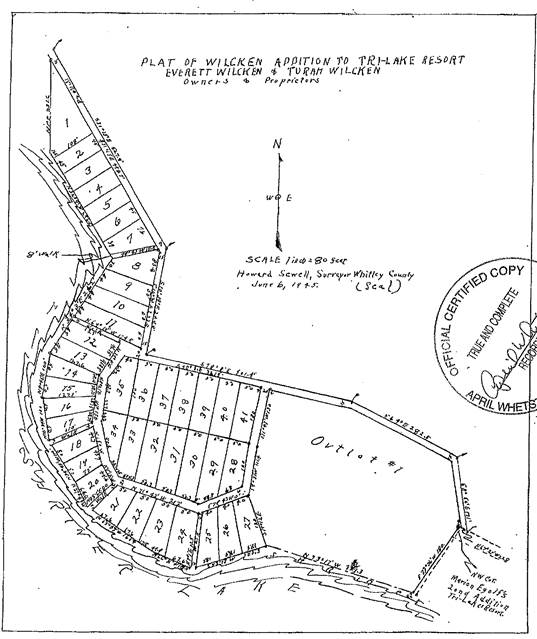
26. The Plat of Wilcken’s Addition to Tri-Lake Resort (“Wilcken’s Addition) is for a site that is adjacent to Shriner Lake in Whitley County. Wilcken’s Addition was recorded on June 6, 1945 at 3:00 p.m. in Plat Book B-15 with the Recorder of Whitley County, Indiana as follows:
Bulls’ “Designation of Evidence”, Item 1. Also, the Represented Respondents’ Exhibit A attached to “Affidavit of Dane D. Wilcken”.
27. The Plat of the “Wilcken’s Addition” included a legal description by the Whitley County Surveyor, as well as a sworn statement before a Notary Public dated June 6, 1945 as follows:
Comes now, Everett E. Wilcken and Turah Wilcken, the owners and proprietors of the above described land who hereby acknowledged the above plat of 41 lots and 1 outlot with drives, walks, and grounds adjacent to the lake, to be of the dimensions, shapes, location and numbers as are shown in said plat, to be their voluntary act and deed. Said proprietors now dedicate the streets, walks and grounds adjacent to the waters of the Lake to the uses of the public and dedicate said Plat to be known and designated as Wilcken’s Addition to Tri-Lake Resort.
Bulls’ “Designation of Evidence”, Item 1. Also, the Represented Respondents’ Exhibit A attached to “Affidavit of Dane D. Wilcken”.
[VOLUME 14, PAGE 12]
28. By warranty deed dated January 29, 1999, Clinton Doctor and Helen M. Doctor conveyed to the Bulls Lot 24 of Wilcken’s Addition. Bulls’ “Designation of Evidence”, Item 5. The Bulls are the owners of Lot 24. “Affidavit of Larry R. Bull”.
29. In 1995, David G. Trimmer and Lanna J. Trimmer purchased Lot 23 of Wilcken’s Addition. Lot 23 is adjacent to Lot 24 that is owned by the Bulls. Lot 23 and Lot 24 are separated by a ten-foot wide “Walk” as described on the plat. David G. Trimmer and Lanna J. Trimmer purchased Lot 29 and Lot 30 of Wilcken’s Addition in 2001. They subsequently purchased Lot 39, Lot 40, and Lot 41 Wilcken’s Addition. David G. Trimmer and Lanna J. Trimmer continue to own Lot 23, Lot 29, Lot 30, Lot 39, Lot 40, and Lot 41. “Affidavit of David G. Trimmer”.
30. The ten-foot wide “Walk” runs generally south-southwesterly from a 20-foot wide drive on the north side of Lot 23 and Lot 24 toward Shriner Lake. “Affidavit of Larry R. Bull” Plat in Finding 26. The 20-foot drive corresponds generally to East Fox Drive, Columbia City. Bulls’ “Designation of Evidence”, Item 2. “Grounds adjacent to waters of the Lake” of varying widths show on the Plat south of Lot 23 and Lot 24 and between them and the edge of Shriner Lake.
31. Shaffer acquired Lot 28 of Wilcken’s Addition on May 30, 2003. He is the owner of Lot 28. “Affidavit of Daren L. Shaffer”, including Exhibit B.
32. Matthew W. Field and Kim Cearbaugh own jointly Lot 31, Lot 32, Lot 37 and Lot 38 of Wilcken’s Addition. “Affidavit of Matthew W. Field”, including Exhibit A.
9. It was observed by Administrative Law Judge Jensen during the administrative hearing that an error may exist within Finding 29 of the Interlocutory Order. The parties were directed to the stated conclusion that “Lot 23 and Lot 24 are separated by a ten-foot wide “Walk”…” and to the Plat, which reflects the Walk is located on the east side of Lot 24 and between Lot 24 and Lot 25 of Wilcken’s Addition. The parties agreed. The parties also suggested that the reference to Lot 23 in the first sentence of Finding 30 should also be amended to refer to Lot 25.
10. Findings 29 and 30 of the Interlocutory are so corrected here.
Issues upon Which There Remains a Genuine Issue of Material Fact:
11. Through the Interlocutory Order it was determined that genuine issues of material fact remain as follows:
33. The DNR is charged “generally with enforcing the ‘laws for the conservation and development of the natural resources of Indiana.’” IC § 14-11-1-6. The DNR and the Commission implement the statutory process of issuing licenses for piers on public freshwater lakes. In adopting rules and issuing licenses, “the DNR is charged with considering a variety of factors, including the public rights listed in [IC § 14-26-2-5] and the interests of landowners who own property abutting the lake.” IC § 14-26-2-23(c) and IC § 14-26-2-23(e)(2). Kranz v. Meyers Subdivision Property Owners, 969 N.E.2d 1068, 1078 (Ind. App. 2012).
34. The Commission adopted rules at 312 IAC § 11 to authorize a general license for a qualified pier and to require an individual licenses for a pier that does not qualify for a general license. A pier placed before the effective date of a rule may be maintained as a lawful nonconforming use. Unless qualified as a lawful nonconforming use, a pier must conform to rules applicable to a general license or those applicable to an individual license. Mueller-Brown v. Caracci, 13 Caddnar 156 (2013).
35. The Claimants and the Respondents may litigate their respective proprietary interests landward of the shoreline of Shriner Lake through a civil action, and the Commission would implement a disposition of terrestrial ownership as it bears upon the exercise of riparian rights. The Commission generally lacks jurisdiction under the Lakes Preservation Act to determine disputes for land usage outside the shoreline of a public freshwater lake. McCulloch v. Day & Schramm, 12 Caddnar 40, 46 (2009). Although non-exclusive, the Commission “has jurisdiction to determine the scope of a lake access easement or riparian rights to the extent necessary to carry out the process of issuing permits for the placement of piers on public freshwater lakes.” Kranz v. Meyers Subdivision.
36. Generally, the owner of property adjacent to a river or lake has riparian rights associated with the ownership. Riparian rights may include access, swimming, fishing, bathing, and installing a pier. Daisy Farm Ltd. v. Morrolf, 886 N.E.2d 604, 607 (Ind. App. 2008), trans. denied. A person with a lake access easement does not acquire riparian rights but may acquire the right to “use the riparian rights of the servient tenant.” Klotz v. Horn, 558 Ind. 1096, 1097 (Ind. 1990). Emphasis provided by the court. Indiana courts distinguish between access obtained through a private easement and access obtained through a public highway.
37. The intentions of a riparian owner that grants an easement are implemented in construing an easement. In a plat or other recorded conveyance, clear language controls. “Dominant owners of lakeside easements may gain the rights to erect and maintain piers, moor boats and the like by the express language of the creating instrument.” Klotz at 1097 and 1098. The Commission determined a right-of-way for lake ingress and egress and “for the maintenance of a boat and swimming pier” expressed a clear intent and established the right to place a pier, even though the right-of-way was only three feet wide. Havel & Stickelmeyer v. Fisher, et al. at 11 Caddnar 110, 117 (2007). An easement six feet wide for a “boat landing” was found unambiguous and to provide a right to place a pier in Spaw v. Ashley, 12 Caddnar 233 (2010), affirmed on judicial review in Ashley v. Spaw, Allen Circuit Court, Cause No. 02CO1-1008-MI-1178 (2011).
38. The status of the law regarding private easements was summarized in Parkison v. McCue, 831 N.E.2d 118, 128 (Ind. Ct. App. 2005):
Easements burdening land with riparian rights attached do not necessarily provide the easement holder use of these riparian rights. Brown v. Heidersbach, 172 Ind. App. 434, 441, 360 N.E.2d 614, 619-20 (1977). Instead, we first look to the express language of the easement. Klotz v. Horn, 558 N.E.2d 1096, 1097-98 (Ind. 1990). “An instrument creating an easement must be construed according to the intention of the parties, as ascertained from all facts and circumstances, and from an examination of all its material parts.” Brown, 172 Ind.App. at 441, 360 N.E.2d at 620. Courts may resort to extrinsic evidence to ascertain the intent of the grantors creating the easement only where the language establishing the easement is ambiguous. Gunderson v. Rondenelli, 677 N.E.2d 601, 603 (Ind.Ct.App. 1997) (citing Klotz, 558 N.E.2d at 1098). A deed is ambiguous if it is susceptible to more than one interpretation and reasonably intelligent persons would honestly differ as to its meaning. See Abbey Villas Dev. Corp. v. Site Contractors, Inc., 716 N.E.2d 91, 100 (Ind. Ct.App. 1999), trans. denied.
39. “[G]enerally, access to a body of water is sought for particular purposes beyond merely reaching the water, and where such purposes are not plainly indicated, a court may resort to extrinsic evidence to assist the court in ascertaining what they may have been.” Klotz v. Horn at 1098 citing Badger v. Hill, 404 A.2d 222, 226 (Me. 1979). If the Commission determines the intent of an access from back lot owners to the shoreline of a public freshwater lake is ambiguous, the Commission may apply extrinsic evidence to determine the intent. Adochio, et al. v. Kranz, et al., 11 Caddnar 400 (2008) considered favorably in Kranz v. Meyers Subdivision Property Owners cited previously.
[VOLUME 14, PAGE 13]
40. A developer may intend to establish a road within a plat either for the private use of the residents of the addition or for general public use. A dedication for public use of a road adjacent to a public freshwater lake can be accomplished by common law or by statute. Altevogt v. Brand, 963 N.E.2d 1146, 1150 (Ind. App. 2012).
41. If access to a public freshwater lake is through a platted public road, an off-lake lot owner has no greater right to use the public road than any member of the general public. The easement is public and not private. Use of a public road to access the lake is a permitted use under the public easement and a non-exclusive right shared with the public. An off-lake landowner does not typically acquire the rights, even following continuous usage in excess of 20 years, to place a pier at the terminus of a public road on the shoreline of a public freshwater lake. A prescriptive easement is not established because the use is not exclusive. A person’s exercise of access rights “under a public easement is not exclusive precisely because that right is shared with others.” Bass v. Salyer, 923 N.E.2d 961, 969 (Ind. App. 2010). The Commission cited Bass as controlling in Plymate v. Paton and DNR, 13 Caddnar 28, 33 (2012) and Tersigni v. Osbon & Wright, 13 Caddnar 60, 63 (2012).
42. Abbs v. Town of Syracuse, 655 N.E.2d 114 (Ind. App. 1995) considered the intent of a public roadway and whether the local governmental unit may exercise riparian rights where a street or alley terminates on the shoreline of a public freshwater lake. The court concluded a factual basis could be established for the public dedication of a road that included a right in the governmental unit to determine the placement of piers. The Court of Appeals ruled an adequate basis was not made on summary judgment to support such a finding in favor of the town and remanded the action to the trial court for an evidentiary hearing.
43. A threshold question is whether the Walk referenced in Finding 30 has the characteristics of a public road or those of a private easement within the Wilcken’s Addition. In Bass v. Salyer, the determination that a drive was a public road was made after a hearing of the facts showing the county board of commissioners approved a subdivision plat before recordation, and the board subsequently vacated portions of the drive. In Plymate v. Paton, the determination was made after a hearing of the facts that demonstrated “Park Avenue” was used for years by boaters to exit the lake and access a nearby restaurant counter and grocery, and the board vacated a portion of the drive. In Tesigni v. Osbon & Wright, the parties did not contest on summary judgment that the drive was a “platted public road” for which the board of commissioners had declined a vacation petition.
44. The record on summary judgment is devoid of the perspectives of the Board of Commissioners of Whitley County towards the Walk. The Parties might determine the board’s perspectives are unnecessary to a disposition, but if that is so, the record of the proceeding should be developed to state clearly the determination. In any event, there is a genuine issue of material fact as to whether the Walk is a public road or merely an easement for the private use of lot owners in the Wilcken’s Addition.
45. The reported decisions cited by the Bulls and analyzed by the Represented Respondents generally support the proposition there is an inference an adjoining lot owner has title to the center of a right-of-way created by a highway. If there is such an inference, the Represented Respondents have presented enough to require its factual disposition. The factual basis for the inference is in genuine dispute.
46. The Walk might be analogized to a public highway but might be better considered a footpath or trail. Whether the analogy is persuasive may be a question of law or may be a mixed question of law and fact. Also, at least a casual observation of the Plat may suggest the Walk terminates not at the edge of Shriner Lake but instead at the grounds adjacent to the lake. Caution must be exercised to ensure the Parties rights to a fair determination of genuine issues.
47. The grounds adjacent to the waters of the Lake south of Lot 23 and Lot 24 are more poorly defined than the Walk. Even if Everett E. Wilcken and Turah Wilcken intended to dedicate streets and walks as public highways, and their intention was effective, a different intent was expressed with respect to the grounds adjacent to the waters of the Lake. If the intent was to transfer ownership of these grounds to adjoining landowners, the intent was ambiguous as best. A basis is not established for summary judgment and instead requires a factual determination.
12. The previous determination by ALJ Lucas in the Interlocutory Order accurately summarizes the heart of the issues remaining for resolution as “a genuine issue of material fact as to whether the Walk is a public road or merely an easement for the private use of lot owners in the Wilcken’s Addition.”
Findings of Fact with Respect Issues upon Which There Remains a Genuine Issue of Material Fact:
13. The factual evidence is generally not in dispute.
14. As evidence that the Walk is a “public way”, the Bulls offered minutes of the October 2, 2006 meeting of the Board of Commissioners of Whitley County (“Board”) at which a petition to vacate the Walk was considered. From the evidence it is clear that the Board did consider and reject the petition to vacate the Walk. Remaining unclear is the Board’s basis for rejecting the petition. The minutes of the Board’s meeting reflect the presentment of multiple bases for remonstrance, including that “the vacating of land cannot cause an inconvenience for property owners and cannot be used as a remedy to encroachments” as well as other unspecified statements in opposition. The minutes also reflect the statement of Dane Wilcken (“Wilcken”), the grandson of Everett E. Wilcken and Turah Wilcken, who said “the intent of his grandparents was for all property owners to have access to the lake by using the easements.” The minutes memorialize that the Board engaged in “further discussion” and denied the petition but does not record the reason(s) for the Board’s decision. Testimony of Bull, Claimants’ Exhibit Tab 5, (emphasis added). No one present during the Board’s consideration of the petition testified in further clarification. Testimony of Bull.
15. The legal description specifies that the identified Lots as well as “drives, walks and grounds adjacent to lake” will be determined as to “dimension, shape, location, and number” by that attached Plat.
16. The Plat of the Wilcken Addition sets out Lots 1 through 27 at locations consistent with the meanderings of the shoreline of Shriner Lake and Lots 28 through 41 are at locations not directly related to the shoreline of Shriner Lake. (Hereinafter Lots 1 through 27 will be referred to collectively as “the Lake Facing Lots” and Lots 28 through 41 will be referred to collectively as “the Back Lots”.) Testimony of Bull, Claimants’ Exhibit Tab 3.
17. In addition to the Lots, the Plat identifies five walks located between Lot 7 and Lot 8, between Lot 11 and Lot 12, between Lot 17 and Lot 18, between Lot 20 and Lot 21 and between Lot 24 and Lot 25, as well as a drive, which is located on the Plat consistent with the present location of East Fox Drive. As is noted in Finding 30 of the Interlocutory Order, the plat also reflects an area of land located between the Lake Facing Lots and the shoreline of Shriner Lake. Id.
18. Particularly relevant to this proceeding is the conclusion stated in Finding 30 of the Interlocutory Order, which is supported by independent evidence from the administrative hearing, that ground “of varying widths show on the Plat south of Lot 23 and Lot 24 and between them and the edge of Shriner Lake.”
19. To develop an accurate historical perspective, the discussion herein will necessarily consider and discuss the entirety of the Wilcken Addition, however, the issues to be determined herein pertain to the use of the one walk located between Lot 24 and Lot 25 (For consistency with references contained within the Interlocutory Order, the walk located between Lot 24 and Lot 25 will hereinafter be referred to as “the Walk”) by the Represented Respondents, Schaeffer and the Trimmers, all of whom own Back Lots within the Wilcken Addition.
20. The Plat specifies the intent of Everett E. Wilcken and Turah Wilcken to “dedicate the streets, walks and grounds adjacent to the waters of the lake to the use of the public.” [1]
[VOLUME 14, PAGE 14]
21. The Plat offers no differentiation in the dedication with respect to the streets, walks and the land area adjacent to Shriner Lake.
22. Kevin Michel (“Michel”) is a part owner of Walker and Associates who is a licensed professional engineer and has been engaged in land surveying for approximately 40 years. Of the 41 Lots within the Wilcken Addition, Walker and Associates has surveyed all except four or five. Testimony of Michel.
23. Through Walker and Associates’ extensive surveying, Michel was able to confirm that the boundary lines associated with Lots 16 through 27 do not reach the shoreline of Shriner Lake.[2] Testimony of Michel, Claimants’ Exhibit Tab 4 and Exhibit C.
24. Although not at the request of the Bulls, Walker and Associates did survey Lot 24 in 1998. Id. Through the 1998 survey, Michel was able to confirm specifically that Lot 24, now owned by the Bulls, does not abut the shoreline of Shriner Lake. Id.
25. Through the 1998 survey, Michel also confirmed that a strip of land lies between the end of the Walk and the shoreline of Shriner Lake. Id.
26. No evidence was offered to contradict the accuracy of the 1998 survey prepared by Walker and Associates. Specifically, Bull, who confirmed that he has not commissioned a survey of Lot 24, offered no evidence contrary to Michel’s conclusion that a strip of land exists between the shoreline of Shriner Lake and Lot 24 and the Walk.
27. Michel testified that the existence of a strip of land of varying widths lying between the Lake Facing Lots and the shoreline of Shriner Lake is consistent with the legal description contained within the Plat of the Wilcken Addition.
28. It is not disputed that the owners of the Lake Facing Lots have historically placed piers lakeward of the shoreline of Shriner Lake in front of the individual lots owned despite the fact that the land “adjacent to the waters of the lake” was dedicated to the “use of the public” and is not owned by the individual owners of the Lake Facing Lots.
29. The Bulls, similar to other Lake Facing Lot owners, maintain a personal pier in front of Lot 24. Testimony of Bull, Claimants’ Exhibit Tabs1, 7-9.
30. On cross examination Bull acquiesced to the possibility that if all the land adjacent to Shriner Lake is dedicated to the public the pier extending from the Walk is no more unlawful that the pier the Bulls maintain in front of Lot 24, or for that matter any pier maintained by any Lot owner within the Wilcken Addition. However, Bull expressed the belief that “each Lot owner has permission for a temporary pier by the DNR requirement.”
31. Brandon Forester (“Forester”) has served as the Whitley County Engineer from 2001 through 2007 and from 2009 to the present. In this capacity he serves as the technical advisor for the drainage board and the Whitley County Commissioners and as member of the plan commission as well as fulfilling other responsibilities. Forester has completed 30 credit hours of surveying courses, including courses specific to legal descriptions, surveying law and systems and is frequently called upon as the Whitley County Engineer to interpret legal descriptions. Testimony of Forester.
32. Forester offered uncontroverted evidence that the Whitley County tax records do not reflect a fee simple title holder for the Walk. The land area associated with the Walk is reflected as having no ownership for taxation or any other purpose.
33. Forester offered the opinion that a distinction between a dedication “to the use of the public” as compared to a dedication “to the public” “comes down to the intent of the developer.”
34. Whitley County does not maintain and has no obligation to maintain the Walk, which is an unimproved strip of land; not a street, not a road and not a highway. Testimony of Forester, Respondent’s Exhibit B.
35. From a review of Whitley County records encompassing June 7, 1943 through June 7, 1948 it was determined that Whitley County has not accepted the dedication of the Wilcken Addition made on June 6, 1945. Despite finding no acceptance of the Wilcken Addition at issue here, Whitley County did accept the Wilcken Second Addition in 1947. Testimony of Forester.
36. Various witnesses offered testimony regarding the use of the Walk for the placement of a pier and mooring of boats between the mid-1990s to the present. Only one witness, Wilcken, who is the 53 year old grandson of Everett E. Wilcken and Turah M. Wilcken, offered testimony regarding the use of the shoreline of Shriner Lake within Wilcken Addition, including the Walk, prior to the late 1990’s or early 2000’s.
37. Wilcken for the past 13 years has owned a Back Lot within the Wilcken Addition and has lived in the Wilcken Addition all of his life except for a span of time between 1979 to 1987 when he served in the military.[3] Testimony of Wilcken.
38. Wilcken testified from personal knowledge that a pier extended from the Walk in the 1960’s when he was 10 or 11 years of age. Wilcken explained that George and Edna Snyder used to live on Fox Drive in the home located on a Back Lot behind Lot 25, now owned by Schrimper, adding that George had “a little one…one and a half section pier out there for a little rowboat; I used to go fishing with him out on the sandbar in front of Jim’s house.” Wilcken confirmed that the rowboat remained moored at the pier.
39. Wilcken recalled another pier extending from the Walk in approximately 1987 after he returned from the Marine Corps although he was unable to state how long the pier was in place or identify the person(s) who constructed the pier or used it. The only boats observed being moored to the pier were rowboats. Id.
40. From his own personal observation Wilcken testified that members of the general public have never been known to utilize the walks or the shoreline of Shriner Lake. He noted that there have never been signs posted to identify the walks and no one except Lot owners would likely be aware of their existence.
41. Wilcken understood from his grandfather and father that the walks and shoreline areas were established to allow “people that bought property from him in the addition to be able to have access to put a boat in, go fishing, go swimming; those type of things.”
42. Wilcken acknowledged having no specific conversations with his grandfather about the placement of piers but noted conversations he had with his father about piers and his general understanding that all the Lot owners within the Wilcken Addition were to be allowed to place piers.
43. Bob Thompson, a Back Lot Owner, presently maintains a pier extending from the walk between Lot 7 and Lot 8 within the Wilcken Addition. Testimony of Wilcken.
44. In the 1970’s, the owner of Lake Facing Lot 8 contested the use of the walk situated between Lot 7 and Lot 8 for any purpose by the predecessor in title to Bob Thompson’s Back Lot property. Wilcken explained that he was a teenager and not involved but observed his father having to intervene in the dispute. Wilcken also expressed from personal observation that the Back Lot owner was ultimately able to utilize the walk and extend a pier from that walk. Wilcken had no knowledge of the means by which the dispute was ultimately resolved.
[VOLUME 14, PAGE 15]
45. Any pier placed into Shriner Lake by an owner of a Back Lot has been at the terminus of one of the walks but the evidence indicates that piers have been extended from three of the walks within Wilcken Addition including the walk between Lot 7 and Lot 8 and the Walk at issue here. Testimony of Wilcken. The third walk from which a pier has been extended was not identified although Field testified that at the time of his purchase of Lots within the Wilcken Addition in 2006 he, along with his real estate agent, walked the area and he observed piers extending from three of the walks. Testimony of Field.
46. There exists some disagreement with respect to the periods of time in which a pier has extended from the Walk. Bull testified that no pier extended from the Walk in January 1999 when the Bulls purchased Lot 24 and provided an aerial photograph purporting to have been taken on April 19, 1998 in support of his testimony. Claimants’ Exhibit Tab 6. Bull added that Clinton Doctor (“Doctor”) from whom the Bulls purchased Lot 24 attempted to sell his pontoon boat in 1999 and only after it did not sell did Doctor, in 2000, construct the pier in order to moor the pontoon boat. However, David Trimmer (D. Trimmer) whose family purchased Lot 23 in 1995, offered testimony that his son assisted Doctor, who in addition to owning Lake Facing Lot 24 also owned Back Lots 29 and 30, in the placement of the pier extended from the Walk in May 1998[4]. A portion of Field’s and Cearbaugh’s designated evidence in support of their cross motion for summary judgment included an affidavit provided by Doctor, who concurred with the testimony of D. Trimmer. In Doctor’s affidavit he explained that only months after placing the pier extending from the Walk he and his wife marketed Lot 24 for sale. The sale of Lot 24 would have left Doctor in possession of only Back Lots 29 and 30 thereby making it necessary for Doctor to identify a different location to moor his pontoon boat.
47. It seems reasonable to accept that there is a mistake with respect to either Bull’s or D. Trimmer’s and Doctor’s recollection of date the current pier was extended from the Walk but the exact date is not critical to this determination.
48. The evidence is consistent that from the time of the pier’s most recent placement at the terminus of the Walk between May 1998 and 2000 there has been consistent, although not continuous, use of the pier extending from the Walk for the mooring of boats by Lot owners within the Wilcken Addition. Lot owners known to have used the pier include Fields, Cearbaugh, Shaffer, the Trimmers and the Bulls. Testimony of Bull, Testimony of Trimmer, Testimony of Field.
49. The pier placed at the Walk (This pier will hereinafter be referred to as “the Walk Pier”) , whether in place when the Bulls purchased Lot 24 or installed later, originally and at least until 2005 extended straight out into Shriner Lake. Claimants’ Exhibit Tabs 8, Testimony of Bull. Later in time an “L” shaped patio section was added to the terminal end of the pier extending toward the east, or in the direction of Lot 25 owned by Schrimper. Testimony of Bull, Testimony of Fields, Claimants’ Exhibit Tabs 9 – 11. The patio section “floated away” in 2012 and has not been replaced. Testimony of Field.
50. The straight portion of the Walk Pier, consisting of three or four 8-foot sections making it approximately 20 to 24 feet in length. It has not been removed from the water since 2006 and its location has not been adjusted during that time. Id.
51. Bull, using the southwest survey pin for the Schrimper property attempted to identify the east boundary line of his property, Lot 24, which is shared with the western boundary line of the Walk. Through this method, Bull offered that the Walk Pier angles into the riparian zone associated with Lot 24. Testimony of Bull, Claimants’ Exhibit Tabs13-16, 20. Michel confirmed that Bull’s methodology for locating the property line is sound; however, expressed concern with the accuracy of the result. Michel explained that stretching of the string or other factors would render the outcome unreliable. Testimony of Michel.
52. The Walk Pier has predominantly been used by the Represented Respondents and Shaffer[5], prior to his sale of Lot 28. However, the Trimmers and the Bulls, along with possibly four or five other neighbors have, on occasion, moored boats to the Walk Pier for a few hours while conducted repair or maintenance work on their personal piers or for other similar reasons. Testimony of Bull, Testimony of D. Trimmer.
53. From approximately 2005 or 2007 when Shaffer purchased Lot 28 a fishing boat has been moored on the east side of the Walk Pier all summer every summer until Shaffer’s recent sale of Lot 28. The mooring of the fishing boat prevented other boats from utilizing the east side of the Walk Pier and consequently the Represented Respondents utilized the west side of the Walk Pier to moor their pontoon boat on occasion. Testimony of Bull.
54. The Represented Respondents have occasionally moored jet skis to the Walk Pier and in 2008 – 2009 they also on occasion moored a Pontoon boat and from 2009 - 2011 an 18 foot Bayliner. Testimony of Field.
55. Except in 2008 and possibly 2009 when the Represented Respondents’ moored watercraft to the Walk Pier throughout the summer, the watercraft has only been moored at the Walk Pier for a weekend or periods throughout a day when in use. The Represented Respondents have not moored more than one watercraft to the Walk Pier at the same time. Testimony of Field.
56. Bull concurred that the Represented Respondents only moored the pontoon boat to the Walk Pier “maybe two or three times during a summer” but that visitors of Shaffer would also, on occasion, moor boats to the Walk Pier in addition to the fishing boat. Bull acknowledged that the Represented Respondents have generally been courteous with respect to their use of the Walk Pier.
57. The Bulls’ pier extends from the shoreline for an unknown distance with an “L” section at the lakeward end extending eastward toward the Walk Pier. Bull expressed that the Walk Pier interferes with the use of the Bulls’ pier and riparian area, specifically noting that the eastern-most portion of the Bulls’ pier, which is the “L” portion, has been hit by boats on two occasions while attempting to exit the west side of the Walk Pier. Bull stated that he moors boats on the west side of his pier and the east side of the pier, protected by the “L” shape, is predominantly used as a swim area, although in the past his son, who does not live with the Bulls, has moored a jet ski on the east side of the pier. Bull observed that navigating boats onto the west side of the Walk Pier potentially exposed swimmers to a hazard.
58. Field expressed that he has never had difficulty navigating into or away from the west side of the Walk Pier.
Conclusions of Law:
59. The parties reasonable albeit contradictory interpretations of the dedication along with ALJ Lucas’ conclusion that “the Walk might be analogized to a public highway but might be better considered a footpath or trail” demonstrates that the language of dedication “to the use of the public” is “susceptible to more than one interpretation and reasonably intelligent persons would honestly differ as to its meaning”. Resolution of the ambiguity obligates the consideration of extrinsic evidence to ascertain the true intent of the grantor. Klotz v. Horn, supra.
60. Resolving the remaining issue requires defining Everett E. Wilcken’s and Turah Wilcken’s reference to “the public” in their dedication of the streets, walks and ground adjacent to Shriner Lake.
[VOLUME 14, PAGE 16]
61. The Bulls maintain that the Board possesses only the jurisdiction granted by I.C. § 36-7-3-12 and may only consider, as relevant here, the vacation of a “public way”, which is defined at I.C. § 36-7-1-17 as “highway, street, avenue, boulevard, road, lane, or alley”. The Bulls maintain that the act of the Board to accept jurisdiction of the petition to vacate the Walk provides conclusive evidence that the Walk is a public way dedicated to the general public as a highway.
62. Conversely, the Board’s denial of the petition without an express basis being identified within the minutes affords equal validity to a conclusion that it determined the Walk to be an easement for the benefit of other property owners over which it could not exercise jurisdiction. The record of action of the Board does not provide a reasonable basis for concluding that the Walk is either a “public way”, as the Bulls contend, or is an easement, as the Respondents maintain.
63. On the premise that the Walk is a public highway, the Bulls further assert that as the owner of the land abutting the Walk on the west they are the owners of the land associated with the western one-half of the Walk. The Bulls acknowledge that Schrimper, the owners of Lot 25, would be the owner of the eastern one-half of the land associated with the Walk. The Bulls proceed by correctly citing Bass v. Salyer for the proposition that “riparian rights arise from ownership of the land appurtenant to the water,” 923 N.E.2d 961 (Ind. App. 2010), in claiming that as the owners of the land associated with the Walk, “no persons, other than the owners of Lots 24 and 25, have any riparian rights at the lakeshore boundary of the walk.” Claimants’ Post-Trial Brief, pgs.3-4.
64. The Bulls’ assertion is flawed in two ways.
65. First, to obtain riparian rights associated with the land attributable to the Walk, that land must be appurtenant to the shoreline of Shriner Lake. It is not. The uncontested evidence adduced at the administrative hearing establishes that the Walk ends approximately five feet landward of the shoreline of Shriner Lake. Testimony of Michel, Represented Respondents’ Exhibit C. Because the Walk is comprised of land that is not located adjacent to Shriner Lake there can exist no riparian rights by virtue of the ownership of the land. Thus, neither the Bulls, nor the owners of Lot 25, nor any other person may obtain riparian rights through the ownership of the Walk. Bass, supra.
66. Second, consideration of all the facts and circumstances associated with the dedication of the streets, walks and grounds adjacent to Shriner Lake support the conclusion that the areas are easements for use by the Lot Owners of the Wilcken Addition and are not public ways.
67. Because the language of the Plat is ambiguous, the intent of the dedication is appropriately ascertained from extrinsic evidence. Abbs v. Town of Syracuse, 686 NE 2d 928, (Ind. App. 1997) citing Klotz v. Horn, 558 N.E.2d 1096, 1098 (Ind.1990); Metcalf v. Houk, 644 N.E.2d 597, 600 (Ind.Ct.App.1994); Brown v. Heidersbach, 172 Ind.App. 434, 441, 360 N.E.2d 614, 621 (1977); Kranz v. Meyers Subdivision Property Owners, 969 N.E.2d 1068, 1078 (Ind. App. 2012).
68. Wilcken’s testimony was the subject of a proper hearsay objection by the Bulls. In accordance with I.C. § 4-21.5-3-26(a), any testimony of Wilcken determined to be hearsay that “does not fall within a recognized exception to the hearsay rule” has not been utilized as the sole support for a resulting order.
69. Because the Plat makes no distinction with respect to the dedication of the walks, streets/drives and the land adjacent to the shoreline of Shriner Lake, a determination, consistent with the Bulls’ contention, that the Walk is a public highway would necessitate the conclusion that the streets as well as the land adjacent to Shriner Lake are also public highways.
70. A conclusion that the land adjacent to the shoreline of Shriner Lake is a public way would require a significant alteration of the use historically made of the shoreline, particularly but not exclusively, by the owners of the Lake Facing Lots.
71. In this regard, Finding 41 of ALJ Lucas’ Interlocutory Order bears repeating:
If access to a public freshwater lake is through a platted public road, an off-lake lot owner has no greater right to use the public road than any member of the general public. The easement is public and not private. Use of a public road to access the lake is a permitted use under the public easement and a non-exclusive right shared with the public. An off-lake landowner does not typically acquire the rights, even following continuous usage in excess of 20 years, to place a pier at the terminus of a public road on the shoreline of a public freshwater lake. A prescriptive easement is not established because the use is not exclusive. A person’s exercise of access rights “under a public easement is not exclusive precisely because that right is shared with others.” Bass v. Salyer, 923 N.E.2d 961, 969 (Ind. App. 2010). The Commission cited Bass as controlling in Plymate v. Paton and DNR, 13 Caddnar 28, 33 (2012) and Tersigni v. Osbon & Wright, 13 Caddnar 60, 63 (2012).
72. Under the guidance of Bass v. Salyer, if the strip of property located adjacent to Shriner Lake, which separates the Lake Facing Lots from the shoreline of Shriner Lake, is a public highway, as the Bulls maintain, the owners of the Lake Facing Lots as well as the owners of the Back Lots would be characterized as “off lake owners” who possess no right greater than the rights of the general public. Under this analysis it is likely that no Lot owner in Wilcken Addition, whether the owner of a Lake Facing Lot or the owner of a Back Lot, would possess the right to use the riparian rights associated with the land adjacent to Shriner Lake. This outcome is wholly inconsistent with the evidence.
73. The evidence is similarly certain that the walk situated between Lot 7 and Lot 8 has been used by Back Lot owners since as early as the 1970’s and the Walk has been used by Back Lot owners since as early as the 1960’s for the placement of piers and mooring of boats.
74. The past and current use of the shoreline of Shriner Lake within the Wilcken Addition supports the interpretation of the dedication of the “streets, walks and grounds adjacent to the waters of the lake” within the legal description of the Plat as creating an easement in favor of the Lot Owners within the Wilcken Addition. Adochio, et al. v. Kranz, et al., 11 Caddnar 400 (2008) Kranz v. Meyers Subdivision Property Owners, 969 N.E.2d 1068, 1078 (Ind. App. 2012).
75. As noted in Finding 35 of the Interlocutory Order, “the Commission ‘has jurisdiction to determine the scope of a lake access easement or riparian rights to the extent necessary to carry out the process of issuing permits for the placement of piers on public freshwater lakes.’ Kranz v. Meyers Subdivision.” A determination as to the dedication of the streets within the Wilcken Addition is not necessary with respect to the placement of piers on Shriner Lake and for that reason any issues surrounding the dedication of the streets should be characterized as an observation. Through the required consideration of the Plat, there exists only one street within the Wilcken Addition, which is presently known as East Fox Drive. Although there is no evidence indicating that this street is a private drive the use of which is restricted by signage or gates, it is likewise not a thoroughfare. The drive both begins and ends at what is now known as Wilcken Road making only a loop around the Wilcken Addition to provide access to the individual lots. The street, in similar fashion, to the walks and grounds adjacent to the lake, predominantly serve the residents of the Wilcken Addition. The conclusion that the walks and grounds adjacent to Shriner Lake are easements as opposed to a conclusion that they are public ways does not appear inconsistent with the intended use of the street.
76. Through the easements associated with the walks and the grounds adjacent to the shoreline of Shriner Lake the Lot Owners within the Wilcken Addition are granted the use of the servient estates riparian rights. Klotz v. Horn, 558 Ind. 1096, 1097 (Ind. 1990). In this instance that use includes the right to place piers and moor boats but the owners of Back Lots are limited to the use of the walks for purposes of exercising these riparian rights.
77. “Riparian Zones within Public Freshwater Lakes and Navigable Waters”, Information Bulletin #56 (Second Amendment), Indiana Register at 20100331-IR-312100175NRA (March 31, 2010) (“Information Bulletin 56”) is appropriately considered in determining the boundaries of individual riparian zones. Mueller-Brown v. Caracci, 13 CADDNAR 156 (2013). In this matter, Robert W. Wilkinson[6] (“Wilkinson”), the Head of Surveying and Mapping for the DNR Division of Water, prepared a report and map depicting the riparian zones “as they would be delineated using the Second Principle and the Third Principle” of Information Bulletin 56. (The report and map were admitted as Claimants Exhibit Tab 24 for demonstrative purposes only.)
[VOLUME 14, PAGE 17]
78. The report prepared by Wilkinson expressly identifies the “limited accuracy” of the data upon which it is based suggesting that the “services of a professional land surveyor should be obtained…” There is no agreement amongst the parties as to the appropriate principle by which the riparian zones should be identified.
79. From a review of Wilkinson’s map in combination with the review of the various aerial photographs placed in evidence, application of the Second Principle of Information Bulletin 56, which involves the extension of terrestrial property lines into the waters of a public freshwater lake, appears most consistent with the current use and existing structures extending into Shriner Lake from the shoreline areas correlating with Lot 24, Lot 25 and the Walk.
80. It is further noted that while the instant determination may appear to have broad-based consequences within the Wilcken Addition, this order is expressly limited in application to the parties and the issue of riparian rights associated with Lot 24, Lot 25 and the Walk.
81. The Department correctly observes the possibility that a pier located at the shoreline of Shriner Lake correlating to the location of the Walk within the Wilcken Addition may qualify as a “group pier”, which is defined as:
Sec. 11.5. "Group pier" means a pier that provides docking space for any of the following:
(1) At least five (5) separate property owners.
(2) At least five (5) rental units.
(3) An association.
(4) A condominium, cooperative, or other form of horizontal property.
(5) A subdivision or an addition.
(6) A conservancy district.
(7) A campground.
(8) A mobile home park.
(9) A club that has, as a purpose, the use of public waters for:
(A) boating;
(B) fishing;
(C) hunting;
(D) trapping; or
(E) similar activities.
82. Fourteen Back Lots exist within the Plat of the Wilcken Addition but at present only two residences have been constructed on the Back Lots. One of the residences is located on Lot 28 and is owned by Schaeffer while the second residence is owned by the Represented Respondents and is located on one or more of Back Lots 31, 32, 37 and 38. Claimants’’ Exhibit Tab 8. Back Lots 29, 30, 39 – 41, owned by the Trimmers were described as “extra parking” and “investment” but have not been developed with a residence. Testimony of D. Trimmer. The evidence supports the conclusion that Back Lots 33 – 36 have not been developed with a residence but the record is void of additional information about these Back Lots. As is the present situation for the Trimmers, other Back Lots are understood to be owned by individuals who also own Lake Facing Lots and maintain piers in front of their Lake Facing Lot. Testimony of Bull. However, the potential exists for one or more of Back Lots 29 & 30, 33 – 36 and 39 – 41 to be further sold and developed such that the number of Back Lot owners could rise to 11.[7]
83. While a pier for use by the Represented Respondents, the Trimmers and Schaeffer would not constitute a “group pier” the Department’s prospective interest in the subject is understandable.
84. A pier like the Walk Pier will frequently qualify for placement within a public freshwater lake by virtue of a general license established at 312 IAC 11-3-1(a). However, 312 IAC 11-3-1(b) specifies as follows:
(b) In order for a temporary structure to qualify, the structure must satisfy each of the following:
(1) Be easily removable.
(2) Not infringe on the access of an adjacent landowner to the public freshwater lake.
(3) Not unduly restrict navigation.
(4) Not be unusually wide or long relative to similar structures within the vicinity on the same public freshwater lake.
(5) Not extend more than one hundred fifty (150) feet from the shoreline or water line.
(6) If a pier, not extend over water that is continuously more than six (6) feet deep to a distance of one hundred fifty (150)
feet from the shoreline or water line.
(7) Not be a marina.
(8) Not be a group pier.
(9) Be placed by a riparian owner or with the written approval of a riparian owner.
85. A temporary structure that does not qualify for placement under 312 IAC 11-3-1, may only be constructed within a public freshwater lake under the authority of an individual license issued under 312 IAC 11-3-3:
Sec. 3. (a) Except as provided in section 1 of this rule and in subsection (c), a structure placed within the shoreline or water line of a public freshwater lake requires a written license issued by the department under IC 14-26-2 and this rule.
(b) Except as provided in 312 IAC 11-4-7, a structure that is located on a public freshwater lake:
(1) more than one hundred fifty (150) feet; and
(2) less than two hundred (200) feet;
from the shoreline or water line requires a written license under IC 14-26-2, this rule, IC 14-15-7-3, and 312 IAC 5-4. The department may provide that the multiple licensing requirements of this subsection be satisfied with a single written license.
(c) Except as provided in 312 IAC 11-4-7, a structure that is located:
(1) on a public freshwater lake; and
(2) not less than two hundred (200) feet from the shoreline or water line;
does not require a license under IC 14-26-2 and this rule, but the structure does require a license under IC 14-15-7-3 and 312 IAC 5-4. Only a navigation aid or water recreation structure can be licensed under 312 IAC 5-4.
(d) The director or a delegate shall not issue a license under this rule except upon a written determination that shows the following:
(1) The license, including conditions attached to the license, conforms to IC 14-26-2 and this rule. In making the determination, there shall be a determination that issuance of the permit would not result in significant environmental harm to the public freshwater lake.
(2) The applicant has demonstrated that an owner of each parcel of real estate, reasonably known to be adjacent to the real estate described in subsection (e)(2), has been notified under IC 14-11-4 and 312 IAC 2-3.
(e) An application for a license under this section must include a description of the following:
(1) The permanent structure, including plans and specifications of sufficient detail for the department to evaluate the project under IC 14-26-2 and this rule.
(2) The real estate:
(A) on which the structure would be located; or
(B) that the structure would benefit.
(f) Examples of a structure that requires a written license under this section include the following:
(1) A marina.
(2) A group pier.
(3) A new seawall or a seawall refacing.
(4) An underwater beach.
(5) A boat well excavation, construction, or fill.
(6) A fish attractor.
(7) A pier that is supported by a structure permanently mounted in, or affixed to, the bed of the lake.
(8) A boathouse that is totally or partially enclosed on the sides. This structure ordinarily should be:
(A) placed over a boat well constructed landward of the shoreline or water line; and
(B) constructed only after a permit is obtained to alter the shoreline or water line.
[VOLUME 14, PAGE 18]
86. It is determined that the Respondents are entitled to use the riparian rights of the servient estate associated with the grounds adjacent to Shriner lake within the lateral confines of the Walk’s boundaries, however, that use must comply with the DNR’s obligation to regulate and enforce rules directed towards the conservation and development of public freshwater lakes. See Finding 33 of the Interlocutory Order.
87. In light of the Walk’s modest width and the potential use that could be made of the Walk Pier, the Bulls’ concerns about navigation and safety are comprehensible.
[EDITOR’S NOTE: The original format of the Administrative Law Judge’s Findings of Fact, Conclusions of Law, and Final Order has been modified to correspond with CADDNAR format. The Final Order, Paragraphs 88 through 95, has been relocated to the “Final Order” section at the beginning of this document.]
[1] The Plat’s legal description also refers to “drives” in a manner synonymous with the reference to “streets” and references “grounds adjacent to the waters of the lake” in a manner synonymous with a reference to “grounds adjacent to the lake”. These references are treated in this order as interchangeable and without distinction.
[2] There was no direct evidence presented with respect to the land adjacent to the shoreline correlating to the location of Lots 1-15.
[3] On cross examination Wilcken was asked as a Back Lot Owner whether his lake access required the use of one of the walks. Wilcken confirmed that he has access through property now owned by his son and is not in need of access to Shriner Lake through the use of a walk.
[4] The aerial photograph offered by Bull, which was taken in April, 1998 is not inconsistent with D. Trimmer’s testimony or the affidavit of Doctor, who concur that the pier extending from the Walk was constructed in May 1998.
[5] The testimony indicates that Shaffer purchased and turned the home located on Lot 28 into a rental property in or near 2005. It is not particularly important to the outcome whether the use of the Walk Pier was by Shaffer personally or by the renters of the home on Lot 28 and for that reason all use made by the owner or renters of Lot 28 will be referred to as Shaffer’s use.
[6] Wilkinson died on May 19, 2013.
[7] While it might be reasonable to conclude that the Back Lot owners’ access to Shriner Lake would be divided between the five walks that is not an issue appropriate for decision here.