CADDNAR
[CITE: Meyers Subdivision POA v. DNR and Kranz, 12 CADDNAR 282 (2011)]
[VOLUME 12, PAGE 282]
Cause #: 10-093W
Caption: Meyers Subdivision POA v. DNR and Kranz
Administrative Law Judge: Lucas
Attorneys: Kocher (Meyers); Wyndham (DNR); Ochs (Kranz)
Date: January 14, 2011
FINAL ORDER
[NOTE: ON FEBRUARY 11, 2011, KRANZ FILED FOR JUDICIAL REVIEW
IN THE STARKE CIRCUIT COURT (75C01-1102-PL-002). ON NOVEMBER 30, 2011, STARKE
CIRCUIT COURT ENTERED ITS ORDER. ON
DECEMBER 27, 2011, KRANZ APPEALED (75A03-1112-PL-00577). ON JUNE 27, 2012 COURT
OF APPEALS ENTERED OPINION
AFFIRMING LOWER COURT AND ALJ. ON AUGUST 28, 3012, COURT OF APPEALS ENTERED OPINION
ON REHEARING “AFFIRMING ORIGINAL OPINION IN ALL RESPECTS”. ON SEPTEMBER 18,
2012, KRANZ SOUGHT PETITION TO TRANSFER.
ON DECEMBER 27, 2012, INDIANA SUPREME COURT DENIED TRANSFER.]
Paragraph (1) Straight-line extensions into Bass Lake of the common terrestrial property line of Bartoszek Lot 48 and Kranz Lot 49, as well as the boundaries of the 15-foot wide subject easement, provide appropriate delineations of the riparian zones of Bartoszek, the Kranzes, and the Easement Holders.
Paragraph (2) When Bass Lake is at 713.65 feet elevation, Sea Level Datum, the face of a glacial stone seawall along Bartoszek Lot 48 and Kranz Lot 49 forms its “shoreline or water line” under the Lakes Preservation Act.
Paragraph (3) A license to MSPOA is approved to place a group pier within but no nearer than two feet southwesterly from the northeastern boundary of the subject easement and no nearer than nine feet northeasterly from the common boundary of Bartoszek’s Lot 48 and Kranzes’ Lot 49. The group pier must not exceed 125 feet long, measured from the shoreline or water line, and boats must not be moored along the pier. Authorization is given for the three-step ladder but is denied for the two-foot wide sitting bench referenced in Finding 29.
Paragraph (4) The Kranzes’ pier must be relocated so that its southwestern boundary is no nearer than 14 feet from the northeastern boundary of the subject easement (stated in the alternative, no nearer than 29 feet from the common boundary of Bartoszek’s Lot 48 and Kranzes’ Lot 49).
Paragraph (5) The Bartoszek’s pier must be relocated so that its northeastern boundary is no nearer than seven feet from the common boundary of Bartoszek’s Lot 48 and Kranzes’ Lot 49.
Paragraph (6) This Final Order is intended to provide at least 16 feet of clearance between the Kranzes’ pier and the MSPOA’s pier and at least 16 feet of clearance between the Bartoszek’s pier and the MSPOA’s pier. No limitation is placed on the length of the Bartoszek’s pier or the Kranzes’ pier, other than that their lengths must not violate 312 IAC 5-6-3(a) or the reasonableness test. Boats must not be moored along the Kranzes’ pier or the Bartoszek’s pier that would reduce the 16 feet of clearance referenced in this Paragraph.
Paragraph (7) MSPOA, the Kranzes, and Bartoszek must not place or maintain an individual pier or a group pier in Bass Lake which is not in conformance with this Final Order.
Paragraph (8) This Final Order is effective February 1, 2011 and supersedes the “Order Regarding Temporary Pier” which the administrative law judge entered on June 1, 2010.
FINDINGS OF FACT AND CONCLUSIONS OF LAW
A. Statement of the Case and Jurisdiction
1. On May 12, 2010, Meyers Subdivision Property Owners Association, Inc. (“MSPOA”) filed a “Petition for Administrative Review” from the denial by the Department of Natural Resources (the “DNR”) of a license under Ind. Code § 14-26-2 (sometimes referred to as the “Lakes Preservation Act”), and rules adopted by the Natural Resources Commission (the “Commission”) at 312 Ind. Admin. Code § 11-1 through 312 Ind. Admin. Code § 11-5 to assist with implementation of the Lakes Preservation Act, to place a “group pier” at a site located within Bass Lake, Starke County, Indiana. The DNR designated the license application “PL-21411”.
2. Bass Lake is a “public freshwater lake” as defined under IC 14-26-2-3 and is subject to DNR regulation under the Lakes Preservation Act. Zapffe v. Srbeny 587 N.E.2d 177 (Ind. App. 1992).
3. MSPOA’s “Petition for Administrative Review” initiated a proceeding under Ind. Code § 4-21.5 (sometimes referred to as the “Administrative Orders and Procedures Act” or “AOPA”) and rules to assist with AOPA implementation that the Commission adopted at 312 Ind. Admin. Code § 3-1.
4. Under AOPA, the Commission is the “ultimate authority” for the DNR for a proceeding initiated to obtain administrative review of a licensure determination under the Lakes Preservation Act and 312 IAC 11-1 through 312 IAC 11-5. IC 14-10-2-3. Roebel, et al. v. Vorndran, et al., 11 Caddnar 250 (2008)[1]. The Commission appoints administrative law judges to conduct proceedings under AOPA. IC 14-10-2-2. Stephen Lucas was appointed the administrative law judge for this proceeding.
5. On May 17, the administrative law judge entered a “Notice of Initial Prehearing, Conference” with copies of the “Petition for Administrative Review” attached, and caused service upon MSPOA and the DNR. At the request of the administrative law judge, the DNR’s Division of Water provided a service list of persons who were notified of the license application for PL-21411. A “Notice to Potentially Interested Persons” was sent to these persons to advise them of the proceeding and of the scheduling of the initial prehearing conference.
[VOLUME 12, PAGE 283]
6. On May 20, Gunther Kranz and Carol Kranz (the “Kranzes”) filed their “Motion to Intervene”. On May 26, 2010, Christopher Bartoszek (“Bartoszek”) filed his “Motion to Intervene”.
7. The initial prehearing conference was conducted as scheduled on May 28. During the conference, MSPOA expressed opposition to both motions to intervene. The DNR stated it did not object to either motion to intervene. An “Objection to Motion to Intervene” filed by MSPOA in an antecedent proceeding was incorporated by reference. MSPOA, the DNR, the Kranzes, and Bartoszek were provided until June 4 to supplement the record with respect to the motions to intervene, but no pleadings or documents were filed subsequently.
8. In considering the motions to intervene, the administrative law judge observed MSPOA was seeking to exercise the enjoyment of the dominant estate in an easement (the “subject easement” as described later in these Findings) which crosses a portion of the lands and the riparian waters of the Kranzes. The Kranzes hold the servient estate. Bartoszek was a riparian owner whose real estate abuts the real estate of MSPOA and the Kranzes. The Kranzes and Bartoszek have substantial and direct proprietary interests, as referenced by IC 4-21.5-3-5(b)(5), in the outcome of the DNR’s licensure action. The administrative law judge properly granted the motions of both to intervene.
9. MSPOA, the DNR, the Kranzes, and Bartoszek are collectively the “parties”.
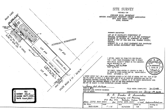
10. The term “riparian rights” indicates a bundle of rights that turn on the physical relationship of a body of water to the abutting land. Riparian rights are special rights pertaining to the use of a waterway adjoining the owner’s property. Persons who enjoy riparian rights may access the waterway to swim, fish, and boat. The installation of a pier may be a reasonable use. Daisy Farm Limited Partnership v. Morrolf, 886 N.E.2d 604, 607 (Ind. App. 2008).
11. In addition to possible unreasonable interference with public navigation, a person who places a pier must not interfere with the rights of other riparian owners. Conflicts with riparian uses other than piers are addressed in terms of whether the interference is unreasonable. In conflicts between the owners of competing piers, the problem will usually be resolved by drawing boundaries between the competing interests in the lake. These boundaries are drawn in such a way as to ensure, so far as possible, each person who is entitled to enjoy riparian rights will have a reasonable access to navigable waters. Robert E. Beck, Waters and Water Rights § 6.01(a)(2)(2007).
12. The Commission has jurisdiction to adjudicate MSPOA’s “Petition for Administrative Review” under IC 14-10-2-3 and under IC 14-26-2-23. The jurisdiction is based on review of the licensure determination and on IC 14-26-2-23(c)(5) pertaining to the “interests of a landowner having property rights abutting the public freshwater lake or rights to access the public freshwater lake”. See, also, IC 14-26-2-23(d) which governs dispute resolutions.
13. For consideration is the fate of MSPOA’s license application, as well as the direct or derivative riparian rights of the Kranzes, Bartoszek, and MSPOA. The rights of each are correlative to the rights of the others and to the public trust for which the DNR is the trustee.
14. The Commission has jurisdiction over the subject matter and over the persons of the parties.
B. Res Judicata Effect of Adochio, et al. v. Kranz, et al., 11 Caddnar 400 (2008)
15. The parties stipulated the Commission’s decision in Adochio, et al. v. Kranz, et al., 11 Caddnar 400 (2008) [Administrative Cause No. 07-204W] is entitled to res judicata application. This decision is sometimes referenced here as the “Adochio proceeding”. See F. Statement of Issues in “Report of Initial Prehearing Conference, Notice of Telephone Status Conference, and Notice of Hearing” (June 1, 2010).[2]
16. In the Adochio proceeding, the Commission construed a “Vacation and Relocation of Easement” in favor of the Meyers Subdivision over the lands and riparian waters of the Kranzes, particularly as the easement pertains to the property rights within Bass Lake of Nancy Adochio and others who are off-lake lot owners in the Meyers Subdivision (the “Easement Holders”), the Kranzes, Bartoszek, and the DNR.
17. The “Vacation and Relocation of Easement” (the “subject easement”) provides in substantive part as follows:
VACATION AND RELOCATION OF EASEMENT
In consideration of the easement hereinafter granted, the undersigned, constituting all of the owners of lots and lands in Joseph Meyers Subdivision to Bass Lake, in Starke County, Indiana, recorded in Plat Book No. 2 pages 141-142 in the office of the Recorder of Starke County, Indiana, or lots in First Addition to Joseph Meyers Subdivision to Bass Lake, recorded in Plat Book 2, pages 168 and 169 in the office of the Recorder of Starke County, Indiana; do
hereby vacate the lake easement of a foot path over the northeasterly 15 feet of Lot Number 48 in Scoville’s Subdivision of Original Lot 2 in the N.E. ¼ of Section 24, Township 32 North, Range 2 West of the 2nd P.m., as heretofore dedicated and granted as an appurtenance to the dwelling owners on said subdivisions described above or as appurtenant to any other lots in Scoville’s Subdivision of Original Lot 2 in Section 24, Township 32 North, Range 2 West of the 2nd P.M., as may have been granted by the said Joseph Meyers and Blanche Meyers, husband and wife. And the undersigned do hereby release all rights in and to said lake easement over the said northeasterly 15 feet in and to said lake easement over the said northeasterly 15 feet of Lot Number 48 in Scoville’s Subdivision of Original Lot 2 in the N.E. ¼ of Section 24, Township 32 North, Range 2 West of the 2nd P.M.
[VOLUME 12, PAGE 284]
In consideration of the premises and vacation of the easement above described, Joseph Meyers and Blanche Meyers, husband and wife, do hereby dedicate and grant, to owners of lots in, or within the boundary lines of Joseph Meyers Subdivision and Joseph Meyers First Addition to Bass Lake recorded in Plat Boot 2 pages 141-142 and 168-169, a foot path over the southwesterly 15 feet of Lot Number 49 in Scoville’s Subdivision of Original Lot 2 in the N.E. ¼ of Section 24, Township 32 North, Range 2 West of the 2nd P.M., extending 15 feet wide from Lakeside Avenue to the waters of Bass Lake; said foot path to be along and adjacent to the southwesterly line of said Lot Number 49.
All owners of lands joining herein do hereby accept the easement last above described and do relinquish and release all right or title to an easement over the northeasterly 15 feet of Lot Number 48 in Scoville’s Subdivision of Original Lot 2 in the N.E. ¼ of Section 24, Township 32 North, Range 2 West of the 2nd P.M., in Starke County, Indiana.
IN WITNESS WHEREOF, the undersigned have hereunto set their hands and seals as of this 14th day of April 1962.
Adochio proceeding at 11 Caddnar 401 and 402 [Finding 2][3].
18. The Kranzes are owners of Lot 49 of the Meyers Subdivision (sometimes referred to as “Kranz Lot 49”). Bartoszek is the owner of Lot 48 (sometimes referred to as “Bartoszek Lot 48”) which is immediately southwest of and adjacent to Kranz Lot 49 and the subject easement. Adochio proceeding at 11 Caddnar 403 [Finding 5].
19. On the subject easement, the Easement Holders enjoy the dominant estate for a 15-foot wide easement across the southwestern extremity of Kranz Lot 49. The Kranzes have the servient estate. Adochio proceeding at 11 Caddnar 410 [Finding 27].
20. The Kranzes and Bartoszek share a common property line and are riparian owners of Bass Lake. The subject easement borders and is immediately northeast of Bartoszek Lot 48 but does not encumber Bartoszek Lot 48. Adochio proceeding at 11 Caddnar 410 [Finding 28].
21. The Commission found that Easement Holders “are not riparian owners. Yet a determination that persons are not riparian owners ‘does not settle the question of whether they are entitled to install and use a dock in the property enjoyment of their easement for right-of-way purposes.’ Klotz v. Horn, 558 N.E.2d 1096, 1097 (Ind. 1990), citing Farnes v. Lane, 281 Minn. 222, 161 N.W.2d 297, 301 (Minn. 1968). ‘The issue is not whether the easement holder attains riparian ownership status, but rather, whether he is entitled to use the riparian rights of the servient tenant who has given him access to the body of water bordering the servient estate.’ Emphasis supplied by court in Klotz at 1097.” Adochio proceeding at 11 Caddnar 411 [Finding 29].
22. “The intentions of the riparian owner who granted an easement are to be implemented in construing the easement. In a plat or other recorded conveyance, clear language controls. ‘Dominant owners of lakeside easements may gain the rights to erect and maintain piers, moor boats and the like by the express language of the creating instrument.’ Klotz at 1097 and 1098.” Citation was also made to Havel & Stickelmeyer at 11 Caddnar 110, 117 where the Commission previously determined “a right-of-way for lake ingress and egress and ‘for the maintenance of a boat and swimming pier’ expressed a clear intent and established the right to place a pier, even though the right-of-way was only three feet wide.” Adochio proceeding at 11 Caddnar 411 [Finding 30].
23. “‘[G]enerally, access to a body of water is sought for particular purposes beyond merely reaching the water, and where such purposes are not plainly indicated, a court may resort to extrinsic evidence to assist the court in ascertaining what they may have been.” Klotz citing Badger v. Hill, 404 A.2d 222, 226, (Me. 1979). In Klotz, the Indiana Supreme Court determined the phrase “access to Eagle Lake” for a six-foot wide easement was ambiguous and properly required the consideration of “extrinsic or parol evidence to ascertain the intent of the parties who created the instrument.” A factor determined appropriate to identifying intent was whether, in the absence of a pier, shoreline conditions would make difficult the dominant estate’s access to and enjoyment of the lake. The court in Klotz also cited favorably the Badger decision which determined the deed granting “a pedestrian right of way or foot-path, being six (6) feet in width” was ambiguous and required extrinsic and parol evidence to implement the grantor’s intent. Adochio proceeding at 11 Caddnar 411 [Finding 31].
24. The Commission found that the “subject easement for ‘a foot path over the southwesterly 15 feet of Lot Number 49…from Lakeside Avenue to the waters of Bass Lake’ is ambiguous and properly requires the consideration of extrinsic or parol evidence to ascertain whether the grantors intended to allow for the placement of a pier by the dominant estate.” Adochio proceeding at 11 Caddnar 411 [Finding 32].
25. Following a review and analyses of evidence received at hearing, the Commission concluded:
The ambiguity in the subject easement is resolved. The preponderance of the evidence is that the intention of the subject easement was to provide an opportunity for the [Easement Holders] to place a pier to facilitate reasonable access to Bass Lake. At a minimum, the pier must afford the ability to safely and conveniently traverse shoreline structures, such as seawalls.
Adochio proceeding at 11 Caddnar 413 [Finding 43].
[VOLUME 12, PAGE 285]
26. The Easement Holders also contended they were entitled to a prescriptive easement to expand their entitlement to enjoy riparian rights beyond the terms of the subject easement as described here in Finding 17. The Commission disapproved this contention. “The evidence falls far short of establishing a prescriptive easement that exceeds what was intended by Joseph Meyers in 1962 for the subject easement.” Adochio proceeding at 11 Caddnar 415 [Finding 50].
27. The Commission ruled the Easement Holders had “failed to show through clear and convincing evidence that they are, by prescriptive easement, entitled to any expansion of their rights beyond those conferred by the subject easement.” Adochio proceeding at 11 Caddnar 416 [Finding 51].
28. The Commission next discussed whether wharfing out by Easement Holders contemporary to the Adochio proceeding qualified for a general license or required individual licensure as a “group pier”. This discussion is now mostly of historical interest. MSPOA does not contest the structure anticipated in the application for PL-21411 requires licensure as a “group pier”.[4]
29. What is significant is that MSPOA now seeks a markedly less ambitious structure than was at issue in the Adochio proceeding. Formerly, the Easement Holders maintained a metal structure which formed a single stem. Slips were provided at satellite shore stations located lakeward and roughly perpendicular from the end of the pier. Adochio proceeding at 11 Caddnar 416 [Finding 64]. The application seeks a three-foot wide wooden pier with a three-step ladder and a ten-feet long by two-feet sitting bench. Stipulated Exhibit I. Gone from the application for PL-21411 are the satellite shore stations. Gone from the application are any boat slips.
30. The Commission ruled that any of the Easement Holders who wished to participate in the enjoyment of a group pier must successfully complete an application for an individual license with the DNR. Service must be provided as required by the Lakes Preservation Act under IC 14-11-4 and under rules adopted at 312 IAC 2-3 to assist with implementation of IC 14-11-4. Among the persons entitled to notice were the Kranzes, Bartoszek, and any lot owners in Meyers Subdivision who did not join in the license application. Adochio proceeding at 11 Caddnar 419 [Finding 68 and Finding 69]. MSPOA made application PL-21411 on behalf of Easement Holders who wished to participate.
31. The Commission concluded the evidence was undisputed that the subject easement was 15 feet wide where intersecting the shoreline or water line of Bass Lake. The evidence was also undisputed that the elevation of Bass Lake for determination of the “shoreline or water line” under the Lakes Preservation Act was 713.65 feet elevation, Sea Level Datum. Adochio proceeding at 11 Caddnar 419 [Finding 71].
32. The Commission concluded the evidence was insufficient to determine where the subject easement intersected the shoreline or water line of Bass Lake, at what angles the boundary of the riparian zone enjoyed by the Easement Holders should extend into Bass Lake, or how far into Bass Lake this zone should extend. An application for the individual license must identify these boundaries to the reasonable satisfaction of the DNR. If the DNR granted a license, any pier or shore station must be located within the boundaries of the riparian zone enjoyed by the Easement Holders, subject to the limitations of the Lakes Preservation Act and to the terms of the license. Adochio proceeding at 11 Caddnar 419 [Finding 72].
33. The Commission ruled the Easement Holders, the Kranzes, and Bartoszek had not “established any right or authority, in fact or in law, to place a structure or [to] moor a boat outside their respective riparian zones.” Adochio proceeding at 11 Caddnar 419 [Finding 73].
C. Resolution of the Geographic Context
34. The geographic context of the subject easement offered background issues to this proceeding. These background issues were undetermined in the Adochio proceeding as referenced particularly in Finding 32. See, also, D. Entry Regarding Geographic Context of Meyers Subdivision Easement and F. Statement of Issues in “Report of Initial Prehearing Conference, Notice of Telephone Status Conference, and Notice of Hearing” (June 1, 2010).
35. What is probably the most important of these issues was subsequently addressed by a party stipulation. As set forth in the “Report of Telephone Status Conference” (June 30, 2010), the parties stipulated the appropriate delineation of riparian zones was described by the straight-line extension of property lines.
36. This stipulation is consistent with the Second Principle of the Commission’s “Riparian Zones within Public Freshwater Lakes and Navigable Waters”, Information Bulletin #56 (Second Amendment), 312100175NRA, Indiana Register (March 31, 2010). “Where the shore approximates a straight line, and where the onshore property boundaries are approximately perpendicular to this line, the boundaries of riparian zones are determined by extending the onshore boundaries into the public waters.”
37. The configuration of the shoreline or water line of Bass Lake and the onshore property lines of Bartoszek Lot 48, Kranz Lot 49, and the subject easement support the stipulation. The straight-line extensions of the property lines, including a straight-line extension of the 15-foot wide boundaries of the subject easement, provide appropriate delineations of the riparian zones of Bartoszek, the Kranzes, and the Easement Holders.
[VOLUME 12, PAGE 286]
38. Terry W. Weiss, Indiana Registered Land Surveyor No. 890024, certified a Site Survey on June 15, 2009 which depicts Bartoszek Lot 48, Kranz Lot 49, and the subject easement between State Road 10 and Bass Lake (the “Weiss survey”). The Weiss survey was stipulated into evidence. ALJ Exhibit Two attached to “Report of Initial Prehearing Conference”. The Weiss survey is found to truly and accurately depict the area landward of the riparian zones of Bartoszek, the Kranzes, and the Easement Holders as follows:
39. In addition, the parties stipulated to a Certificate of Survey, prepared by Bradley S. Cramer, Indiana Registered Land Surveyor No. 910004 on March 26, 1996, which depicts Kranz Lot 49 and the general boundaries of Lot 50 and Lot 51 (the “Cramer survey”). The Cramer survey is not depicted because it does not address Bartoszek Lot 48 or the subject easement and because it predates the Weiss survey. If subsequent surveys are performed to implement or interpret this Final Order, and a land surveyor determines the Weiss survey contains errors or ambiguities, reference may be made to the Cramer survey to assist with the resolution of those errors or ambiguities.
40. The parties do not contest the location of a glacial stone seawall that extends along the edges of the properties of Bartoszek, the Kranzes, and the Easement Holders. For the purposes of this proceeding, the glacial stone seawall is found to be located along and landward of the shoreline or water line of Bass Lake.
41. Matters pertaining to the physical location of piers and boats are considered later in these Findings as they bear upon licensure issues.
D. Navigation Safety
42. The parties agree the central issues are those identified by the DNR in the Denial Reasons of the license application for a group pier in PL 21441:
(1) The proposed project will both infringe on the access of an adjacent landowner to the public freshwater lake and unduly restrict navigation;
(2) Public safety is a primary concern due to the very narrow corridor that is created on both sides of the proposed pier; as a result of these narrow corridors, boaters and swimmers are at real or potential risk when put together in the water at the same time;
(3) Due to the very narrow corridors navigation is unduly restricted; boats cannot safely navigate in these corridors without risking damage to their boats or damage to piers when attempting to navigate in these corridors; and
(4) Compatibility with the activities of other riparian owners is infringed upon due to the narrow corridors created.
43. James J. Hebenstreit is the Assistant Director for DNR’s Division of Water. He testified that DNR review of a license application for a “group pier” was typically performed by the DNR’s Division of Fish and Wildlife, the DNR’s Division of Law Enforcement, and himself. Hebenstreit was vested with authority to issue a DNR licensure determination for PL-21441. He reviewed aerial photographs of the site and the DNR licensure file, which included safety concerns stated by Lt. Jerry Shepherd. He concurred with the conclusions of Lt. Shepherd. Hebenstreit testified he approved the Denial Reasons based primarily on recommendations by the DNR’s Division of Law Enforcement.
44. Lt. Jerry Shepherd has been employed with the DNR as a Conservation Officer for 32 years. He testified that in evaluating a license application under the Lakes Preservation Act, the Division of Law Enforcement looks to the “totality of the set of circumstances at the time”.[5] The Division of Law Enforcement considers how the entire population is entitled to use a public freshwater lake. Lawful usage within the zone of a riparian owner is not limited to the riparian owners.
45. Lt. Shepherd testified the applicable rules for a group pier provide the DNR can require a minimum of ten feet to a maximum of 20 feet of offset from each side of neighboring piers. The Division of Law Enforcement identifies the area between piers that would result from licensure and considers whether the resulting corridor has sufficient width “that it can be navigated” safely. With the existing locations of the Kranzes’ pier and Bartoszek’s pier, MSPOA could not place another pier within the subject easement that would allow an “average boat” on Bass Lake (which Lt. Shepherd referenced as one greater than ten feet long) to turn around. “A person would have to be able to back that boat up and navigate without doing any damage to the [MSPOA’s] pier, the Bartoszek’s pier, or the Kranzes’ pier.” Some boat operators would have the requisite skills to safely perform the maneuver but others would not. He also referenced “the potential for swimmers” and the need to consider their safety. Under the totality of circumstances, his professional opinion was that placing the pier sought in PL-21441 between the Bartoszek’s pier and the Kranzes’ pier would pose an unreasonable hazard to navigational safety.
46. On cross-examination by the DNR, Lt. Shepherd testified that mixing swimmers, boaters, and other persons on Bass Lake created safety concerns, but these concerns were common to public freshwater lakes. Although mixed uses are not without risk, they are not unlawful and did not form the basis for his professional opinion relative to the application in PL-21441. “Boaters have to be aware of their surroundings. By the same token, they have to know the boating rules—who has the right-of-way leaving the dock and coming in, who is the burdened vessel, who is the privileged vessel, you know. Most of these people don’t know that. They need to read the rules and understand them. That would help them. But the corridor is the only area that we’re really concerned with because it pertains to this permit.”
47. He testified the delineation of a riparian zone was pertinent to the placement of permanent structures such as a pier or a shore station. “But does that mean that the public can’t come in there? The answer is ‘no’.” In response to a question by MSPOA’s attorney, he testified he agreed that moving the Bartoszek’s pier and moving the Kranzes’ pier closer to the subject easement caused the hazard by narrowing the corridor and making it difficult to turn a boat around.
48. MSPOA’s attorney asked Lt. Shepherd why his client was required to seek an individual license for a “group pier” but neither Bartoszek nor the Kranzes were. He responded that a riparian owner along a public freshwater lake was entitled to a general license for the placement of a temporary pier or similar structure if the structure satisfied agency rules.
49. 312 IAC 11-3-1 governs the placement of temporary piers and similar structures in a public freshwater lake under a general license. Subsection (a) and subsection (b) provide for public freshwater lakes, generally:
(a) The placement of a temporary structure…is authorized without a written license issued by the [DNR under the Lakes Preservation Act and 312 IAC 11-3] if the temporary structure qualifies under this section.
(b) In order for a temporary structure to qualify, the structure must satisfy each of the following:
(1) Be easily removable.
(2) Not infringe on the access of an adjacent landowner to the public freshwater lake.
(3) Not unduly restrict navigation.
(4) Not be unusually wide or long relative to similar structures within the vicinity on the same public freshwater lake.
(5) Not extend more than one hundred fifty (150) feet from the legally established or average normal waterline or shoreline.
(6) If a pier, not extend over water that is continuously more than six (6) feet deep to a distance of one hundred fifty (150) feet from the legally established or average normal waterline or shoreline.
(7) Not be a marina.
(8) Not be a group pier.
(9) Be placed by or with the acquiescence of a riparian owner.
[VOLUME 12, PAGE 287]
50. Lt. Shepherd testified that, because of unusually shallow waters which are characteristic of much of Bass Lake, a unique length restriction modifies 312 IAC 11-3-1(b)(5).[6] 312 IAC 5-6-3(a) provides:
(a) Notwithstanding 312 IAC 11-3-1(b)(5), a temporary pier or boat lift is authorized on Bass Lake in Starke County by a general license under IC 14-26-2 if the structure conforms with both of the following:
(1) Satisfies 312 IAC 11-3-1(b)(1) through 312 IAC 11-3-1(b)(4), 312 IAC 11-3-1(b)(7), and 312 IAC 11-3-1(b)(8).
(2) Extends not more than:
(A) one hundred fifty (150) feet from the shoreline or water line and satisfies 312 IAC 11-3-1(b)(6); or
(B) three hundred (300) feet from the shoreline or water line and does not extend over water that is continuously more than three (3) feet deep.
51. 312 IAC 11-3-1 (modified by 312 IAC 5-6-3(a) for Bass Lake) authorizes a general license for a qualified riparian owner, but a person who acts under the authority of a general license is not exempted from regulatory compliance.
52. “A person who acts under 312 IAC 11-3-1(a) and (b) has a general license with conditions that have been codified by rule, and a person who purports to act under the rule’s authority but who violates the conditions, violates the license.” Group piers were disqualified from “a general license to reverse the presumption pertaining to their placement. For a pier that qualifies for the general license, a property owner may place the structure without completing the DNR’s review process for individual licenses. Another person may yet contest the placement, and an administrative review by the Commission would result, but the pier would already be in place…. The DNR’s scrutiny of a ‘group pier’ under the rule is more focused because it is provided in advance of placement of a structure. In contrast, the after-the-fact observation of the myriad of temporary piers placed under a general license is likely to be less intensive. Requiring a person who places a ‘group pier’ to apply for a written license causes the DNR to evaluate a structure, for compliance with the statutory protections of public rights afforded by the Lakes Preservation Act, before placement of the structure.” Stites, et al. v. RCI Development & DNR, 11 Caddnar 381 at 390 and 391 (2008).
53. By requiring an individual license for a group pier, the Commission raised the level of scrutiny and required analyses before rather than after the placement of a pier. The requirement does not remove the need to consider navigational safety with respect to the placement of a pier under a general license. This conclusion would be implicit from the regulatory structure of 312 IAC 11-3, but it is made explicit by 312 IAC 11-3-1(b)(2) and 312 IAC 11-3-1(b)(3). A temporary pier qualifies for a general license only if it does not infringe on the access of an adjacent landowner or unduly restrict navigation.
54. The authorization for a group pier which is sought by MSPOA is subject to the before-the-fact scrutiny of an individual license. In evaluating the application, the general licenses of the Kranzes and of Bartoszek are subject to after-the-fact scrutiny.
55. On DNR cross-examination, Lt. Shepherd testified that riparian zones did not govern the operation of boats on a public freshwater lake such as Bass Lake. “When a boat leaves the dock…, once you push away, you’re free to go wherever you want. You’re free to anchor wherever you want. If you create a navigational hazard, or you create a navigational blockage, you’re responsible for moving out of that person’s way. But, by the same token, the boat operator is responsible for being able to manipulate his boat and move it around so that he’s not being blocked…. Both parties have an obligation when it comes to certain rules of the navigational procedures. But boats leaving a dock will always have the privilege over a burdened boat that’s either anchored or coming into shore.”
56. Lt. Shepherd testified that if the Bartoszek’s pier were pushed ten feet to the left and the Kranzes’ pier were pushed ten feet to the right, there would be 15 feet to 20 feet of clearance on each side of the group pier sought by MSPOA. “By gaining that additional footage, boats could turn around (depending on size and length of the boat) and be able to navigate around freely without having to worry about damage to any pier by backing out or anything like that. They would be free to turn, [and] then I would have a recommendation of approving” the MPSPOA application. If the MPSOA pier were limited to 3½ feet in width and placed at the center of the 15-foot wide easement, and if the Bartoszek’s pier and the Kranzes’ pier were each moved ten feet farther away, Lt. Shepherd’s concerns for navigational safety would be resolved.
57. All parties proffered testimony regarding the potential for crowding at the site and in the vicinity of the subject easement. The parties disagreed concerning the intensity of crowding, with MSPOA taking a more charitable perspective and the Kranzes and Bartoszek a more concerned perspective. The preponderance of the evidence is that the site can become crowded with both human and boating traffic. Crowding is likely to be more serious during the weekends, and particularly the weekends associated with Memorial Day, Independence Day, and the Bass Lake Festival.
58. Much testimony was also received concerning the mixture of uses among boaters and swimmers, differing activities among young and old, and contrasting lake usage by permanent residents and weekend visitors.
59. Testimony was also offered regarding accident history at the site. No convincing evidence was offered of an accident attributable to the current configuration of piers, or, for that matter, prior to the decision in the Adochio proceeding. Lt. Shepherd testified the DNR had not documented an accident. But in his expert opinion, inadequate clearance among the piers would pose a safety hazard regardless of the absence of an accident history.
[VOLUME 12, PAGE 288]
60. Considering the differing perspectives and experiences of those testifying, the witnesses are found to have been generally forthright. But their testimonies are not of great assistance in addressing the safety matters at issue under the Lakes Preservation Act. Public freshwater lakes tend to be busy, particularly on weekends and more so on holidays. The Lakes Preservation Act does not authorize the Commission to restrict otherwise lawful human or boat access to public freshwater lakes. Mixed and intensive uses must be accommodated.[7]
61. The testimony of Lt. Jerry Shepherd is persuasive regarding navigational safety. Although relevant, demonstrating an accident history is not required to conclude a hazard exists. The preponderance of the evidence is that at least 15 feet of clearance is reasonably required between the Kranzes’ pier and the MSPOA pier, and at least 15 feet of clearance is reasonably required between the Bartoszek’s pier and the MSPOA pier. Properly placed piers can satisfy the deficiencies referenced in Finding 42.
E. Placement of Piers
62. Lori Bridegroom testified that she is a resident of Meyers Subdivision who purchased a lot in 2003. Her connections to the area began in early childhood, and the lot she now owns was formerly owned by her grandparents.[8] She testified the Kranzes purchased an off-lake lot in the Meyers Subdivision before they purchased Kranz Lot 49. Before purchase by the parents of Christopher Bartoszek, Bartoszek Lot 48 was operated as a bed and breakfast.
63. Maria Bartoszek is the mother of Christopher Bartoszek and purchased Bartoszek Lot 48 with her late husband. She testified the pier on Bartoszek Lot 48 was previously located nearer the center of the lot. She testified she caused the pier to be moved approximately five feet closer to the common property line with Kranz Lot 49 (and the 15-foot wide easement of the Easement Holders). She was motivated to move the pier because the usage in Bass Lake was more crowded on “our side…because we not even can go to the water…. They bring the boat to the side too close, not to the edge, but too close to the space. They play not only on this side. They play on our side. My husband was sick. He had a stroke. I spent over there three years with him on the lake, and when they come on the weekend on the lake, and…I don’t even know how many people was there. They [were] playing, and my husband was upset.” When asked whether she wanted the people of the Meyers Subdivision to enjoy the lake as well, Maria Bartoszek answered, “Not like they enjoy.”
64. MPSOA’s attorney asked Maria Bartoszek whether she discussed relocating her pier with the Kranzes. She answered in the negative. “They do whatever they wanted to do. We do whatever we wanted to do.”
65. Gunther Kranz testified that he employed a contractor to place the Kranzes’ pier. The contractor placed the cutouts and the trimmers for the pier “exactly five feet away my fence. My fence is a line that indicates the 15-foot area over which [the Easement Holders] can pass. So my pier is exactly five feet from that fence.” The Kranzes and their three neighbors[9] “measured to get the maximum usage of our lots.”
66. The placement of piers to achieve the requisite clearance for boating safety is a function of size and orientation, as well as ingress and egress required for mooring boats. A pier must not be built on a public freshwater lake to interfere with a neighbor’s use of a pier. Pursuant to IC 13-2-4-5 (now IC 14-29-1-4), a pier may be maintained for commerce, navigation, and the owner’s enjoyment. “A pier built for interference is a violation of this statutory provision.” Bath v. Courts, 459 N.E.2d 72, 76.
67. A pier must not be located to infringe on another person’s riparian rights. The state agency responsible for pier licensure must determine the riparian “rights of adjoining landowners where there is a dispute” regarding pier placement. Brett v. Eleventh Street Landowner’s Association, Inc., 112 P.3d 805, 809, 141 Idaho 517 (Idaho 2005).
68. An easement which authorizes the placement of a pier shall be construed in favor of the dominant estate and against the servient estate to the extent needed to implement the intent of the grantor. As a result, the Commission has authorized easement holders to moor boats outside the stated width of the easement, but within the adjacent riparian zone of the servient estate, so long as the pier itself would not extend outside the easement. Havel & Stickelmeyer v. Fisher, 11 Caddnar 110, 119 (2007).
[VOLUME 12, PAGE 289]
69. The Kranzes and Bartoszek purchased their lots with knowledge of the existence and use of the subject easement. The Kranzes were formerly beneficiaries of the subject easement. At the time of their purchases, various lot owners placed piers and moored boats within the subject easement. Although motivated by understandable compassion for her husband, Maria Bartoszek placed a pier which pushed swimmers and boaters to the northeast of Kranz Lot 48. The Kranzes placed a pier within five feet (their understanding of the legal limit) of the extended northeastern boundary of the subject easement, pushing swimmers and boaters to the southwest. The combined effect was that of a human corral. A pier which serves to fence out neighbors with correlative riparian rights does not serve a legitimate purpose as among persons with riparian rights, and it may additionally violate the public trust the Lakes Preservation Act was designed to protect. A riparian owner is not entitled to exclude neighbors or the general public from waters of a public freshwater lake for uses such as swimming and fishing.
70. The Kranzes hold the servient estate which is burdened by the subject easement. To allow the Kranzes to enjoy placement of a pier to the exclusion of the Easement Holders would negate a purpose for which the easement was created. “[T]he intention of the subject easement was to provide an opportunity for the [Easement Holders] to place a pier to facilitate reasonable access to Bass Lake.” See Finding 25 which clarified the proprietary relationship between the dominant estate and the servient estate and which has res judicata effect.
71. If placement of both the MSPOA pier and the Kranzes’ pier were impossible without posing an unreasonable safety hazard, the remedy would be to require removal of the Kranzes’ pier rather than to deny MSPOA’s application for a group pier. The evidence does not require elimination of the Kranzes’ pier, however, but rather relocations of the Kranzes’ pier and the Bartoszek’s pier.
72. MSPOA’s pier should be approved within but no nearer than two feet southwesterly from the northeastern boundary of the subject easement. The Kranzes’ pier shall be relocated so that its southwestern boundary is no nearer than 14 feet from the northeastern boundary of the subject easement (stated in the alternative, no nearer than 29 feet from the common boundary of Bartoszek Lot 48 and Kranz Lot 49).
73. MSPOA’s pier should be approved no nearer than nine feet northeasterly from the common boundary of Bartoszek Lot 48 and Kranz Lot 49. The Bartoszek’s pier should be relocated so that its northeastern boundary is no nearer than seven feet from the common boundary of Bartoszek Lot 48 and Kranz Lot 49.
74. The MSPOA’s pier should not exceed 125 feet long, and boats should not be moored along the MSPOA’s pier. Authorization should be given for the three-step ladder but should be denied for the two-foot wide sitting bench referenced in Finding 29.
75. The design of these restrictions is intended to provide at least 16 feet of clearance between the Kranzes’ pier and the MSPOA’s pier and at least 16 feet of clearance between the Bartoszek’s pier and the MSPOA’s pier.
76. No limitation should be placed on the length of the Bartoszek’s pier or the Kranzes’ pier, other than that their lengths must not violate 312 IAC 5-6-3(a) or the reasonableness test of Zapffe v. Srbeny, cited previously. Boats should not be moored along the Kranzes’ pier or the Bartoszek’s pier that would reduce the 16 feet of clearance referenced in the previous Finding.
77. The concepts for pier placement set forth in these Findings are represented in the following rendering (which is not to scale):

1 This solid line is the straight-line extension into Bass Lake of the common terrestrial property line of Bartoszek Lot 48 and Kranz Lot 49 and depicts the delineation of riparian zones between those properties. In addition, the line depicts the delineation of riparian zones between Bartoszek Lot 48 and the subject easement.
2 This solid line is the straight-line extension into Bass Lake of the northeastern border of the 15-foot subject easement which burdens Kranz Lot 49.
♠ This dotted line depicts the northeastern limit for the placement of structures or mooring boats for Bartoszek Lot 48.
♣ This dotted line depicts the southwestern limit for the placement by MSPOA of a pier. (MSPOA is not authorized to moor boats, and the pier cannot extend more than 125 feet beyond the “shoreline or water line”.)
♥ This dotted line depicts the northeastern limit for the placement by MSPOA of a pier.
♦ This dotted line depicts the southwestern limit for the placement of structures or mooring of boats for Kranz Lot 49.
F. Issues Raised by Kranzes Subsequent to Hearing on the Facts
78. In Kranzes’ objections and briefing of objections to the “Findings of Fact and Conclusions of Law with Nonfinal Order” entered by the administrative law judge on August 20, 2010 (the “August Nonfinal Order”), they raise a number of issues for the first time. The parties had previously agreed the central issues were those described in Finding 42. For the most part, the Kranzes were untimely in raising new issues. Because they were untimely, the issues have been waived.
79. Among the issues raised for the first time following hearing is an argument the Commission lacks jurisdiction over the subject matter of who is or is not a riparian owner. A claim of lack of subject matter jurisdiction cannot be waived. Town Council of New Harmony v. Parker, 726 N.E.2d 1217, 1223 n. 8 (Ind. 2000).
80. The Kranzes go so far as to urge that neither the DNR nor the Commission can act upon MSPOA’s license application because the DNR and the Commission lack the statutory authority to resolve a dispute concerning riparian ownership.
81. If the Kranzes’ argument were correct, the result would be that the DNR would be foreclosed from reviewing any license application within a public freshwater lake if another person challenged the riparian ownership of the applicant. For example, MSPOA could foreclose DNR licensure consideration of a pier, seawall, or other structure by Bartoszek or the Kranzes by claiming Bartoszek or the Kranzes lacked the requisite riparian ownership.[10]
82. Nothing in the Lakes Preservation Act supports this result. Neither would this result support judicial efficiency or the inclusion of agency experience and expertise.
[VOLUME 12, PAGE 290]
83. The Lakes Preservation Act places the full power of public freshwater lakes in the State of Indiana to hold in trust for all Indiana citizens to preserve the lakes’ natural scenic beauty and for recreational purposes. The DNR is the agency primarily responsible for administering the trust. Indiana Dept. of Nat. Res. v. Lake George, 889 N.E.2d 361 (Ind. App. 2008) and Lake of the Woods v. Ralston, 748 N.E.2d 396, 401 (Ind. App. 2001).
84. The Commission is the “ultimate authority” for agency determinations under the Lakes Preservation Act, including those derived from competing interests among persons claiming riparian rights or interests in riparian rights that may be sufficient for the placement of piers and similar structures in public freshwater lakes. IC 14-10-2-4 and IC 14-26-2-23. Lukis v. Ray, 888 N.E.2d 325 (Ind. App. 2008).
85. The Lakes Preservation Act does not abrogate the rights of riparian owners on public freshwater lakes but rather provides that those rights must be exercised in harmony with the public trust. Bath v. Courts, cited previously, at 75. In addition, the Commission is charged with resolving disputes between “the interests of landowners having property rights abutting public freshwater lakes or rights of access to public freshwater lakes.” The Commission is to address “competing riparian interests”.[11] IC 14-26-2-23(e) and IC 14-26-2-23(f).
86. In this proceeding, the DNR was particularly called upon to consider the public trust and its application to boating and public safety. These are subjects where the agency has experience and special expertise.
87. “In Indiana, if a party is required by [AOPA] to exhaust its administrative remedies before an agency before obtaining judicial review of the agency decision, courts are completely ousted of subject matter jurisdiction to hear the case at all.” IC 4-21.5-5-4. Austin Lakes Joint Venture v. Avon Util., 648 N.E.2d 641, 644 (Ind. 1995).
88. Even if an action is initiated in a civil court, “when an activity is arguably subject to agency regulation” the doctrine of primary jurisdiction requires that “the administrative agency initially decides the argument while the court makes the final determination.” Austin Lakes Joint Venture at 648, n. 8. Emphasis supplied by court.
89. Earlier this year, the Court of Appeals of Indiana observed with respect to the Indiana Department of Environmental Management and the Office of Environmental Adjudication, State agencies that like the DNR and NRC are governed by AOPA:
The purpose of administrative review of agency decisions is to allow the agency “to correct its own errors, to afford the parties and the courts the benefit of [the agency’s] experience and expertise, and to compile a [factual] record which is adequate for judicial review.” …Clearly, it is better for such issues to be presented to the typical administrative review process prior to consideration by the trial court. The administrative review process allows [the agency] to correct its own mistakes and allows those with the requisite expertise a first look at the issues.” [Citations omitted.]
Ind. Dept. of Env. Mgt. v. NJK Farms, Inc., 921 N.E.2d 834, 844 (Ind. App. 2010).
90. The Kranzes would nullify the Lakes Preservation Act and void the purposes of administrative review.
91. But the Kranzes’ new issues suffer another fatal flaw. Through a collateral attack, they now seek to set aside the final disposition in the Adochio proceeding. They cannot for they failed to exhaust their administrative remedies.
92. “…[A] claim of lack of subject matter jurisdiction cannot be waived…. ‘Where lack of subject matter jurisdiction in the original tribunal is apparent from the record, it is the duty of the reviewing court to raise and determine the issue sua sponte.’ …The failure to exhaust administrative remedies deprives the trial court of subject matter jurisdiction.” Ind. Dept. of Env. Mgt. v. NJK Farms, Inc. at 842.
93. A petition for judicial review must be served within 30 days after notice of the agency action that is the subject of the petition. IC 4-21.5-5-5.
93. The Kranzes had 30 days from notice of the Final Order in the Adochio proceeding in which to file for judicial review. Since notice was served on July 17, 2008, the Kranzes were required to petition for judicial review by August 16, 2008. They have not petitioned for judicial review, and more than two years have passed. By their election not to seek judicial review, the Kranzes are bound by the Final Order in the Adochio proceeding.
94. As provided in IC 4-21.5-5-4:
Sec. 4. (a) A person may file a petition for judicial review under this chapter only after exhausting all administrative remedies available within the agency….
(b) A person who:
(1) fails to…timely petition for review of an order within the period prescribed [AOPA]…has waived the person’s right to judicial review….
As stated in Finding 87: “In Indiana, if a party is required by [AOPA] to exhaust its administrative remedies before an agency before obtaining judicial review of the agency decision, courts are completely ousted of subject matter jurisdiction to hear the case at all.”
95. Similarly, the Commission is prohibited from now modifying the Final Order in the Adochio proceeding. The agency’s ability to modify a final order expires on the earliest of three events, the latest of which is 30 days after notice of the final order is served. IC 4-21.5-3-31.
96. By electing not to seek judicial review, the Kranzes have failed to exhaust their administrative remedies in the Adochio proceeding. A trial court and the Commission lack subject matter jurisdiction to review the Final Order in the Adochio proceeding.
[1] As provided in IC § 4-21.5-3-32, an agency is required to index final orders and may rely upon indexed orders as precedent. In 1988, the Commission adopted Caddnar as its index of agency decisions.
[2] During the hearing of the facts, MSPOA also caused the administrative law judge to take official notice of the Adochio decision. The “Findings of Fact and Conclusions of Law with Final Order” were issued by Jane Ann Stautz, Chair of the Commission’s AOPA Committee, on July 16, 2008. Notice of the Final Order was served on the parties to the Adochio proceeding on July 17, 2008.
[3] Where reference is made in this Final Order to a Finding in brackets (such as “[Finding 2]”), the reference is to a Finding from the Adochio proceeding.
[4] The definition for “group pier” effective for the Adochio proceeding was set forth at 312 IAC 11-2-11.5. The current definition is set forth in SECTION 2(b) of a temporary rule posted by the Legislative Services Agency at 20091230-IR-312090987ERA (December 17, 2009).
[5] The court reporter has not been requested to prepare a transcript of testimony at hearing. If a witness is shown as being quoted in these Findings, the statement is as nearly verbatim as could be determined by the administrative law judge. In some instances a stutter or verbal misdirection may be omitted. If a transcript is subsequently prepared that indicates different wording, the transcript shall be considered the official record and a quotation here as paraphrasing of witness testimony.
[6] A similar exception applies at 312 IAC 5-6-6.5 to a significant portion of Lake of the Woods in Marshall County.
[7] By rule, the Commission may establish no-boat zones for the protection of swimmers and waders. For example, the Commission established a no-boat zone adjacent to the Bass Lake Beach and Campground. 312 IAC 5-6-3(c). A no-boat zone is not directed to a particular riparian owner or easement holder but has universal application. Consideration of a no-boat zone is beyond the scope of this proceeding.
[8] Bridegroom’s testimony during the Adochio proceeding was consistent but somewhat more detailed with respect to familial history. “She testified that in 1951 her grandparents built the house—the first house in what is now the Meyers Subdivision. Her grandparents died in the 1980s, and her brother lived there briefly in the 1990s. Bridegroom subsequently purchased the house from her mother. She testified the house was an important part of her childhood, and she recalled visiting her grandparents there from about 1978.” Adochio proceeding at 11 Caddnar 413 [Finding 39].
[9] The record suggests Gunther Kranz was referring to three riparian owners with whom the Kranzes joined to apply for a DNR license to place a glacial stone seawall.
[10] The “Claimant’s Reply Brief” by MSPOA provides a thorough critique of Kranzes’ arguments. Page 4 illuminates a core deficiency. “After agreeing that the [DNR has authority to make a determination of a dispute among persons with competing riparian interests, the Kranzes] conclude that neither the [DNR] nor the Commission may ‘on its own volition determine that a property right or access rights exists in the first instance’. They reach this conclusion by stating ‘no where in the Lake Preservation Act does it authorize the [DNR] or the Commission to determine whether a person has property rights or access rights to a public freshwater lake in the first instance.’ This is a circuitous argument. Of course the Act does not expressly say the [DNR] must first determine access rights. The Act does not say this because there is no need for the Act to say this. It would be impossible for the [DNR] to consider granting of licenses unless they also could determine whether the applicant has rights. How else could it be done? The [DNR] grants permits to those who already have rights. It is not the [DNR] that grants the right, but rather it is the law that creates the right.”
[11] Subsequent to the August Nonfinal Order, the Kranzes also raised the specter of “takings”. This proceeding is not condemnation nor is inverse condemnation now timely raised. The purpose here is to fairly harmonize public rights with private rights of persons along the lake, as well as to balance competing riparian interests. The Kranzes’ property rights cannot be viewed in isolation. The initial agency determination by the DNR, administrative review by the Commission’s administrative law judge and AOPA Committee, and the opportunity for judicial review are designed to fully consider and determine the correlative rights. If a party believes the allocation is yet incorrect, appeals to the Court of Appeals of Indiana and the Indiana Supreme Court are available to resolve the imbalance.