[CITE: McCulloch v. Day & Schramm, 12
CADDNAR 40 (2009)]
[VOLUME 12, PAGE 40]
Cause #: 08-044W
Caption: McCulloch v.
Day & Schramm
Administrative Law
Judge: Lucas
Attorneys: Thomas
(Claimants); Bryan (Respondents); Boyko (DNR)
Date: April 9, 2009
FINAL ORDER
Part (1): The
dividing line between the riparian zones of the Public Boat Landing and the
McCulloch Lake Lot is the common boundary of those parcels extended in a
straight line from the shoreline into
Part (2): McCulloch must not place a pier, boat station, platform, similar structure, or moor a boat within ten feet from the dividing line identified in Part (1). There shall be at least ten feet of clearance between any structure and any moored boats, southwesterly to the dividing line. McCulloch is not prohibited from using the clearance area for loading and unloading boats or for active recreation.
Part (3): The Respondents must not place a pier, boat station, platform, similar structure, or moor a boat in the riparian zone of the Public Boat Landing.
Part (4): Until ownership of the Public Boat Landing is determined in a civil action or in an administrative proceeding with jurisdiction, no person shall place a pier, boat station, platform, similar structure or moor a boat in the riparian zone of the Public Boat Landing. This restriction does not prohibit use of the riparian zone of the Public Boat Landing for loading and unloading boats or for active recreation.
Part (5): The dispositions set forth in Part (1) through Part (4) may be modified as described in the Findings of Fact with Conclusions of Law.
FINDINGS OF FACT WITH
CONCLUSIONS OF LAW
A. Statement of the
Proceeding and Jurisdiction
1. On February 28, 2008, Michael McCulloch (“McCulloch”) filed correspondence with the Natural Resources Commission (the “Commission”) which alleged that Donald Day (“Day”) and Gerald Schramm (“Schramm”) placed piers within Jimmerson Lake in Steuben County, Indiana so as to prevent a public boat landing from being used as originally intended and so as to interfere with McCulloch’s reasonable exercise of riparian rights. Included in the correspondence was a plat for the Leo’s Point Addition and the Lury’s Cove Addition. Day and Schramm are collectively the “Respondents”.
[VOLUME 12, PAGE 41]
2.
3. The correspondence referenced in Finding 1 initiated a proceeding before the Commission that is governed by IC 4-21.5 (sometimes referred to as the “Administrative Orders and Procedures Act” or “AOPA”) and rules adopted by the Commission at 312 IAC 3-1 to assist with its implementation of AOPA.
4. Stephen L. Lucas was appointed as the Commission’s administrative law judge for this proceeding.
5. The Department of Natural Resources (the “DNR”) is the regulatory and licensing authority for the Lakes Preservation Act and 312 IAC 11-1 through 312 IAC 11-5. As such, the administrative law judge ordered the DNR to be added as a party and designated the DNR as a “Third Party Respondent”.
6. The Commission is the “ultimate authority” for agency
determinations under the Lakes Preservation Act and 312 IAC 11-1 through 312
IAC 11-5, including those derived from competing interests in the placement of
piers, boat stations, platforms, and similar structures in public freshwater
lakes. IC 14-10-2-4 and IC 14-26-2-23. Lukis
v. Ray, 888 N.E.2d 325 (
7. On March 4, 2008, the administrative law judge entered a “Notice of Prehearing Conference” and caused service of the notice, as well as the correspondence described in Finding 1, to be made upon Day, Schramm, and the DNR. The Commission has jurisdiction over the persons of the parties.
8. On April 2, 2008, the Respondents filed a “Motion to Dismiss”. The administrative law judge entered a “Notice of Continuance of Prehearing Conference and Order for Schedule to Respond to Motion to Dismiss” on April 4, 2008. On April 29, 2008, McCulloch filed a “Motion in Opposition to Respondent’s Motion to Dismiss”.
9. On May 5, 2008, the
administrative law judge entered a “Notice of Proposed Dismissal” in which
subject-matter jurisdiction was found to exist, but the correspondence
described in Finding 1 was found insufficient
to demonstrate an actionable claim. An
opportunity was provided to McCulloch to plead over. 312 IAC 3-1-10, Trial Rule 12(B)(6), and
[VOLUME 12, PAGE 42]
10. On May 15, 2008, McCulloch
pleaded over through the filing of a “Petition for Administrative Review”. After examining this petition and the
entirety of the record, the administrative law judge entered a “Vacation of
Proposed Dismissal and Notice of Prehearing Conference” on May 27, 2008. Following one continuance and rescheduling of
the prehearing conference at the request of the Respondents, a prehearing
conference was conducted as scheduled in
11. During the prehearing conference, the parties agreed and were then ordered by the administrative law judge to provide written statements of contentions by November 3, 2008.
12. McCulloch filed his statement of contentions on November 3, 2008 which stated in substantive parts:
(A) The
Claimant asserts that the Respondents, Donald Day and Gerald Schramm, have been
locating a pier in an area known as the “Boat Landing”, which property is
public property to which the Days and Schramms have no lawful right.
(B) The
placement of the pier within the “Boat Landing” is not the proper use of the
“Boat Landing” and interferes with the proper use of the “Boat Landing”, i.e., its use for the purpose of
trailering or launching of a watercraft.
(C) The
Days and Schramms have no riparian rights nor is there any authority for the
placement of a pier within the “Boating Landing”. Their continued use of the “Boat Landing” to
place a pier for the docking of their personal watercraft is improper and
should not be permitted.
(D) The
placement of the Day/Schramm pier within the “Boating Landing” interferes with
the lawful right of your Claimants to place a pier extending from their
riparian rights.
13. Day and Schramm filed their statement of contentions on November 3, 2008 which stated in substantive parts:
(A) The
Respondents have the exclusive right to place a pier in the boating landing
where they have placed it for over sixty years.
[VOLUME 12, PAGE 43]
(B) The
boat landing is not a public easement.
(C) The
Respondents’ placement of their pier does not interfere with claimant’s
property rights or the use of his real estate.
(D) The
Respondents have a right to erect a pier in the area referred to as the boat
landing.
(E) The
claimant has no right to place piers in the boat landing.
(F) The
claimant is damaging the boat landing.
(G) The
claimant should not be allowed to interfere with the use of the boat landing.
(H) The
Respondents have adverse possession of the boat landing.
(I) The Respondents
have adverse occupancy of the boating landing.
(J) The
Respondents have a prescriptive easement of the boating landing.
(K) The
Respondents have a right to use the boat landing as an easement and to place a
pier.
14. The Department did not file statements of contentions.
15. The statements of contentions by McCulloch and by the Respondents describe the issues for administrative review.
16. The statements of contentions include matters within the Commission’s jurisdiction and for which relief can be granted.
B. Burdens of Proof
17. At each stage of a proceeding, a party requesting that an agency take action or asserting an affirmative defense has the burden of going forward and the burden of persuasion (sometimes collectively referred to as the “burden of proof”) with the evidence. IC 4-21.5-3-14(c).
18.
Findings under AOPA must be
based upon evidence that is “substantial and reliable”. IC 4-21.5-3-27(d) and Citizens Action Coalition of
19. McCulloch has the burden of proof for matters alleged in Finding 12. To the extent Day and Schramm seek Commission action or assert affirmative defenses, the Respondents have the burden of proof for matters alleged in Finding 13.
[VOLUME 12, PAGE 44]
20. Typically, the standard of review under AOPA is “preponderance of the evidence”. Indiana Dept. of Natural Resources v. United Refuge Company, Inc., 615 N.E.2d 100 (Ind. 1993) and Dowden v. Department of Natural Resources, 6 Caddnar 25 (2001).
21. “Preponderance of the evidence”
refers to evidence which, when considered and compared with that opposed to it,
has more convincing force, and which produces in the mind of the trier of fact,
a belief that what is sought is more likely true than not. Bivens
v. State, 642 N.E.2d 928 (
22. Until 2005, the standard applicable to a
claim of adverse possession was problematical.
In Fraley
v. Minger, 829 N.E.2d 476, 483 (
Deferring to the majority of cases that have actually discussed
the quantum of proof issue, we find that the heightened standard is
appropriate. Employing current
terminology, however, we believe that ‘clear and convincing’ is a preferable
way to describe the heightened standard needed to establish possession, thus
embracing and superseding the variety of terms previously used.
23. As a consequence of Fraley v. Minger, in order to sustain a
claim of adverse possession, the party asserting the claim must prove, by clear
and convincing evidence, each of the following four elements:
1. Control:
The person asserting adverse possession must exercise a degree of use and
control over the parcel that is normal and customary considering the
characteristics of the land (reflecting the former elements of “actual”, and,
in some ways, of “exclusive” possession).
2. Intent:
The person asserting adverse possession must demonstrate intent to claim full
ownership of the tract superior to the rights of all others, particularly the
legal owner (reflecting the former elements of “claim of right”, “exclusive”,
“hostile” and “adverse”).
3. Notice:
The person asserting adverse possession must demonstrate its actions with
respect to the land were sufficient to give actual and constructive notice to
the legal owner of the control and the intent elements (reflecting the former
“visible”, “open”, “notorious”, and in some ways “hostile” elements).
4. Duration:
The person asserting adverse possession must demonstrate control, intent and
notice existing continuously for the required period of time (reflecting the
former “continuous” element).
[VOLUME 12, PAGE 45]
24. Clear and convincing evidence
has been described as more than a preponderance of the evidence but less than
beyond a reasonable doubt. Clear and
convincing proof is shown where the truth of the facts asserted is highly
probable. Black’s Law Dictionary, 6th Edition (West
Publishing Co. 1990), p. 251.
25. IC 32-23-1-1 requiring 20
years of adverse use was not modified by the Indiana Supreme Court in Fraley v. Minger.
26. In the first decision
following Fraley, the Indiana Supreme
Court applied the same elements to a claim of prescriptive easement in Wilfong v. Cessna Corp., 838 N.E.2d 403 (Ind.
2005). “This reformulation applies as
well for establishing prescriptive easements, save for those differences
required by the differences between fee interests and easements.” Wilfong
at 406. Fraley and Wilfong were
recently applied by the Commission in Havel & Stickelmeyer at 11 Caddnar
110, 121.
27. The Respondents have the
burden of proof, by clear and convincing evidence, to demonstrate they are
entitled to adverse possession or a prescriptive easement.
28. In support of their theory of
adverse occupancy, the Respondents cite two 19th Century decisions: Root v. Beck, 9 N.E. 698, 109 Ind. 472 (
C. Limit of
Geographic Authority under the Lakes Preservation Act
29. Generally, an
30. The only powers
conferred on the Commission pertinent to this proceeding are those of the Lakes
Preservation Act.
31. Antecedent to the Lakes Preservation Act was Acts 1947, c. 181, that were approved on March 12, 1947, and that provided in pertinent part:
…For the purpose of this act, the water or shoreline of a public fresh water lake shall mean the normal water line which has existed during the past ten years from the time of the passage of this act where the presence and action of the water are so common and usual as marked upon the soil of the bed a character distinct from that of the banks in respect to vegetation as well as the nature of the soil….
[VOLUME 12, PAGE 46]
32. Also antecedent to the Lakes Preservation Act was Acts 1947, c. 301, that were approved on March 13, 1947, and that provided in pertinent part:
...The natural resources and the natural scenic beauty of Indiana are declared to be a public right, and the public of Indiana are declared to have a vested right in the preservation, protection and enjoyment of all of the public fresh water lakes, of Indiana in their present state, and the use of such waters for recreational purposes.
...For the purpose of this act, the natural resources of public fresh water
lakes shall mean the water, fish, plant life and minerals and the natural
scenic beauty shall mean the natural condition as left by nature without
man-made additions or alterations.....
....
...It shall be unlawful for any person...to encroach upon the...shore line of any such lakes as now exist...by excavating...below the water or shore line which had existed during the past ten years from the time of the passage of this act, without first securing written approval of the Indiana Department of Conservation [now the DNR].
33. From its antecedents in 1947, the geographic authority of the Lakes Preservation Act has ordinarily been the shoreline or water line and within a public freshwater lake. Jansing v. DNR and Hawkins, et al.,11 Caddnar 8, 35 (2007). The term “shoreline or water line” is today defined at IC 14-26-2-4.
34. In 2006, the
Indiana General Assembly expanded the geographic authority of the Lakes
Preservation Act to include the construction of a “wall” having its lowest
point below the elevation of the shoreline or water line, and within ten feet
landward of the shoreline or water line, measured perpendicularly. P.L. 152-2006, SEC. 3 as codified at IC
14-26-2-23(a)(2). The evidence here does
not address the construction of a wall and does not support the application of
this expanded geographic authority.
35. For purposes of
this proceeding, the geographic authority of the Commission is limited to the
Lakes Preservation Act along the shoreline or water line and within
36. The Claimant and
the Respondents have presented evidence concerning alleged wrongful conduct
landward of the shoreline or water line of
[VOLUME 12, PAGE 47]
D. Riparian Rights
37. The system of law
dominant in
38. Property rights associated with rivers and streams were
traditionally known as “riparian rights”, while those associated with lakes
were traditionally known as “littoral rights”.
In
39. “The first, and most basic, right of a riparian owner is
access to the water.” 1 Dellapenna, Waters and Water Rights §6.01(a)(1)
(LexisNexis 2007). A pier or other structure
in support of navigation can be a legitimate exercise of riparian rights. Zapffe
v. Srbeny, 587 N.E.2d 177 (
40. A riparian owner along a public freshwater lake typically enjoys rights which include: (1) access to the public water; (2) the placement of a pier to the line of navigability; (3) the use of accretions; and, (4) reasonable use of the water for purposes such as boating and domestic use. Parkison v. McCue at page 128.
41. Within the lateral boundaries of its terrestrial lands,
a riparian owner can enjoy private ownership of a pier on a navigable waterway,
although the ownership is subject to the navigational servitude of the
42. In 1963, McCulloch purchased Lot 1 in the Lury’s Cove Addition
in
43. In 1970, McCulloch purchased two additional lots in the
Lury’s Cove Addition. These are Lot 15
and
[VOLUME 12, PAGE 48]
44. Schramm owns Lot 2 in the Leo’s Point Addition in
45. Schramm’s
46. The Lury’s Cove Addition and the Leo’s Point Addition are adjacent to each other and are divided by a quarter-section line which is located within Section 32, Township 38 North, Range 13 East. Lury’s Cove Addition is north of Leo’s Point Addition and both Additions are depicted on a single plat map (the “Plat Map”), the pertinent portions of which were admitted into evidence as Claimant’s Exhibit 1:
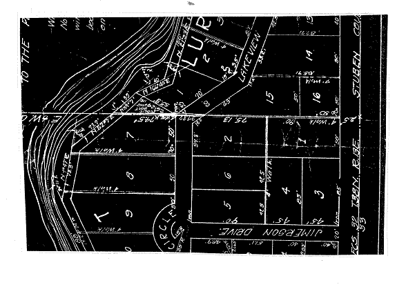
47. Immediately southwest of the McCulloch Lake Lot is a
roughly triangular parcel of real estate which is depicted on the Plat Map as a
“public boat landing” (the “Public Boat Landing”). On the northwest, the Public Boat Landing borders
[VOLUME 12, PAGE 49]
48. The Plat Map indicates the straight-line distance is 40
feet between the two lot lines of the McCulloch Lake Lot at the
49. Schramm’s Lot and Day’s Lots do not convey to Schramm or
Day riparian ownership along
E. Payment of Property Taxes and Adverse Possession
50. In addition to the traditional
elements for establishing adverse possession (now modernized as set forth in Finding
23), the Indiana General Assembly in 1927 adopted a statute making payment of real
estate taxes a condition for acquiring title through adverse possession. Acts 1927, ch. 42, §1, p. 119 (now codified,
with some changes, at IC 32-21-7-1).
This statute today provides:
51. The
52. One problem with IC 32-21-7-1
is that it does not readily apply to a frequent adverse possession situation
where the dispute involves a relatively small difference in the location of a
boundary line between parcels. “Under
[VOLUME 12, PAGE 50]
53. Recognizing the problem, the
54. In 2005, the Indiana Supreme
Court reinstated the requirement of IC 32-21-7-1 in Fraley v. Minger, at 493, but also took into account the logic of Echterling v. Kalvaitis and the legislature’s acquiescence in the
latter case’s interpretation of the statute.
“[W]hen the adverse claimant has a reasonable and good faith belief that
the claimant is paying taxes during the period of adverse possession”, the
requirement of IC 32-21-7-1 may be satisfied even though the belief is
mistaken. If the disputed real estate is
a narrow strip of land along the boundary between two parcels, the imprecision
inherent in ambiguous tax records could easily allow both the claimant and the
respondent to “reasonably believe” they were paying taxes on the disputed real
estate. If the disputed land is a more
substantial parcel, greater evidence that the claimant paid the taxes may be
required. “Dealing with Unwritten Title
Transfers” at p. 75 citing Dewart v. Haab
at 697.
55. Schramm’s
56. Additionally, Donald Day
testified he never paid taxes for the Public Boat Landing. No person testified Gerald Schram ever paid
taxes on the Public Boat Landing.
Although Michael McCulloch disavows ownership of the Public Boat
Landing, he testified he believes he paid property taxes for several years on
the Public Boat Landing based upon an error by the Steuben County Assessor. This belief formed the primary basis upon
which McCulloch sought a reduction from the Steuben County Assessor in the
amount of his taxation. Respondents’
57. The Respondents provide no basis for a determination that they ever paid, or even that they mistakenly believed they ever paid, property taxes for the Public Boating Landing. The only party who may have paid property taxes is the Claimant. The Respondents fail the requirements of IC 32-21-7-1. As a matter of law, without evaluating the elements contained in Finding 23, the Respondents have not sustained their burden of proof for establishing adverse possession of the Public Boat Landing. In the absence of this proof, the Respondents have no riparian rights based upon adverse possession.
F. Riparian Rights
Derived from the Public Boat Landing
58. The Public Boat Landing is real estate that is adjacent to Jimmerson Lake and whose owner has riparian rights. See, also, Finding 47.
[VOLUME 12, PAGE 51]
59. In their draft “Findings of
Fact, Conclusions of Law and Orders”, the Respondents would have the Commission
conclude that the Public Boat Landing “is not public in the sense of being
governmentally owned or operated but rather is an easement which is part of the
plat of Lury’s Cove[2]
which includes the land owned by all parties involved in this action.”
60. The record establishes no
basis for a finding the Respondents are riparian owners. Even so, a determination that persons are not
riparian owners “does not settle the question of whether they are entitled to
install and use” a pier. An easement may
convey this right to the dominant estate.
Klotz v. Horn, 558 N.E.2d
1096, 1097 (
61.
The intentions of a riparian owner who grants an easement are to be implemented
in construing the easement. In a plat or
other recorded conveyance, clear language controls. “Dominant owners of lakeside easements may
gain the rights to erect and maintain piers, moor boats and the like by the
express language of the creating instrument.”
Klotz at 1097 and 1098. The Commission has determined a right-of-way
for lake ingress and egress and “for the maintenance of a boat and swimming
pier” expressed a clear intent and established the right to place a pier, even
though the right-of-way was only three feet wide. Havel
& Stickelmeyer v. Fisher, et al.
at 11 Caddnar 110, 117 (2007).
62. The
current status of the law was summarized in Parkison
v. McCue, 831 N.E.2d 118, 128 (
Easements burdening land with riparian rights attached do not
necessarily provide the easement holder use of these riparian rights. Brown
v. Heidersbach, 172
[VOLUME 12, PAGE 52]
63. In his draft “Findings of Fact
and Conclusions of Law”, McCulloch would have the Commission conclude the
Public Boat Landing is either owned by the State of
64. Implicit to the Commission’s
regulatory structure for the Lakes Preservation Act is that a riparian owner
may acquiesce in the placement of temporary piers and similar structures by
another person. See, for example, 312
IAC 11-3-1(a)(9).
65. Under the draft conclusion
referenced in Finding 59, the Respondents
might secure a right to place a pier or piers based upon an easement for their
benefit which resulted from the grantor’s intent in establishing the Public
Boat Landing. Under the draft conclusion
referenced in Finding 63, the Respondents
might secure a right to place a pier or piers based upon the permission of the
State of
66. The Commission has construed the rights of persons claiming riparian rights based upon a common access in two recent proceedings. Pipp v. Spitler, et al., 11 Caddnar 39 (2007) and Havel & Stickelmeyer v. Fisher. In those proceedings, an effort was made to identify and serve the potential beneficiaries of the easement. Where the county had a colorable claim to the property used for access, the board of county commissioners was served. In addition, service by publication was made upon persons whose identities could not with reasonable effort be ascertained.
67. Although McCulloch and the Respondents all likely have standing to participate in a determination of the proper usage of the Public Boat Landing, they do not individually or collectively have the requisite interests to cause the Commission to make the determination. Other persons needed for just adjudication of the proper usage of the Public Boat Landing are not included in this proceeding.
68. To determine proper usage of the Public Boat Landing, a
diligent effort must be made to identify the owners of each of the parcels in
Leo’s Point Addition and Lury’s Cove Addition and to provide service upon them.[3] The Board of County Commissioners of
[VOLUME 12, PAGE 53]
69. A determination of the proper usage of the Public Boat
Landing is also essential to deciding the Respondents’ claim for a prescriptive
easement. If the Public Boat Landing is
an easement, the intent of which is to allow the placement of piers by lot
owners in Leo’s Point Addition and Lury’s Cove Addition, the placement of piers
by the Respondents may not be hostile to the intent. If the Public Boat Landing is owned by
G. Riparian Zones
70.
71. A “reasonableness” test is applied to how far a pier may
extend into a lake from the shoreline. The
installation of a pier by a riparian owner is unreasonable if the pier
interferes with the use of a public freshwater lake by others. “One point is well settled…the boundaries of
riparian property do not extend to the middle of the lake.” Any extension of a pier or similar structure beyond
the point required for the mooring and launching of boats may be considered
unreasonable. Zapffe v. Srbeny, 587 N.E.2d 177 (
72. The evidence does not support a finding that the length from shore of any of the existing structures at issue violates the reasonableness test.
73. Boundaries between neighboring riparian owners are
delineated according to principles that seek to accommodate the diverse
characteristics of
74. At hearing, McCulloch and the Respondents agreed that
the riparian zones of the Public Boat Landing and the McCulloch Lake Lot should
be delineated by extending their common boundary in a straight line into
75. In part because the site enjoys the geographic benefits
of a peninsula, this delineation is sufficient to provide the Public Boat
Landing and the McCulloch Lake Lot with equitable access to public waters
without apparent disruption to the enjoyment of their neighbors north and
south. The delineation agreed between
McCulloch and the Respondents is appropriate.
Subject to the “reasonableness” test, the riparian zones of the Public
Boat Landing and the McCulloch Lake Lot are properly delineated by extending
their common boundary in a straight line into
[VOLUME 12, PAGE 54]
H. Setback of
Structures from Common Boundary
76. The Commission policy for setbacks between riparian zones is set forth in “Riparian Zones within Public Freshwater Lakes and Navigable Waters”, Information Bulletin #56 (First Amendments) at www.in.gov/legislative/iac/20081210-IR-312080891NRA.xml.html.
To
assist with safe navigation, as well as to preserve the public trust and the
rights of neighboring riparian owners, there ideally should be 10 feet of
clearance on both sides (for a total of 20 feet) of the dividing line between
riparian zones. At a minimum, a total of 10 feet is required that is clear of
piers and moored boats, although the area may be used for loading and unloading
boats and for active recreation.
The policy cites Havel & Stickelmeyer v. Fisher at 119 and Rufenbarger, et al. v. Blue, et al., 11 Caddnar 185, 194 (2007).[4]
77. McCulloch should be ordered to refrain from placing a
pier or mooring a boat within ten feet from the line described in Finding 75. In effect, there should be at least ten feet
of clearance between his pier or piers, and any of his moored boats, southwesterly
to the extended common boundary line with the Public Boat Landing into
[VOLUME 12, PAGE 55]
78. In the absence of persons needed for just adjudication, the ownership of the Public Boat Landing cannot be determined in this proceeding. Until ownership is determined, no person should place a pier or moor a boat within the riparian zone adjacent to the Public Boat Landing. This restriction does not prohibit usage of the riparian zone for loading and unloading boats or for active recreation.
79. The clearance described in Finding 77 is delineated without prejudice to McCulloch, from seeking a modified clearance, through an individual license application to the DNR, made under the Lakes Preservation Act and 312 IAC 3-11-1 through 312 IAC 3-11-5.
80. The restriction described in Finding 78 is made without
prejudice to the owner of the Public Boat Landing from seeking authorization to
place a pier or moor a boat, through an individual license application to the
DNR, made under the Lakes Preservation Act and 312 IAC 3-11-5. In addition, the owner of the Public Boat
Landing is not disqualified by Finding 78 from acting under a general license. If the owner of the Public Boat Landing acts
under a general license, however, it should be ordered to refrain from placing
a pier or mooring a boat within ten feet from the line described in Finding
75. In effect, there should be at least
ten feet of clearance between its pier or piers, and any of its moored boats,
northeasterly to the extended common boundary line with the McColloch Lake Lot
into
I. The Relationship
of the Respondents to the Public Boat Landing
81. The Respondents have not established they are the owners of the Public Boat Landing or that the owner of the Public Boat Landing has conferred upon the Respondents the opportunity to enjoy its riparian rights. The Respondents should be ordered to refrain from placing a pier, boat station, platform or similar structure in the riparian zone of the Public Boat Landing.
82. In an action which includes parties as outlined in
Finding 68, the Respondents may seek to establish ownership of the Public Boat
Landing. As lot owners within Leo’s
Point Addition or Lury’s Cove Addition, they may be determined to enjoy special
rights in the management of the Public Boat Landing. The disposition may provide for a common use
if needed to accommodate the interests of multiple landowners having rights to
access and use the riparian zone adjacent to the Public Boat Landing. IC 14-26-2-23(e)(2)(A) and 312 IAC 11-3-4. The disposition may determine whether the
Respondents have established property rights through a prescriptive easement
against the owner of the Public Boat Landing and an adjacent riparian owner or
owners. The disposition may identify
83. Depending upon the disposition of an action brought as outlined in Finding 68, the Respondents may establish entitlement to place a pier, boat station, platform or similar structure in the riparian zone adjacent to the Public Boat Landing.