[CITE: Havel & Stickelmeyer v. Fisher, et al.,
11 CADDNAR 110 (2007)]
[VOLUME 11, PAGE 110]
Cause #: 05-212W
Caption: Havel &
Stickelmeyer v. Fisher, et al.
Administrative Law Judge:
Lucas
Attorneys: Snyder (Claimants);
Kolbe (Respondents); Eherenman (Malcom Landis Estate); Leininger (Robinson);
Walmer (Werstler); (Other named parties were dismissed or defaulted)
Date: April 13, 2007
Final Order
Paragraph
A. With respect to the disputes as to riparian
rights arising generally west of and along the western side of real estate
owned by Henry A. Havel and Mary P. Stickelmeyer:
(1)
The boundary separating the riparian areas of the Claimants and Robinson is a
straight-line extension into
(2)
The Fishers hold the dominant estate and Robinson the servient estate for an
easement that is three-feet wide, parallel to the riparian boundary described
in part (1) of Paragraph A, and immediately west of the Claimants’ riparian
area. The Fishers are entitled to use
the easement for the maintenance of a boat and swimming pier. The Fishers shall not cause or allow any
portion of the pier to extend outside the easement and shall not cause or allow
any portion of a boat to be docked or moored east of the easement, but they may
dock or moor a single boat parallel to and west of the easement. The boat must be maintained as closely to the
pier as is in keeping with good practices of recreational boating and must be
of a type and size that is common to recreational boating on Winona Lake.
(3)
Robinson shall refrain from placing a pier or mooring a boat that would
constrict open water, to less than a width of 16 feet, for ingress or egress to
the pier described in part (2) of Paragraph A.
Paragraph
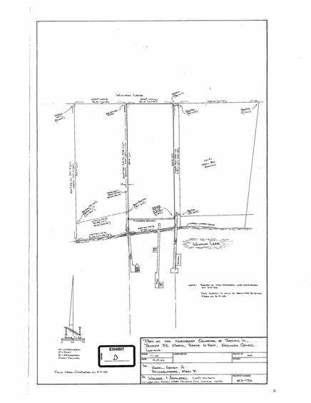
B. With respect to the disputes as to riparian
rights arising generally east of and along the eastern side of real estate
owned by Henry A. Havel and Mary P. Stickelmeyer:
(1)
The boundary separating the riparian areas of the Claimants and the Handels is
a straight-line extension into
[VOL. 11, PAGE 111]
(2)
The Kauffmans, the Calhouns, the Landis Estate and Werstler jointly hold the
dominant estate (exclusive of all other persons) and the Handels the servient
estate for an easement that is ten-feet wide, parallel to the riparian boundary
described in part (1) of Paragraph B, and immediately east of the Claimants’
riparian area. The Kauffmans, the
Calhouns, the Landis Estate and Werstler are entitled to use the easement for a
pier and landing, as well as for bathing beach facilities along the shoreline
of
Findings of Fact and
Conclusions of Law
A. Statement of
the Case, Defaults, Dismissals and Jurisdiction
1. Henry A. Havel
and Mary P. Stickelmeyer (collectively the “Claimants”) filed a “Petition for
Administrative Review” with the Natural Resources Commission (the “Commission”)
on December 15, 2005. The petition
sought the resolution of a dispute as to riparian rights for the placement of
temporary piers and the docking of boats on
2. This proceeding
is governed by IC 4-21.5 (sometimes referred to as the “Administrative Orders
and Procedures Act” or “AOPA”). The
Commission has adopted rules at 312 IAC 3-1 to assist with its implementation
of AOPA.
3.
4. The Commission has
adopted rules at 312 IAC 11-1 through 312 IAC 11-5 to assist with
implementation of its responsibilities under the Lakes Preservation Act.
5. A dispute
concerning the exercise of riparian rights within a public freshwater lake is
subject to administrative review by the Commission under AOPA. IC 14-10-2-3 and IC 14-26-2-23.
[VOL. 11, PAGE 112]
6. For
consideration in this proceeding is the exact location of the Claimants’
riparian boundaries; whether the placement of temporary piers and the docking
of boats on property west and on property east of the Claimants encroaches upon
the Claimants’ riparian areas; and, if so, whether the encroachments are
authorized by a prescriptive easement or easements.
7. The Commission
has jurisdiction over the subject matter of this proceeding.
8. The Claimants
are the owners of real estate located in
Commencing at a point that is 178.75 East of the North Quarter
post of Section 16, Township 32 North, Range 6 East; thence South to a point
that is 200 feet North of the low water mark of Winona Lake for a place of
beginning; running thence West 81 feet tot stake; thence South 200 feet to the
low water mark of Winona Lake; thence Easterly along the low water mark of
Winona Lake 81 feet, more or less, to a point due South of the place of
beginning; thence North 200 feet to the place of beginning.
This real estate is referenced as the “Claimants’ real estate”.
9.
Marcia Robinson (“Robinson”) is the owner of real estate
located in Kosciusko County, which is bound by the waters of Winona Lake, and
which borders and is immediately west of the Claimants’ real estate. The common address of Robinson’s real estate
is
10. Craig S. Fisher and Vicki L. Fisher (the “Fishers”)
own the property commonly known as
11.
The
Fishers are the successors in interest and enjoy the dominant estate for a
three-foot wide easement across the eastern extremity of the Robinson’s real
estate. This easement borders and is
immediately west of the Claimants’ real estate.
The easement was described in a Warranty Deed from Jack E. Essenburg and
M. Irene Essenberg to Larry W. Nellans and Diana K. Nellans, and dated August
14, 1972, as follows:
Subject and reserving to the grantors herein, their heirs,
successors and assigns, a perpetual easement and right-of-way over, along and
upon the [Robinson’s real estate], to-wit: Commencing at the Northeast corner
of the [Robinson’s real estate] and running thence West along the North line
thereof a distance of 3 feet to a point; thence South parallel with the East
line of said tract to the low water line of Winona Lake; thence Northeasterly
along said low water line to the Southeast corner of said tract; and thence
North along the East line said tract to the place of beginning; and which
easement and right-of-way hereby reserved shall run with the land and inure to
the exclusive benefit and use of the grantors herein, their heirs, successors
and assigns, as owners of that part of the [Fishers’ real estate]; and with
said easement and right-of-way to remain open and unobstructed for the use and
benefit of the grantors and their said heirs, successors and assigns, for means
of ingress to and egress from said Winona Lake and, in connection therewith,
for the maintenance of a boat and swimming pier connecting the Southerly end of
said easement and extending into said lake.”
[VOL. 11, PAGE 113]
This easement is referenced as the “Fishers’ easement”.
12. The Fishers’
easement is also subsequently referenced in a Corrected Warranty Deed, dated
August 1, 2003, from Sean M. Rhodes and Deborah Rhodes to the Fishers:
Also conveying a perpetual easement and right-of-way reserved by
the Grantors herein by deed dated August 14, 1972, recorded August 18, 1972, in
deed record 242, page 114, in the Office of the Recorder of Kosciusko County,
Indiana, which easement and right-of-way hereby reserved shall run with the
land and inure to the exclusive benefit and use of the grantees herein, their
heirs, successors and assigns, and with said easement and right-of-way to
remain open and unobstructed for the use and benefit of the grantees and their
said heirs, successors and assigns for means of ingress to and egress from said
Winona Lake and, in connection therewith, for the maintenance of a boat and
swimming pier connecting the Southerly end of said easement and extending into
said lake.
13.
R. John Handel and Susan E. Handel (the “Handels”) are the
owners of
14. Kent D. Kauffman
and Karen Kauffman (the “Kauffmans”) own Lot 9 in the Subdivision of Outlot
Number One in the North Bay Addition to the City of
15. Douglas Calhoun
and Ruby Calhoun (the “Calhouns”) own Lot 10 in the Subdivision of Outlot
Number One in the North Bay Addition to the City of
16. The Estate of
Malcolm H. Landis (the “Landis Estate”) owns Lot 11 in the Subdivision of
Outlot Number One in the North Bay Addition to the City of
17.
Charlotte L.
Werstler (“Werstler”) owns Lot 16 in the Subdivision of Outlot Number One in
the North Bay Addition to the City of
[VOL. 11, PAGE 114]
18.
On
May 3, 1952, W. Robert Hall and Adalene Hall (the “Halls”) platted North Bay
Drive Addition in
19.
In May 1953, the
Halls conveyed the Landis Estate’s real estate to Paul and Mabel Landis (the
“Landises”). As part of this conveyance,
the Halls granted to the Landises the rights to use an easement to
. . .,
together with the right running with said above described tract as the dominant
tenement, to use as a private easement of way, a strip of ground 9 feet in
width East and West and extending from the aforesaid public road at the
Northwest corner of Lot 1 in North Bay Drive Addition aforesaid South to the
low water mark of Winona Lake and lying adjacent to and adjoining the West side
of Lot Number 1 in North Bay Drive Addition aforesaid, with the use of the lake-front area 10 feet in width for pier, landing
and bathing beach facilities at the Southern terminus of said strip on the
shore of Winona Lake, the private easement and right of use hereby
granted not to be exclusive, but to be enjoyed by the grantees, their family
and guests and their heirs, executors, administrators and assigns, in common
with the grantors, and other licensees of the grantors hereafter.
This easement is referenced
as the “
20. The
21. On October 23,
1956, the Halls, the Landises and another property owner signed and recorded
the plat for the Subdivision of Outlot #1 (the “Outlat Plat”).
22. The Outlot Plat
designated the Kauffmans’ real estate as Lot 9, the Calhouns’ real estate as
Lot 10, the Landis Estate’s real estate as Lot 11 and the Werstler’s real
estate as
23. The Kauffmans,
the Calhouns and the Landis Estate were all granted the rights to use the
[VOL. 11, PAGE 115]
24. The
25. The Commission
caused the appointment of an administrative law judge who served a “Notice of
Prehearing Conference” upon the Fishers, the Calhouns and Kent D. Kauffman for
a prehearing conference to be held in this proceeding on January 24, 2006.
26. On January 23,
2006, the Estate of Landis filed its “Petition for Intervention”.
27. During a January
23, 2006 prehearing, the “Petition for Intervention” by the Landis Estate was
granted without objection. The parties agreed
there likely were other persons who could be affected by a disposition and who should
be notified of this proceeding. The participating
parties agreed upon a process for identifying potentially affected persons and
for establishing a notice by publication to persons whose names or addressed
could not reasonably be identified.
28. On January 30, a
draft notice for publication was forwarded by the administrative law judge to
the parties. The parties were provided
until February 13, 2006 to suggest any additions or corrections to the
notice. All of the participating parties
responded by email that the form and content of the notice were acceptable to
them.
29. The notice by
publication was published on February 20, 2006 in the
30. The parties
timely provided a listing of additional persons who they believed might be
interested in the outcome of this proceeding.
Based upon the listing, the administrative law judge entered a “Notice
to Third Party Respondents” on February 27, 2006. A copy of the “Notice to Third Party
Respondents”, together with a copy of pleadings, documents, and entries
previously made in the proceeding, were sent to the following persons: R. John Handel and Susan E. Handel; James A.
Rhodes and Bonnie J. Rhodes; Kent D. Kauffman and Karen L. Kauffman, Joseph M.
Thallemer and Jill E. Thallemer, Jacqueline J. Hollar, Timothy A. and Lili
Polk, Sterling L. Watkins and Sarah Watkins, Danny M. French, George A. Seymour
and Leatrice J. Seymour, Douglas Calhoun and Ruby Calhoun, Malcolm Landis,
Wayne L. Welty and Naomi R. Welty, the Cardinal Center, Inc., Russell L. Heyde,
Particia Hede, Eldon L. Werstler and Charlotte L. Werstler, Edith A. Neer
Revised Living Trust, Frauhiger Realty Co., LLC, Linda Lou Jones, the Board of
Commissioners of Kosciusko County and Marsha Robinson. The Third Party Respondents were directed to
file responses under AOPA and 312 IAC 3-1 by March 24, and they were notified
of a prehearing conference scheduled for
[VOL. 11, PAGE 116]
31. Linda Lou Jones
disclaimed any interest in the proceeding, and a final order of dismissal was
entered as to her. With the exception of
the Kauffmans, the Calhouns and the Landis Estate, a final order of default was
entered on April 21, 2006 with respect to all other persons described in
Finding 30. This final order of default
was subsequently set aside, however, as to “Marsha Robinson”, whose real name
is “Marcia Robinson”, and as to Charlotte L. Werstler. These are “Robinson” and “Werstler” as
defined previously in these Findings.
None of the persons against whom final orders of default were issued
have sought judicial review of the defaults.
Except for the Claimants, Robinson, the Fishers, the Kaffmans, the
Calhouns, the Landis Estate and Werstler, any claim to riparian rights
(including those arising under a recorded easement or a prescriptive easement),
which a person could assert in this proceeding, have previously been foreclosed
and terminated.
32. The Commission
has jurisdiction over all persons needed for just adjudication.
33. A full and fair
opportunity was provided to interested persons to participate in the
proceeding, and a hearing was conducted as scheduled at
B.
Determinations of Riparian Boundaries
34.
The
35.
The delineation
of riparian boundaries within a lake may require a professional survey and the
application of legal principles. M. Anne French v. Abad, et al., and DNR,
9 Caddnar 176 (2004) citing Bath v.
Courts and Nosek v. Stryker.
36.
The
most persuasive document to make this delineation, for both the western
riparian boundary and the eastern riparian boundary of the Claimants’ real
estate, is the survey of Walker and Associates (certified September 19, 2005)
and admitted into evidence as Exhibit D.
The survey demonstrates that the property lines of the Claimants’ real
estate intersect the shoreline of
37.
In
addition, during the hearing, the administrative law judge inquired if the
“parties agree that the appropriate delineation is a straight line extension of
the property lines into the lake.” The
parties agreed that it was.
[VOL. 11, PAGE 117]
38.
The
riparian boundary on the western side of the Claimants’ real estate, and the
riparian boundary on the eastern side of the Claimants’ real estate, are both
properly determined by extending the onshore boundaries as straight lines into
C. Application of the Fishers’ Easement
39.
The
Fishers are the successors in interest and enjoy the dominant estate for a
three-foot wide easement across the eastern extremity of the Robinson’s real
estate. Robinson is the servient
tenant. The Fishers’ easement borders
and is immediately west of the Claimants’ real estate.
40.
Robinson is a
riparian owner, but the Fishers are not riparian owners. Yet a determination
that persons are not “riparian owners does not settle the question of whether
they are entitled to install and use a dock in the property enjoyment of their
easement for right-of-way purposes.” An
easement holder does not have riparian ownership status but may use the
riparian rights of the servient tenant who has given access to the lake. Klotz v. Horn, 558 N.E.2d 1096, 1097 (
41.
Fishers’ easement
provides them with a three-foot wide “right-of-way to
remain open and unobstructed” for their use for a means of ingress to and
egress from Winona Lake “and, in connection therewith, for the maintenance of a
boat and swimming pier connecting the Southerly end of said easement and
extending into said lake.”
42.
In
her post-hearing brief, Robinson cites Gunderson
v. Rondinelli, 677 N.E.2d 601 (Ind. App. 1997) as standing for the
propositions that (1) an easement should be construed to limit its uses to
those which are reasonably necessary to carry out the original intent while
putting the least burden on the servient estate; and, (2) that the width of an
easement is indicative of the grantor’s intent.
43.
These
propositions are applicable to this proceeding, but there are critical factual
distinctions. In Gunderson, the easement was merely for ingress and egress to lake
access.
44.
Robinson
also cites the dissenting opinion in Klotz
v. Horn. There Justice DeBruler
would have found a six-foot wide easement was “a sylvan foot path, intended for
the transportation of no more than what a person or two might carry and to
facilitate the simplest of lakeside pleasures.”
The DeBruler dissent, in addition to being legally unpersuasive as in Klotz, is at odds with the facts here.
[VOL. 11, PAGE 118]
45.
The
clear language of the Fishers’ easement is that it entitles them to a pier for
the maintenance of a boat and for ingress and egress to
46.
Even
so, the Fishers’ easement must properly be construed within the factual context
that it borders the riparian area of another riparian owner, the Claimants, and
that it is only three feet wide.
47.
In
their post-hearing brief, the Fishers cite Barbee Villa Condominium Owners Assoc.
v. Shrock, 10 Caddnar 23 (2005) as
standing for the proposition that they are entitled to moor their boats on both
sides of their pier. Barbee Villa was an application of
common law, most notably Bath v. Courts,
cited previously, and of Zapfee v. Srbeny, 587 N.E.2d 177
(Ind. Ct. App. 1992). Enjoyment of
riparian rights by one person cannot encroach on the riparian rights of
another. A “reasonableness” test should
be applied. “Mooring a boat is an
exercise of proprietary rights and would typically be unreasonable in the same
locations where a pier would be unreasonable. If the location of a pier were to
violate the ‘reasonableness’ test, typically a boat moored in that same location
would also violate the ‘reasonableness’ test.” Barbee Villa at p. 26. The holding in Barbee Villa was that a pier and a boat moored to the pier must be
placed so as not to enter and encroach upon the riparian area of a
neighbor. If a boat were to be moored on
a neighbor’s riparian area, it would violate the spirit of both
48.
Consistently with Barbee
Villa, Robinson could not place a pier or moor a boat within the riparian
area of the Claimants. The Fishers’
easement is derived from Robinson’s real estate, and the interest transferred
in the easement can be no more than that of the Robinson’s real estate. Consistently with Barbee Villa, the Fishers cannot place a pier or moor a boat within
the riparian area of the Claimants.
49.
The narrow three-foot width of the Fishers’ easement indicates
an intention by the original parties in 1972 that its usage be modest. Because the intention could not lawfully or
reasonably have been to provide an opportunity to moor a boat on the east side
of a pier, the intention must either have been to provide an opportunity to
moor a boat at the lakeward end of the pier or on the west side of the
pier. The more likely intention would
have been to authorize the mooring of a boat on the west side of the pier. This conclusion is reached for two reasons. First, the easement is so narrow that it would
not have fully accommodated the beams of ordinary recreational boats even in
1972. Second, the more common and
ordinary practice is to moor a boat along the side of a pier than at the end of
a pier. At the same time, the narrow
width of the easement clearly evidences that its purpose was to authorize the
mooring of a single boat, enough to provide ingress and egress to the open
waters of
[VOL. 11, PAGE 119]
50.
The Fishers’ easement is found to authorize their placement of a
single boat on the west side and parallel to a pier, placed as closely to the
pier as is in keeping with good practices of recreational boating. The boat is to be of a type and size that is
common to recreational boating on
51.
Based upon expert testimony, the Commission has previously found
that a minimum of from 10 to 16 feet should be maintained to provide for safe
navigation between piers, but 20 feet is preferred. Sims, et al. v. Outlook Cove, LLC and Outlook Cove
Homeowners Ass’n, 10 Caddnar 258, 279
(2006) and Roberts v. Beachview Properties,
LLC, et al.,
9 Caddnar 163, 166 (2004).
52.
In
order to provide the opportunity for safe navigation, Robinson shall refrain
from placing a pier or mooring a boat that would constrict open water, to less
than a width of 16 feet, for ingress or egress to the pier on the Fishers’
easement.
D. Application of the
53.
The
Kauffmans, the Calhouns, the Landis Estate and Werstler are the successors in
interest and together enjoy the dominant estate for the
54.
All
property owners in the North Bay Plat and the Outlot Plat were made a party to
this proceeding, either with personal service or by publication, and were
notified to appear and to assert any riparian rights they might have arising
from the North Bay easement. With the
exception of the Kauffmans, the Calhouns, the Landis Estate and Werstler, all
of the property owners in the North Bay Plat and the Outlook Plot were
defaulted. As a consequence, the only
property owners in the North Bay Plat or the Outlot Plat that have any riparian
rights arising from the North Bay easement are the Kauffmans, the Calhouns, the
Landis Estate and Werstler.
55.
The
56.
The
[VOL. 11, PAGE 120]
57.
To
the extent the North Bay easement may not have expressly authorized the
installation of a pier, the Kauffmans, the Calhouns, the Landis Estate and
Werstler are individually and jointly entitled to a default judgment of quiet
title, adverse possession and prescriptive easement, authorizing them to
install a pier extending from the shoreline into Winona Lake and within the
North Bay easement, against the Handels and the other property owners in the
North Bay Plat and the Outlot Plat.
Additionally, the default judgment entitles the Kauffmans, the Calhouns,
the Landis Estate and Werstler to cause boats to be moored so that not more
than two-thirds of a boat extends east of the eastern boundary of the
58.
Consistently with Barbee
Villa, Handels could not place a pier or moor a boat within the riparian
area of the Claimants. The
59.
No
disposition is made in these Findings regarding the configuration of moorings
or docks within the
E. Prescriptive Easements to Extend the
Fishers’ Easement or the
60.
Over
the years, the reported
[VOL. 11, PAGE 121]
61.
In Fraley v. Minger, 829 N.E.2d 476, 483 (
Deferring to the majority of cases that have actually discussed
the quantum of proof issue, we find that the heightened standard is
appropriate. Employing current
terminology, however, we believe that ‘clear and convincing’ is a preferable
way to describe the heightened standard needed to establish possession, thus
embracing and superseding the variety of terms previously used.
62.
As a
consequence of Fraley, in order to
sustain a claim of adverse possession, the party asserting the claim must prove
by clear and convincing evidence each of the following four elements:
1. Control: The person asserting adverse possession must exercise
a degree of use and control over the parcel that is normal and customary
considering the characteristics of the land (reflecting the former elements of
“actual”, and, in some ways, of “exclusive” possession).
2. Intent: The person asserting adverse possession must
demonstrate intent to claim full ownership of the tract superior to the rights
of all others, particularly the legal owner (reflecting the former elements of
“claim of right”, “exclusive”, “hostile” and “adverse”).
3. Notice: The person asserting adverse possession must
demonstrate its actions with respect to the land were sufficient to give actual
and constructive notice to the legal owner of the control and the intent
elements (reflecting the former “visible”, “open”, “notorious”, and in some
ways “hostile” elements).
4. Duration: The person asserting adverse possession must
demonstrate control, intent and notice existing continuously for the required
period of time (reflecting the former “continuous” element).
63.
IC
32-23-1-1 requiring 20 years of use was not modified by the Indiana Supreme
Court in Fraley.
64.
In
the first decision following Fraley,
the Indiana Supreme Court applied the same elements to a claim of prescriptive
easement in Wilfong v. Cessna Corp.,
838 N.E.2d 403 (Ind. 2005). The Court
stated: “This reformulation applies as well for establishing prescriptive
easements, save for those differences required by the differences between fee
interests and easements.” Wilfong at 406. Fraley
and Wilfong were recently applied
favorably by the Commission in Belcher
& Belcher v. Yager-Rosales, 11 Caddnar 79, 86 (2007).
[VOL. 11, PAGE 122]
65.
“Prescriptive
easements are not favored by the law.”
On land, physical evidence can help establish adverse use, and an
unexplained use of a path or road for over 20 years offers a presumption of
adverse use. There is not a similar
presumption “in favor of a party trying to establish a prescriptive easement
for the recreational use of a body of water.... Recreational use (especially of
water which leaves no telltale path or road)...seems...likely to be permissive”
rather than an intent that is adverse. Carnahan
v. Moriah Property Owners Ass’n, 716 N.E.2d 487 (
66.
In
order to establish a prescriptive easement to expand the Fishers’ easement over
the riparian area of the Claimants’ real estate, the Fishers would be required
to show by clear and convincing evidence that it had established each of the
four elements described in Finding 62. This
burden of proof must properly be viewed in the context of recreational waters,
such as those of
67.
In
order to establish a prescriptive easement to expand the
68.
None
of the witnesses testified that a pier was placed at the end of the Fishers’
easement until 1997, and no boat was moored at the pier until 2004. Expansion of the Fishers’ easement does not
meet the duration element that is required for a prescriptive easement.
69.
The
Kauffmans, the Calhouns and the Landis Estate claim a prescriptive easement to
a portion of the riparian area of the Claimants’ real estate that is very
small. “Where the quantity of land
involved is small, the rule as to the location of the line is exacting. Possession to the line during all of the
statutory period must be definitely shown.”
Baxter v. Gerard Trust, 135 A.
620, 621 (1927); McCarty v. Sheets,
423 N.E.2d 297, 300 (1981). Werstler did
not make a specific claim for a prescriptive easement, and the record does not
support the issuance of one in her favor.
70.
None
of the witnesses testified as to the exact location of the pier other than
being located at the end of the
[VOL. 11, PAGE 123]
71.
The
evidence is not clear and convincing that the Kauffmans, the Calhouns, the Landis
Estate or Werstler controlled a particular geographic portion of the riparian
area of the Claimants’ real estate.
Additionally, the testimony is as supportive of the proposition that any
historical encroachment in the pier or boats into the riparian area of the
Claimants’ real estate was permissive.
The encroachment of the pier and boats from the