

The Tippecanoe County Soil and Water Conservation District (SWCD) is very excited about two of our ongoing projects: Agriculture Awareness for Youth and Conservation Mapping.
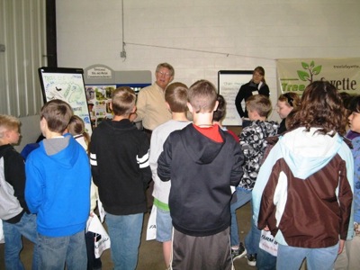
Agriculture Awareness: Each year, local fourth graders come to the Tippecanoe County Fairgrounds to learn about the importance of agriculture in their lives. This year 1,337 students from 20 different schools participated. Displays included farm machinery, livestock and farm animals, corn and soybean products, groundwater protection, and more.
The SWCD's theme for the event was "Forests for People - More than You Can Imagine!" and focused on the importance of trees to Indiana agriculture and all communities. As part of the presentation, students were asked to identify several benefits trees provide to the environment. Their answers included oxygen, shade, soil erosion protection, food, water and beauty. They were also asked to identify byproducts of trees. They easily identified the most common ones, but were surprised to learn that other items like gum, toothpaste, crayons, medicines, glues, and vitamins also come from trees.
Each classroom received a poster about the benefits of trees, and students were given a free dogwood seedling to plant at home or give as a gift. Students also were provided with planting instructions and a brochure on the importance of trees. Partners in this event included the Lafayette Tree Committee, West Lafayette Tree Fund Committee, and the Tippecanoe County Partnership for Water Quality.
Conservation Mapping: Last fall, the SWCD was approached by Purdue University professor in the Earth and Atmospheric Sciences Department. The inquiry centered on an internship for college students to gain practical experience in conservation. Many projects were proposed, however, it was determined that mapping existing and future conservation practices in the county would provide valuable information to the SWCD. The exercise also would be beneficial to the student.
The project goal is the creation of comprehensive maps detailing where conservation exists, who is applying it, and how we can best connect the dots to create a more integrated, productive landscape with a variety of land uses. These maps will include conservation activities completed by the landowner in partnership with local, state and federal conservation organizations. They also will include practices such as grassed waterways, upland game buffers, filterstrips, field borders, wetland restoration, restoration of rare and declining habitats, cover crops, and practices that have a direct effect on water quality and habitat.
At the conclusion of the current semester, the intern will have actually created four maps. One map will identify all conservation practices installed from 1995 forward and include personally identifiable information such as tract number, owner, producer, land use, program, conservation practice and acres. Keeping in mind the importance of USDA�s "Right to Privacy" Act, this map will only be available to NRCS/SWCD personnel. The second map is identical, however; it will contain no personally identifiable information. The remaining two maps will include the same information as above, but will only display practices enrolled into USDA's Wildcat Creek Mississippi River Basin Initiative.