The National Wetland Inventory Mapping Application was created to provide property owners a way to volunteer their land to be used for Wetland and Stream Mitigation and for the public to view potential wetland areas and areas of high priority for wetland restoration. These instructions provide an overview on how to use this online tool to find pertinent information in your area.
Upon opening the application, you will first need to agree to the Terms and Conditions for use with the public portal. Once you have agreed, you will see the statewide view, zoom in and out buttons with a full extent button, a location button for navigating to your current location, and a search box for querying.
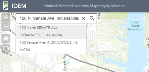
When entering an address into the Search box, the search requires street address, city, and state. You may also search using an intersection when including the nearest town. Once you enter your search criteria, the map will automatically zoom to the selection and highlight your selection. If there are multiple options, they will appear below the search window to allow you to select which is most appropriate.
Another tool provided is a spatial reference bar at the bottom left of the map screen that shows the location of the pointer in latitude/longitude decimal degrees. This can be helpful in locating a specific point anywhere on the map. The default coordinate system for this tool is latitude/longitude in GSC_WGS_1984 (4326).
At the bottom center of the map is an arrow button that will provide a popup of the data for the selected features in each active data layer.
Click on each tab to see what data is available from each layer. Click on a record or group of selected records or set a Filter then click on “Zoom to” to take the map to the selection’s extent. Lastly, there is an Overview reference map window that can be activated using the bottom right corner arrow to toggle it off and on. The left bar list of layers can be toggled to slide left out of view to expand the map area by clicking on the left side arrow button. As always, pan and zoom can also be done using a mouse scroll button.
To volunteer your property for Wetland or Stream Mitigation, search/zoom to the area you wish to volunteer on the map. Select the Report Wetlands edit tool in the upper right portion of the application.
Select Potential Site point and add the point on the map at your location. A box will open for you to add contact and project description information. Please fill this out as complete as possible; when you have completed this, press the Close button.

If you wish to show the specific area you are volunteering for Wetland Mitigation, follow the same steps as above, but select Potential Areas and draw the area on the map. You will be contacted by someone from IDEM regarding your submittal and to confirm all of the relevant information. E-mail contact will come from IDEM.
Verification of new information will take place approximately every two weeks. If you have not heard from someone within two weeks of posting your site, check your spam folder and then follow up with the IDEM Wetlands e-mail address.