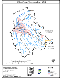
The Walnut Creek – Tippecanoe River Watershed, Hydrologic Unit Code (HUC) 051201060203, is located predominately in Kosciusko County with 2% located in Whitley County to the east. The watershed is an area of land (78,406) that drains to the Tippecanoe River.
The Watershed Management Plan (WMP) for the Walnut Creek – Tippecanoe River Watershed was prepared by The Watershed Foundation, formerly known as the Tippecanoe Watershed Foundation, and the Clean Waters Partnership to enlist community support and commonality of purpose to lead in enhancing public educational work and harness project funding. The WMP describes the issues present in the watershed and the management actions necessary to remediate them. The Indiana Department of Environmental Management (IDEM) currently lists multiple lakes and waterways in the 2016 303(d) list of impaired waters. This document builds on that information adding two years of additional water sampling, a desk-top survey, a partial field survey, and input from local stakeholders. This document represents only the first step of an on-going effort to evaluate & improve the watershed using a cyclical process of planning, implementation, evaluation, modification, and then repeating the process, ad infinitum, to achieve and maintain acceptable water quality within the watershed.