Summary
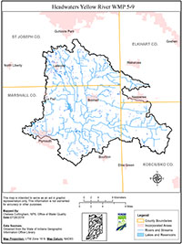
The Headwaters Yellow River Watershed is located within the larger Kankakee Watershed and covers portions of Marshall, St. Joseph, Elkhart, and Kosciusko Counties, Indiana. The watershed is approximately 187,300 acres. The land use of the watershed is predominately agricultural.
Concerns such as: sedimentation from erosion, excessive levels of nutrients, and bacteria brought partners together. The first steering committee meeting took place in March of 2015. There are 17 stream segments, equaling approximately 73 miles of waterways, in the watershed that are listed as impaired on the 303d list for E. coli and Impaired Biotic Communities. In addition, Pleasant Lake, Riddles Lake, and Lake of the Woods are listed for high phosphorus concentrations and Lake of the Woods is also listed for polychlorinated biphenyls (PCBs).
The Marshall County Soil and Water Conservation District applied for and was awarded a 319 grant to develop a watershed management plan (WMP) and an education/outreach program. In 2014, the Marshall County SWCD, through a subcontractor through Cardno, began writing a comprehensive watershed management plan to address nonpoint source water pollution in the watershed.
The WMP is a strategy for achieving water quality goals by characterizing the watershed, setting goals and actions steps, and developing an implementation plan to address documented problems. The Headwaters Yellow River WMP meets the requirements of IDEM’s 2009 Watershed Management Plan Checklist and was approved by IDEM and EPA in May 2018.