Summary
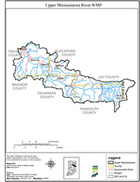
The Upper Mississinewa River Watershed (UMRW) is approximately 415,000 acres and is located in portions of six Indiana counties (Grant, Blackford, Madison, Delaware, Jay and Randolph) as well as a portion of Darke County, Ohio. The UMRW is comprised of five (5) HUC 10 watersheds: Headwaters Mississinewa River (0512010301), Halfway Creek (0512010302), Big Lick Creek (0512010303), Pike Creek (0512010304), and Massey Creek (0512010305).
Fifty-five miles of the Mississinewa River flow through the UMRW. There are approximately 924 miles of streams and ditches flowing into the Upper Mississinewa River, and 300 miles of those streams were listed on the 2014 303(d) list of impaired waterbodies. After water quality issues were recognized, the Delaware County SWCD initiated the development of the Upper Mississinewa River Watershed Management Plan (WMP) and in 2013, the Upper Mississinewa River Watershed Partnership was established.
The Upper Mississinewa River WMP is intended to provide guidance for the improvement of water quality within the UMRW. Critical subwatersheds were identified using a combination of water quality data, watershed inventory and analysis results, and stakeholder concerns. The Upper Mississinewa River WMP also defines implementation strategies to address and reduce identified nonpoint source pollutant loadings in each subwatershed.
The Upper Mississinewa River WMP was completed in January 2018 by Flatland Resources, LLC, on behalf of the Delaware County SWCD. The project was funded by a 205(j) grant awarded by IDEM.