Summary
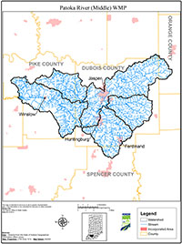
The Middle Patoka River Watershed (MPRW) covers 236,706 acres in Dubois, Gibson, Pike, and Spencer Counties in southwest Indiana. The MPRW is made up of five watersheds that each has a 10-digit Hydrologic Unit Code (HUC) area. Within the 10-digit HUCs are even smaller subwatersheds and each of these has a 12-digit HUC.
The main purpose of this plan is to outline goals and objectives designed to reduce runoff pollution from reaching the Patoka River and its tributaries. Runoff is generated when storm water flows off farm fields, feedlots, parking lots, roofs, and roads. Oils, bacteria, fertilizers, sediment, and other pollutants sitting on these surfaces get washed off by storm water and enter the streams. These pollutants are deposited by normal everyday activities like lawn and garden maintenance, livestock production, agricultural practices, and construction. The storm water carrying these pollutants can alter the temperature of the stream, damage aquatic habitat, and add sediment to the stream flow by scouring the channel and banks. Sometimes storm water is even considered a pollutant that harms a watershed’s health.
This Source Water Protection Plan (SWPP) was written to meet the requirements of a watershed management plan (WMP) as defined by the Indiana Department of Environmental Management’s (IDEM) Section 319 Grant Program. Meeting IDEM standards allows stakeholders to apply for State grant money to improve the watershed. The differences between a source water plan and a watershed plan are minimal; the former includes information about drinking water sources while the latter may not. The creation of this plan is not government mandated and participation is voluntary. The Alliance of Indiana Rural Water wrote this plan anticipating the community will embrace it and choose to implement its goals.