Summary
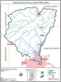
The Morse Reservoir and Cicero Creek watershed (10-digit HUC 0512020106) is located in Hamilton, Boone, Tipton and Clinton Counties, Indiana. Originating in Clinton County, Cicero Creek flows northeast through Tipton County before turning south and flowing through central Hamilton County. The Morse Reservoir/Cicero Creek Watershed consists of approximately 144,343 acres of mixed land use; Morse Reservoir occupies 1,500 acres itself.
Morse Waterways Association (MWA) serves the Morse Reservoir community by promoting safety and the environment. To further achieve this goal, MWA partnered with the Upper White River Watershed Alliance (UWRWA) to develop this Watershed Management Plan, funded using the Indiana Department of Natural Resources’ Lake and River Enhancement Program (IDNR LARE).
The Morse Reservoir/Cicero Creek Watershed Management Plan (WMP) is intended as a guide for the protection and enhancement of the environment and quality of the watershed while balancing the different uses and demands of the community on the this natural resource. This plan will address items such as:
- Education and outreach;
- Increasing preservation, restoration and protection of this vital system;
- Increasing cooperation, coordination and collaboration among all stakeholders in the watershed; and
- Maintaining a solid organization to look to the welfare of this important natural resource. Introduction of project, background of watershed resources, group dynamics, and ground-rules for participation.