The Federal Grants Reporting and Tracking System (GRTS)
You can now find information and details about Section 319-funded projects through the Guest Login to the U.S. EPA’s Nonpoint Source Grants Reporting and Tracking System (GRTS). GRTS is the primary tool for management and oversight of state nonpoint source management programs under Section 319 of the Clean Water Act. The U.S. EPA recently added new tools to the GRTS database to enable the public to search for information about nonpoint source pollution control projects.
GRTS: Overview/Tutorial
Table Querying Tools
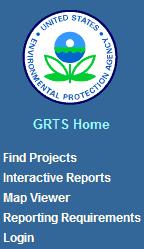
To search for projects, click on the Find Projects link under the GRTS Home navigation bar (depicted to the left). This page provides you with a list of projects and criteria where you can perform a query to search though all projects. This method is best for finding 319 projects that meet certain conditions; for example, nonpoint source projects that implement a Total Maximum Daily Load (TMDL) to control erosion (Type of Project), or projects implementing best management practices for waters polluted by urban run-off (Category of Pollution). Other criteria options include Federal fiscal year (FFY) the project was funded, U.S. EPA Region (05, in which Indiana is a part), State, Project Status, or Has Pollutant Data from monitoring activities. Several criterions can be selected to narrow the search. Of course, if the Project Title is known, there is a query textbox where all or partial names are useful. No wildcard (such as an asterisk) is needed. Also, by clicking on the [View] link at the right of each project, a printable details sheet will pop up in a new window.
Another new search tool is the Interactive Reports link, which enables browsing for project information by watershed and other reporting criteria. To find reports based upon such criteria as Pollutant, HUC12, or Project Budget, use the Interactive Reports link on the navigation bar and the dropdown menu called Select Report on the new page. Overall Project Summary Reports are also provided as the default choice. Another search function includes a query textbox as found on the previous Find Projects page but with an added feature to select the column on which to perform the word search – the dropdown magnifying glass icon to the left of the textbox. However, this page also offers an Actions button for downloading the data and performing additional operations to further fine tune the format and results for a customize report.
Projects by Location using Map Viewer
This viewer enables visualization of nonpoint source projects by watershed boundaries. It utilizes Microsoft Bing Maps for map display and navigation, and connects directly to the GRTS database for access to the most current GRTS project information. The Map Viewer link takes you to a page that has instructions on how to use the application and mapping functions. There are basic functions for pan and zoom buttons to navigate to the location of interest, and the 319 projects will appear, summarized by watershed as pop-ups as you move the cursor around the map and over the tags. This viewer is scale-dependent, so you’ll need to zoom in different levels for more detail. At a regional scale, projects are displayed by subbasins (8-digit hydrologic units), and at a local scale by subwatersheds (12-digit hydrologic units). Also, there are map filter options below the map window that provides the same querying functionality as the Find Projects tool, but within the map viewer interface. These are scale dependent as well, so continue to zoom in to find your area of interest. Note: There may be a message stating that no nonpoint source projects are within the area; zooming in further should change the view, now showing tags in the watersheds within the area that contain project information.
Questions?
If you have any questions regarding Indiana projects listed in GRTS, please contact the IDEM Nonpoint Source Program staff.