Summary
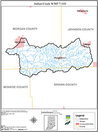
The Indian Creek Watershed is located in the central Indiana counties of Johnson, Morgan, Monroe and Brown. The watershed is included in the larger watershed basin of the Upper White River Basin. The Indian Creek Watershed is an 11-digit watershed that contains seven 14-digit subwatersheds, and encompasses approximately 60,049 acres (93.8 square miles), primarily in Johnson and Morgan Counties. Indian Creek and several of its tributaries, including Bear Creek, Camp Creek, Robertson Creek and Sand Creek were listed on the 2004 Section 303(d) list of impaired waters for Escherichia coli (E. coli), however, the citizens of the Watershed also voiced a number of other concerns regarding water quality. This Plan intends to address the impairment for E. coli and those other concerns.
In a word, diversity best characterizes the Indian Creek Watershed. From the urbanized areas of the City of Martinsville to the rolling hills of the Morgan-Monroe State Forest and the vast acres of Johnson County farmland, the Watershed represents a diversity of land uses, geology, soils and water resources. The Watershed encompasses land from Trafalgar south and west in Johnson County to the eastern half of Martinsville and south in Morgan County and includes areas of the Morgan-Monroe State Forest in Monroe County and the Yellowwood State Forest in Brown County. It includes the two lake communities of Lamb Lakes and Lakes of the Painted Hills.