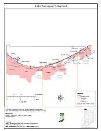
Location
The Lake Michigan shoreline is located in northwestern Indiana, with approximately 45 miles of shoreline in Lake, LaPorte and Porter Counties.
History
A comprehensive survey of the Lake Michigan shoreline was conducted by Indiana Department of Environmental Management (IDEM) between May 1984 and July 2002. The primary cause of impairment is Escherichia coli bacteria (E. coli). Pollution sources in the watershed include nonpoint sources from agriculture and pastures, land application of manure and urban and rural run-off, as well as point sources from straight pipe discharges, home sewage treatment system disposal and combined sewer overflow outlets.
Pollutants Addressed
Total Maximum Daily Loads (TMDLs) for the Lake Michigan shoreline are established for E. coli and will address four impairments. Some of the recommended solutions to address the impairments include storm water controls, point source controls, manure management and habitat improvements.
Timeline
A kickoff TMDL meeting was held on July 25, 2002 at the Northwest Regional Planning Commission, 6100 Southport Rd., Portage, Indiana, starting at 9:00 a.m.
A draft TMDL meeting was held on June 23, 2004 at the Northwest Indiana Regional Planning Commission, 6100 Southport Rd., Portage, Indiana starting at 6:00 p.m.
The 30-day public comment period for the draft Lake Michigan Shoreline TMDL began on June 14, 2004 and ended on July 14, 2004.
U.S. EPA under Section 303(d) of the Clean Water Act approved the Lake Michigan Shoreline TMDL report on September 1, 2004 for four impairments. TMDL reports identify and evaluate water quality problems in impaired water bodies and propose solutions to bring those waters into attainment with water quality standards.